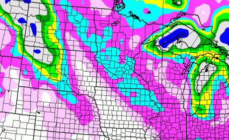
* Alberta Clipper arrives today with light snow, potential for a coating to 1" of accumulation.
* Second clipper arrives Thursday, another stripe of 1-2" possible across central and southern Minnesota. Once again roads may be icy, but we expect under 1" here in the metro Thursday.
* Relatively dry and quiet Friday and Saturday.
* Storm early next week passes well south of Minnesota -
potential for significant snow has lessened somewhat for the metro area, but a few inches can't be ruled out over far southern MN, even the MSP metro area from Sunday night into early Tuesday. Still too early to tell if this will be a weather-maker for the MSP metro area.
* Potentially much colder by the end of next week, highs in single digits across much of Minnesota the latter half of next week?
* Long-range models hinting at a few subzero daytime highs (even for the metro area) between January 16-20,
possibly the coldest stretch of the entire winter.
* The world's largest reinsurance company, Munich Re, said that
950 natural disasters were recorded last year, nine tenths of which were weather-related events such as storms, floods or heat waves.
The total represents the second highest number of natural disasters recorded since 1980 and is 21 per cent higher than the average number of annual incidents recorded over the past decade. More details in a series of stories below the forecast.
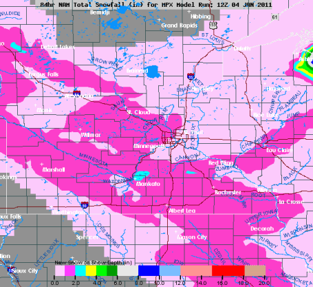
Couple of Clippers. Wednesday and Thurday's snowfall will be concentrated on west central, central and southwestern Minnesota, where some 2-3" amounts are possible. I'm expecting a "nuisance" snowfall in the Twin Cities and St. Cloud, probably 1-2" by Thursday of additional snow by Thursday afternoon.
Candy-Coating of Snow. This close-up of central and southern Minnesota shows the fickle nature of Alberta Clippers, a 75-100 mile wide band of accumulating snow - most towns and suburbs picking up 1/2 to (at most) 2" by Thursday.
Potentially "Plowable". Getting sick of plowable. How 'bout "shovelable?" You get the idea - enough to shovel and plow and generally gum up rush hour. It doesn't take much snow - especially when temperatures are in the teens or colder, for roads (even freeways/interstates) to get VERY icy. A quick 1/2 to 1 inch is possible today, maybe 1 or 2" Thursday. The GFS model(s) are suggesting a couple of inches early next week - with the brunt of the snow/ice passing off a few hundred miles south of Minnesota. Not the end of the world, but just enough powder to add a few minutes to your commute.
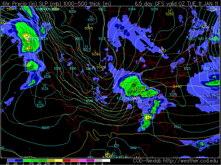
Close Call? The GFS solution valid 7 pm Tuesday evening (displaying pressure for that time and accumulated precipitation for the previous 12 hours) shows a big snowy/icy bullseye to our south across Iowa and Missouri. Previous runs had a more pronounced "inverted trough" lifting north of the main storm center, sparking light snow over much of Minnesota. This model run is a little suspect - not buying it (yet). Although the brunt of the storm will almost certainly pass well south of Minnesota I suspect light snow will extend into at least southern, possibly central Minnesota Sunday night into Tuesday morning. If you're doing any cross-country traveling early next week you'll want to stay up on the latest forecast.
Coldest Of The Winter? I'm going on on another shaky limb here, but if the GFS model verifies, and temperatures at 850 mb (about 3,500 feet above the ground) really do dip down to -26 C on Tuesday, January 18, we could be looking at 2-3 days in a row of subzero highs, even in the immediate Twin Cities metro, with nighttime lows dipping into the -10 to -20 F. range. Not wind chill, but actual air temperature. Something to look forward to.
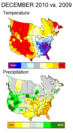
December 2010 Recap. From the meteorologists at
Planalytics in the suburbs of Philadelphia: "
In North America, December was the driest since 2001 and warmest since 2007. In terms of precipitation, this was a drastic change from December 2009, which was the 3rd wettest in 50 years. In the U.S., the month was cold in the East and warm in the West. December was the driest since 2000 with snowfall down 6% to last year, although 37% above normal. Canada had its warmest December since 2006 with near normal rain and snowfall down 8% to last year and down 3% versus normal."
Florida Freeze Blamed For Rise In Orange Juice Price. From a post at Accu-Weather.com: "
Orange juice futures hit a three-year high Tuesday after a 4.6 percent jump. After the initial rise, prices settled back to Monday's level by afternoon, according to AccuWeather.com Expert Senior Meteorologist Dale Mohler. While the price is stable currently, prices could increase in the near future. "It has been drier than normal all winter and that is not expected to change even through the spring," Mohler said. This could trigger a rise in prices in a month or two."
2010: Year In Review. AccuWeather and the Delaware County Daily Times have a good year-end
summary of 2010: "
Worldwide, 295,000 people were killed in natural disasters in 2010, according to Munich Re, the world's top reinsurer. This includes massive flooding in Pakistan and the devastating earthquake in Haiti. Winter: Following heavy snowfall in December and an early winter blast in October, the new year brought a lot of the same, and then some. January ended with a sizable winter storm that spanned nearly the entire country and dropped widespread snow from the Southwest to the Northeast, closing several major interstates in the process. In addition to the snow, January and February also brought frigid air to the country, even reaching into the Deep South. Cities in Florida consistently recorded temperatures near freezing. Miami Airport recorded a low temperature of 35 degrees on Jan. 10, and the average temperature that day was 26 degrees below normal."
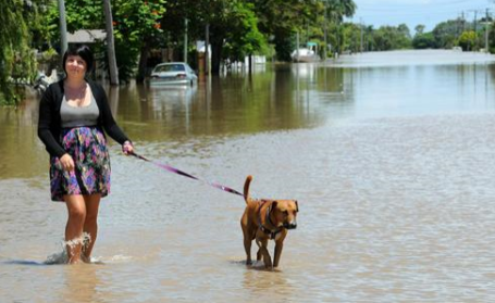
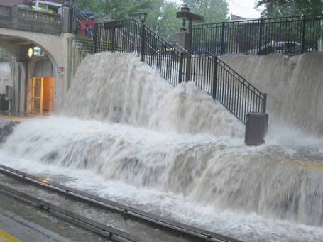
Crocodiles, Snakes A Danger In Australia. Forget about the muddy water - there are living (biting) objects submerged in Australia's floodwaters. From an
article at USA Today: "
ROCKHAMPTON, Australia (AP) — Residents of an Australian city cut off by some of the country's worst flooding in decades are being warned to stay out of the water, and not just because of the risk of being swept away: Debris, snakes and even crocodiles could also pose a danger. Large parts of the coastal city of Rockhampton were under water Tuesday. The waters were still rising, with the 75,000-strong population bracing for the floods' expected peak in the next 24 hours as a huge inland sea spawned by heavy rain across Queensland state drains toward the ocean. Residents on boats made their way through Rockhampton's flooded streets, while police checked houses to see whether they were occupied."
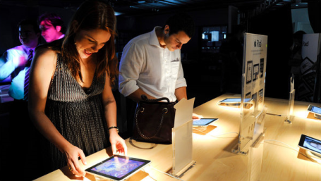
Rivals To The iPad Say This Is The Year. An
article in the New York Times, for anyone holding out for a non-Apple tablet alternative. A new batch are being introduced at CES in Las Vegas later this week, including Microsoft, HP, Toshiba and RIM. An excerpt from the NY Times article: "
Welcome to the year of the tablet. Again. Last year was supposed to be the year manufacturers would wow consumers with offerings of all sorts of tablet computers. Steven A. Ballmer, Microsoft’s chief executive, took the stage in January at the International Consumer Electronics Show, the industry’s premier trade show, and displayed three devices that he said would be on sale in the months ahead. Dozens of smaller companies laid out their own tablet plans at the show."
*
Welcome To The Year Of Tablets and Digital Living Rooms. Another
story for tech-heads from adage.com.
Internet Surpasses Television As Main News Source For Young Adults. You could see this coming, and now it's official. We're all becoming our own news directors, picking and choosing the sources we prefer to get our information. An excerpt from the
story at mashable.com: "
The Internet is now the main national and international news source for people ages 18 to 29, a study from the Pew Research Center reports. In 2010, 65% of people younger than 30 cited the Internet as their go-to source for news, nearly doubling from 34% in 2007. The number who consider television as their main news source dropped from 68% to 52% during that time. Of all 1,500 American adults surveyed, 41% say they get their national and international news from the Internet, up 17% from 2007. Sixty-six percent cite television — down from 74% — indicating the trend is spreading among other age groups."
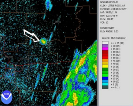
Tracking Birds On Doppler. What killed over 1,000 birds in Arkansas Sunday? NFL football? Boredom? A meteorologist at KATV-TV has a few
theories about what happened that has officials officially stumped.
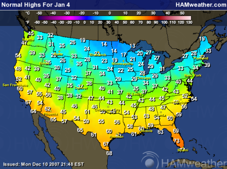
What Happened To "Normal"? Thanks to Ham Weather (a division of WeatherNation) and NOAA, you can see - at a glance - that Tuesday temperatures were roughly 10-15 degrees colder than average across the Upper Midwest. Click
here for more details.
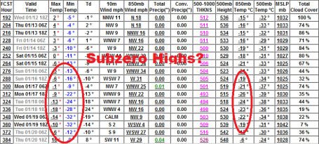
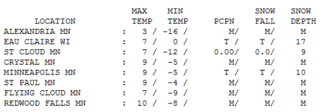
Third Coldest. 9 for a high? Hey, it's still 2 degrees warmer than January 4, 2010, and from what I can tell the third coldest daytime high so far this winter. Hard to believe the average high is 22 degrees. Highs ranged from 3 at Alexandria to 7 in St. Cloud, a balmy 10 at Redwood Falls.
Paul's Conservation MN Outlook for the Twin Cities and all of Minnesota:
TODAY: Light snow likely. Around 1/2 to 1" of snow. Slippery. Winds: NW 10-15. High: near 20
WEDNESDAY NIGHT: Light snow tapers to flurries, little additional accumulation. Low: 4
THURSDAY: Light snow/flurries, coating - 1" High: 15
FRIDAY: Some sun, colder again. Low: -5. High: 12
SATURDAY: Partly sunny, the better travel day of the weekend. Low: 1. High: 17
SUNDAY: PM snow, mainly far southern and southwestern MN. High: 22
MONDAY: Chance of snow (mainly far southern MN). High: 25
TUESDAY: Flurries, colder wind kicks in. High: 21
In Praise of Cold
"Winter must be cold for those with no warm memories," goes a line from the movie, "An Affair to Remember." There are (a few) benefits to a dire lack of kinetic energy: our coldest days tend to sunny. Arctic air is dry, no moisture from nearby oceans. Cold weather correlates with a drop in the crime rate (even criminals feel the wind chill). That, and your garbage doesn't stink.
There's truth to the proverb, "too cold to snow." Although it can snow at any temperature below 32 F, when it's colder than 5-15 F, it usually means the main storm track has been pushed hundreds of miles to our south, limiting just how many inches of snow can fall. Our biggest snowfalls tend to come between 20-30 F.
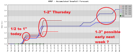
A couple of clippers arrive today and Thursday, an inch of fluff possible each day, just enough powder to grease up highways, turning freeways into a creeping sea of brake-lights. We get a break Friday and Saturday, before the next storm potential early next week. The vast majority of the moisture should pass well south of Minnesota, an "inverted trough" stretching north, producing light snow over southern Minnesota Monday. Yes, it may be "shovel-able" just south of MSP. Stay tuned.
Cloud Atlas: Scientist Maps The Meaning of Mid-Level Clouds. An interesting
story (at least for a hopeless weather geek).
"ScienceDaily (Jan. 1, 2011) — Clouds play a major role in the climate-change equation, but they are the least-understood variable in the sky, observes a Texas A&M University geoscientist, who says mid-level clouds are especially understudied. The professor, Shaima Nasiri, is making those "in-between" clouds the focus of her research, which is being funded by NASA.
Mid-level clouds are so understudied, Nasiri says, that scientists have yet to develop a common nomenclature for them. "We do not have a unified definition, so the scientific community can't look at the statistics with a shared level of understanding. Also, because mid-level clouds are formed either from water droplets or ice crystals or a combination of both, they can be more difficult to model."
Random Video Of The Day. O.K. A friend sent me this link, a homeless man in Columbus, Ohio, definitely down on his luck, but with the most amazing voice I've ever heard. A million dollar voice. This guy should be working. I would LOVE to try and hire this gentleman myself - if I could just track him down. You have to click the You Tube
video to understand what I'm saying. Absolutely amazing, the gift this guy has been given.
Munich Re Warns of Soaring Climate Change Costs. Munich Re is the world's largest reinsurance company, backing up scores of smaller insurance businesses worldwide. An excerpt from an
article at businessgreen.com: "
Munich Re said that 950 natural disasters were recorded last year, nine tenths of which were weather-related events such as storms, floods or heat waves. The total represents the second highest number of natural disasters recorded since 1980 and is 21 per cent higher than the average number of annual incidents recorded over the past decade. Overall, in excess of 295,000 died as a direct result of natural disasters while overall losses reached $130bn (£83bn), of which just $37bn was insured. As a result, 2010 was among the six most loss-intensive years for the insurance industry since 1980."
Munich Re: The Only Plausible Explanation For The Rise In Weather-Related Catastrophes Is Climate Change. An excerpt that caught my eye: "Munich Re’s natural catastrophe database, the most comprehensive of its kind in the world, shows a marked increase in the number of weather-related events. For instance, globally there has been a more than threefold increase in loss-related floods since 1980 and more than double the number of windstorm natural catastrophes, with particularly heavy losses as a result of Atlantic hurricanes.
"The rise in natural catastrophe losses is primarily due to socio-economic factors. In many countries, populations are rising, and more and more people moving into exposed areas. At the same time, greater prosperity is leading to higher property values. Nevertheless, it would seem that the only plausible explanation for the rise in weather-related catastrophes is climate change. The view that weather extremes are more frequent and intense due to global warming coincides with the current state of scientific knowledge as set out in the Fourth IPCC Assessment Report. "There are at present insufficient data on many weather risks and regions to permit statistically backed assertions regarding the link with climate change. However, there is evidence that, as a result of warming, events associated with severe windstorms, such as thunderstorms, hail and cloudbursts, have become more frequent in parts of the USA, southwest Germany and other regions. The number of very severe tropical cyclones is also increasing. One direct result of warming is an increase in heatwaves such as that experienced in Russia this summer. There are also indications of a higher incidence of atmospheric conditions causing air mass formation on the north side of the Alps and low-lying mountain ranges, a phenomenon which can result in floods. Heavy rain and flash floods are affecting not only people living close to rivers but also those who live well away from traditionally flood-prone areas. Although climate change can no longer be halted, even with the help of very ambitious schemes, it can still be curbed." Dr. Peter Höppe, Head of the Geo Risks Research Department at Munich Re, the co-author of Schmidt, Kemfert and Höppe, wrote me: "For me the most convincing piece of evidence that global warming has been contributing already to more and more intense weather related natural catastrophes is the fact that
while we find a steep increase in the number of loss relevant weather events (about tripling in the last 30 years) we only find a slight increase in geophysical (earthquake, volcano, tsunami) events, which should not be affected by global warming. If the whole trend we find in weather related disaster should be caused by reporting bias, or socio-demographic or economic developments we would expect to find it similarly for the geophysical events. By the way the assumption that climate change is increasing the risk of extreme weather events is backed by IPCC." (Thanks for Joseph Romm, Senior Fellow at The Center For American Progress, editor of climateprogress.org).
Finding The Fingerprints of Climate Change In Storm Damage - A Very Long Detective Story. The New York Times Climatewire has an interesting
story about connecting the dots - how difficult it is to say that storm damage was the direct result of excessive greenhouse gases (CO2) in the air. An excerpt: "
Hurricanes could become more prevalent with climate change, but the economic pain they deliver might not be recognized as man-made for 260 years. That means smashed homes and ruined roads may not be attributable to greenhouse gases for centuries, according to new research that suggests climate policies like adaptation should be designed without financial evidence of climate-enhanced windstorms. The researchers also warn environmentalists and policymakers against making claims that damage from Hurricane Katrina and other storms are rising from carbon dioxide emissions. Insurance companies that promote climate change as a reason for rising prices could also lose credibility. The researchers "urge extreme caution in attributing short term trends (i.e., over many decades and longer) in normalized US tropical cyclone losses to anthropogenic climate change."


No comments:
Post a Comment