January is the coldest (snowiest) month of the year. Not sure we'll see more snow than December - but the cold part looks like a given - I don't see any real relief from the biting winds of winter through the third week of January.
Paul's Conservation Minnesota Outlook for the Twin Cities and all of Minnesota:
TODAY: Partly sunny, less wind. Winds: South 8-13. High: 12
SUNDAY NIGHT: Partly cloudy and chilly. Low: 5
MONDAY: PM snow, coating to an inch or 2" possible. High: 19
TUESDAY: Flurries taper. Intervals of sun, colder. High: 8
WEDNESDAY: Patchy clouds, few flurries. High: 15
THURSDAY: Light snow, gusty winds, 1-2" possible. High: 13
FRIDAY: Reinforcing shot of numbing air - intervals of sun. High: 8
SATURDAY: Blue sky returns, light winds, feels like January. High: 16
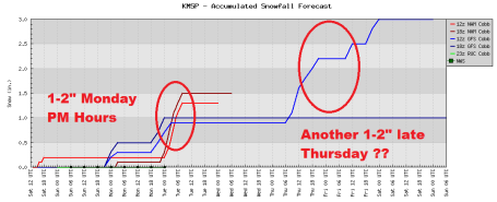
Late Week Snowstorm/Blizzard For New England? The same clipper capable of a quick inch or two of powder here Wednesday night and Thursday will go on to spark another major coastal storm, a possible nor'easter. I don't think it will be as bad as last weekend - but significant snow is possible across much of the northeast late Friday into Saturday.
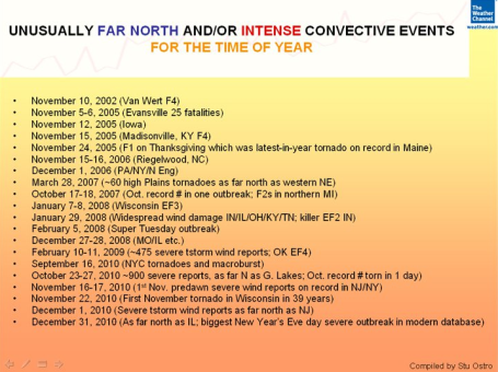
Late Season "Convection". From Stu Ostro at the Weather Channel, a list of some of the unusually strong tornadoes that have struck the USA since November 10. It is a bit odd to be tracking EF-3 tornadoes (at least 3 of them) on New Year's Eve.
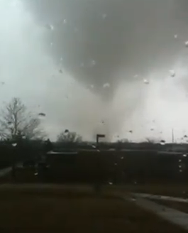
Tornado Swarm. Here is You Tube footage of the tornado (EF-2 or EF-3) that hit Fort Leonard Wood, Missouri, one of at least 26 tornadoes that swept across the mid Mississippi Valley on New Year's Eve.
At Interesting article from the St. Louis Post-Dispatch on the St. Louis Tornadoes, the governor is praising the NWS warnings:
Also, the local STL (LSX) Weather Service office has preliminary Tornado count and damage survey posted, with many photos:
(appears to be at least one EF-3 Tornado that struck southern St. Louis county)
Courtesy of James Aman from Weather Bug
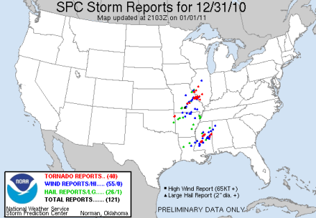
New Year's Outbreak. SPC is reporting 40 tornado reports on New Year's Eve. To see details on each one click here.
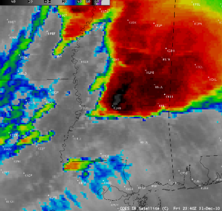
Too Close For Comfort. From the U. of Wisconsin CIMSS weather blog - reports of a tornado that hit the airport at Jackson, Mississippi Friday - causing the local National Weather Service staff to scramble for cover! "A tornado moved directly across the southern portion of the airport runway at Jackson, Mississippi (station identifier KJAN) around 23:20 UTC on 31 December 2010 — being such a close call, it was cause for the staff at the National Weather Service forecast office at Jackson to shelter in place for several minutes while the tornado moved over the airport. AWIPS images of 4-km resolution GOES-13 10.7 µm IR data (above) showed the cold cloud top IR brightness temperatures associated with the storm, which reached a minimum value of -77º C at 22:10 UTC."


Extended Outlook
My long range forecast? "Changeable". I stand by that. "Partly to mostly with a chance." Only the brave and foolish attempt a forecast beyond a week. With that caveat, let's go out on a shaky limb and make predictions for 2011. Based on current trends expect more snow than average (55-65" seems realistic). Severe spring flooding appears imminent, especially Red River. More flash floods, warmer nighttime lows, more summer humidity, in all probability another busy tornado year (but nowhere near the 104 tornadoes we endured in 2010). Drought? I don't see it - the trend is toward a stormier, wetter pattern. Our weather has always been volatile, but there's little doubt the frequency and intensity of extreme weather is on the rise. No, you're not imagining it.
No big storms are brewing, a clipper squeezes out a quick 1" of powder Monday night. A reinforcing surge of Arctic air whips up 1-2" more snow Thursday (and what may be next blizzard for New England next weekend). A cold week's on tap (we got our "January Thaw" last week). Which leads me to my last ill-advised forecast: based on La Nina there's little doubt that January '11 will be colder than average. That's a stretch, huh?

"The Chinese Will Be Eating Our Lunch." An interesting story from redgreenandblue.org:
"The good news: There’s one GOP representative that knows climate change is real, and says we have to do something about it. The bad news: He lost his Republican primary to a Tea Party-backed candidate who will take his place in Washington next week. “To my free enterprise colleagues, whether you think it’s all a bunch of hooey, what we talk about in this committee — the Chinese don’t, and they plan on eating our lunch in the next century, working on these problems,” Representative Bob Inglis (R- SC) told his House colleagues. “We may press the pause button for a few years, but China is pressing the fast-forward button.”
No comments:
Post a Comment