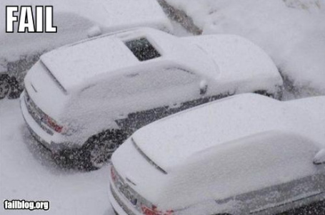
55.4" so far this winter in the Twin Cities (24.5" more than average as of January 23).
3: number of days without snow in January.
3.5: number of degrees below average for January temperatures in the Twin Cities.
9: number of subzero nights in the Twin Cities this winter.
12: inches of snow on the ground at KMSP this morning.
16: number of days this winter with an inch or more of snow in the metro area.
52: number of days with at least a "trace" or more of snow so far at KMSP this winter season.
4,159: heating degree days since July 1, according to the National Weather Service. Average as of January 23 is 4,333 HDD. That means we've used 4% less energy to heat our homes and offices since temperatures started to drop last autumn. Put another way, the '10-'11
heating season is running roughly 4% warmer than average. I know. I did a double-take too. True, it has been colder than average since December 1 (December was 2.3 F colder than average, January is 3.5 degrees colder than the running 30-year average) but last autumn was considerably milder than average across Minnesota. An earlier statement I made that "
winter is running warmer than average" is absolutely incorrect - we've been consistently colder than average since the start of meteorological winter in early December.
Snowfall So Far This Season:
Boston: 50" (average as of today is 41.5"). The Big Apple spent $40 million cleaning up from just one (1-2 foot) snowfall the day after Christmas.
New York City: 36" (average as of today is 21").
Atlanta: 6" (average is closer to .3"). Atlanta spent $10 million removing the 3-5" that fell nearly 2 weeks ago.
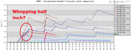
Nuisance Snow Today. Models are unanimously killing today's clipper - printing out a coating to (maybe) a whopping half inch of slush, one outlier closer to 1". With air temperatures in the mid 20s to near 30 by late afternoon most freeways/interstates will be wet and slushy.
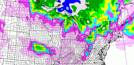
A Relatively Quiet Week. Today's clipper may put down as much as 3-5" over far northern Minnesota, north of Duluth, near the BWCA and Grand Marais. More lake-effect snows are expected, but I don't see any widespread snow/ice- related delays through the end of the week east of the Rockiest....for a change.
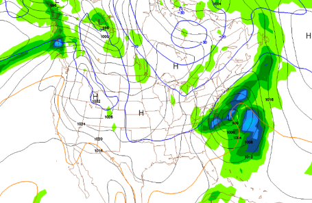
Steering Out To Sea. The next coastal storm out east is now forecast to remain just offshore, brushing the Carolinas with a rain/snow mix, but any heavy snow bands should remain east of D.C., New York and Boston. Good news for travelers. This GFS forecast map is valid 7 pm Wednesday evening.
Not Quite Out Of The (Bitter) Woods Just Yet. Round 1 came in early December (3 subzero nights). This latest outbreak (4 subzero nights/row) will ease today as temperatures spike close to 30 (above!) A relatively mild week is on tap, followed by a colder swipe next weekend. The GFS is hinting at another pretty good shot of Arctic air after Saturday, Feb. 5. It may not be quite as cold as this latest outbreak, but close.
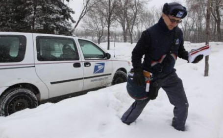
So You Think Winter's Been Bad? The Star Tribune's Kristin Tillotson has a good
article focusing on people who have it REALLY bad, trying to navigate the cold and snow every day just doing their jobs. Here's an excerpt: "
When it comes to trekking around our frigid, snow-saturated cities this winter, misery does love company -- and has plenty of it. Everybody's having a hard time getting around, but some have to deal with it throughout their entire work shift. Plenty of folks have jobs that keep them out in the clogged, slippery streets -- bus drivers, emergency medical technicians, highway salters/plowers, long-haul truckers, pizza deliverers, mail carriers and newspaper deliverers, to name a few."
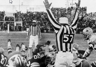
The "Ice Bowl". December 31, 1967. You thought yesterday's AFC and NFC Championship games were "cold"? Hardly, at least compared with the very definition of a cold game, the "Ice Bowl" played between the Packers and the Cowboys on December 31, 1967. From the National Weather Service: "The 1967 NFL Championship Game between the Dallas Cowboys and the Green Bay Packers, played on December 31 at Lambeau Field, is known as the Ice Bowl, arguably one of the greatest games in NFL history.
The game was played in brutal cold and windy conditions. The kickoff temperature in Green Bay was -13 F, with a wind chill of 36 below zero. Temperatures were so cold, in fact, that referees had to shout signals so that the metal whistles wouldn't stick to their lips. Even so, nearly 51,000 fans watched the coldest game in league annals.
Several players were treated for frostbite and a fan in the stands died of exposure to the cold.
Bart Starr, the Green Bay Packers Hall of Fame quarterback, scored the game-winning touchdown with 13 seconds remaining, clinching a third straight NFL Championship for the Packers.
Some Interesting Ice Bowl Weather Facts
- The coldest and longest cold stretch (nine days) during the 1967-1968 winter season began the day of the Ice Bowl. Seven of nine days during that stretch did not exceed 0 F.
- The winter in which the Ice Bowl was played (1967-1968) ranked 2nd all-time for the least snowiest (20.6 inches). The record is 19.2 inches during the winter of 1960-1961.
- The Ice Bowl ranked 1st all-time for the lowest average temperature for any December 31: minus 6.5 F for the day.
- The Ice Bowl ranked 1st all-time for the lowest minimum temperature for any December 31: -19 F reached just before midnight that evening.
- The Ice Bowl ranked 4th all-time for the lowest maximum temperature for any December 31: + 6 F reached at midnight early that morning.
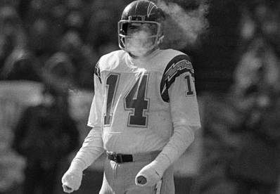
America's Coldest Football Games. What is it about championship games and bitter weather? The photo above is from the Bengals - Chargers game at Riverfront Stadium in Cincinnati on January 10, 1982. Air temperature: -9. Wind chill: -59. One of a handful of games included in a terrific Forbes article focusing on
America's Coldest NFL Games.
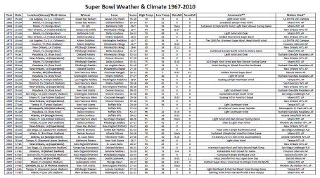
Superbowl Weather Since 1967. Thanks for meteorologist D.J. Kayser for tracking down the Mother Lode of NFL/Weather factoids and trivia. A few
fun facts from NOAA's Southeast Regional Climate Center:
13 of 44 Bowls Played indoors.
16 of 44 Bowls had a Trace or More of Rain at nearby AP.
2 Bowls had Snow on Game Day (1982,2006).
1 Bowl played during an Ice Storm (2000).
Warmest High Temperature of 82° (1973,2003).
Coldest High Temp for Dome Game 16° (1982).
Coldest High Temp for Non-Dome Game 43° (1972).
Wettest Super Bowl .92 inches (2007).
Outside Games With High Wind Gust (1980, 1984, 1989,2007).
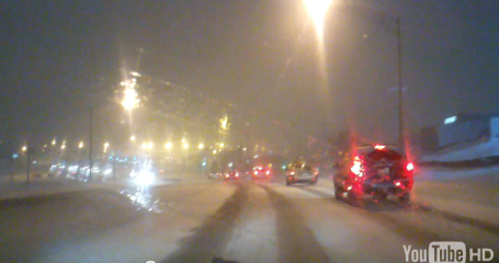
"Snow-maha." One upside to bitter cold? These Arctic invasions tend to shove the main highway for (heavy) snow well south of Minnesota. St. Louis picked up a cool foot of snow on Friday, and
Omaha has been in the path of some of these recent storms. The You Tube video was shot on an Android phone, by the way.
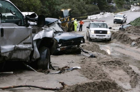
California's "Big One" Might Be A Superstorm. I included a similar article a few weeks ago - this story is getting a lot of traction, especially in California, as you might suspect. The L.A. Times
reports: "California's "big one" may not be an earthquake at all, but a devastating megastorm that would inundate the Central Valley, trigger widespread landslides and cause flood damage to 1 in 4 homes in the state. The prospect of such a storm was raised this month by scientists predicting the consequences of an "atmospheric river" of moisture from the tropical Pacific hitting California with up to 10 feet of rain and hurricane-force winds over several weeks. A team of more than 100 scientists, engineers and emergency planners used flood mapping, climate change projections and geologic flood history to simulate a hypothetical storm so intense that it occurs only every 100 to 200 years.
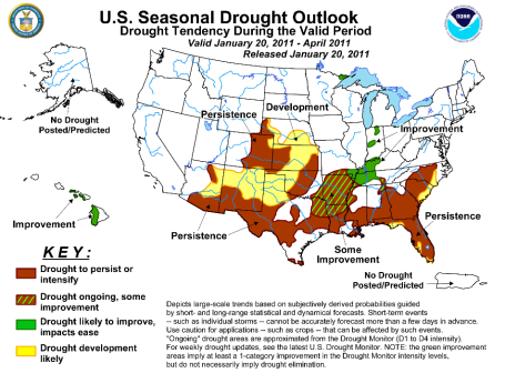 Persistent Drought Over Southern USA
. Major storms have made the news, so it's somewhat surprising to hear that drought conditions are continuing over roughly the southern third of America, from the Carolinas and much of Georgia westward to Texas and New Mexico. More from NOAA
here.
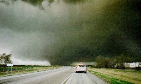 An Active Tornado Season?
 Considering we have a strong La Nina (which will probably linger into part of the spring), the odds of a more active tornado season for the Plains and Upper Midwest are statistically higher than average. There are numerous papers linking a cooling phase of the Pacific with increased frequency of tornadoes east of the Rockies. 2008 was a La Nina year - with a subsequent uptick in tornadoes, as described in
this article. I can't imagine a scenario where Minnesota would see more than 104 tornadoes (the number of confirmed touchdowns in 2010), but La Nina spring tend to spawn more numerous violent, long-lasting EF-3 and stronger tornadoes. We'll see.
Twin Cities Events. If you're looking for something to do to get out of the house (and get out of a mid-winter funk) check out KARE-11's
Metromix site - lot's of great ideas and a useful calendar feature to help you get a handle on what's going on in the near future.
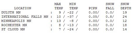
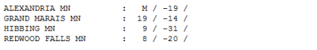
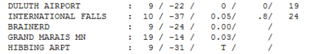
Sunday Numbers. Our -8 F. low looks almost reasonable compared to International Falls (-37) and Hibbing (-31). Brainerd woke up to -24 F. Sunday morning, all reporting stations recovering into single digits and teens for highs.
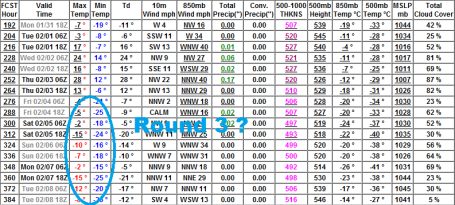
 Paul's Conservation Minnesota Outlook for the Twin Cities and all of Minnesota:
TODAY: Light snow, flurries. Coating to 1/2" possible. Winds: W 10-15. High: near 30
MONDAY NIGHT: Flurries taper, little or no additional accumulation. Low: 3
TUESDAY: Intervals of sun, better travel. High: 23
WEDNESDAY: Mix of clouds and sun, not bad. High: 22
THURSDAY: Fading sun, milder Pacific breeze kicks in. High: 28
FRIDAY: A fleeting thaw? Mild start, then windy, turning colder PM hours. High: 31 (falling by afternoon)
SATURDAY: Flurries, bitter breeze returns. Low: 9. High: 13
SUNDAY: Blue sky, numb again. Low: -5. High: 4
"Ice Bowl"
Yesterday's NFL playoff games reminded me of the "Ice Bowl", on December 31, 1967. I was 9 years old, but remember it vividly. The Cowboys were playing the Packers at Lambeau Field in Green Bay; a game-time temperature of -13, windchill: -36. It was so cold the referees had to shout signals so the metal whistles wouldn't freeze to their lips. Players had to be treated for frostbite; a crowd of 51,000 braved the elements, one fan died from exposure. A Bengals game played in 1982 at Riverfront Stadium in Cincinnati had a chill factor of -59! More useless football/weather trivia at my weather blog.
Good news on the weather front. Today's clipper has fizzled, a snowy coating to 1/2" possible. The next chance of a couple inches? Early February. The BIG news: our much-rumored warm front is still on the way this week. Today and Thursday your brain-freeze will ease, you'll even regain some feeling in your nose and toes. Both days you may eye your grill and shed a few layers, as temperatures near 32 F. Anywhere else in America a forecast of "freezing" would be greeted by gasps & a sense of foreboding. Here we exhale, relieved that things are "finally turning around." One more big reason to love "Minne-snowda."
Looking Back at 2010: Are Accelerating Weather Extremes A Symptom Of Climate Change? Gary Betts, climate scientist and commentator, had a few thoughts for
Vermont Public Radio which I thought were worthy of sharing: "
The Earth's climate system, which is rather unstable, is being driven by the increase in greenhouse gases and the warming of the Arctic into new patterns, and these are giving us new extremes of weather. Climate change is forcing us to face something that nobody wants to face. It is now widely acknowledged that our industrialized world, created by science and technology and a market economy, is polluting the atmosphere and oceans; and driving rapid climate change. We now face the paradox that although humanity is responsible for this; the longer we delay in changing direction as a society, the more the Earth system is slipping beyond our control. Climate scientists have been issuing warnings for twenty years, and every year our understanding of the Earth improves; so we can better estimate the climate risks we face. But there is a naïve assumption that our politicians will use this valuable information to redirect the economy away from fossil fuels, and so steer us away from the looming precipice of irreversible climate change. But in fact, politicians will say and do almost anything to avoid responsibility for difficult and painful decisions. So at the national level our paralysis has deepened." Image courtesy of Stu Ostro, forecaster at the Weather Channel.
Climate Change: Dogs Of Law Are Off The Leash. Are lawyers chomping at the bit for class action lawsuits, taking on some of the biggest greenhouse gas polluters? It's still early, but some analysts believe such suits are inevitable, and that's why so many energy providers are nervous, putting up a valiant attempt to deny/delay the science. From an
article at MSN News: "
Compensation for losses inflicted by man-made global warming would be jaw-dropping, a payout that would make tobacco and asbestos damages look like pocket money. Imagine: a country or an individual could get redress for a drought that destroyed farmland, for floods and storms that created an army of refugees, for rising seas that wiped a small island state off the map. In the past three years, the number of climate-related lawsuits has ballooned, filling the void of political efforts in tackling greenhouse-gas emissions. Eyeing the money-spinning potential, some major commercial law firms now place climate-change litigation in their Internet shop window. Seminars on climate law are often thickly attended by corporations that could be in the firing line -- and by the companies that insure them."
The World Is Warming And Waiting For Science. An excerpt from a recent
story from the Orlando Sentinel: "
As Thomas notes, record-breaking cold temperatures in parts of the northern hemisphere have provided easy fodder to those who deny the earth's climate is changing. A closer look at recent scientific investigations will reveal these cold-weather extremes are induced by anthropogenic warming. Rising Arctic temperatures and concomitant sea-ice loss alter the northern-hemisphere jet stream and, on occasion, force cold air toward the southern U.S. instead of western Eurasia. The fact is the year 2010 tied with 2005 as the hottest year for the planet in more than 130 years. Each of the past three decades has been hotter than the one before, and during that time, there have been twice as many record-high temperatures than record lows in the U.S."
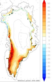
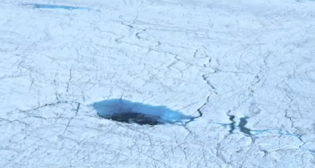
2010 Meltdown of Greenland. The Cryospheric Processes Laboratory at the City College of New York reports that, in 2010, some areas of Greenland saw a melting season 50 days longer than average. "
Remote sensing data, surface observations and models indicate new records in 2010 for surface melt and albedo, runoff, the number of days when bare ice is exposed and surface mass balance of the Greenland ice sheet. This was especially true over its west and southwest regions. Melting is a crucial factor in both surface and subglacial processes. Here's a video showing melting streams, supraglacial lakes and meltwater flowing through ice cracks that we recorded in 2009 and 2010."
Climate Change Fastest In Southeast Asia. An
article from AsiaOne News: "
A re-insurance giant has released a study that says that South-East Asia will be feeling the effects of climate change faster than any other region. This was due to the number of natural disasters that have struck the region over the past decade. Although South-East Asia had been feeling the full effects of flobal warming in the past century, the sharp increase of natural disasters from 100 to 300 annually was evidence of that. Ernst Rauch, Much Re's head of corporate climate centre, told the Sunday Times that warming temperatures were the clearest sign of climate change. Large land masses which surrounded the region, such as India and China, contributed to temperatures rising at a faster rate, he said. Munich Re has calculated total financial losses from natural disasters such as floods, earthquakes and storms in Asia at around $1.4 billion. 1.14 million lives were lost in Asia alone last year."
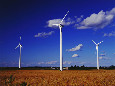
Energy For The Economy. The New York Time's Andrew Revkin (author of the Dot Earth web site) has a thoughtful
editorial about what President Obama might be able to do to get a conversation going about next-generation energy needs during Tuesday's State of the Union address: "
Mr. Obama’s first step should not be to announce a predetermined list of policies to transform our energy system, but to use his State of the Union address to commence a yearlong American conversation on the merits and shape of such an effort. Modeled on the president’s health care summit meeting last February, this conversation would play out in public televised events attended by the president or his cabinet, along with politicians, experts, scientists and American workers, in places ranging from the White House to coal country, from the grounds of a potential site for a new nuclear reactor to the boiler room of a primary school looking to cut emissions and energy bills."

No comments:
Post a Comment