60.4" snow so far this winter.
Trace of snow so far in February
8.2" average February snowfall at MSP.
10.4" average March snowfall at MSP.
3.1" average April snowfall at MSP.
73% odds of getting smacked if you mention the April snow statistics in a public place. Keep this between us. And realize that even if/when it snows in March or April, it's gone within 12-24 hours.
37 days/row below 32 F. in the Twin Cities (the last time we experienced a true thaw was back on December 29).
66 days/row below 32 F. - the modern-day record in the Twin Cities, according to Pete Boulay at the MN State Climate Office. Details here.
Storm Trivia:
* At 10 am Thursday it was warmer in Fairbanks, Alaska (13 F) than it was in Oklahoma City (7 F).
Record Lows Wednesday (courtesy of EarthNetworks)
Tulsa, OK -1
El Paso, TX 6
Goodland, KS -13 (tie)
Borger, TX -2
Clayton, NM -13
Record Lows Thursday
Tucson, AZ 18
Alamosa, CO -31
Chanute, KS -16
Kansas City, MO -12 (tie)
Springfield, MO -9
Joplin, MO -11
Fayetteville, AR -5
San Angelo, TX 14 (tie)
Tulsa, OK -6
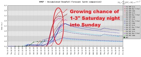
Sunday Clipper. The arrival of the next cold surge will set off a couple inches of snow late Saturday night into Sunday, possibly enough to shovel/plow. Data from the NAM model output.
Trending Snowier. All the models are in fairly good agreement for accumulating snow Saturday night into Sunday as the next push of Canadian air reaches Minnesota: low 30s Saturday to single digits by Monday will spin up a period of accumulating snow. Range? 1-3" seems like a pretty good range right now.
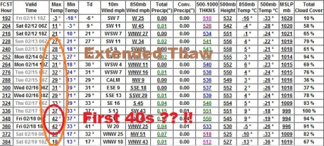
First 40s of 2011? Too early to get excited, but the 00z GFS model has been trending milder for the third week of February, an entire week at or above freezing - and maybe, just maybe, the first 40s of the season around Feb. 18-19. We're due for a thaw, come to think of it. The mercury has been below 32 F. since December 30 in the Twin Cities.
This Winter's Plethora Of Events. I just wanted to work "plethora" into today's weather blog. The local Chanhassen NWS does a nice job
recapping all our significant snow events since early December.
Chicago Recap. From Jim Allsopp at the National Weather Service in Chicago - a terrific
summary of Chicago's biggest snowstorm since 1979: "
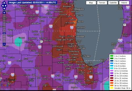
Northern Illinois and northwest Indiana were walloped by one of the most powerful winter storms in history on February 1 and 2, 2011. Snowfall totaled 20.2 inches officially at Chicago’s O’Hare Airport, making it the third largest snowstorm on record. The total at Rockford was 14.3 inches, which is fourth on the all time list. The snowstorm was accompanied by fierce winds, gusting to 50 to 60 mph. The intense winds and heavy snow reduced visibility to near zero at times and produced widespread snow drifts of 2 to 5 feet, and a few drifts of 10 feet or more. The storm was powerful enough to generate vigorous updrafts, resulting in lightning, thunder, and small hail."
(I can't remember a storm where heavy snow, the result of strong upward motion, was accompanied by hail, which is triggered by violent updrafts within embedded thunderstorm updrafts). Amazing.
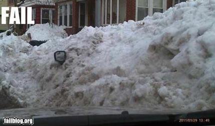
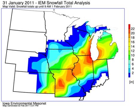 Storm Totals
. Widening out the view gives you even more respect for the sheer volume of snow that was dropped on the Midwest and Great Lakes, a huge swath of 1-2 foot amounts, whipped into 5-10 foot drifts. Map courtesy of the Iowa State Agronomy Department - get a closer look
here.
Groundhog Day Blizzard of '11 Recap. Here's a good
overview of the blizzard that shut down Chicago (and much of the Upper Midwest) earlier this week, from the CIMSS Weather Blog at the University of Wisconsin: "
This was a particularly large storm, impacting a swath of the US over 2500 miles long and 700 miles wide with snow, sleet, and ice from New Mexico to Maine — snowfall amounts were as high as 27.0 inches at Antioch, Illinois."
A Harrowing Midwinter Tale. Courtney Allar is our Office Manager here at WeatherNation. Her sister in law's sister lives and works in Chicago, and this story to tell about the wild storm that just struck the Windy City: "
I left work at 3:30, and got on Lake Shore Drive (LSD) at 4:30. At first we were moving very slowly, but then it got progressively worse, as the wind picked up and the snow increased. I finally stopped moving at around 7 p.m. I saw a couple of people leaving their cars, but I don't know how they did it. The couple of times that I got out to scrape my windshield, or talk to the car in front of me, I didn't last longer than a minute. The wind was so strong, and it was blowing water and snow from the lake, so I became wet after going outside and I could barely see because of the white-out conditions. My car was shaking from the wind the whole time, and there was also thunder and lightening periodically. 3 firefighters walked by throughout the evening. The first one just checked to see if I was OK. A couple hours later, another one said warming buses were on their way, and we would probably be stuck in our cars until morning. The last firefighter came around 2:30 a.m. and said that fire trucks were on their way to evacuate people in cars. A little after 3, the fire trucks came. There was a drift that I had to push through to open my door, and my car was covered in ice from the lake. They brought us to a hospital, and it was so strange how much better it got once we were off LSD. The visibility was so much better, and it was not nearly as windy or snowy. People were advised to either find a ride, or sleep at the hospital. I called Aaron to see if he could come, but he was unable to get his car out. One of the firefighters heard me talking to him, and quietly asked me where I was headed (he didn't want the other stranded people to hear him and get upset!). Berit and Aaron only live 5 or 6 blocks from the hospital we were at, so he asked the other firefighters if it was OK to drop me off. They agreed, so I was very lucky to get a secret ride in the fire truck! The other issue was finding my car. LSD was closed for a day while they towed all of the cars to lots close by the exits. I called the city numerous times, but my car was not listed in the system, so I had no way of knowing where it was. So, I just started driving to the locations where the cars were. While I was looking in one of the lots, all of the Chicago news stations were there, and NBC interviewed me since my car wasn't listed in the system. There were a lot of frustrated people wandering around. After 4 tries, I finally found it. There was snow under the hood, and it had to be jump started, but now it's running fine! Who knew??? My '95 Toyota Celica really pulled through :). "
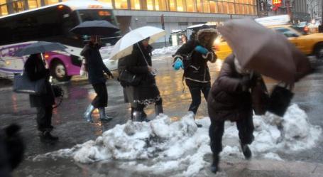
As Much Of The Nation Digs Out, A Freeze Sets In. An
update from the New York Times "
Out went the blizzard, and in came the deep freeze. As Chicago awoke to the task of clearing up from the third biggest snowfall in its history — a monster of a storm that smothered the city in 20.2 inches of snow, stranded drivers on Lakeshore Drive and gave children their first snow day in a dozen years on Wednesday, and then again on Thursday — the temperature plunged to a bone-chilling zero degrees. And it was not alone: dozens of states from Texas to Wisconsin saw the snow and ice stop falling, only to be replaced by a cold snap."
Who Is To Blame? Much of America east of the Rockies is shivering, shoveling, griping about the weather. We all love a scapegoat. The New York Times
asks the (ridiculous) question: Who is to blame for this weather? "
This week, 70 percent of the country was looking at snow. Florida is the only state that has not seen snow this winter. But Florida has gotten icicles in the orange groves plus a new governor whose claim to fame was running a corporation that cheated the federal government out of enormous amounts of money. Florida’s not feeling all that superior. Chicago’s snowfall was so huge that the news media ran out of things to attach to “snow” — thundersnow! snowpocalypse! snowmageddon! The storm beat the world-famous blizzard of 1979. Really, if you’re going to be cold and miserable and inconvenienced, you might as well be setting a record..."
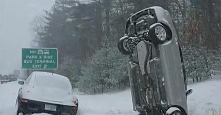
Snowzilla! This is a great summary of the weather-madness gripping the USA in recent days, everything from thunder-snow to cars doing head-stands. CNN's Jeanne Moos
reports.
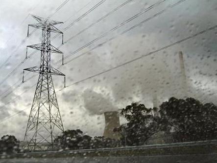
Mexico Provides Electricity For Wintry Texas. From
Yahoo News:
"MEXICO CITY (AFP) – Mexico's state electricity company on Wednesday started supplying electricity to the US state of Texas, where demand shot up amid unusually cold temperatures and caused power outages. Mexico's Federal Electricity Commission "was determined to support Texas with electrical energy faced with the problems the state is suffering due to climatological conditions," a statement said. An energy transfer of 280 megawatts began at midday (1800 GMT) via the north Mexican border cities of Nuevo Laredo, Reynosa and Piedras Negras, it added."
Record Snowfall Amounts for Wisconsin:
Kenosha: (27.3")
Racine: (26")
Burlington: (20")
Stoughton: (19.1")
How Did Forecasters Get This Storm So Wrong? The prediction for Syracuse was for well over a foot of snow, but in the end the storm fizzled out. I feel bad for the meteorologists in upstate New York who depended on the computer models for their predictions. Unfortunately,
syracuse.com is not in a forgiving mood: "
Ithaca, NY -- How on earth did forecasters miss by so much? Wednesday was supposed to bring a “monster storm” with more than a foot of snow. But it was rain showers, and not much of those, that met morning commuters. “It was too powerful,” said State Climatologist Mark Wysocki. The storm was so strong, he said, that it wound itself up and drew in warm, dry air from Texas, New Mexico and northern Mexico. That air weakened the storm in the Northeast and turned what was expected to be snow into sleet and rain. “It shut itself down,” Wysocki said. Wysocki, a lecturer at Cornell University, said he could see the storm changing dramatically between 11:30 p.m. Tuesday and midnight when high-level winds were blowing harder than predicted and the type of precipitation actually showing up on the ground in Pennsylvania was rain, not snow. “You’d like to pull everything back you said earlier in the day and tell everybody it’s not going to be so bad,” he said. Schools were closed, churches canceled programs and one court delayed a murder trial based on forecasts that made it sound like the region would be buried in snow. Forecasters look to computer forecast models, Wysocki explained, and those models – there are three that are widely used – are run only twice a day and compute based on information from a limited number of sites. For instance, weather balloons are launched twice a day at weather stations in Buffalo, Albany and on Long Island. A weather disturbance above Syracuse or Oswego or Binghamton doesn’t get detected by the balloons."
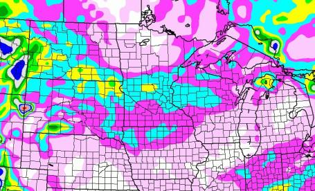
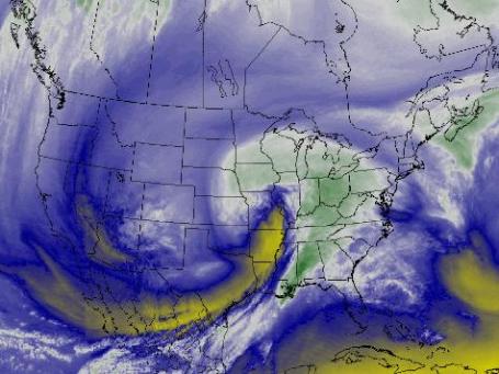
The Big Chill - Much Of North America Covered In Snow And Ice. Graphic courtesy of NOAA.
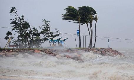
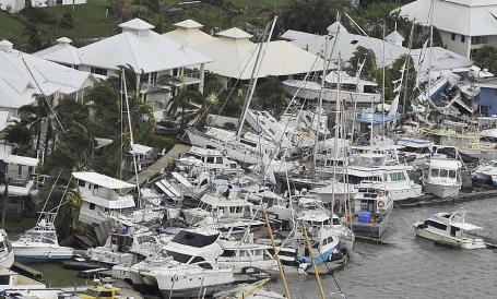
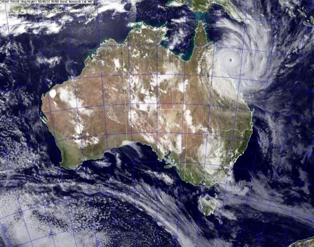
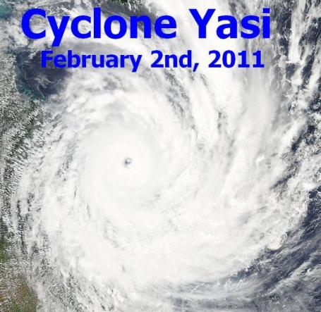
Aftermath. Cyclone Yasi struck Queensland, Australia as an extreme Category 5 hurricane, as strong as they ever get, with sustained winds over 150 mph and gusts close to 180 mph. The
Brisbane Times has some photos of the aftermath - it's a minor miracle (and a testament to Australia's Weather Bureau and warning system) that there wasn't a massive loss of life with this historic storm.
Cyclone Yasi To Cost Insurers AUS $3.5 Billion. It appears that "Yasi" was the most damaging cyclone (hurricane) to hit Australia since "Tracy" came ashore near Darwin in 1974. More from
Reuters: "
One of the world's most powerful cyclones which battered Australia's northeast coast on Thursday is expected to cost insurers around AUS $3.5 billion, according to Forecasting service Tropical Storm Risk (TSR). Cyclone Yasi, roughly the size of Italy, was rated a maximum-strength category five storm, and drew comparison with Hurricane Katrina, which wrecked New Orleans in 2005, killing 1,500 people and causing $81 billion in damage. Cyclone Yasi will be the second most damaging Australian cyclone on record after cyclone Tracy which struck Darwin in 1974, TSR told Reuters on Thursday. "Based on Yasi's immediate post-event windfield and TSR's high resolution loss model we are looking at a total insured damage bill of about AUS $3.5 billion," said Professor Mark Saunders, TSR's director. Yasi made landfall near to Mission Beach in northeast Queensland at around 14:00 GMT on Feb.2 with peak 3-sec gusts of about 170 mph. Yasi is the most powerful cyclone to strike the east coast of Australia since 1918, said the forecaster."
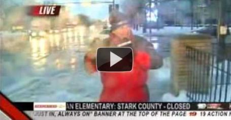
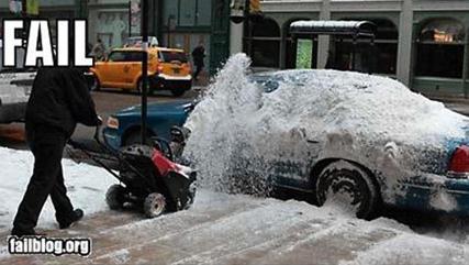
One Sloppy Live Shot.
In Cleveland, WOIO-19-CBS meteorologist Jon Loufman did his best Anderson Cooper impersonation, standing next to a slush-filled street, then acting shocked...shocked, I tell you... when he was doused by a passing car. "Oh, my goodness. I just got hammered, guys," he said, moments before filling out an application for a local Emmy. "Can you get a shot of me? This is worth at least a shot. Oh, man, did I just get hammered." Oh, man, I'm out in the middle of this mob and I'm getting pushed and shoved and, 'Hey, can you get a shot of me?"
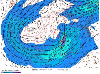
Megastorm of Feb. 1, 2011. Why No Tornado Outbreak? From meteorologist and severe storm specialist Jon Davies' blog: "
The big storm on Feb. 1st that affected much of the central U.S. and Midwest with blizzard conditions and massive snow (see photo above of snow shoveling pile at my house N of Kansas City) was quite a news maker, with several deaths blamed on the dangerous conditions. Often, such strong winter systems (in this case, an intense negative tilt wave moving northeastward out of a large trough, see 500 mb chart above) plow up enough moisture, wind shear and lift to generate an outbreak of tornadoes somewhere in the southern U.S. near the Gulf coast. I heard meteorologists on TV mention the "T" word as a possibility in the Deep South several times as this storm intensified. But so far, only 3 weak/brief tornadoes have been reported where several tornado watches were issued. Why the lack of tornadoes on the south end of this intense system?"
Many Basic Weather Tools, But No Great Ones. The New York Times tech wonks
bemoan the lack of any (amazing) weather apps: "
Strange but true: four years after the iPhone’s debut, software developers and media giants have yet to build a truly great weather app. Mobile apps will give you weather reports and forecasts for your ZIP code, but beyond that, things get dicey, even for more expensive ones like the Weather Channel’s Max for the iPhone ($4). On Sunday, for instance, when Max forecast Tuesday’s snowstorm, it did not mention the one thing anyone would want to know: expected accumulations. So for those looking to load their phone with state-of-the-art software to help navigate the season’s next storm, it helps to start with low expectations."
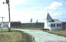
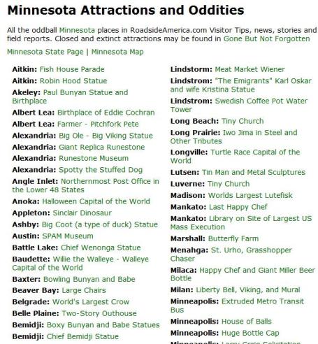
Tiny Church In Luverne, Minnesota. Looking for something to do this weekend? I stumbled upon a pretty cool site,
roadsideamerica.com, that lists some of the (stranger, more curious) attractions around the USA. Think you know Minnesota? Check out the site to see some of the more...unusual attractions in our great state. From the web site: "
Tiny church that seats 4 people. It is located 2 miles north of Luverne, MN on US Hwy 75, near the Blue Mound State Park. I grew up near here, and visited it many times. It used to have a giant fiberglass turkey next to it, but that has since been moved to a farm farther north near Pipestone, MN. [Todd Berger, 12/22/2003]"
For iPhone, Almost Heaven. Mindless rants of an Apple fanboy? Guilty as charged. The iPhone interface, the way it looks, feels and WORKS is top-of-the-line, and I've had way too many cell phones in the last 10 years. An embarrassing number of cell phones. For the record, I also have an HTC Incredible running Android, which I like, but don't love. One big reason: the Android app store is a holy mess. There are a lot of (crappy) apps that shouldn't be there. You can complain about Apple being the Orwellian Gatekeeper 'til you're blue in the face, but the truth: they don't let substandard apps into their store. The overall user-experience Is. Just. Better. One guy's opinion. Apparently David Pogue
agrees, especially with Verizon's soon-to-be-released iPhone: "
It’s here. After almost four years of speculation, the iPhone will finally come to Verizon's network on Feb. 10. And to answer everyone’s question, the Verizon iPhone is nearly the same as AT&T's iPhone 4 — but it doesn’t drop calls. For several million Americans, that makes it the holy grail. I took the Verizon iPhone to five cities, including the two Bermuda Triangles of AT&T reception: San Francisco and New York. Holding AT&T and Verizon iPhones side by side in the passenger seat of a car, I dialed 777-FILM simultaneously, and then rode around until a call dropped. (Why that number? Because I wanted to call a landline, eliminating the other person’s cell reception from the equation. Also, Mr. Moviefone can carry the entire conversation by himself, so I could concentrate on the testing.)"
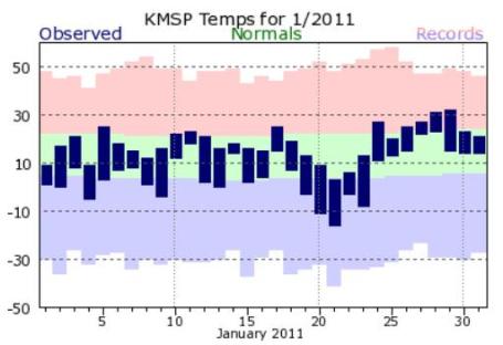
January Recap. 17" of snow in the Twin Cities last month, about 3.5" more than average. Surprisingly, temperatures for the entire month were only 1.1 F colder than the rolling 30-year average (which amazed me). Again, I think the massive piles of snow made it FEEL a lot colder than it really was. The NWS has a summary of January weather for a number of cities in Minnesota and Wisconsin
here.
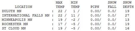
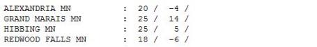
Heading In The Right Direction. Under a sunny sky the mercury reached 19 in the Twin Cities, just 6 degrees below the average high of 25. 13" of snow on the ground in the Twin Cities, 16" at St. Cloud, 19" Rochester and a whopping 27" at International Falls.
Paul's Conservation Minnesota Outlook for the Twin Cities and all of Minnesota:
TODAY: Flurries, coating possible late. 1-2" near Duluth. Winds: SW 10-20. High: 31
FRIDAY NIGHT: Light snow and flurries - a few slick roads. Low: 25
SATURDAY: Mostly cloudy, dry most of the day. High: 32
SATURDAY NIGHT: Light snow develops. Low: 20
SUNDAY: 1-3" snow possible, slippery spots as temperatures start to fall. High: 25
MONDAY: Gray, much colder with flurries giving way to PM sun. Get me out of here! Low: 0. High: 8
TUESDAY: Blue sky returns, "cold enough for me". Low: -6. High: 9
WEDNESDAY: Reinforcing cold front, few flakes in the air. Low: 2. High: 14
THURSDAY: Coldest day of the week. Some sun. Low: -8. High: 6
A "Dry Cold"
One of my favorite rationalizations from friends living in Phoenix: "It's a dry heat!" So is my oven, but I wouldn't want to stick my head inside. Two benefits of living in the Land of 10,000 Cold Fronts? 1). Our coldest days tend to be sunny, which helps on some level, and 2). A lack of major oceans over central Canada means that bitter air is accompanied by low humidity.
The coldest I've ever been (in my life) was walking down Michigan Avenue in Chicago, a raw (wet) 40 mph wind freezing the tears on my cheeks. My face was cold, too. 30 F FEELS an order of magnitude colder in Chicago , Boston and Manhattan. The reason: 90% humidity levels dampen clothing, allowing the cold to penetrate to your skin faster. Layering (dry) clothes is the most effective way to avoid the Big Chill.
Enjoy today's "warm front", a slight chance of edging above freezing - for the first time since Dec. 30. A more significant thaw is possible the second weekend of February, maybe a few days in a row of 20s and 30s. A clipper brushes us with flurries today, 1-3" of powder Sunday as colder air returns. Next week? Mostly-numbing with 3-4 nights below zero. But again, it's a dry-cold. No, really!
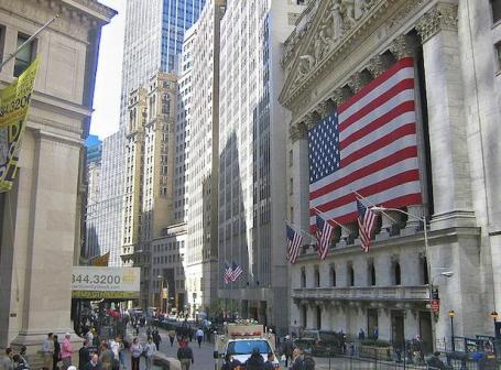
When Emissions Go Up, Stock Goes Down. An intriguing
article over at fastcompany.com confirms my suspicions: follow the money. The energy industry has helped to sow doubt, confusion, fueling much of the misinformation fueling the "denier" movement. It's one thing to have a healthy level of skepticm, but when 97% of all professional climate scientists worldwide say the same thing, and a small, vocal minority continue to cherry-pick data to keep the status quo going, one starts to wonder. The markets abhor uncertainty, and there's plenty of that right now when it comes to EPA regulating greenhouse gases as a form of pollution, how that may play out on Wall Street. Here's an excerpt: "
A new study says markets respond almost immediately when a company reports an event that could affect global climate change, with stock values responding the same day as the disclosure. “It really does appear to be a valuation factor,” says Paul Griffin, professor of management at University of California, Davis. “Greenhouse gas emissions are important to investors in assessing companies.” The study, posted on the Social Science Research Network, a database of social science research, bolsters the arguments of investor groups, environmental advocates, and watchdog organizations that have been seeking greater disclosure of company actions that affect climate change. Although the U.S. Securities and Exchange Commission does not require companies to report greenhouse gas emissions, firms are bound by a rule that mandates disclosure of any information material to stock values. Currently, about half of large U.S. firms report greenhouse gas emissions through the Carbon Disclosure Project, a British organization representing mostly institutional investors...."
Science Suggests There's Much Worse To Come: Science Advisor. In the wake of Category 5 Yasi, which followed historic flooding in Queensland weeks earlier, comes a
story from the Australian:
"The government's climate change adviser Ross Garnaut has warned that the severity of the cyclones and floods which have devastated Queensland in the past month could be the result of climate change and that the science predicts "you ain't seen nothing yet".As Queensland counted the cost of Cyclone Yasi yesterday, Professor Garnaut said climate-change science warned that as global temperatures rose the number of extreme events would intensify. "There's never been a strong assertion in the climate science that you'll get more frequent cyclonic events. There is a strong element in the climate science that you will get more frequent extreme cyclonic events," he said. Professor Garnaut also warned that the latest scientific trends suggested increases in temperatures and sea-level rises were worse than predicted by the Inter- Governmental Panel on Climate Change in 2007. "I think the general tendency is to confirm the IPCC under-estimated the impacts," Professor Garnaut said.
"
Cyclone May Be Tipping Point In Australia Climate Policy Debate. No one storm, winter (or summer) can be blamed on climate change - but the accumulation of extreme events over time may be an importannt signal or symptom of larger trends in the atmosphere. A
story from planetark.org: "
Australia has endured two of its deadliest summers on record, blamed in part on global warming, but record fires, floods and cyclones have not persuaded it to take strong action on climate change. But some experts hope that Wednesday's arrival of giant Cyclone Yasi on the coast of Queensland, already hit by massive floods last month, will help bring more of a sense of urgency to the political debate over climate policy. Environmentalists have despaired that one of the world's highest per-capita carbon polluters will ever embrace the need to cut emissions, given that most politicians and voters have not made a strong connection with disasters and manmade global warming. They say they are baffled why weather-beaten Australians are not pushing for stronger policies to cut carbon emissions from power stations, mines, transport and refineries. "If you want a picture of what a hostile and costly environment looks like, we've had it in spades over the past couple of years," said John Connor, CEO of the Climate Institute think tank."

No comments:
Post a Comment