80.2" snow so far this winter season in the Twin Cities.
0" official snow total on the ground as of Tuesday evening.
7th snowiest winter season as of Tuesday.
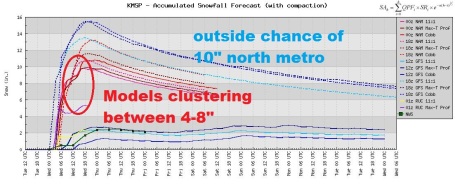
4-8" possible today, less south metro, more north metro.
Boy's Basketbal Tournament in full swing in St. Paul.
La Nina cooling of the Pacific is still moderate in scope, weakening slowly.
 Record Winters
. If we wind up with at least 4" of snow this morning this will be the 5th snowiest winter since 1891. If the final amount from today's storm exceeds 4.7" this would be the 4th snowiest in modern day records. Source: National Weather Service.
 Clash of Seasons.
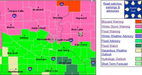
 Flood warnings (bright green) continue to dominate the weather map over southern Minnesota, where recent heavy rains have left streams and rivers swollen and rising. Winter Storm Warnings are now in effect for most of the metro (bright purple shading), except for the southern suburbs, where more precipitation will fall as ice, keeping snowfall amounts lower, closer to 2-4". The latest thinking: a layer of glaze ice, then 4-8" snow on top of that for much of the metro area - making for a fascinating rush hour Wednesday morning. It could have been worse - I don't think we'll see a foot of snow - much of the moisture falling as ice the next few hours, keeping final snowfall totals down a bit. Come to think of it, 4-8" is plenty for the 23rd day of March. The latest watches, warnings and advisories from the NWS are
here.
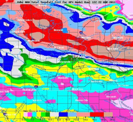
Ice, Then Potential For 4-8" Snow. The latest 00z NAM run prints out 1.4" liquid, but much of that moisture will fall as rain/ice until midnight or 1 am. A changeover to snow is likely during the wee hours of the morning, enough light snow for a final tally in the 4-8" range, but I expect HUGE snowfall variations across the metro area before this thing winds down Wednesday afternoon. 10" is still possible, especially north metro, where more precipitation will fall as snow, rather than ice, over the next few hours.
* How much? Based on the 00z NAM run it still appears ice will give way to a "plowable" snowfall for most of the metro, with a
potential for at least 4-8" in the metro, maybe some 10"+ amounts over the northern suburbs of the Twin Cities..
*
Flood Watch in effect for well over 1" of
additional liquid precipitation (combined rain, sleet and snow).
*
Flood Warnings for many rivers and streams across southern MN. The latest from the NWS is
here.
*
NWS upgrades Winter Weather Advisory to a Winter Storm Warning for most of the MSP
metro area.
* Band of 6-10" possible from Alexandria, St. Cloud and Brainerd Lakes area - possibly extending into parts of the north metro area.
*
Blizzard warnings still posted for Duluth area for as much as a foot of snow by Wednesday PM, but the latest run keeps the heaviest snow bands SOUTH of Duluth, just a few inches.
*
We have never had 3 (one-foot) snowfalls in the metro area in a single winter season. In the event we do pick up a foot (at MSP International) it would be the first time in modern-day records, dating back to 1891.
The odds of 12" of snow at MSP have diminished a little (too much of the main surge of precipitation falling as rain/ice between now and 1 am).
* Most of the snow that does fall will be gone by Friday or Saturday - the sun is too high in the sky for snow to linger on the ground for long.
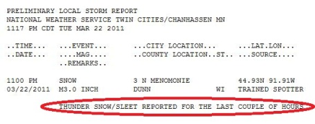 Thunder-Snow
. For the latest snowfall reports from the National Weather Service click
here.
Won't Be Long Until Spring! Right.
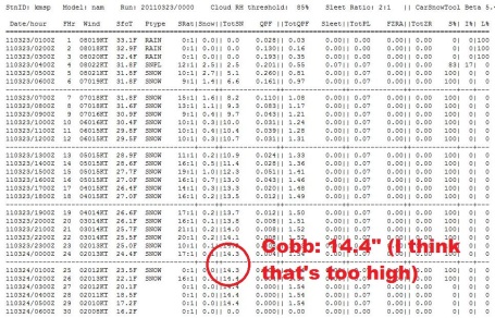
Cobb Method. Using the 00z NAM numbers and the "Cobb Method" for predicting snowfall amounts, a final total of 14" for the metro is predicted. I don't think we'll see nearly that much, because much of the precipitation will fall as an icy mix through the wee hours of the morning (when precipitation will be heaviest). That will make for a nasty layer of glaze ice underneath the snow - but serve to keep final snowfall amounts lower. One caveat: over the north metro I expect more snow than ice, meaning a better chance of winding up with some 10"+ amounts.
Huge Variations. I actually think the 12z run of the NAM has the right idea with (final) snowfall amounts, with the most piling up over the north and northwestern suburbs, where we expect more snow than ice, and some 10"+ amounts are possible. Amounts should drop off as you head south across the metro area, with 4-8" a good average for much of the immediate metro area, but less than 3" over the far south metro, closer to Northfield, Hastings and Montgomery.
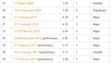
9 "Major Impact" Snowstorms Since March, 2009. Yes, the pace of major winter storms seems to be on the increase, especially across the northeastern USA in recent years, according to an
article at WeatherBell: "
The winter was the third straight winter with memorable storms. 9 of the 44 top impact storms observed since 1956 have occurred since March 2009. 1 in March 2009, 4 in 2009/10 and 4 more in 2010/11. 6 were classified as major, 2 significant and 1 notable. Here is how NOAA describes their NESIS scale. Click on the storm date and see the map of the snowfall amounts. Here is the NOAA NESIS Northeast Snowfall Impact Scale While the Fujita and Saffir-Simpson Scales characterize tornadoes and hurricanes respectively, there is no widely used scale to classify snowstorms. The Northeast Snowfall Impact Scale (NESIS) developed by Paul Kocin and Louis Uccellini of the National Weather Service (Kocin and Uccellini, 2004) characterizes and ranks high-impact Northeast snowstorms. These storms have large areas of 10 inch snowfall accumulations and greater. NESIS has five categories: Extreme, Crippling, Major, Significant, and Notable. The index differs from other meteorological indices in that it uses population information in addition to meteorological measurements. Thus NESIS gives an indication of a storm’s societal impacts. This scale was developed because of the impact Northeast snowstorms can have on the rest of the country in terms of transportation and economic impact."
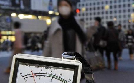
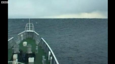
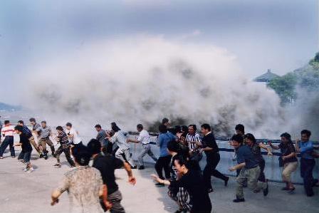
 Tsunami!
 Here is footage of the Japanese tsunami's waves - released by the country's coast guard. Filmed 5 km (3 miles) off the north-eastern coast of Japan, the images show the waves rolling towards the Matsushima coast guard vessel. The captain steers the boat directly into the waves and the ship crests the enormous swell. The BBC has the (amazing) footage
here.
Aftershocks. The New Yorker has a harrowing
account of the earthquake and tsunami that struck Japan on March 11, a first-person account of the horror and aftermath, a worthy read: "
The afternoon of Friday, March 11th, was cool and partly cloudy on the northeast coast of Japan’s main island, a serene stretch once known as the nation’s “back roads.” At 2:46 P.M., as schools were beginning to let out, the ground began to shake. It was violent even by Japan’s standards—the thundering went on for five minutes—and before long Japanese television was warning of a wave charging west across the Pacific Ocean at the speed of a jet. Kicked up from the seabed, the tsunami amplified in size and slowed in speed as it moved into the shallows beside the Japanese coastline, and by the time it touched land it was a wall of water, black and smooth. It was as tall in places as a three-story building, moving at fifty miles per hour. It flicked fishing trawlers over seawalls, crunched them against bridges. It sent fleets of cars and trucks hurtling from parking lots, and turned homes into chips of wood and tile, before heading deeper into Miyagi and Iwate Prefectures across a span of six miles. Rampaging through former farming and fishing villages, and the cosmopolitan city of Sendai, the wave slowed, but remained too fast for most people to outrun on foot."
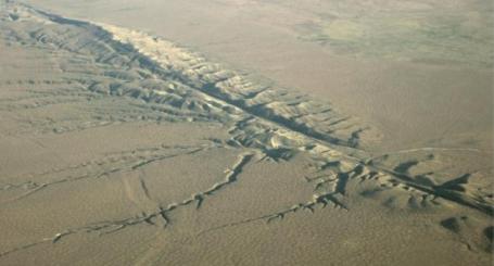
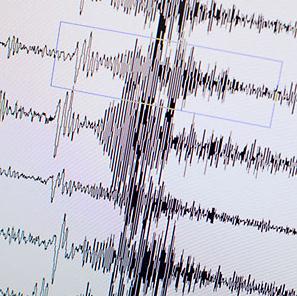
Why We Will Probably Never Be Able To Predict The Next Big Earthquake. We can detect earthquakes and (sometimes) give a few seconds/minutes warning before the shock wave strikes. But there is still no reliable way to predict when/where the faults will slip and the earth will shake, with anything approaching confidence. Here's a good
summary of the factors involved in actually trying to predict a tremor in advance, courtesy of io9.com: "
In the wake of the massive 9.0-magnitude earthquake that has devastated Japan, an obvious question arises...why didn't we see it coming? The fact is that earthquake prediction has long baffled scientists, and the current consensus is that it's actually impossible. There are very few areas of science where experts are actually willing to make definitive statements that something is impossible. And yet that's pretty much exactly where the field of earthquake prediction stands, at least ever since a 1996 paper in the journal Science in which four seismology experts published a paper simply entitled, "Earthquakes Cannot Be Predicted." That's a remarkably absolute statement, and it's worth understanding just why seismologists took such a strong stance."
What Happens When A Mega-Earthquake Strikes The USA? Popular Mechanics
ponders the horrific implications of a 9.0 earthquake in the United States. The thing is - it's happened in the past:
"Could a Sendai-size earthquake happen here in the U.S.? Experts say it's not a matter of if, but of when. The areas most at risk are not, as you might expect, California's cities. While they frequently suffer damaging quakes, their seismic woes are due to a relatively shallow phenomenon called a strike-slip fault, caused by two tectonic plates grinding against each other. The Sendai event, which struck Japan in March with a magnitude of 9.0, resulted from a far more dangerous "megathrust," or subduction fault, in which one plate slides underneath another. The contiguous U.S. hasn't experienced such an unleashing of geological violence since Jan. 26, 1700, when a subduction fault off the coast of the Pacific Northwest ruptured with a magnitude of 9.0, sending a 30-foot wall of water roaring across the ocean. Twelve hours later, it smashed buildings and killed people in coastal Japan, 4500 miles away. In 1700, the Pacific Northwest was sparsely inhabited. Today, the combined population of Portland and Seattle is more than 1.1 million people, and based on geological evidence, there's a 10 to 15 percent chance another quake of that magnitude will strike those cities in the next 50 years. Other cities in quake-prone regions are also vulnerable, including such unlikely places as Memphis, Tenn., Charleston, S.C., and New York City. And California's San Andreas Fault, while not of the megathrust type, remains formidable. Running close to most of the state's big population centers, it has a history of producing a large quake roughly every 150 years. (The last one was 154 years ago.) In all, 75 million Americans live in areas where quakes could cause substantial damage."
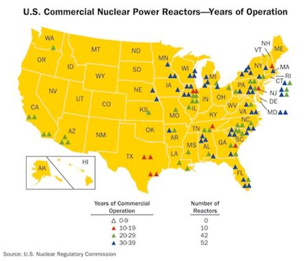
Nuclear Reactors In Earthquake Zones In The USA. Treehugger.com
examines the reactors near fault lines in the USA: "
As we watch with baited breath to see if Japan can dodge a nuclear catastrophe, nuclear-powered nations themselves have succumbed to heavy scrutiny over both policy and safety. The United States leads the pack in operational nuclear power reactors with 104 total, and 32 additional reactors used in research. France comes in second with 58 reactors, Japan has 54 and Russia, 32 reactors. South Korea, India, UK, Canada, Germany and the Ukraine round out the remaining top ten, each with less than 20 reactors. While it might seem grossly opportunistic to discuss this while Japan is still reeling from the quake and struggling with their nuclear plants, it is well worth looking within our own borders to see if we are prepared for, or can avert, a similar disaster. California itself has two coastal nuclear plants with one less than a half mile from a fault line. Let's take a closer look at the US plants and where they fall along quake zones.In light of what happened in Japan, Germany has shut down all nuclear power plants that began operation before 1980; seven total. They will remain off until at least June. But France and the U.S. have no immediate plans to draw back from nuclear (or to even consider it), an odd stance for the U.S. as 2010 saw its share of nuclear safety near-misses."
. The U.K. Telegraph has an
article about a new generation of (allegedly safer) nuclear power plants fueled with thorium: "
This passed unnoticed –except by a small of band of thorium enthusiasts – but it may mark the passage of strategic leadership in energy policy from an inert and status-quo West to a rising technological power willing to break the mould. If China’s dash for thorium power succeeds, it will vastly alter the global energy landscape and may avert a calamitous conflict over resources as Asia’s industrial revolutions clash head-on with the West’s entrenched consumption. China’s Academy of Sciences said it had chosen a “thorium-based molten salt reactor system”. The liquid fuel idea was pioneered by US physicists at Oak Ridge National Lab in the 1960s, but the US has long since dropped the ball. Further evidence of Barack `Obama’s “Sputnik moment”, you could say. Chinese scientists claim that hazardous waste will be a thousand times less than with uranium. The system is inherently less prone to disaster. “The reactor has an amazing safety feature,” said Kirk Sorensen, a former NASA engineer at Teledyne Brown and a thorium expert."
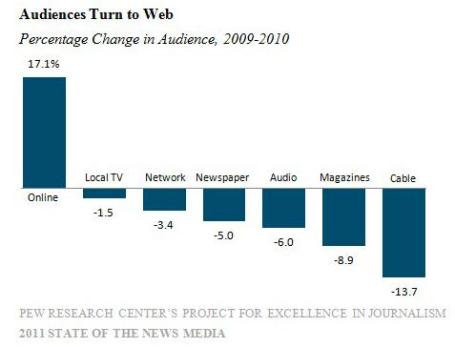
Pew: Local News Undergoes Radical Change. It's no secret that we're all finding new ways to find news, grazing on tweets, FB posts, web links and video snippets throughout the day. Broadcast Engineering has a
summary of the state of the media (and how - increasingly - we're getting our news): "
The Internet will soon become the nation’s number one source for local news. Growing rapidly in influence, the Internet has finally overtaken newspapers and is just behind TV in a transitional sweep that is forever changing the landscape of local news and the outlets that matter to a younger generation of news consumers. The problem for all traditional news organizations, including broadcasters, is that by far the largest share of that online ad revenue goes to non-news sources, particularly to news aggregators. The findings are in a “State of the News Media” report produced by the Pew Research Center’s Internet and American Life Project in association with the Knight Foundation. Technological advances have added a new layer of complexity, and a new set of players, to connecting local news content to consumers and advertisers. Today, 47 percent of news consumers get their information on a mobile device."
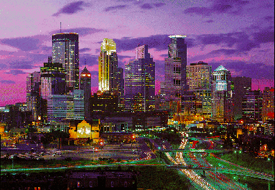
Twitter Towns, USA. Yes, we have much to be proud of in Minnesota, including Minneapolis's increasingly wired (and social) reputation. Here's an
article in Men's Health proving our twittering prowess. I feel healthier just reading that magazine, by the way: "
When we first decided to crown one town America's Most Socially Networked City, our money was on Palo Alto. As home to the headquarters of Facebook, Palo Alto might as well be called Zuckerburgh. But the title instead goes to Washington D.C., a city where staying connected can get out the vote, and virtual handshakes help shape our nation. We started by calculating the number of Facebook and LinkedIn users per capita, followed by overall Twitter usage (NetProspex). Then we looked at traffic generated by the major social networks, including Myspace, Friendster, Reddit, and Digg (analyzed by ad network Chitika). Finally, after factoring in the percentage of households that check out chat rooms and blogs (SimplyMap), we had the results you see below. Go ahead, tell a friend.
Most socially networked
1 Washington, DC A+
2 Atlanta, GA A+
3 Denver, CO A+
4 Minneapolis, MN A+
 Tuesday Soaking
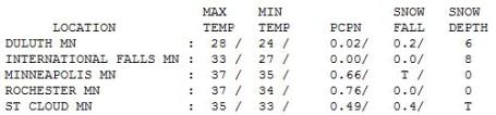
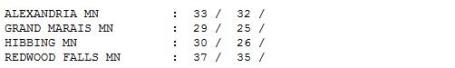
. The NWS reported .66" of rain on Tuesday (including some thunder and lightning). Three quarters of an inch of rain fell on Rochester. Highs held in the 30s - had the mercury been just 3-5 degrees colder we would have picked up an
additional 5-8" snow yesterday. Yes, it could have been worse.
 Paul's Conservation Minnesota Outlook for the Twin Cities and all of Minnesota:
TODAY: Winter Storm Warnings. Heavy wet snow, potential for 4-8", maybe 10"+ over parts of the north metro. Slow commutes. Winds: NE 10-20. High: 32
WEDNESDAY NIGHT: Light snow tapers to flurries - may wet roads become icy in spots. Little additional accumulation. Low: 16
THURSDAY: Peeks of sun, snow begins to melt. High: near 30
FRIDAY: Chilly, slushy coating - 1" of light snow? Low: 21. High: 34
SATURDAY: Flurries linger, where's spring? Low: 22. High: 33
SUNDAY: Fewer flakes, sick of heavy jackets. Low: 19. High: 35
MONDAY: Mostly cloudy, not as harsh. Low: 21. High: 39
TUESDAY: Fading sun, hints of spring return. Low: 28. High: 45
Snowblind
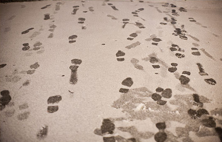
"To be interested in the changing seasons is a happier state of mind than to be hopelessly in love with spring" wrote George Santayana (from somewhere in Florida). Yes, March is the acid test for winter-weary Minnesotans. Changing seasons? 50s Saturday, heavy rain (and lightning) yesterday, sleet overnight, now heavy, wet, tree-limb-crushing snow, followed by a risk of flooding.
The (fickle) computer models now bring the heaviest snow bands into the MSP metro; an outside chance of a FOOT of snow, especially north metro. Good grief. Three one-foot snowfalls in one winter? As far as I know that has never happened before in a single winter season in the Twin Cities. "May you live in interesting times", right? This should be "plowable", a good chance of 4-8" for much of the metro area, with an outside chance of 10"+. Ugh.
Not sure who/what to blame: La Nina or the Boys Basketball Tournament in St. Paul. The "beauty" of a late March snow? Most of it will melt in a few days. Deep breaths; this too shall pass. Chilly 30s linger into the weekend - 40s return by Tuesday.
All this additional rain and snow will make a bad flood season much worse. Stay alert; updates on the blog.
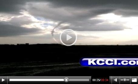
Iowa Tornadoes.
Here is video of the tornado that touched down near Creston, Iowa, Tuesday evening, courtesy of KCCI-TV.
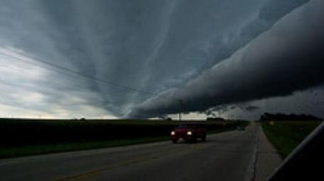
Tornado 101: The Basics. Severe storm season is fast approaching - on Tuesday there were tornadoes on the ground as close to us as Iowa (suburbs of Des Moines).
Here's a good recap of tornado basics from the Mother Nature Network: "
The recent natural disaster in Japan reminds us all of just how staggering a visit from Mother Nature can be, even if we are prepared for it. In the Midwest, we witness a wide range of temperature problems and are sometimes held captive by extreme colds or heat waves that can be life threatening. Blizzards humble us and can shut down entire states with their ferocity. Flooding is always a concern, with the area on alert again this spring to see if higher temperatures will unleash runoff into the major rivers that cannot be contained, especially after the record breaking snows this winter have already raised the water levels. But while these phenomena cause the most deaths and destruction, Americans are fascinated with the ravaging storm systems that appear in spring and bring on the T. rex of land storms: the mighty tornado. Tornadoes occur when cold and warm air collide, most often during seasonal changes in the spring and fall, although they can find us at anytime of the year. Illinois witnessed a rare winter tornado on Nov. 22, 2010, as temperatures that week fluctuated between the 40s and 70s. They spawn from supercell thunderstorms and extend from clouds as the familiar, funnel-shaped menace with winds that can reach 300 mph and decimate everything in their path."
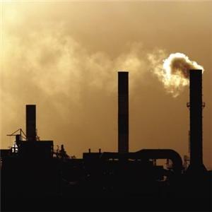
The Content Of Carbon Dioxide In The Atmosphere Is Accelerating, Super-Exponentially. Here's an excerpt from a troubling
article at Climate Progress: "Recent climate science is unequivocal that
human civilization is on the precipice. Climate science also finds that we are pouring carbon dioxide pollution into the atmosphere at an unsustainable rate. A 2008
Nature Geoscience study found that
humans were boosting CO2 levels 14,000 times faster than nature, overwhelming slow negative feedbacks. That study found, “the mean long-term trend of atmospheric CO2 levels is no more than 22 p.p.m.v. over the past 610,000 years.” Humans have run up CO2 levels 100 ppm over the last two centuries! The author of that study noted, “Right now we have put the system entirely out of equilibrium” It turns out that a purely mathematical analysis, “
Evidence for super-exponentially accelerating atmospheric carbon dioxide growth,” comes to a similar conclusion. The paper itself is mostly mathematically and essentially agnostic on climate science. But the conclusions are as stark as any in the climate literature:
Overall, the evidence presented here does not augur well for the future.
- Notwithstanding a lot of discussions, international meetings, prevalence in the media, atmospheric CO2 content growth continues unabated with a clear faster-than-exponential behavior. On the face of this evidence using data until 2009, stabilizing atmospheric carbon dioxide emissions at levels reached in 1990 for instance seems very ambitious, if not utterly unrealistic. We are not pessimistic. We think that only evidence-based decision making can lead to progress. The present evidence gives some measure of the enormous challenges to control our CO2 emissions to acceptable levels.
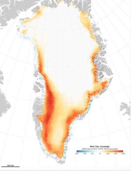
Record Melting of Greenland During 2010. Map courtesy of NASA's Earth Observatory. Here's an
article that caught my eye: "
The Greenland ice cap is dissolving faster than ever. Global warming is continuing at record levels, and the arctic regions are indeed melting at an extremely fast pace. The reason for the exceptional melt off was the fact that the unusual warmth in the spring of 2010 got the melt season off to a strong start. The early melting set the tone for the rest of the season, leading to more melting all the way into mid-September. In fact, places colored deep red on the map below, the melting season has lasted 60 days longer than the average of the last 30 years. According to NASA, “Melting ice in Greenland freshens the seas near the Arctic and contributes to rising sea levels around the world. It is unclear just how much melting ice from Greenland will push sea levels up, largely because the melting is occurring much more quickly than scientists predicted. Current estimates call for an increase of up to 0.6 meters by 2100.” NASA has created this remarkable infographic that shows just how alarmingly fast Greenland is melting away."
Google Takes On Climate Skeptics With New Technology Effort. Here's an
article from solveclimatenews.com: Google has brought together a team of 21 climate researchers to improve the way the science of global warming is communicated using new media. "
Kelly Levin, a senior research associate at the World Resources Institute, a conservation group, said she hoped the Google program could tackle that challenge by engaging wider audiences in the scientific discussion. "Given the pace and scale of human-induced climate change, it is of great importance that climate change science, and the urgency of addressing the climate change problem, is communicated effectively to the public and decision makers," she said. She added: "Involving the public more directly in the scientific process could increase the acceptance of ideas and help scientific advancements inform governmental policies."
A More Accessible Approach
Throughout the year, the Google fellows will sharpen their new media skills, learn data-sharing technologies and improve communication strategies to lend a more accessible approach to climate science."

No comments:
Post a Comment