1.11" rain predicted for the metro area by Wednesday afternoon (NAM model).
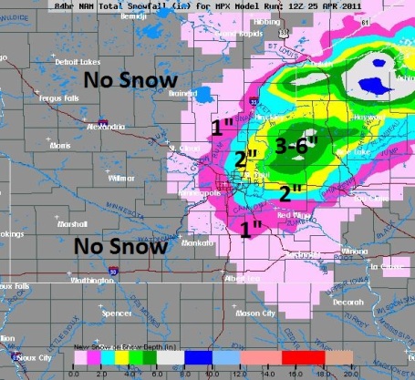
Slush possible Wednesday morning, especially north/east of the Twin Cities.
70 F. possible Friday afternoon.
T-Storms possible Friday night.
33 tornadoes reported nationwide Monday, 266 severe storm reports (SPC). By the end of the week as many as 200 tornadoes are expected from Texas into the Carolinas.

A Stormy Week. The latest numbers are in, and all I can say - I hope you enjoyed 60-degree sunshine Easter Sunday & Monday. A long-fuse storm is brewing for Tuesday - Thursday, mostly rain (some 1-2" amounts possible), possibly mixing with a little slushy snow by Wednesday morning, especially north/east of the MSP metro area. I want to stress that MOST of the precipitation will fall as a cold rain, and even if it does snow Wednesday roads should stay wet. We don't dry out until late Thursday and Friday before the next storm arrives with more showery rains Friday night into Saturday. A stormy week, yes, but at least we're on the cold, stable, northern side of the storm track (translation: no tornadoes to worry about). Yes, it could be worse: another major tornado outbreak is predicted from Mississippi River Valley to the east coast this week. Is our on-again, off-again spring annoying? You bet, but slush won't take your roof off.
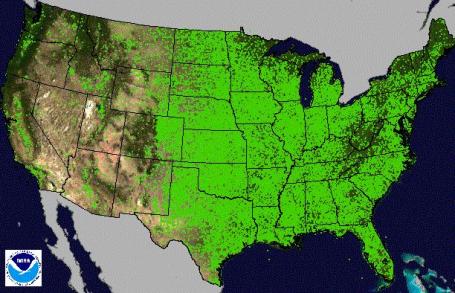
Tornado Nation. All those green lines and dots on the map east of the Rockies? Tornado strikes from 1950 to 2010, according to SPC, the Storm Prediction Center. More details from AOL News: "Tornado touchdowns have historically been numerous in the Midwest and the Carolinas, as well as in the Deep South, which is sometimes referred to as "Dixie Alley" because of its elevated tornado threat. The southern heat and humidity are potential fuel for tornadoes, but the contrasting cooler, dry air is not as abundant as it is in the Plains. The Atlantic Seaboard, including the major cities from New York to Washington, has been a relatively active region since 1950 compared with the Appalachian region just to the west.This distribution of tornadoes often feeds into the myth that mountains protect communities from tornadoes. In fact, the more rugged terrain of the mountainous region does not disrupt tornado tracks or prevent formation of tornadoes; however, the slightly cooler and drier climate leads to conditions less conducive to formation. In other words, the relative lack of tornado touchdowns in mountainous regions is because of the weather, not the terrain."
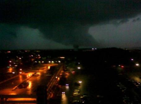
Wedge Tornado. News is sketchy - it's believed this is the tornado that hit Little Rock Air Force Base late Monday. Tornadoes that hit at night cause a disproportionate number of deaths and injuries - they're hard to track, people are asleep. If you don't have a NOAA Weather Radio there's no way to get the word unless you're awake (and monitoring local media).

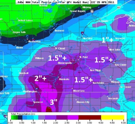
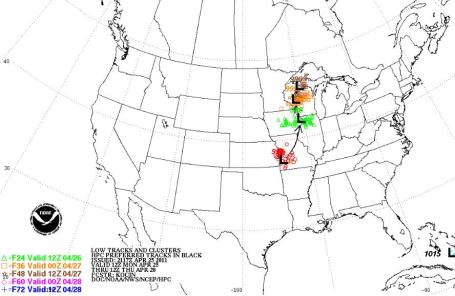
Storm Track. A powerful storm over southwestern Missouri reaches Wisconsin by late tomorrow, pulling moisture from the Gulf of Mexico due north, right up the Mississippi River Valley. The result may be the most significant rain event of spring so far for much of Minnesota.
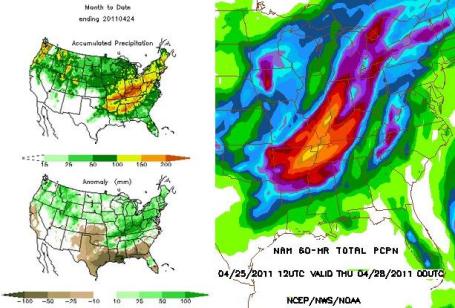
Potential For Record Floods. Stu Ostro from the Weather Channel reports on the potential for more flooding across the nation's midsection. Many towns in Indiana and Kentucky has already been drenched with nearly a foot of rain, some communities picking up a month's worth of rain over the weekend. Ostro writes "This visualizes a very serious situation: additional excessive rainfall expected on top of what has already fallen recently. There are uncertainties in the small-scale details of the model forecast, but the overall setup is straightforward and certain: an extreme threat of flooding and flash flooding, almost exactly a year after when it happened in a similar area in 2010."
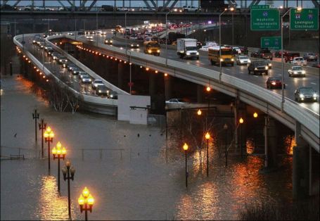
Kentucky Governor Declares State Of Emergency. The ground is already saturated, waterlogged from as much as 10-15" of rain in recent weeks, and a stalled front promises to dump another 7-10" by Thursday. The full story from WLKY-TV: "Kentuckians are bracing for what some officials say could be historic flooding, leaving low-lying areas and readying sandbags as streams rush, rivers rise, and severe storms continue. Gov. Steve Beshear has declared a state of emergency in Kentucky.Heavy rains and multiple rounds of severe weather throughKentucky, Southwest Missouri, Southern Illinois and Southern Indiana over the weekend left the ground saturated and the rivers running above flood stage.The weather pattern is expected to continue for the next several days.Beshear said Kentucky will likely request a federal declaration of emergency.The Ohio and Mississippi rivers are forecasted to have major flooding with the possibility of historic flooding along the rivers from Kentucky-Tennessee line.“Today I have issued this declaration in order to make sure our citizens and local officials have all the help they need to prepare and respond to these storms,” said Beshear. “This declaration opens up the pipelines and the purse strings to enable us to get resources to where they are needed, as quickly as possible. In addition, all of state government has been mobilized to assist Kentuckians in need.”
United (Severe) States of America. Thanks to meteorologist Todd Nelson for sharing these storm facts:
Total Number of Storm Reports (Hail, High Winds, Tornadoes): 6298
Tornado Reports: 574 (many are multiple reports)
______________________________________________
**There have only been 8 days with no tornadoes reported this month**
**There has only been 1 day this month with no storm reports** (April 6th)
**There Were 2 Days This Month With Over 1000 Storm Reports** (April 4th @ 1476 (68 Tornado Reports) & April 19th @ 1004 (75 Tornado Reports))
**There Were 2 Days This Month With Over 100 Tornado Reports** (April 15th @ 146 Tornado Reports & April 16th @ 139 Tornado Reports)
**There Have Been 39 Tornado Deaths This Year** (Most Since 2008: February 2008 There Were 59 Deaths & May 2008 There Were 44 Deaths)
**There Have Been 12 Killer Tornadoes This Year**
______________________________________________
(Preliminary) April 2011 Actual Tornadoes: 292 (Could Be the Most Tornadoes in the Month of April Ever Recorded!)
(Previous) April Tornado Record: 267 in 1974 (Same year as the "Super Outbreak")
(All-Time) Tornado Record for a Single Month: 543 in May 2003
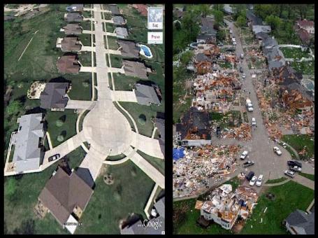
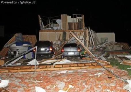
St. Louis Tornado, Before & After The Storm. No other photo better illustrates the destructive (and fickle) nature of tornadoes better than this image. Details: "Before and after damage photo of Beaverton Drive in Bridgeton, Missouri, after the April 22, 2011 tornado. This damage was rated EF3. Image credit: National Weather Service office in St. Louis and Google." Meteorologist Jeff Masters takes a look back at the St. Louis outbreak, another (major) tornado outbreak looming this week, and a look back at March, 2011 in his Wunderblog.
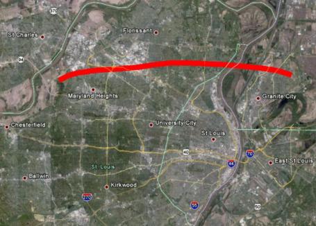
The "Good Friday Miracle". EF-4 Tornado In St. Louis. No Fatalities Or Serious Injuries. More on the most violent tornado to hit the St. Louis area in 44 years from the local office of the National Weather Service: "A tornadic supercell crossed the Greater St. Louis Metropolitan Area with many reports of large hail and damage from New Melle in St. Charles County to Granite City in Madison County, Illinois. Some of the most intense damage occurred in St. Louis County across Maryland Heights, Bridgeton, St. Ann, Edmundson, Lambert St. Louis International Airport, Berkeley, and Ferguson and in Madison County near Granite City. Several people were injured by flying debris and glass at the main terminal of the airport, but remarkably there were no fatalities. Two tornadoes were confirmed so far from this event. The first was near New Melle and was rated EF1, the other was a long-track tornado that was rated EF4 and affected St. Louis and Madison Counties as well as the extreme northern tip of St. Louis City. The EF4 tornado is the strongest tornado that has occurred in St. Louis County for 44 years. You have to go back to January 24th 1967 to find a tornado that was as strong. In fact, the tornado paths are very similar.

Tornado Damage. Check out these incredible photos of the damage done by last Friday's EF-4 tornado. A Facebook account may be required (but who doesn't have a FB account these days?)

Exhibit A. Check out the tornado damage in Bridgeton, Missouri, courtesy of Picasa. Winds may have approached 200 mph in the EF-4 tornado that roared through this community Friday afternoon. It's a miracle that no one was killed or even seriously injured in this major tornado strike - a testament to National Weather Service warnings (at least 20 minutes lead time), local TV and radio, and storm spotters who were able to confirm that severe rotation on Doppler was, in fact, producing a major, long-lived tornado.
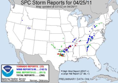
Monday Storm Reports. SPC reports 33 tornadoes yesterday from Texas to Tennessee. Details here.
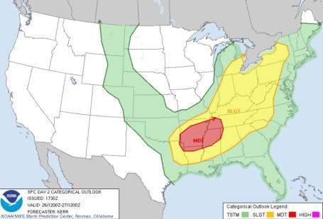
Today's Severe Outlook. According to SPC there is a moderate threat of tornadoes over the Lower Mississippi Valley, from roughly Shreveport to Little Rock to Memphis.
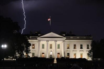
A Sign From Above? I thought this was an interesting photo; a cloud to ground lightning strike precariously close to the White House on Easter Sunday. More details from obamafoodorama.com: "Nothing to do with White House food initiatives, but I thought that fellow armchair storm enthusiasts would appreciate these photos. Tonight was actually a warm, still Easter evening in Washington--until all of a sudden, it wasn't. I shot these at about 8:30 PM. A storm rapidly materialized in the Southern sky, and swept from the National Mall toward the White House. Instantly, there seemed to be lightning bolts dropping out of the heavens all around 1600 Pennsylvania Avenue--and the wind kicked up dramatically."

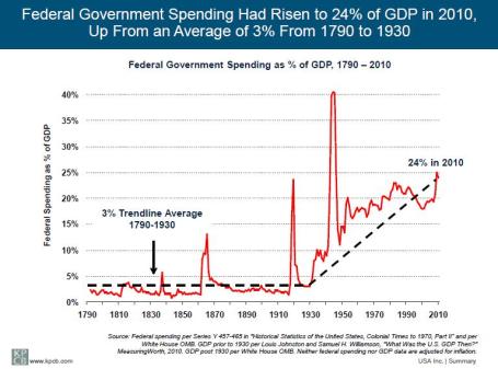
USA Inc. If the USA were a traditional company, not only would we be bankrupt, but we'd be in receivership; creditors would be picking over the pieces of what's left. Financial analyst Mary Meeker and Morgan Stanley have prepared an exhaustive report about America's finances, how we got here, and (stark) options for the future. It's a long read, but potentially one of the most important documents you'll come across this year: "This report looks at the federal government as if it were a business, with the goal of informing the debate about our nation’s financial situation and outlook. In it, we examine USA Inc.’s income statement and balance sheet. We aim to interpret the underlying data and facts and illustrate patterns and trends in easy-to-understand ways. We analyze the drivers of federal revenue and the history of expense growth, and we examine basic scenarios for how America might move toward positive cash flow."


Filtering The Social Web To Present News Items. Social media has unleashed a torrent of news (and noise). Filtering out the truly newsworthy nuggets is difficult, but a San Franciscon start-up is attempting the impossible, according to a recent story in the New York Times: "SAN FRANCISCO — News events as varied as the commercial jet landing in the Hudson River and the uprisings in Egypt have demonstrated that people armed with cellphones — not professional reporters — are often the first source of breaking news, uploading Twitter posts, photos and video to the Web. But the result can leave people drowning in too much information. "A Web start-up named Storify, which opens to the public Monday, aims to help journalists and others collect and filter all this information. Using the Storify Web site, people can find and piece together publicly available content from Twitter, Flickr, Facebook, YouTube and other sites. They can also add text and embed the resulting collages of content on their own sites. During a private test period, reporters from The Washington Post, NPR, PBS and other outlets used the service. Storify, based in San Francisco, is one of several Web start-ups — including Storyful, Tumblr and Color — that are developing ways to help journalists and others sift through the explosion of online content and publish the most relevant information. Investors are also betting there is a market for filtering the social Web for high-quality posts. Khosla Ventures has invested $2 million in Storify."

Scuffle Over On-Demand Movies Portends Battles To Come. Enjoying Netflix and on-demand streaming to that big HDTV set in the family room? The success of Netflix has Hollywood's movie studios jealous, and concerned about their business models in an age of instant-gratification. They're trying to avoid the fate of music labels, as described in this N.Y. Times article: "LOS ANGELES — Hollywood is picking sides for its first all-out brawl since its writers’ labor feud in 2007. And oddly, Christopher J. Dodd, once a powerful senator from Connecticut and now the film studios’ chief spokesman, has mostly been out of the fray. The blow-up is between studios and theater owners over a plan to slip some movies into homes through on-demand video shortly after they arrive in theaters. For Mr. Dodd, the new chairman of the Motion Picture Association of America, it is the first industry crisis since he started in late March. “I’m the new kid on the block,” Mr. Dodd said in an interview by phone on Friday, acknowledging that both his relative inexperience and the need to stay out of business decisions made by individual studios had kept him largely out of the battle. “Each company has to make up its own mind.” Studios, exhibitors and filmmakers are arguing about the future of the business, and whether people in coming years will be more likely to watch movies in theaters or in increasingly sophisticated home setups mimicking the quality, immediacy and, perhaps, cost, of today’s theatrical experience."

Advertising-Dependent TV Under Fire. An interesting article from Business Insider. Will broadcast television still be the dominant form of advertising in 5 years? Will Internet-enabled TV sets with the ability to personalize advertising make a material difference, or are (most) targeted advertising budgets migrating to the web and mobile devices? "Advertising-dependent television may have dodged one bullet this year only to be crippled later by an intensifying barrage of economic and tech threats that will alter its fragile status quo. The Internet Advertising Bureau recently confirmed that $26.4 billion in Internet media spending in 2010 handily beat $22.8 billion in newspapers. It's just a matter of time before it matches TV's dominant $28.6 billion in revenues last year, $16 billion of which is from broadcast and the remainder from cable. After all, the online ad market grew 15% during the heart of the recession from 2009 to 2010. Why wouldn't it pick up more steam with increased consumer and enterprise digital adoption? Nascent mobile advertising has nowhere to go but up. A closer look at the IAB's new report shows that Internet ad revenues are driven by retail, telecom, financial services and autos, which have been TV advertising mainstays. They are clearly attracted to the more justifiable performance metrics and measurable ROI. Not too many years from now, many marketers will be wondering how they ever were suckered into slapping their money into the TV networks' critical mass in hopes that something sticks. Like newspapers, many local TV stations are out-maneuvered by savvy, inexpensive online, social and hyper-local options -- from Groupon to Google to Facebook. Their costly physical plant and legacy operations can't compete. For some TV station owners -- perhaps eventually including Disney's ABC and Comcast's NBC -- exiting the business may be the only answer amid what is sure to be rampant streamlining and market consolidation."
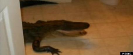
Definition Of A Bad Day: Finding A 7-Foot Alligator In Your Bathroom. Talk about the definition of a heart attack - here's the story from Huffington Post: "PALMETTO, Fla. (AP) -- A Tampa-area woman found an unwelcome weekend guest in her bathroom – a 7-foot alligator. Alexis Dunbar says she screamed and the alligator hissed when she found it inside the bathroom of her home Saturday afternoon. Her boyfriend propped a small table by the bathroom to keep the gator inside until an officer from the Florida Fish and Wildlife Conservation Commission showed up to take him away. Dunbar believes the alligator used a doggie door on the back porch to get inside the house. Dunbar lives in Palmetto, which is south of St. Petersburg."
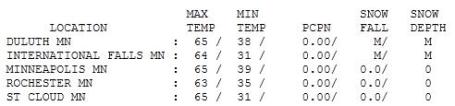

Spring The Way It Was Meant To Be. What a Monday. Highs were in the 60s statewide, with the exception of poor Grand Marais, stuck at 47 with a raw breeze off Lake Superior. Highs ranged from 61 at Redwood Falls to 65 in St. Cloud and the Twin Cities, to a balmy 68 in Hibbing.
Paul's Conservation Minnesota Outlook for the Twin Cities and all of Minnesota:
TODAY: A cold rain likely. Raw breeze. Winds: NE 15-25. High: 47
TUESDAY NIGHT: More rain, possibly heavy at times. Low: 36
WEDNESDAY: Mix of rain/snow early. Coating of slush possible early (especially western Wisconsin). Rain showers linger. High: 46
THURSDAY: Damp start, clouds giving way to some PM sun. Low: 38. High: 57
FRIDAY: Spring fever returns with lukewarm sunshine much of the day! Nighttime T-storms? Low: 42. High: near 70
SATURDAY: Damp start, breezy & cooler with some sun. Low: 48. High: 62
SUNDAY: Mostly cloudy windy and cool, few sprinkles. Low: 40. High: 51
MONDAY: Intervals of sun, a little better. Low: 38. High: 56

Watering Optional
Look at the bright side: you will NOT be distracted by chirping robins, outdoor lunches or a beckoning sky anytime soon. Just think how green/lush your lawn will look by Thursday. Latest models are hinting at 1-2" of rain by Thursday morning. Yes, most of this "precipitation" will fall as a cold rain, the best chance of 2" near the Iowa border. A cooling trend by Wednesday may spark a rain-snow mix; a coating of slush can't be ruled out Wednesday morning, maybe a few inches of snow near Eau Claire & Hayward, Wisconsin. Cue the primal scream.
At least we're on the cool, stable, tornado-free side of the storm track. Another major outbreak of tornadoes is likely from St. Louis to Nashville and Atlanta. April is on track to approach the all-time record for tornadoes in a single month: 543, set in May, 2003. A swirling, La Nina-turbocharged jet stream howling above America is responsible for a flurry of tornadoes and extreme flooding over the Ohio Valley (where a major earthquake drill is scheduled for Thursday morning).
I'm feeling better about the rain. Springy 60s return Friday, followed by T-storms Friday night and a cool weekend breeze. Still too early to retire the jackets.
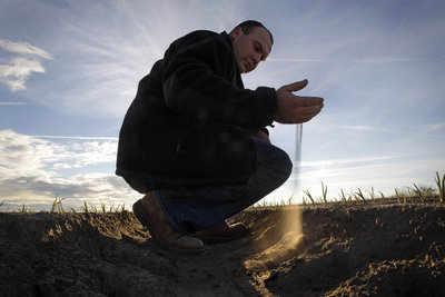
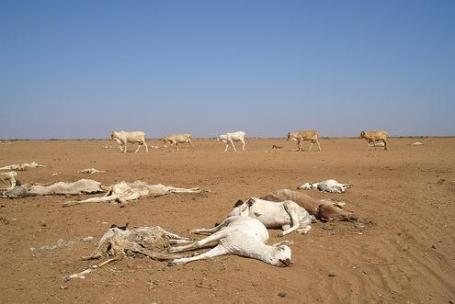
Experts: Drought Could Continue In Southern U.S. The heat is building, especially over Texas, and there is mounting concern about drought conditions expanding through the Deep South. More from chron.com (serving Texas): "FORT WORTH, Texas — The extreme drought that has gripped parts of nine states — most of them in the South — is expected to drag on for several months or intensify, posing a risk for more wildfires, agriculture problems and water restrictions, national weather experts said Monday. Portions of Texas and a small part of eastern Louisiana are the only parts of the nation that rank in the National Weather Service's worst drought condition category, said Victor Murphy, the climate service program manager for the National Weather Service's southern region, based in Fort Worth. The "exceptional" drought level happens once every 50 to 100 years, he said. Much of the rest of Texas and Louisiana are in extreme drought conditions — the worst in 20 to 50 years — as are parts of Arizona, New Mexico, Oklahoma, Arkansas and Florida and tiny portions of Colorado and Kansas. Other areas of those states are experiencing severe and moderate drought conditions, along with parts of Mississippi, Alabama, Georgia and South Carolina."
Probing The Impact Of Climate Change. Redorbit.com has the story: "What do polar bears, hummingbirds, clams, bowhead whales and invasive plant species have to do with Earth science spacecraft orbiting overhead 24/7? Soon observations from NASA's Earth-observing satellites of our planet's climate will be brought to bear on understanding how different species and ecosystems respond to climate changes and developing tools to better manage wildlife and natural resources. NASA has joined with the U.S. Geological Survey, National Park Service, U.S. Fish and Wildlife Service and Smithsonian Institution to initiate new research and applications efforts that will bring the global view of climate from space down to Earth to benefit wildlife and key ecosystems. This is the first time NASA has targeted research investigating the intersection of climate and biological studies. The projects are sponsored by the Earth Science Division in NASA's Science Mission Directorate. The wildlife species to be studied include polar bears in Greenland, bowhead whales in the Arctic Ocean, and migratory birds and waterfowl in the United States. Other studies will focus on species of commercial interest such as clams, oysters and other bivalves in U.S. coastal waters, and Atlantic bluefin tuna in the Gulf of Mexico. To learn more about climatic effects on plants, researchers will focus on the loss of cordgrass marshes in coastal wetlands of the southeastern states. They also will examine the stresses to native tree species, many of commercial value, across the western states and Canada."
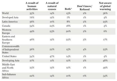
Gallup Surveys The World On Climate Change. Planetsave.com has some rather unsettling statistics: "Gallup surveys conducted in 111 countries throughout 2010 have yielded interesting results that, once again, show America to be behind the times on accepting fault for the current climate change. The figures follow trends in America that see a continuing downhill climb of those who believe climate change is happening, a threat, or their fault. But this downhill climb is not restricted to the US, rather, it is most obvious there, a result probably of the linkage the issue has to which political leaning you enjoy. When asked whether rising temperatures are a result of human activities or natural causes, the figures are somewhat astounding, as can be seen in the chart below."
Top 10 Greenest States. How did Minnesota not make this list? Granted, it's somewhat subjective, but this can't be right. Here are the details from Huffington Post: "Earth Day is the perfect time to celebrate the positive steps that some states are taking to preserve the environment. This year, the theme for Earth Day is "A Billion Acts of Green." The idea highlights the fact that many small acts can make a significant difference to the environment. Last year, 24/7 Wall St. analyzed the environmental issues facing the each state. In observance of Earth Day, the rankings have been updated to reflect the most recent data. 24/7 Wall St. examined energy consumption, pollution problems and state energy policies. The most recent information, issued in 2009 and 2010, was used for all states. Thousands of data points were collected to determine the most and least “green” states. Below are the ten greenest states in the 24/7 Wall St. ranking, based on environmental problems and how effectively these problems are addressed."
Paul,
ReplyDeleteThat link to the article regarding the USA as a business is EXACTLY what's WRONG with the political debate in our country right now.
A sovereign nation is NOT a business. There is no profit motive, nor should there be. The bottom line of a business is to make money. The bottom line of a nation is to serve its citizens by providing essential services that collectively benefit everyone. That is a huge difference, and the sooner we acknowledge that, the better off we'll be.