41 F. high in the Twin Cities on Saturday (average high is 58 F.0
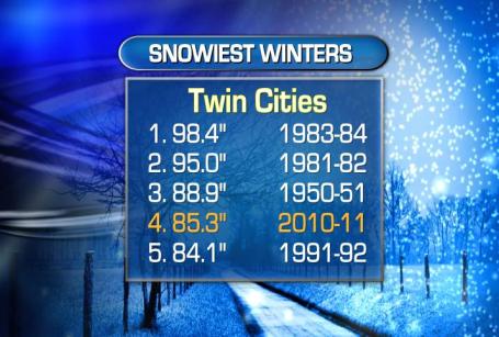
85.3" snow so far this winter at MSP.
4th snowiest winter on record in the Twin Cities metro area.
3.7" required for this to be the 3rd snowiest winter on record.
Snowfall Reports from Friday night's storm:
4.5" Farmington (Dakota County)
4.5" River Falls, Wisconsin
3.5" Londsdale (Rice County)
3.3" Hastings
2.9" Hamburg (Carver County)
2.4" Inver Grove Heights
1" Downtown St. Paul
What Month Is This Again? Weather spotter Rich Koivisto captured this photo from his yard Saturday morning. Officially 3.2" fell on downtown Duluth, but higher amounts were observed from the Iron Range to the North Shore of Lake Superior.
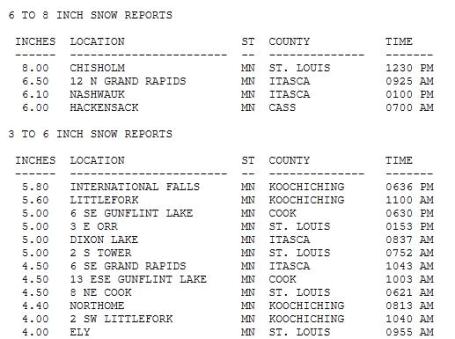
Snowfall Reports Up North. 8" was reported at Chisholm, 5" at Tower and 4" at Ely. Click
here to see all the snowfall totals, courtesy of NOAA.
4th Snowiest Winter On Record. It's official - we just endured the 4th snowiest winter in modern-day records, since 1891. So far: 85.3" of snow has fallen - more appears imminent by Tuesday night and Wednesday morning.
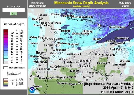
April Snowmobiling. Check out all the new snow on the ground as of early Saturday, courtesy of NOAA and
weatherstreet.com. 2-4" was on the ground north/west of St. Cloud, with some 4-6"+ amounts over northcentral and northeastern Minnesota.
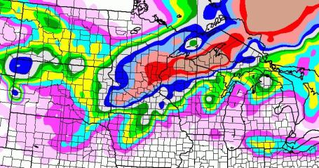
(Almost) Censored For Your Mental Health. I hesitated before sharing this with you. I do not want to ruin your Sunday.
The GFS has been notoriously unreliable in recent weeks. So why am I sharing this with you? First of all, I'm not sure I want to get into the habit of withholding information. Secondly, I'm covering my butt, just in case we're knee-deep in slush by Wednesday morning and Minnesotans are shouting "there was no warning!" Do I think we'll get a foot of snow? No, but "a few inches" seems realistic late Tuesday into Wednesday morning, with a 1 in 3 chance of a plowable snowfall. Yes, I hope the GFS solution is wrong. But one of these storms the law of averages will catch up with us. Somehow I think we have one more (significant) snowfall brewing before we finally make a turn into a sustainable spring pattern.
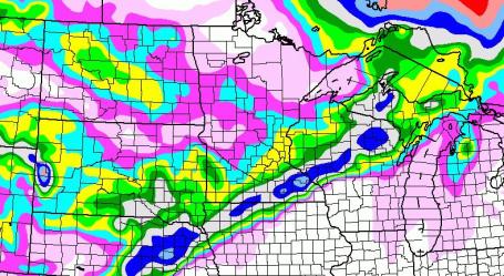
NAM Solution. I suspect the 00z NAM solution will wind up being a little closer to reality, still hinting at 2-4" slush for the Twin Cities metro, less over central Minnesota. A band of 6-10" is predicted over far southeastern Minnesota. Good grief. Some spring...
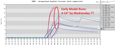
Snowy Trends. The models agree on the timing of the next storms (late Tuesday through midday Wednesday), but not the amounts. The range: 4-14", give or take a foot. Throw out the highest and lowest values and you still wind up with a midrange prediction in the 4"+ range. We'll see. It's still (very) early to be attaching inch-amounts to the forecast. Could it be "plowable"? Absolutely.
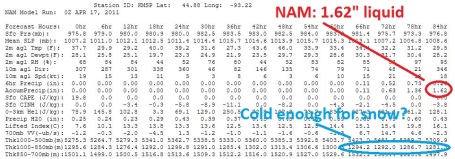
NAM Numbers. The 00z NAM is predicting 1.62" liquid by Wednesday morning, with 850-1000 mb temperature averages cold enough for mostly snow by Tuesday night and Wednesday morning. We'll see - the models WILL change as new data initializes the simulations, as newer, better, more accurate data is factored into the model runs as we get closer to the actual storm event.
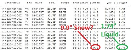
"Cobb Method". Using 00z NAM numbers one of the more reliable conversation techniques suggests 9.9" snow by Wednesday morning. I still think this is on the high side. I PRAY it's on the high side. I want to see a few more runs, see if there is any continuity from run to run, any consistency between the various models (which increases our comfort level). It's still too early to panic (or celebrate). Even the most hard-core snow lovers are probably ready to turn the page right about now.
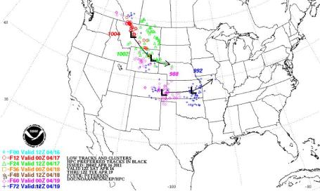
Storm Track. The models are fairly consistent in printing out a projected storm track well south of Minnesota (keeping us on the cold, northern side of this intense area of low pressure). The storm is predicted to be centered west of Kansas City within 72 hours, by Tuesday morning.
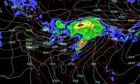
Midnight Tuesday Night. The 00z NAM solution shows a strong storm over northwestern Illinois by midnight Tuesday night, a broad shield of moderate to heavy snow stretching from central MInnesota into northern Wisconsin.
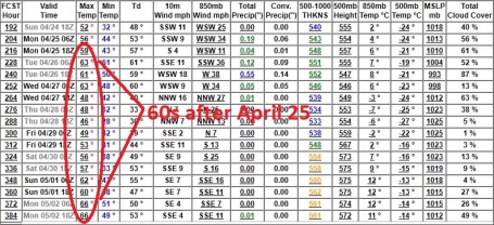
Hope. After we muddle through an unseasonably cold, stormy, potentially snowy week, models show a significant warming trend after Monday, April 25, a streak of 60s, even a shot at 70 by May 1. Wouldn't that be nice! This is 3 days/row that the GFS has been hinting at a real shift in the pattern by the last week of April - I think it's real. We're going to need a real warm front soon.
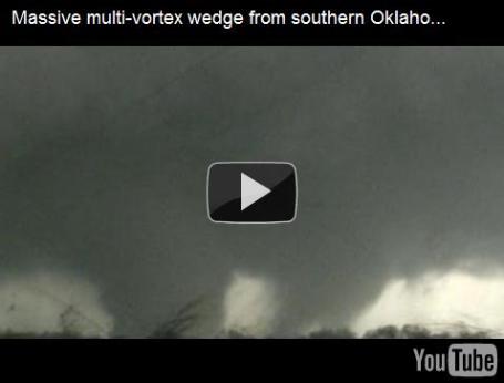
Massive Multi-Vortex Wedge From Oklahoma. This is some of the most spectacular tornado video I've ever seen, courtesy of
tornadovideos.net: "
Storm chasers/meteorologists Marc Austin, Robert McIntyre and Gabe Garfield documented and reported this violent multi-vortex tornado that struck areas in and around Tushka and Atoka, Oklahoma on April 14, 2011. They ultimately abandoned the chase to assist with first responders. Sadly, extensive damage resulted in these communities, and at least two fatality has been confirmed, along with a number of injuries."
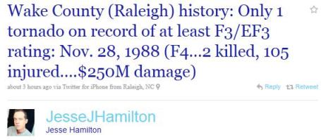
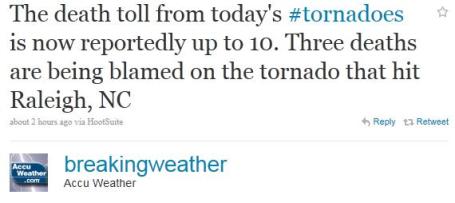
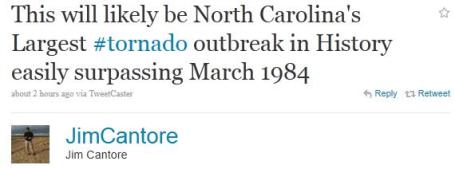
An Historic Day For North Carolina. At last report at least 80 tornadoes swept across North Carolina yesterday, setting a new statewide record for twisters in one day.
Aftermath. The tornadoes that tore into the Raleigh, North Carolina were especially violent and long-lived, possible EF-3 strength. At least 3 deaths were reported in the Raleigh area, but is expected to rise as first responders sift through the rubble. The Atlanta Journal Constitution is reporting a death toll of 24 in North Carolina and Virginia, more details
here.
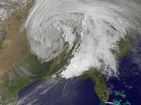
Super-Storm. Here is what Friday's deadly tornado outbreak looked like from space, courtesy of NOAA's GOES weather satellite. Jeff Masters has a summary of the outbreak (100 tornadoes in one day on Friday) in his
Wunderblog:
"Dozens of tornadoes and dangerous severe thunderstorms tore through the Southeast U.S. on Friday, bringing a second day of severe weather havoc to the nation. The death toll from the two-day severe blitz now stands at seventeen, with up to 100 people injured and tens of millions of dollars in property damage. NOAA's Storm Prediction Center logged 98 tornado reports yesterday, bringing the two-day total for the outbreak to 120 tornadoes. These preliminary reports are usually a 15% over-count of the actual number of tornadoes, which still means over 100 tornadoes have probably touched down during the past two days. The deadliest tornado of the outbreak hit near Prattville, Alabama at 10:55pm CDT last night, killing three people in a mobile home, and injuring four others. One of the most damaging tornadoes occurred just west of Jackson, Mississippi, when a tornado touched down just south of I-20, crossed the expressway, flipping cars and semis, then plowed through the town of Clinton. At least nine people were injured in Clinton, and extensive damage characteristic of an EF-2 tornado is apparent in damage photos."
Hyper-Active Storm Pattern. Fred Allen from Earth Networks has an incredible storm summary from April 14-16:
Total # of Tornadoes: 214
Total # of Wind Reports: 360
Total # of Large Hail Reports: 341
Overall # of Severe Weather Incidents Since Thursday: 915
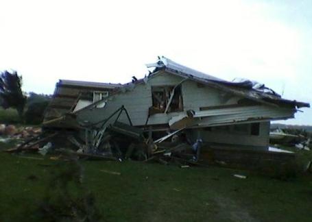
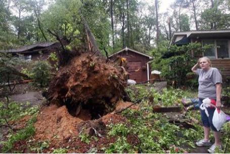
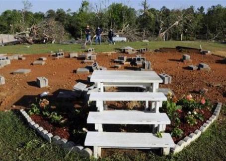
Why You Don't Want To Be In A Mobile Home During A Tornado. Winds as low as 80-90 mph can cause a mobile home to lift up off the ground. An estimated 30-40% of all tornado fatalities are people in mobile home parks who aren't able to reach an underground shelter in time. Here's a
recap of one such tragedy in Alabama on Friday from MSNBC: "
Only stairs and flowers remain Saturday, April 16, 2011 after severe winds tore a mobile home off it's lot late Friday night in Boone's Chapel, Ala., in Autauga County. Vicious storms and howling winds smacked the Deep South, killing at least seven people in Alabama including three family members whose homes were tossed into nearby woods."
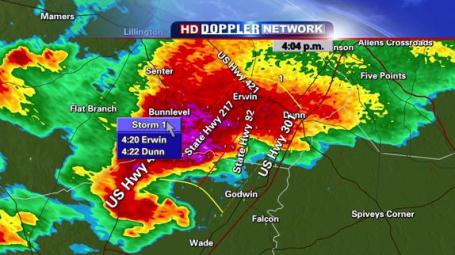
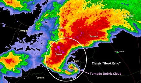
Live Coverage. Local TV stations did a good job yesterday providing blow by blow accounts of the tornadic storms roaring across North Carolina. The live Doppler image above was from WRAL-TV, which was streaming the outbreak live on the web. Note the classic hook echo just northwest of the town of Wade, a severe, rotating "supercell" thunderstorm.
Doppler Reflectivity. The radar beam (.5 degrees above the horizon) reflects (scatters) off of raindrops and hailstones, sending back a real-time snapshot of the storm, showing heaviest rain and hail, and the classic, "6" shape of a hook echo. This is the supercell that spawned a deadly "family" of tornadoes just south of Raleigh, North Carolina.
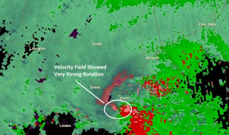
Velocity Field. Doppler radar is so sensitive it can determine whether a "target" (raindrop or hailstone) is moving toward, or away from the radar site - using algorithms the radar system can detect areas of strong rotation - this is where tornadoes are most likely to develop.
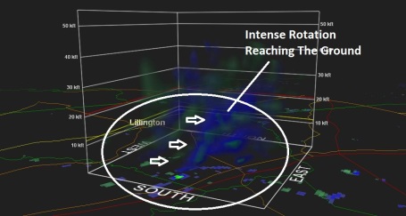
Rotation. Using a powerful analysis tool, GR2 Analyst, meteorologists were able to determine that intense rotation in the mid-levels of the atmosphere extended all the way to the ground, increasing confidence that tornadic circulation was, in fact, on the ground. This is a great tool, but no replacement for law enforcement and professionally trained SKYWARN spotters, able to confirm that rotation is spinning up an actual wall cloud, funnel or tornado.
"
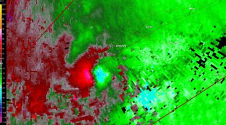
Couplet". Here is another stark example of what a tornadic "supercell" thunderstorm looks like on Doppler radar. The bright red sploch shows rain drops and hailstones moving away from the Doppler radar at high velocity, the light green/blue shades depict air racing toward the radar site. You can infer violent rotation at the intersection of those 2 colors - this iis where the tornado south of Raleigh was located. Check out more images from
texasstormchasers.com.
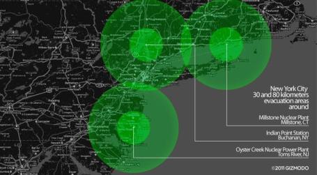
How A Fukushima-Level Disaster Might Impact New York, Chicago or Los Angeles. How might a nuclear disaster near one of America's largest urban centers play out? Gizmodo runs the scenarios in
this article: "
The Japanese government has expanded the long-term evacuation radius around the Fukushima nuclear plant to 30 kilometers (18.6 miles). The United States government is still asking to all their citizens inside an 80-kilometer radius to leave. That's almost 50 miles. If the federal government followed the same policy in US soil, these would be the consequences in the three most populated cities: New York, LA and Chicago. The maps show the nuclear power plants closest to these cities. In the case of New York, more than 20 million people in the metro area would have to be evacuated, leaving the city deserted, from Long Island to the Bronx. If there were a Fukushima-level accident at Indian Point, including the release of massive quantities of highly radioactive water, the city would be even more affected because of the Hudson River."

! Have you noticed this? You're carring on a civil conversation and all of a sudden the person you're having a "chat" with whips out their iPhone or Android trinket and starts banging away, glancing up at you with one eye. "Hey, I'm multi-tasking!" O.K. Excuse me while I walk away. Here's a good
encapsulation of today's lack of electronic etiquette from the New York Times: "
You are at a party and the person in front of you is not really listening to you. Yes, she is murmuring occasional assent to your remarks, or nodding at appropriate junctures, but for the most part she is looking beyond you, scanning in search of something or someone more compelling. Here’s the funny part: If she is looking over your shoulder at a room full of potentially more interesting people, she is ill-mannered. If, however, she is not looking over your shoulder, but into a smartphone in her hand, she is not only well within modern social norms, but is also a wired, well-put-together person. Add one more achievement to the digital revolution: It has made it fashionable to be rude."
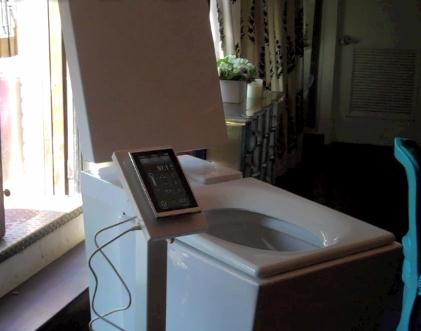
I Sat On A $6,400 Toilet Seat, And It Changed My Life. O.K. This is definitely over the top, and I think it's ridiculous to spend that kind of money on a toilet...unless it came with a portable stand for my iPad2, maybe a small HDTV attachment, possibly a small, portable 'fridge? No - this is wrong. Gizmodo.com has the decadent story: "
Let's get one thing straight—Kohler's Numi toilet isn't for you. Unless you're a Saudi oil sheik, lottery winner, or generally filthy rich person, you won't consider a toilet that costs half a year's rent. But it's spectacular. The Numi sticks every conceivable luxury into one pisser. Things you didn't even think you needed—and things you definitely don't need—a foot warmer, radio, auxiliary audio input, ambient lights. And all controlled by a touchscreen mini-tablet with a 20 foot range. Why would you ever need to control your toilet from 20 feet away brings up a series of nightmare scenarios that are hard for me to express right now, but good to know, just in case. But beyond the decadence, there's some really great design ($6,400's worth, I'm not so sure, but still). A motion detector, indicated by a blue spotlight, allows you to raise and lower the seat with a foot-tap—a victory for all of lazy mankind."
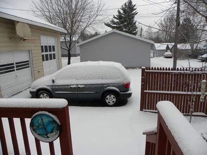
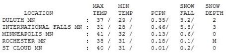
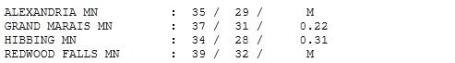
Raw Saturday. If felt more like March 16 out there yesterday with a gray sky spitting a few snow flurries. Highs ranged from a chilling 31 at International Falls (digging out from nearly 6" of snow) to 40 at St. Cloud, 41 in the Twin Cities.
 Paul's Conservation Minnesota Outlook for the Twin Cities and all of Minnesota:
TODAY
Paul's Conservation Minnesota Outlook for the Twin Cities and all of Minnesota:
TODAY: Intervals of sun, less wind. It will almost feel like spring. Winds: NW 7-12. High: near 50
SUNDAY NIGHT: Partly cloudy, chilly. Low: 34
MONDAY: Mostly cloudy - still dry. High: 48
TUESDAY: Rain develops, changes to wet snow. Snow may be heavy Tuesday night. Low: 35. High: 41
WEDNESDAY: Wet snow tapers. A few inches possible, possibly "plowable" early. Low: 32. High: 42
THURSDAY: Clouds increase, a cold rain late? Low: 33. High: near 50
FRIDAY: More rain possible (wet snow up north?) Low: 36. High: 45
SATURDAY: Showers taper, slow clearing, still unseasonably cool. Low: 33. High: 48
Weather Therapy
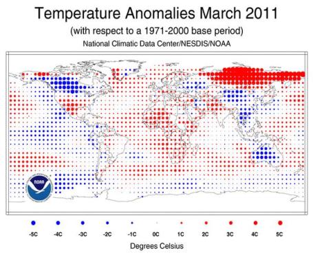
"The Earth experienced the 13th warmest March since record keeping began in 1880, as the climate phenomenon La Niña continued to be a significant factor. The annual maximum Arctic sea ice extent was reached on March 7 and tied with 2006 as the smallest annual maximum extent since record keeping began in 1979", said a recent NOAA release. La Nina springs tend to be volatile: on Friday 100 tornadoes were observed from Illinois to Alabama. The trends are obvious: it's turning into a deadly and violent spring for much of America. I just can't envision a scenario where Minnesota would see more tornadoes than last year (a nation-leading 113.) But with imminent warmth & humidity will come a growing severe risk from late April into May. As much as we dread the slush and wind chill, at least we're not spending quality time hiding in our basements.
It's now the 4th snowiest winter season on record; a few of the models are hinting at a major snow Wednesday, but the more reliable ECMWF solution kills the storm; whisks it east. Hope it's right. Not sure how much more snow we can take before demonstrators take to the streets.
I see a run of 60s after April 26. Keep the faith.
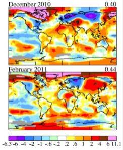
Arctic Temperatures Off The Scale. A good summary of Arctic temperature trends
here: "
Warmer than average temperatures prevailed across much of the planet in March, especially in the far north, where readings were so high that climatologists had to add a new color — hot pink — to their maps. Overall, the combined global land and ocean surface temperature was 0.88 degrees above the 20th century average, making it the 35 consecutive March with above-average temperatures and the 13th-warmest March on record, according to the monthly summary from the National Climatic Data Center. For the year to-date, global temperatures are running 0.77 degrees above average, making it the 14th warmest January-March period on record. Warmer-than-average ocean conditions were most pronounced in the equatorial Atlantic, the western Pacific oceans, and across the Southern Hemisphere midlatitudes. Across the planet’s land masses, the most prominent warmth was recorded across most of Siberia, southwestern Greenland, southern North America, and most of Africa. Cooler-than-average conditions were reported from the western half of Canada, most of Mongolia, China and southeastern Asia. A notable exception to global warmth was in Australia, which experienced its coolest March on record, with above average rainfall across the entire country."

. The Montreal Gazette
examines life in a world that is 2 degree Celsius warmer than today: "
Not that he or anyone else wants to see the Earth's average temperature climb by 2 degrees Celsius. Wet places would get wetter. Extreme weather would be more extreme. Dry spots would be plagued by drought, and some crops would fail. Nine out of 10 summers would be hotter than the hottest summer in the last 20 years. There would be more forest fires. Sea ice would melt, coral reefs would be in peril. Birds, animals and plants unable to adapt or migrate to cooler terrain would risk extinction. Yet geographers, environmental scientists, urban planners, climatologists - people like Matthews who spend their days worrying about what has already happened to the planet and what's likely to occur if we keep pumping greenhouse gases into the atmosphere - have begun to see containment as their last, best hope."
The Key To Sustainability. Chairman of the Intergovernmental Panel on Climate Change (IPCC), Rajendra Pachauri, addressed an audience at the University of Delaware, sharing potential solutions to the problem of climate change. Here is an excerpt of his
remarks: "
Addressing charges by climate change skeptics that the observed increases in the surface temperature of the Earth could be the result of natural variations, Pachauri referred to a graph depicting the range of predictions by climate models that include both natural and human forcing mechanisms or natural mechanisms alone. “Natural factors such as solar activity and volcanic activity don’t fully explain what has happened to temperature increases over the past 100 years or so,” Pachauri said. “However, when we include inputs related to increases in the concentrations of greenhouse gases, what we get is almost a perfect fit between model predictions and actual observations.” Pachauri also reviewed the expected impacts of climate change on human societies in the coming century. “For thousands of years, human societies have been based on a steady supply of water from seasonal melting of glaciers,” he said. The reduction of ice stored in glaciers is now expected to place numerous societies at increased risk of water stress and conflict based on shrinking water supplies for drinking and irrigation. Other effects include sea-level rise, which threatens to displace many millions of people who live in low-lying river deltas around the world, including the Nile, Ganges and Mekong deltas. Pachauri emphasized that the worst impacts would likely be experienced by the populations with the fewest resources available to adapt to change. “Climate change will have an impact not only on future generations, but on this generation,” he said."
China Willing To Join U.S. In Climate Change Conversation. Here's an
article from takepart.com: "
Speaker of the House Nancy Pelosi has been overseas in China as of late, trying to get the nation with whom we rarely agree to engage with the United States on the topic of climate change. And, lo and behold, it looks like it may be working. The Premier of China, Wen Jiabao, says that China is ready to join the dialogue on climate change. From Terra Daily: "China will cement policy dialogue with the United States, take the joint tackling of climate change as an important aspect of cooperation and push for positive results in the Copenhagen Climate Change Conference," Xinhua news agency quoted Wen as saying. This is pretty exciting stuff, as China has resisted multi-lateral attempts to discuss climate change and was not bound by the Kyoto protocol, which the Copenhagen Climate Change Conference will attempt to replace. Pelosi, for her part, said (prior to Premier Wen's statement) that China joining a discussion on climate change could have great implications for U.S./China relations."

No comments:
Post a Comment