5 days above 50 expected next week; temperatures should average a couple degrees above average for the first week of April.
60s possible after April 13.
Flood Warnings: Crow River at Rockford and Long Prairie River at Long Prairie.
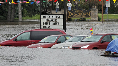
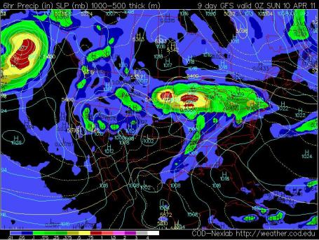
Second Crest on many Minnesota rivers possible by the 3rd or 4th week of April, the result of rapid warming coupled with significant rain in the coming weeks - the worst flooding on the Minnesota, Mississippi and Red Rivers may be yet to come.
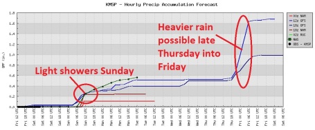
.10" rain possible from showery rains on Sunday.
1 - 1.2" rain possible the end of next week, from late Thursday into Saturday, April 9.
0" expected snowfall in the Twin Cities over the next 7 days.
Flood Warnings posted for the Long Prairie River and the Crow River:
BULLETIN - IMMEDIATE BROADCAST REQUESTED FLOOD WARNING NATIONAL WEATHER SERVICE TWIN CITIES/CHANHASSEN MN.
...THE NATIONAL WEATHER SERVICE IN CHANHASSEN HAS ISSUED A FLOOD WARNING FOR THE FOLLOWING RIVERS IN MINNESOTA...LONG PRAIRIE RIVER AT LONG PRAIRIE AFFECTING TODD COUNTY...FORECAST FLOODING CHANGED FROM MODERATE TO MAJOR SEVERITY FOR THE FOLLOWING RIVERS IN MINNESOTA...CROW RIVER AT ROCKFORD AFFECTING HENNEPIN AND WRIGHT COUNTIES.THIS RIVER FORECAST IS BASED ON CONTINUING SIGNIFICANT SNOW MELT...THE PRECIPITATION RECEIVED OVER THE LAST FEW DAYS...AND FORECAST SNOW MELT AND PRECIPITATION OUT THE NEXT SEVERAL DAYS. HEAVY RAINS COULD CAUSE FASTER SNOW MELT AND EXTRA RUNOFF THAT WILL CAUSE RIVER LEVELS TO RISE EVEN HIGHER AND FASTER THAN PREDICTED. THE NATIONAL WEATHER SERVICE WILL MONITOR THIS DEVELOPING SITUATION AND ISSUE FOLLOWUP STATEMENTS AS CONDITIONS OR FORECASTS CHANGE.
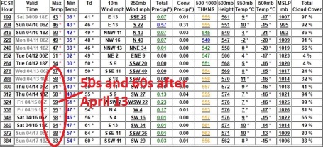
Extended Outlook: Spring Fever! It's been a long, tough winter season - but we're turning a BIG corner. Models show a string of 50s and 60s after April 13. The concern: too warm too fast, coupled with significant rain will spark another rapid melting of snow over northern and western Minnesota, resulting in rapid runoff and a possible second crest on many Minnesota rivers as early as the 3rd or 4th week of April.
RECORD EVENT REPORT
NATIONAL WEATHER SERVICE LAS VEGAS NV
941 AM PDT FRI APR 1 2011
...ALL-TIME MARCH RECORD HIGH SET AT DEATH VALLEY CA THURSDAY...
THE HIGH TEMPERATURE FOR THURSDAY AT THE OFFICIAL WEATHER STATION IN
DEATH VALLEY AT FURNACE CREEK WAS 103 DEGREES. THIS SETS AN ALL-TIME
RECORD HIGH FOR THE MONTH OF MARCH BREAKING THE OLD RECORD OF 102
DEGREES WHICH WAS RECORDED ON MARCH 28 1986...MARCH 21 2004...MARCH
16 2007 AND MOST RECENTLY ON MARCH 17 2007.


Time Warner Pulls Channels From iPad App. The New York Times reports on disruptive technology causing headaches among cable providers and the channels they beam into customer's homes. If you pay for a cable show should you be able to watch it any way you want, say on an iPad instead of a TV screen in your family room? Most people probably feel this is a reasonable assumption, but not the cable channels. The problem: Nielson (which measures viewership, critical data that determines advertising rates) can't yet measure viewership on an iPad. If you stream Stephen Colbert on Comedy Central onto your iPad Nielson doesn't know you're watching - and the cable channel doesn't get credit for you viewering their channel - you literally fall into a black hole. This could lead to declining viewership levels and reduced income from advertising - this is why these guys are so paranoid. More details: "Time Warner Cable on Thursday abruptly removed several channels from its app that replicates the TV viewing experience on an iPad. The cable company withdrew the channels, including MTV and FX, after receiving complaints from three major media companies, Viacom, Discovery Communications and the News Corporation. The companies have claimed that the iPad app is a contract violation — in part because they want cable companies like Time Warner Cable to pay them more for the privilege to stream their channels to portable devices. Viacom and the News Corporation had sent cease-and-desist letters to Time Warner Cable in recent days. The iPad, in essence, is the latest battleground for a long-running fight about how television will be delivered in the digital age, and by which companies. Time Warner Cable reaffirmed on Thursday that it believed it had “every right to carry the programming on our iPad app.”
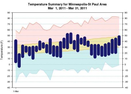
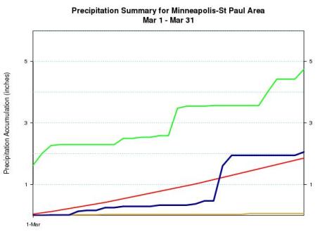
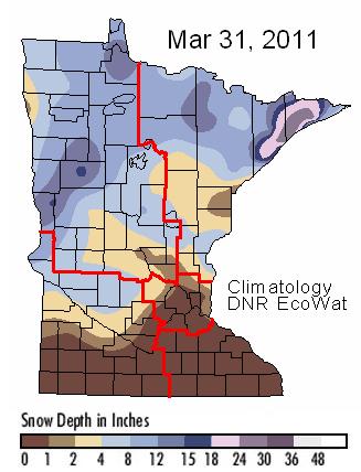
March Climate Summary. Top graph: temperature trend for March. Bottom graph: red line is average precipitation, the blue line is actual precipitation, green line is the record (1965, the worst flood year on record for much of Minnesota). Data from the Chanhassen Office of the National Weather Service: "Detailed climate summaries are now available for the month of March (links and images below). In general, the area came out about 2 to 5 degrees below normal, with precipitation near to slightly above normal. For snowfall, the March 22nd-23rd storm resulted in much of west central and central Minnesota into northern portions of west central Wisconsin seeing above normal snowfall for the month, while the rest of the area, including the Twin Cities and Eau Claire, was below normal. This stands in stark contrast to the March of 2010, when no snow was observed at any location within the MPX county warning area and temperatures ran about 5 to 8 degrees above normal."
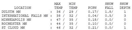

Getting Better. Under a partly sunny sky with a drying northwest breeze Friday highs ranged from a brisk 35 at Grand Marais to 46 in St. Cloud, 47 in the Twin Cities, just 1-2 degrees cooler than average for April 1, but a far cry from last year, when highs reached 81 in the Twin Cities and 77 in St. Cloud on April Fools Day.
Paul's Conservation Minnesota Outlook for the Twin Cities and all of Minnesota:
TODAY: Vague hints of spring. Sunshine much of the day. Winds: NW 10. High: 51
SATURDAY NIGHT: Cloudy with light rain possible late. Low: 38
SUNDAY: Windy and mild with a few showers (best chance morning hours). Winds: E 10-20. High: 53
MONDAY: Showers taper, turning cooler. Low: 36. High: 48
TUESDAY: Sun returns (and hope) returns. Low: 30. High: 49
WEDNESDAY: Plenty of sun, partly-springy. Low: 36. High: 56
THURSDAY: Clouds increase, with heavy rain developing late. Low: 38. High: 52
FRIDAY: Rain tapers to drizzle. Low: 39. High: 54
SATURDAY: More heavy rain as a storm passes just south/east of Minnesota. Low: 42. High: 51
SUNDAY: (April 10). Rain may mix with wet snow before tapering, windy and cooler. Low: 42. High: 46
Increasingly Feverish
Good riddance to March. Last month was 2.7 degrees cooler than average, nearly 11 degrees colder than March of 2010. La Nina (cooling phase of the Pacific) is probably to blame. We're due for a big shift in the pattern, and there are signs of relief as early as next week. My joy in 50s (and rain) is tempered by the knowledge that an "instant spring" will spark rapid melting of snow over northern and western Minnesota, flushing a new surge of water into streams & rivers.
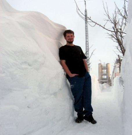
Have your camera ready: the sun makes a rare cameo appearance today, highs flirting with 50 (nice to be "average" again). Brush the cobwebs off your bike, consider a walk around the block, if I get a running start I may just be able to make it to the grill, buried for months under 5 foot drifts.
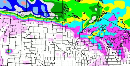
The much-advertised southern storm pushes a cold rain into Minnesota Sunday; light showers possible, with the heaviest rain (and wet snow) confined to far northern Minnesota. It may be cold enough for mostly-snow north of Bemidji, some 2-4"+ amounts possible over far northern Minnesota by Monday morning.
Sunshine returns Tuesday, a streak of 50s (!) next week. Long-range models hint at over 1" of rain next weekend, further complicating Minnesota's precarious flood scenario.

Arctic Sea Ice - A Climate Change April Fools Joke? Not According to Snopes. Here's a release that came out yesterday, courtesy of reason.com: "Interesting, since people who are concerned about climate change often cite the fact that Arctic sea ice cover has been declining at a rate of 3 percent per decade as evidence for man-made global warming. The satellite data set issued by the University of Alabama in Huntsville finds that the arctic temperature trend since 1979 is 0.47 degree Celsius per decade which is three times higher than the overall global trend of 0.14 degree Celsius per decade. The National Snow and Ice Data Center issued a this preliminary report on Arctic sea ice cover last week:
On March 7, 2011, Arctic sea ice likely reached its maximum extent for the year, at 14.64 million square kilometers (5.65 million square miles). The maximum extent was 1.2 million square kilometers (463,000 square miles) below the 1979 to 2000 average of 15.86 million square kilometers (6.12 million square miles), and equal (within 0.1%) to 2006 for the lowest maximum extent in the satellite record."
James Inhofe Apologizes For Calling Global Warming A Hoax. Shocking news on April 1: "In what might be one of the most remarkable about-faces ever to come from within the beltway, James Inhofe, Senator and minority ranking member of the Environment and Public Works Committee (R. OKLA), apologized to a stunned Senate chamber for calling climate change the “greatest hoax ever perpetrated on the American people.” “It’s time for leadership in Washington on climate change,” said Inhofe. “To date, I have been an obstacle to that leadership, and that changes today.” A confused and bewildered Republican leadership called for the Senate Sargent at Arms to restore order – “this man is not who he says he is!” cried Senate minority leader Mitch McConnell, accusing Inhofe of being a liberal hollywood stunt double carrying out an evil socialist plot. The befuddled McConnell then made a choking sound, suddenly blurting out the word “Hitler!” Inhofe tried to reassure and calm his colleagues. Turning to McConnell he said, “Calm down Mitch, it’s really me. I’m no Hitler, nor is Obama or any of my colleagues on the left. It’s time we stopped this hurtful and dangerous rhetoric and worked to solve problems. Global warming and a new energy economy are now at the top of my list.” At that McConnell collapsed on the Senate floor and and was rushed to the hospital."

No comments:
Post a Comment