2002 last year we had snow reported this late in the season.
1991 last year we had measurable snow in May in the Twin Cities.
44 F. high in the Twin Cities yesterday (average high is 63).
48 F. yesterday's high in Anchorage, Alaska.
35 F. high in Duluth (where 1" of new snow fell).
* 136 tornado reports on Wednesday (SPC). That number will change as NWS field crews survey damage today.
148 tornadoes: all-time record for number of tornadoes in a single day (April 3, 1974).
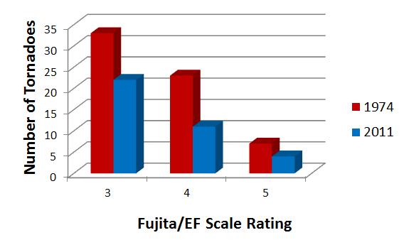
Yesterday's Outbreak Rivaled The All-Time Record "Super Outbreak" of April 3, 1974. 148 tornadoes were observed that day, including 30 F4's and 6 F5's.
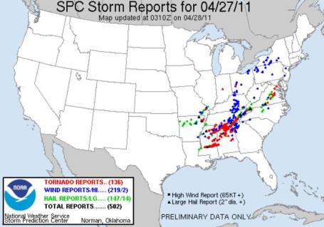
A Convulsion Of Tornadoes. As of 10:30 pm last night 136 tornadoes had been observed from Mississippi to Maryland. This count may be adjusted upward or downward as teams of NWS employees are dispatched into the field. The latest rundown is here.
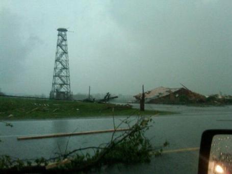
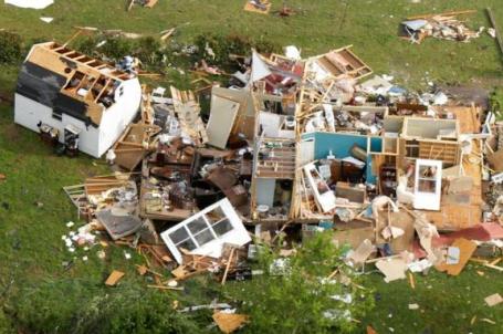
Update From the New York Times: "At Least 54 Dead in Storms Across South A deadly tornado stretching a mile wide tore through downtown Tuscaloosa, Ala., on Wednesday evening, destroying homes and buildings and bringing further damage to a region already battered by storms. Across the state, at least 25 people were killed by storms on Wednesday alone, said Valerie Hayes, a spokeswoman for the Alabama Emergency Management Agency. But that number did not include any deaths from Tuscaloosa, where 15 people were confirmed dead by the mayor's office and 100 were said to be injured, The Tuscaloosa News reported. Earlier in the day, with the damage spreading and the death toll rising, Gov. Robert Bentley declared a state of emergency. And The Associated Press reported that across the South, storms Wednesday killed 11 people in Mississippi, two in Georgia and one in Tennessee."

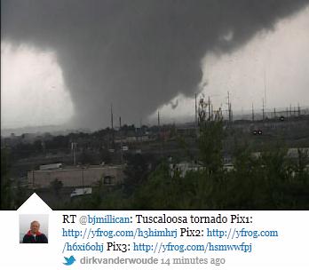
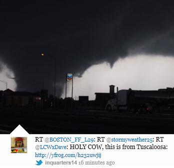
Tuscaloosa, Alabama Tornado. An amazing sequence of photos of the large, violent tornado that ripped through Tuscaloosa, Alabama late Wednesday below, courtesy of storify.com.
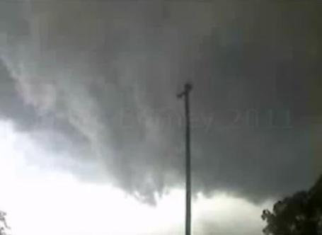
"Wedge". Here's some remarkable video, shot by Crimson Tide Productions, another view of the massive, wedge tornado that leveled portions of Tuscaloosa, courtesy of Vimeo. That was a 1/4 to 1/2 mile wide "multi-vortex" wedge tornado - as many as 4-6 smaller tornadoes all rotating around a common center. For local Tuscaloosa residents it must have looked like the end of the world. This is the same tornado that hit Birmingham. (More tornado information below).

Late Spring Slush. Nothing brings out Minnesota Nice faster than fresh snow on green, freshly-mowed lawns. According to Pete Boulay over at the Minnesota State Climatology Office the last time we had measurable snow this late in the season was 2002. Boulay goes on to add that "we have not had measurable snow in May since 1991." Let's hope that record remains intact. Details:
http://climate.umn.edu/text/prelim_lcd/mpx/mpxapr2002.htm
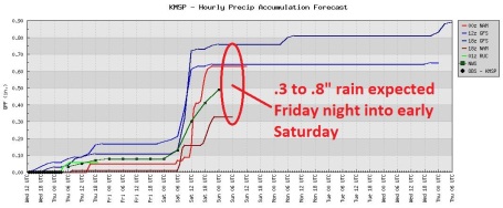
Friday Night Showers. The models all differ on how much rain will fall, but there's little doubt that a period of rain is likely Friday night into the morning hours Saturday morning. The models print out anywhere from .3 to .8" rain.
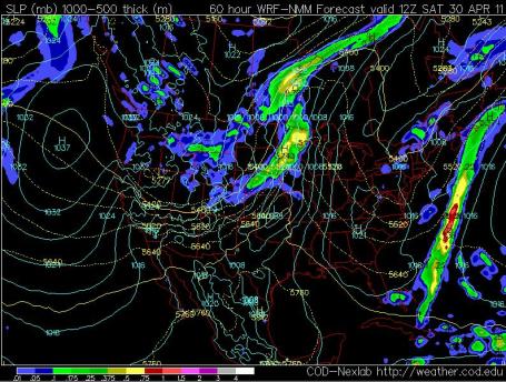
Saturday Morning Puddles. I wish I had some better news, but there's a good chance we'll wake up to a few hours of rain Saturday morning. The NAM model, valid 7 am Saturday, shows a 75-100 mile wide band of showers (and possible thundershowers) pushing across the state of Minnesota Saturday morning. A northwest breeze will begin to dry us out by afternoon, a chance of spying the sun by late afternoon/evening, especially over western Minnesota.
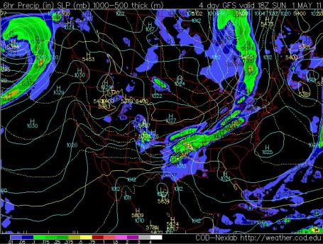
Sunday: The Better Day. A weak ridge of high pressure sails overhead Sunday, meaning a good chance of sunshine, especially morning and midday hours. Clouds may increase Sunday afternoon with an isolated shower possible late in the day, best chance far western Minnesota. Map above is the GFS model, valid 1 pm Sunday afternoon.
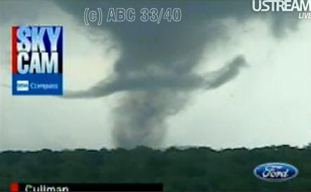
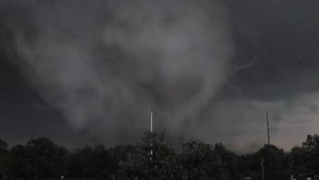
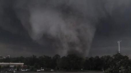
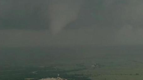
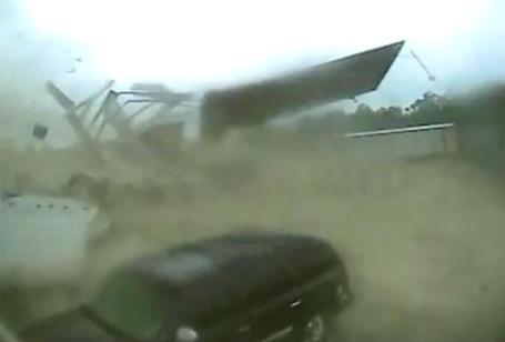
Cullman Mississippi Tornado. Top image from a webcam, bottom image is a frame-grab from ABC 33/40's helicopter, of the massive tornado that slammed into Cullman Wednesday afternoon.
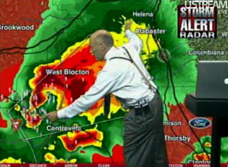
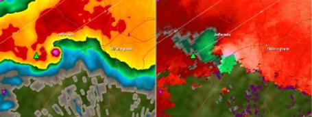
"Debris Ball." It is incredibly rare to see an actual tornado on Doppler radar. Late Wednesday, around 6:35 pm, James Spann, meteorologist at ABC 33/40 in Birmingham was tracking a "debris ball", the actual debris field composed of pieces of homes, trees, cars - THE ACTUAL TORNADO ITSELF - is showing up on the station's Doppler Radar. Only a large, violent tornado would be capable of this. In this frame-grab Spann is pointing to the actual tornado debris. Debris was carried as far as 115 miles downwind from the tornadoes - people several counties away reporting a "shower of debris". I can't remember the last time I saw this...
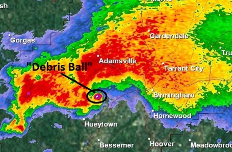
More Debris. Here's a reflectivity view from Birmingham (NWS) Doppler around 6:30 pm Wednesday, showing a 1/2 to 1 mile wide tornado. The energy beam from the Doppler is actually reflecting off debris swept up in the tornado. Absolutely incredible.

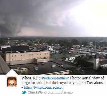
Tuscaloosa, Alabama Tornado. Another tower-cam frame-grab from ABC 33/40, courtesy of Severe Studios.
Another Perspective. "@spann tornado in Tuscaloosa about 40 minutes ago. Taken from south of Hillcrest High School. http://t.co/zhDeld0."
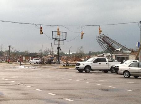
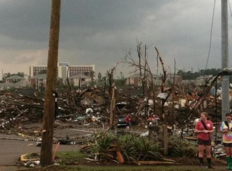
Aftermath. It looks like a bomb dropped on Tuscaloosa, image courtesy of plixi.com and yfrog.com.
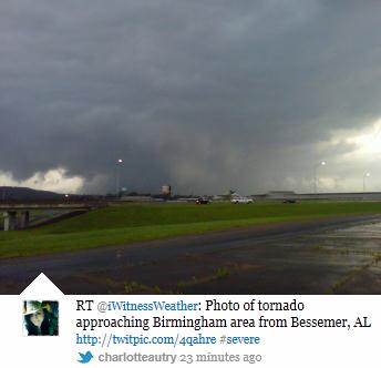
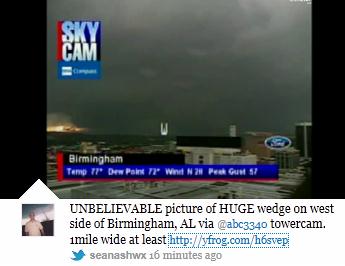
Birmingham Tornado. Wednesday, around 6:15 pm central time, a massive "wedge" tornado formed on the west side of Birmingham. Details: "LARGE Mile wide tornado moving into the downtown Birmingham AL area http://yfrog.com/h7b5ztp."
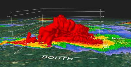
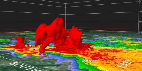
Visualizing A Tornado In 3-D. Using the GR2 Analyst tool, meteorologist Todd Nelson captured these images of the violent rotation west of Birmingham, Alabama around the dinner hour Wednesday. The technology available today (even for the armchair weather enthusiast thousands of miles away) is truly impressive.
Birmingham Wedge Tornado. The preceding series of images brought to you by a powerful new tool for vetting social media called "Storify."
Funnel Forms Live, On-Air. Here's a clip from the NBC affiliate's news helicopter in Dallas on Tuesday as a tornado formed, live, on the air: "A funnel cloud tried to form into a tornado near Cleburne State Park live during storm coverage on NBC 5. (The video clip was 3 minutes and 30 seconds long, we sped it up the video is now a little over 1 minute in length.)"
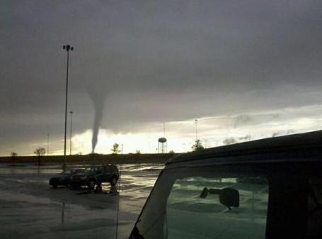
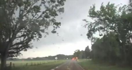
Rare Morning Tornado. Here is a photo of a tornado on the ground near the Eastgate Mall in the Cincinnati area Wednesday morning. Photo credit: Jeremy Moses and plixi.com.
"Tornado Emergencies." The only thing more urgent than a tornado warning is a "tornado emergency". These are extremely rare, only issued when a large, violent tornado is confirmed on the ground, and moving into a populated area. More details from the weather geeks over at Wikipedia: "Since its first use in 1999, the National Weather Service (NWS) has used the Tornado Emergency text in at least 70 bulletins, sometimes multiple times on the same day. For instance, during the 2008 Super Tuesday tornado outbreak, Tornado Emergencies were mentioned in twelve separate bulletins in Tennessee and Alabama. Below is a listing of all known Tornado Emergencies issued in the United States to date."
Tornado Caught On Security Video. An amazing clip from the EF-1 tornado that touched down late Tuesday near Collins, Mississippi. "Apr 26 - Security cameras in southern Mississippi capture the moment a tornado touches down, tearing the roof off a building and hurling debris around. Rough cut (no reporter narration)."
Wall Cloud Spinning Up A Funnel. Here's a YouTube clip shot south of Van, Texas on Tuesday.
All That's Missing Is A Flying Cow. Another YouTube clip, this one from near Holly Springs, Texas on Tuesday. A large, multi-vortex "wedge" tornado is beginning to form, and these chaser have every reason to be excited!
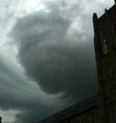
An Ominous Sight. Check out this developing funnel cloud spotted over Rhodes College in Memphis, taken Tuesday night - courtesy of twitpic.
Missing Doppler Radome. "Shocking photo of WAFF-48's Doppler radar missing from its mast in northern Alabama."
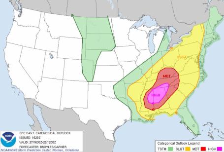
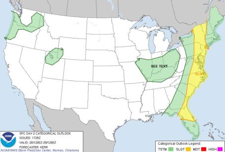
High Risk. Meteorologist Andy Mair has a summary of SPC's issuance of "high threats". The map above shows the high risk area issued by SPC on Wednesday, one of the violent days of the year so far. More from Wikipedia here.
*There have only been 86 "HIGH RISK" days since 1984 (including today's HIGH RISK)*
*We average a little over 3 "HIGH RISK" days a year*
*There have only been 4 years with no "HIGH RISK" days (1985, 1986, 1987 & 2000)*
*Most "HIGH RISK" days issued in one year was 1999 - 7 days*
*There have only been 8 back-to-back "HIGH RISK" days since 1984 (including April 26th & 27th 2011)*
*There have been 27 "HIGH RISK" days in the month of April Since 1984 (including 2011)*
*31% of all the "HIGH RISK" days issued since 1984 have been in the month of April*
*31% of all the "HIGH RISK" days issued since 1984 have been in the month of May*
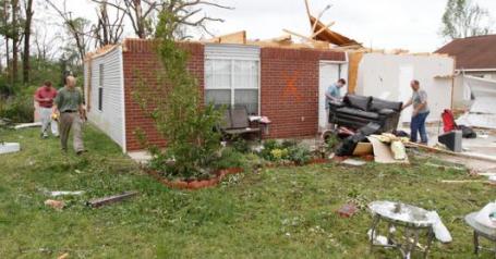
Deadly Storms Leave Arkansans Battered And Bracing For More. An update on the atmospheric carnage from the New York Times: "VILONIA, Ark. — A barrage of severe weather sweeping across Arkansas has brought flash floods to some parts of the state, wrecked this small town and left 10 dead. Residents braced for more damage on Tuesday evening as violent storms washed across the state. By Tuesday afternoon, the storms had left about 45,000 people without power and destroyed scores of homes. Tens of thousands more, many in the Memphis area, lost power Tuesday as the storms moved east. In Faulkner County, Ark., alone, 60 homes had been destroyed and 51 had sustained major damage, said Shelia Maxwell, director of the Faulkner County Office of Emergency Management. Six of the 10 deaths were due to flash flooding in northwest Arkansas. Four people were killed by a tornado that touched down and marched through Vilonia, a small town amid farmland a few dozen miles north of Little Rock."
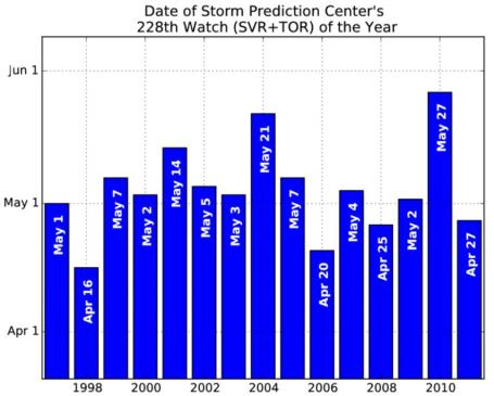
Severe Weather On "Fast-Forward". The Iowa Environmental Mesonet has a post about the frequency of severe storm watches being issued by SPC, the Storm Prediction Center: "The nation's recent stretch of severe weather continues with a high risk of severe weather issued today over portions of Alabama. The Storm Prediction Center has issued its 228th watch of the year this morning. Last year, it took until the 27th of May for the 228th watch of the year to be issued as shown by the featured chart. Three other years since 1997 have seen more watches issued by this date than this year."
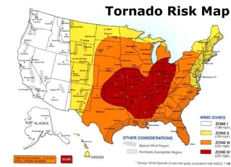
Tornado Risk. Some interesting facts from the Kansas City Metro Area Storm Shelter Plan: "The Federal Emergency Management Agency (FEMA) has classified the Kansas City region as in the wind zone IV. This is the highest classification of wind zones and signifies the greatest threat. Wind zone IV translates to a threat of winds up to 250 miles per hour during a severe storm. See wind zones image. In addition to having a record of strong winds in the region, we tend to have more violent storms on a frequent basis. FEMA has designated the Kansas City region in the highest level for storm intensity per square mile. Please refer to tornado activity image above. From this information, it is clear that severe storms and tornadoes are a significant threat to the region and worth taking into serious consideration."
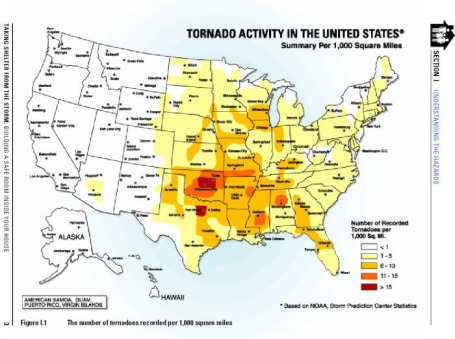
Tornado Activity In The United States. Far southern Minnesota experiences an average of 6-10 tornadoes per 1,000 square miles, rivaling the tornado frequency of Iwa, Missouri and parts of Kansas. The most tornado-prone region of the USA: central Oklahoma, parts of Texas, and the Lower Mississippi Valley: "Tornadoes have caused one death and 6.6 injuries every 16 months during the past 56 years in the five county Missouri MARC region (Regional Natural Hazard Mitigation Plan, 2004). It has also been concluded that residents of the motel and hotel industry, mobile home community, and single family dwellings without basements are at the most significant risk from these storms (Merell, 2005). These populations are at an even greater risk considering most tornadic activity takes place between 3 p.m. and 9 p.m. (National Weather Service). During this time people have a tendency to be at home, which could be one of the above mentioned facilities."
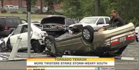
Five Dead As Storms Pound South For Second Straight Day. NBC's Today Show has a video update on the violent weather sweeping much of the south: "VILONIA, Ark. — At least five people are dead from Arkansas to Alabama as a second day of storms and tornadoes crossed the South. The latest round of severe weather Tuesday night and early Wednesday came a day after a series of powerful storms killed 10 people in Arkansas and one in Mississippi. At least three people died in Mississippi, including a police officer hit by a tree limb as he shielded his daughter during a camping trip. Officials in Choctaw County, Miss., said the daughter was not hurt. One person died when a tree fell on a car in north Alabama. A Cullman County sheriff's spokesman said Wednesday that emergency responders were working to free another person from the car. Also in Mississippi, a man was crushed in his mobile home when a tree fell during the storm and a truck driver died after hitting a downed tree on a state highway. None of the victims have been identified.
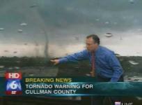
Maryland Tornado. As many as 60-100 tornado warnings may have been issued Wednesday afternoon/evening, from Mississippi and Alabama to Maryland. A Capital Gang meteorologist, Michael Bell, was in line at Chipotle and witnessed this tornado touchdown near Clinton, Maryland.
Today's Storm Risk. The threat of severe weather, including tornadoes, diminishes significantly today, although a dozen or more tornadoes can't be ruled out from the Florida Panhandle northward to Vermont, according to SPC.

Skywarn Classes In The Twin Cities. Are you a serious weather enthusiast? The National Weather Service is looking for volunteers who can assist during severe weather episodes. Some professional training is required, but you can be one of hundreds of people in Minnesota deployed to monitor the skies and assist with the issuance of severe storm and tornado warnings. Doppler radar only goes so far - we still need "ground truth", trained spotters who can confirm the formation of severe weather, time-sensitive information that helps the local NWS office with warnings. The home page for Metro Skywarn is here. More information from the local NWS office: *For Skywarn training in the Twin Cities Metro Area, the Metro Skywarn group also conducts Skywarn Training classes, taught by Metro Skywarn instructors. They are offering over 20 classes in the Twin Cities metro area this spring, and a schedule of those classes can be found by clicking here. Skywarn training classes on this schedule are all free, and last around 2 1/2 hours. Pre-registration for these classes is required only if specifically stated on this schedule. Additional classes will be added to the list if local officials request a class in their area. For more information on the Skywarn program, click here."
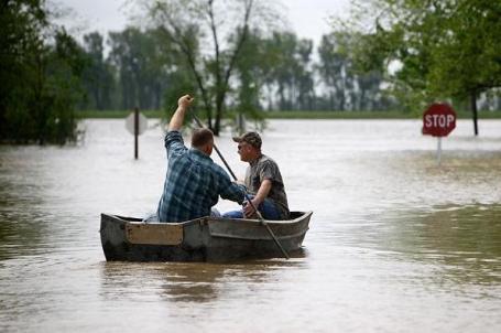
Corp: Wait For Weekend To Decide On Levee Break. The Southeast Missourian has an article about the Army Corp of Engineers debating whether they should destroy a levee to protect a nearby town: "SIKESTON, Mo. (AP) -- An Army Corps of Engineers spokesman said Wednesday the agency will wait until this weekend to decide whether it is necessary to punch a massive hole in a levee to protect an upstream Illinois town from the rising Mississippi River. The corps has said it may have to blow holes, perhaps using explosives, in the Birds Point levee to ease rising waters near the Illinois town of Cairo (KAY'-roh), which sits near the confluence of the Ohio and Mississippi rivers. Missouri has filed a federal lawsuit to block the effort because it would swamp farmland. A hearing is scheduled for Thursday. But corps spokesman Bob Anderson told The Associated Press that even if a judge gives the go-ahead, the agency will wait until it gets a better forecast of the river crests to see if the breach is necessary. That decision isn't likely to come until at least this weekend. Missouri government leaders argue the levee's destruction would flood up to 130,000 acres of land - an area stretching 30 miles north to south and as much as eight to 10 miles wide at certain points. Missouri Attorney General Chris Koster says floodwaters would leave a layer of silt on farmland that could take a generation to clear and also could damage 100 homes."
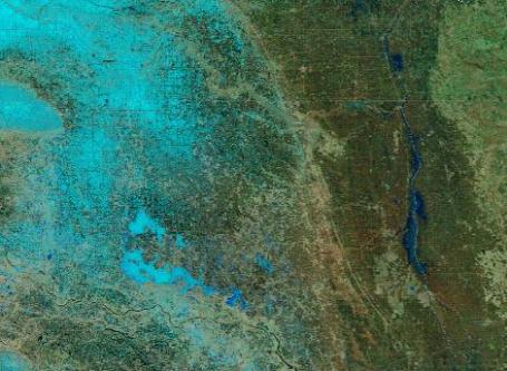
Flooding Continues Along The Red River Of The North. Here is a false-color NASA "MODIS" satellite image taken on April 11.
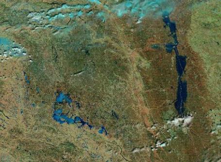
After Shot, Taken April 24. Check out the area of flooding to the right of the photo; more details from the U. of Wisconsin CIMSS site: "A comparison of MODIS false color Red/Green/Blue (RGB) images from the SSEC MODIS Today site (above) shows the increase in areal coverage of flooding along the Red River of the North, from north of Grand Forks, North Dakota into southern Manitoba. Also evident is the melting of most of the snow cover across northeastern North Dakota, and the melting of portions of Devils Lake (snow and ice appear as cyan features on the false color images, while water has a darker blue appearance)."
Why Google, Apple Are Tracking Your Location. We're all quickly discovering that nothing (good) is "free". The tech monoliths of the world provide free service in the expectation that you will give up enough personal information so they can tailor ads, and get a premium for those ads. Seems kind of stalker-ish, I know. An update from Huffington Post: "Apple and Google don't track your phones just to scare you. They also compile valuable targeting information that advertisers would pay handsomely to get their hands on. News that Google and Apple use cellphone towers to track user locations, even when these settings are switched off, has spurred major privacy concerns. The companies have tried to allay these fears by telling users that they need to know where they are at any given time to improve location-based features: tracking customers’ whereabouts makes maps more accurate, local search results more relevant, and traffic data more precise. This is only part of the story. These companies recognize the financial goldmine that this kind of information represents to advertisers, eager to expand their reach to the mobile phone market, who want to use location data to better target their ads. The tech firms aren't just trying to provide their customers with better maps but also encouraging advertisers to pony up for better ads. Advertisers want to provide consumers with ads most relevant to their interests, at the time and place they’re most appropriate."
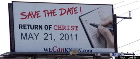
Believers Warn Neighbors Of Impending Doom On May 21. To be honest I'm actually looking forward the Second Coming - hope it's not May 21, but who really knows? If I had to give odds I'd say there's an overwhelming probability this will NOT happen, but just in case, here's an article from Huffington Post and the Religious News Service: "(RNS) Give these billboards credit: They don't hedge their bet. Judgment Day is coming May 21, 2011 -- not sometime this decade, not sometime this year, but precisely on May 21. The hundreds of billboards warning unrepentant commuters of their impending doom are courtesy of a California radio station led by 89-year-old Harold Camping, who initially predicted the world would end in 1994. In New Jersey, about 30 believers paid to erect the signs in hopes of warning and saving their neighbors, said Bob James, a Morristown electrical engineer who organized the grassroots effort. "Seven billion people are facing their death! What else could I do?" said James, who views the billboards as a message of hope. "When you have this information, with my love for my fellow man, I wanted to tell people."

Paul's Conservation Minnesota Outlook for the Twin Cities and all of Minnesota:
TODAY: A few morning showers of rain or wet snow (a little slush on some lawns?) Peeks of PM sun. Winds: NW 10-20. High: 54
THURSDAY NIGHT: Partial clearing, still chilly. Low: 40
FRIDAY: Lukewarm sun much of the day (feels like spring again!) , late night showers possible, especially western MN. High: 68
SATURDAY: Morning showers and T-showers, drier PM hours (the sun may peek through by evening). Winds: NW 10-20. Low: 52. High: 59
SUNDAY: Sun returns, nicer day of weekend. Clouds increase late PM. Low: 38. High: near 60
MONDAY: Intervals of sun, probably dry. Low: 40. High: 62
TUESDAY: More sun, feels like spring! Low: 43. High: 67
WEDNESDAY: Unsettled, a few showers, T-storm possible. Low: 50. high: 68

A Spring To Remember
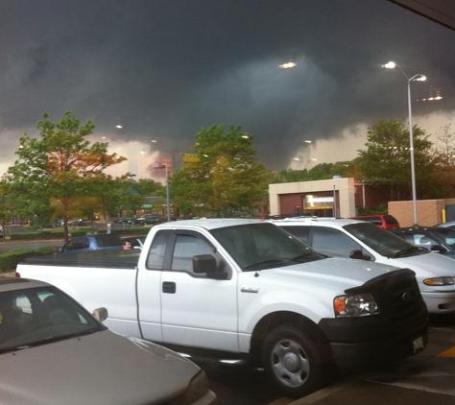
Or forget? I'm hoping for a raging case of meteorological amnesia. The first 80 and all this will be forgotten, right? "Paul Douglas. We demand you shoot your secret lasers into the sky and alter the current weather pattern we are in!" That was one of many e-mail messages in recent days. I'm just the messenger (in the Weather Witness Protection Program).
Some of us are waking up to a coating of slush on lawns and fields, but skies brighten this afternoon, temperatures recovering into the 50s.
An extraordinary tornado outbreak has pounded the south in recent days, historic in scope, all the details on my weather blog (along with some incredible videos). Believe it or not we're still getting the better end of these storms.
A few windblown showers or rain & snow taper this morning, the sun returns tomorrow with 60s. One day of Real Spring before an eastbound cool front ignites a few showers (and thunder-claps?) Friday night into Saturday morning. Skies clear Sunday, winds ease with afternoon highs near 60. More 60s are on tap next week. Yes, my strategy is working!
Excuse me; I have to excuse myself so I can go shoot more secret lasers. One of these days it may even work.
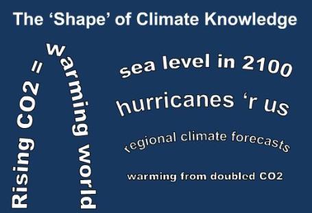
The Many Shapes Of Climate Knowledge. The New York Time's Dot Earth reporter Andrew Revkin has an interesting post on where things stand in the (constantly changing, ever-controverial) world of climate science: "Confusion and division over “global warming” often grows out of the meaninglessness of the phrase on its own. The result is that people with very different world views, in essence, create their own definitions of the term. (This is a point long made by Mike Hulme of the University of East Anglia, and is a central theme in his book, “Why We Disagree About Climate Change.”) When you get more specific, you can see that the level of confidence and range of views* on each aspect of greenhouse-driven climate change, from the basic physics onward, has a different “shape,” as I’ve tried to depict above:
- More CO2 = warming world? Clearcut.
- How much warming? Durably uncertain.
- Extent of sea-level rise by 2100? Higher, but the worst case is durably uncertain — with the latest projections about what scientists were foreseeing in 1988.
- Hurricane patterns? Less clear than a decade ago."

The Big Thirst: Why Climate Change May Cut Your Shower Short. Here's an excerpt of an article at Fast Company: "Fact: Over the last 25 years, rainfall in the western Australia city of Perth fell 20%. The flow of water into Perth’s reservoirs fell 75%. And Perth--a beautiful city, with much of the casual, creative attitude of San Francisco--became the developed-world city that came closest to simply running out of water. In places that are experiencing climate change, there’s no debate about whether it’s “real” or not, like the debate we seem to enjoy having here in the U.S. Where climate change is happening every day, its consequences are obvious, devastating--and often costly."

Porsche Hybrids, Then And Now. Check out the 1900 Porsche Hybrid, parked next to a brand new Panamera S Hybrid. More details from Wired Magazine: "Porsche rolled into the New York Auto Show with Semper Vivus, a meticulous $750,000 reproduction of the series hybrid Ferdinand Porsche built in 1900. The car provided a nice contrast to the $95,000 Panamera S Hybrid making its North American debut at the show. Semper Vivus, Latin for “always alive,” works a lot like the Chevrolet Volt. Batteries provide juice to the hub-mounted motors, and a pair of tiny single-cylinder engines step in to drive two 2.5-kilowatt generators that keep electricity flowing when the batteries go kaput. The specs are impressive, even by today’s standards. The batteries have a range of 40 kilometers (25 miles). Once the 3.5-horsepower engines fire up, Semper Vivus can go another 160 kilometers (100 miles). Top speed is 35 mph, quite quick for its day. One cool bit: the tires were chiseled from solid blocks of rubber, the only way to support the weight of the car. Semper Vivus weighs 3,700 pounds."
No comments:
Post a Comment