TODAY: Light showers thru midday. Clouds linger much of the day (some brightening possible by afternoon). Winds: NW 10-15. High: 51
SATURDAY NIGHT: Clouds give way to partial clearing. Low: 40
EASTER SUNDAY: Plenty of sun - feels like spring! High: 61
MONDAY: Sunny start, clouds increase PM. Showers Monday evening/night. Low: 43. High: 62
TUESDAY: Chance of showers, possible thunder. Low: 45. High: 59
WEDNESDAY: A drier day. Intervals of sun, a quiet spell. Low: 42. High: near 60
THURSDAY: Mix of clouds and sun, "springy". Low: 44. High: 65
FRIDAY: Mild breeze, late-day thunder? Low: 48. High: 67

A Cautionary Tale. Last night's tornado touchdown at Lambert Field in St. Louis sent shudders up my spine. I've always been worried about a large, violent tornado hitting a major airport terminal, which (when you think about it), is one of the WORST places to ride out a tornado. Why? Glass everywhere (potential projectiles on either side of you), no easy access to an underground shelter, no way to hear the emergency sirens or televised tornado warnings. What can you do?
1). Sign up for warnings on your cell phone. Don't depend on anyone else to get the information you need to stay safe.
2). Situational Awareness. If a tornado watch is in effect keep an eye on the sky, scope out the situation, and keep asking yourself, "where would you go if a tornado approached right now?"
3). Makeshift Shelter. If threatening weather approaches, and you can't get to a lower level basement in time, seek shelter in a rest room. As crazy as that sounds it will protect you from flying glass. Crouch down in a bathroom stall. Not a perfect solution, but it may save your life.
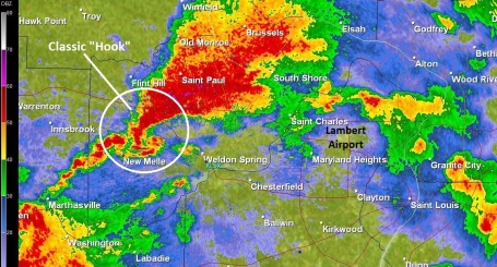
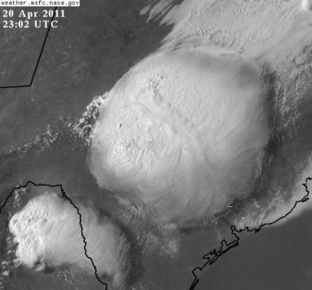
"Supercell." Here is the tornadic, rotating supercell (sometimes called mesocyclones) that ripped into Lambert International Airport outside St. Louis Friday evening. On conventional Doppler (reflectivity) displays - which measure the location of raindrops and hailstones, the swirling T-storms that often spark tornadoes look like a hook, or the number "6".
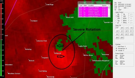
Doppler Velocity Field From STL. Here is the velocity field of the supercell seen above, the bright red smudge showing air moving rapidly TOWARD the radar site, the green-shaded region showing high-velocity air moving AWAY from the site. It's logical to infer violent rotation where those 2 fields meet. Again, it's rare to see the actual tornado itself on Doppler. The best we can do is see whether the parent thunderhead is rotating, and how rapidly. Tornadic T-storms often display more than 100 mph of "shear", 50 mph away + 50 mph toward. The Wadena tornado last June produced 130 mph of shear as I recall.
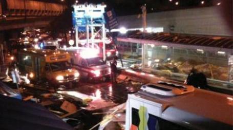
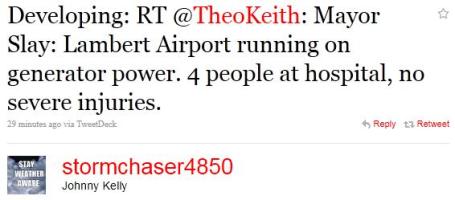
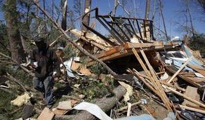
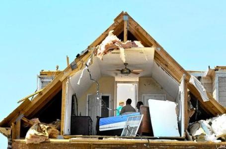
Tornado Causes Injuries At Lambert Airport. An update from KMOV-TV in St. Louis: "Several people at Lambert Airport in St. Louis were injured Friday after an apparent tornado touched down, spewing debris over the airfield, bursting glass int he concourse and damaging cars atop a parking garage.The tornado was part of a series of strong storms that struck central and eastern Missouri. Unconfirmed tornadoes were reported in several counties in the St. Louis area. Lambert spokesman Jeff Lea said he did not immediately have information about how many people were hurt, or how badly. He said the injuries were believed to be from glass that shattered as the storm hit the airport. An Air National Guard facility at the airport was reportedly damaged."

FAA: Due to TORNADO DAMAGE, the Lambert-St Louis International Airport (STL) was closed as of Apr 22 at 08:54 PM CDT. The date/time when the airport is expected to reopen is not known.
St. Louis Arch: "It moves up to 1" in a 20 mph wind and can sway up to 18" if winds hit 150 mph.
OH MAN RT @LakishaJackson: PHOTO2: Storm damage at Lambert Airport #kmov #stlnews http://twitpic.com/4o8gr9
RT @LakishaJackson: PHOTO1: Storm damage at Lambert Airport #kmov #stlnews http://twitpic.com/4o8glm
Many people cut by shattering glass at Lambert-St. Louis airport, which is closed by apparent tornado http://bit.ly/gcILbJ
In Maryland Heights, Mo., structural damage reported for as many as 50 homes, roofs torn off
RT @TWCBreaking: From Jennifer Feldman at KSDK...view inside Lambert Airport in St. Louis: http://twitpic.com/4o8qha
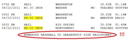
Danger Will Robinson! There are consistent precursors to tornadoes: the greenish, evil-looking sky that often precedes a particularly severe thunderstorm. Personally I start to get nervous when large hail falls, anything larger than golfball-size. Why? Any thunderstorm with an updraft strong enough to keep large hail in the air may be violent enough to spin up a tornado. Again, a tornado is the visible manifestation of a particularly extreme updraft, pulled to the ground by a bouyant surge of warmer, drier air called the RFD, the "rear flank downdraft". The tornado that hit St. Louis was preceded by baseball to grapefruit size hail, that's 4-6" in diameter?
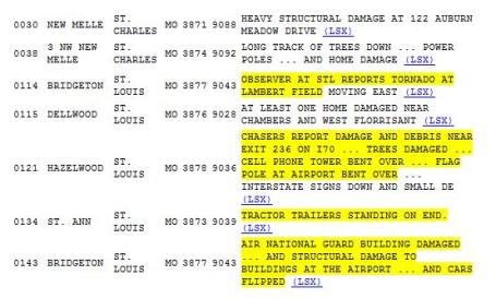
Damage Reports. More raw data from the St. Louis office of the National Weather Service.

Nothing To Sneeze At. Seeley also has some great resources for allergy sufferers: "As spring progresses many citizens begin to suffer from allergies. There are many online resources to examine air quality and pollen forecasts. Some of those that might be useful include:"
http://www.pollen.com/allergy-weather-forecast.asp
http://home.comcast.net/~halethorpe_weather/wx15.html
http://aqi.pca.state.mn.us/
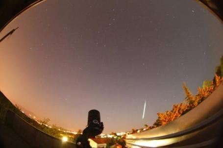
Credit: This photo was taken by; GREGOR SRDOC, Astronomical society Vidulini. Location; Sorsoni near Rijeka (Croatia). Data; 21.4.2011 00:50:56 local time. (GMT 20.04.2011. 23:50:56) EOS400D, fisheye 8mm peleng f/3.5, exp 30s, ISO1600.
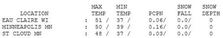
A Runny Sky. Yes, it was a fairly foul Friday with off and on showers and sprinkles. Rainfall amounts ranged from .03" at St. Cloud to .16" at MSP, .31" at Redwood Falls. Temperatures were more than 10 degrees cooler than average with highs within a couple degrees of 50.

A "Winnipeg Spring"
I know, this is getting old. The Reluctant Spring of '11 limps on; the same La Nina pattern that unleashed 86.6" of snow on the Twin Cities is keeping the northern tier states cooler than average. Meanwhile the south is heating up (triple-digit heat in Texas fanning record brush-fires), resulting in a sharp north-south temperature contrast across the USA. Throw in 100-150 mph. jet stream winds and you have a ripe environment for severe storms, flooding rains and tornadoes.
April temperatures are running 1.4 F. warmer than average in the metro area. Nighttime lows have trended milder, but daytime highs have been stunted; it feels more like mid March out there. Since March 1 MSP has seen only 6 days above 60. Last year at this time we had already enjoyed 23 days above 60 F. A strange spring indeed. "Wrap-around" showers and sprinkles linger through midday, though skies may brighten this afternoon. Easter Sunday looks much better with a rerun of sunshine and highs near 60.
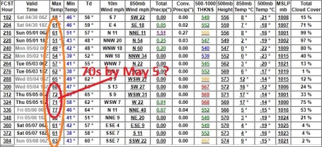
Models are hinting at some 70s the first week of May, a family of storms passing just south/east of Minnesota next week. Time to retire the winter wardrobe and take off the snow tires? I think so. I hope so.
Global Warming Doesn't Mean The End of Winter. No kidding. USA Today has the story: "Here's some good global warming news -- for folks who likes snowball fights and shoveling out their driveway -- we still have some chilly winters ahead, despite climate change. A 2008 series of National Academies of Sciences reports concluded average global atmospheric temperatures will likely rise from 2 to 11 degrees by the the end of this century, continuing a 1.4 degree rise over the previous one. Largely driven by greenhouse gas emissions from burning fossil fuels, the temperature increase's effects are expected to vary across regions, with the poles showing the biggest jumps. So what does that average increase mean for cold winters? Although fewer, there will still be some colder-than-normal ones, says a forthcoming Geophysical Research Letters report headed by computer scientist Auroop Ganguly of Oak Ridge (Tenn.) National Laboratory."
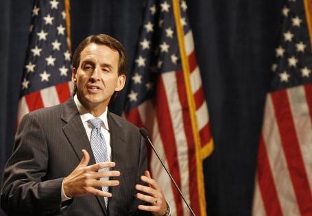
Will Steger Laments The Global Warming Change Of Heart Of Tim Pawlenty. Minnpost.com has the story: "Polar explorer Will Steger tells Mother Jones that he's baffled by the way former Minnesota Gov. Tim Pawlenty has changed his tune on global warming. Steger had worked with Pawlenty on programs to fight climate change, but that ended in 2008, when Pawlenty began his run for president and came out against efforts to fight climate change. Earlier this month, Pawlenty said human efforts are only a minor contributor to global warming. Steger told Mother Jones that Pawlenty's new stance is unfortunate: "I'm baffled by that. But I think he's getting information from the wrong source and it's really too bad for our children. It's reckless." Steger, who achieved great fame with his dog sled journeys to the North Pole and Antarctica, has long been pushing for more awareness of global warming. He's appeared at schools, churches and business meetings, often bringing along his sled dogs to grab attention. He met first with Pawlenty in 2006: "It was a real heart to heart. I really believed that morally we were on the same level. We saw the moral imperative. And he understood, and back then, he chose to veer in another direction [from his party], which took a lot of guts. I have to respect that."
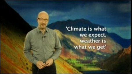
"Over the years many of you have asked me to distinguish between the words "weather" and "climate?" Here are some possible answers. I always describe weather as the environmental conditions that exist right now and climate as the historical average for the date. As climate (averages) changes over time, the probability for specific types of weather changes as well. But there are many other, more clever distinctions made through analogies by colleagues in the American Association of State Climatologists, including:
climate trains the boxer, weather throws the punches
climate is like your baseball batting average, weather is your current time at bat
climate tells you what clothes to buy, weather tells you what clothes to wear
climate is what you expect, weather is what you get
climate is the Dow Jones Average, weather is an individual stock
climate is my personality, weather is my mood today
climate is the tide, weather is the individual wave
climate is the traffic, weather is an individual car"

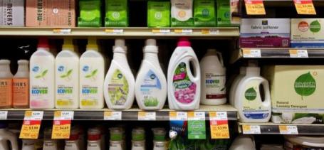
As Consumers Cut Spending "Green Products" Lose Allure. The New York Times has the story: "When Clorox introduced Green Works, its environment-friendly cleaning line, in 2008, it secured an endorsement from the Sierra Club, a nationwide introduction at Wal-Mart, and it vowed that the products would “move natural cleaning into the mainstream.” Sales that year topped $100 million, and several other major consumer products companies came out with their own “green” cleaning supplies. But America’s eco-consciousness, it turns out, is fickle. As recession gripped the country, the consumer’s love affair with green products, from recycled toilet paper to organic foods to hybrid cars, faded like a bad infatuation. While farmers’ markets and Prius sales are humming along now, household product makers like Clorox just can’t seem to persuade mainstream customers to buy green again."
No comments:
Post a Comment