* a partly sunny sky is likely much of today, enough blue sky for highs near 70. An isolated shower can't be ruled out, especially over northern/western Minnesota.
* 72 F. in the Twin Cities Saturday. That makes two days in a row above 70 at MSP. That hasn't happened since September 26-27, about 7 1/2 months ago.
* slight severe storm risk over far southwestern Minnesota later today.
* 80s possible by Tuesday as a warm front surges north, warmest of the year so far.
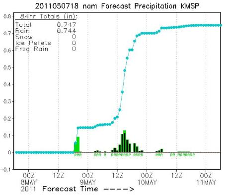
* .66" rain predicted by Wednesday morning in the Twin Cities (NAM model).
* stalled storm in the upper atmosphere keeps showers in the area Thursday through the weekend.
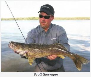
Opener Fever. Less than 6 days and counting. Hundreds of thousands of anglers are checking their rigs, lures, stocking up their trusty tackle boxes, preparing for the Big Moment: midnight Friday night. This year the Governor's Fishing Opener is up at Grand Rapids, more details here: "Explore Minnesota Tourism announced that the 63rd Minnesota Governor’s Fishing Opener has been awarded to the Grand Rapids area. The annual event, which promotes fishing and tourism in Minnesota, will be held May 13-14, 2011. Next year’s Fishing Opener will be based at Ruttger’s Sugar Lake Lodge, with fishing on Pokegama and other area lakes. Grand Rapids last hosted the Governor’s Fishing Opener in 1999....The Governor’s Fishing Opener has been a tradition in Minnesota since 1948. The event was designed to promote the development of Minnesota’s recreation industry, and in recent years, it has served as a kick-off celebration for the summer tourism season."
Fishing Opener Forecast. A couple days ago the models were hinting at sunshine, but that outlook has fizzled - it now appears a stubborn storm in the upper atmosphere will linger overhead, keeping skies gray and showery, with a healthy "walleye chop" - north winds from 10-20 mph.
Saturday Outlook for Minnesota's Northern Lakes:
Skies: partly to mostly cloudy. The sun may peek through (briefly), but a very unstable sky means that clouds will prevail.
Rain: a few light showers - not a steady rain, but possibly a few hours of showers and sprinkles.
Winds: north at 10-15, 1-2 foot waves on area lakes. Pack the Dramamine.
Temperatures: sunrise temperatures on Mille Lacs, Gull, the Whitefish chain and Leech will probably be in the 42-46 F. range, worthy of jackets. By mid afternoon temperatures recover into the mid and upper 50s, maybe low 60s on Lake Minnetonka and White Bear Lake, closer to the metro area. It may look and feel more like early October out there.
Barometer: steady or slowly rising. A rapidly falling barometer would be ideal for catching that record lunker, but I suspect barometric pressure will be steady most of the day. All in all potentially good conditions for catching your limit on Saturday.
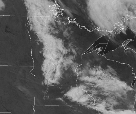
Definition Of "Partly Sunny With Spotty Showers." O.K. It DID rain on Saturday, just not in the Twin Cities. A band of showers did creep across central and northern Minnesota, leaking a little light rain on St. Cloud, Long Prairie and the Brainerd Lakes area - but this patch of convection drifted well north/west of the Twin Cities. Yep, it turned out nicer than predicted, which is better than the alternative - it does point out the vexing complications with trying to pin down hit-or-miss showers. Yesterday about 10-15% of the area picked up a little rain, the definition of "isolated showers."
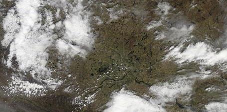
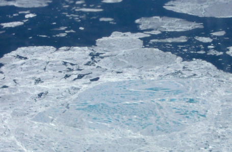
Ready For Your (Satellite) Close-Up. The 250 meter NASA "Terra" satellite snapped this photo midday Saturday, orbiting about 220 miles above Minnesota. The images have startling clarity. Click here to see the high-res photos for yourself - you can quickly pick out Lake Minnetonka and Lake Waconia, along with the Minnesota and Mississippi Rivers. The thicker clouds to the left of the screen where producing light showers and sprinkles, but drifted well north of MSP.
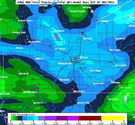
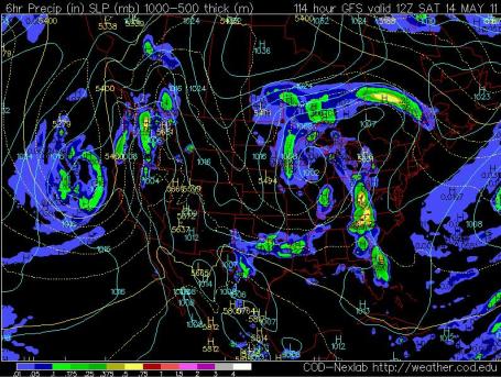
Extra-Soggy Sunday Night. The NAM model is hinting at some .5 to 1" rainfall amounts around the metro area, and much of central Minnesota tonight into Monday, more than 1.5" predicted just north of St. Cloud. A warm frontal boundary will linger close to home, keeping us showery - with a few embedded T-storms - into at least Wednesday.
A Few Waves of Showers (and T-storms). The latest NAM model hints at one wave of showers Sunday night, another (heavier) surge of rain, and possibly some heavy thunderstorm activity, during the day Monday as a vigorous warm frontal passage reaches MSP. Rainfall "meteogram" courtesy of NCEP and coolwx.com.
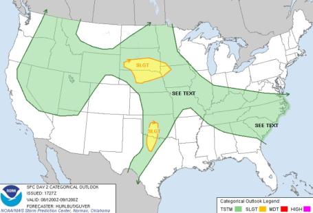
Slight Severe Risk. According to SPC, a few isolated thunderstorms may reach severe limits (winds < 58 mph and/or 1"+ diameter hail, roughly quarter-size) for parts of South Dakota, Nebraska, northwestern Iowa and southwestern Minnesota into Monday morning.
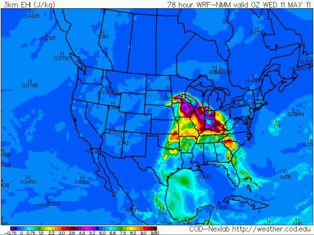
Ripe For Severe? The EHI, or "Energy Helicity Index" is a measure of instability and wind shear, two ingredients necessary for severe thunderstorms. By Tuesday evening around 7 pm values are forecast to be very high from southern Minnesota into Iowa and southwestern Wisconsin. It's hard to pin down exactly when/where severe storms may bubble up, but conditions will be ripe from Monday into Wednesday.
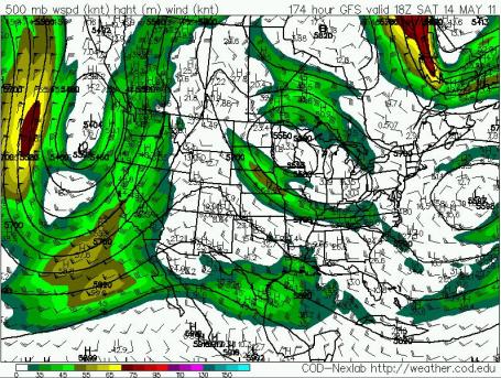
"Stacked Storm." As storms age they often stall, sometimes they even wobble (or retrograde) to the west. They're often called "cut-off" lows, cut off from the main belt of westerly jet stream winds. This scenario may play out late in the week, a swirling whirlpool of cold air aloft forecast to keep clouds (and showers) over much of the Upper Midwest from Thursday into Saturday, possibly Sunday. Right now I'm not optimistic about salvaging nice weather next weekend. Confidence levels are low: the forecast could still change (for the better) in the coming days.
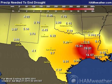
Historic Drought. The extremes are nothing short of staggering. While the greatest flood since 1927 unfolds on the Mississippi River, the worst drought in nearly a century continues across the southern Plains states. Hardest hit: eastern Texas and western Louisiana, where 20" of rain would have to fall for the drought to ease. Graphic courtesy of Ham Weather, a division of WeatherNation.
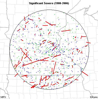
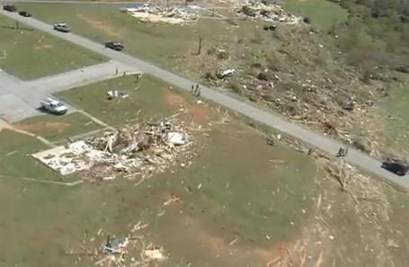
Significant Severe Weather Events in Minnesota. The Storm Prediction Center (SPC) has archived information about hail, high winds and tornado tracks in Minnesota. Blue dots represent high winds, green dots denote severe hail, the red dots (and lines) are tornado touchdowns and tracks. More details: "Significant severe weather reports during the period are plotted. Only tornadoes F2 or stronger, wind gusts of 65 knots or stronger, and hail of 2" diameter or larger are plotted."

Severe Stats. Minnesota experiences an average of 14 days/year with tornadoes, 32 days/year with damaging winds and 33 days/year with large, damaging hail. Source: SPC.
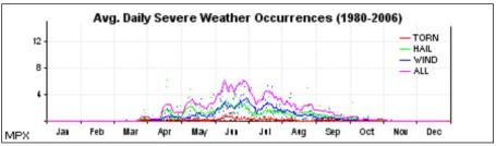
Prime Time. This bell curve shows when severe storms are most likely in the Twin Cities and all of MInnesota, peaking in June. In theory severe storm season runs from mid March through late October, but severe storms are mostly likely from May through July. Source: SPC.
Global Weather Extremes. Jeff Masters and his information-packed Wunderblog have a good overview of April extremes, including last week's record tornado outbreak, and news of unusually warm weather across Europe: "April was the warmest such on record for many parts of Western Europe including London where the temperature averaged 4.0°C (7.2°F) above normal and peaked at 27.2°C (81.0°F) on April 23rd. A reading of 27.8°C (82.0°F) at Wisley was the 2nd warmest April temperature ever measured in the British Isles (the record remains 29.4°C/84.9°F at Camden Square, London on April 16, 1949). It as also the warmest April on record nationwide for the United Kingdom with a departure from normal of +3.7°C (+6.7°F). The warmest April temperature ever measured in all of Europe occurred at Orihuela, Spain on April 9th with a 39.0°C (102.2°F) reading. Other national April records included readings of 33.9°C (93.0°F) in France and 32.0°C (89.6°F) in Switzerland. In Switzerland wildfires broke out in several locations burning thousands of acres of forest. Drought has reached critical levels in both Switzerland and the Low Countries, especially Holland where outdoor burning and smoking have been banned. In the United Kingdom the March-April period has been the 4th driest on record since 1766 (the driest such period was in 1938)."

Simple Straps Help Homes Weather Storms. This may be a good option for many homes in tornado and hurricane alley, a relatively cost-effective way to reinforce a home, as reported by KCCI-TV in Des Moines: "Eric Hanson shows you how some simple changes can help a home in severe weather."
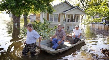
Residents Brace For More Flooding As Mississippi River Swells. CNN has the story:
"As the Mississippi River gushes downstream with no clear boundaries, flooding continues to deluge parts of Tennessee as residents farther south brace for what will come. "When you see the Mississippi River and it's about two miles wide because it's lost its borders, it's sobering," said Tennessee Gov. Bill Haslam. In some areas, murky brown water inundated entire neighborhoods, with only the roofs of buildings and treetops visible from the sky. The Mississippi River is expected to crest about 14 feet above flood stage at Memphis on Wednesday. Authorities are planning as if the river will exceed that forecast, said Bob Nations, director of the Shelby County Office of Preparedness. "This is an act of nature, and nature plays funny tricks sometimes," he said. Amid the calamity, some positive news surfaced. The U.S. Coast Guard re-opened a portion of the river near Caruthersville, Missouri, to limited commercial traffic late Friday. "The Coast Guard will continue to work with the Army Corps of Engineers, waterway users and local communities to monitor river levels and restrict river traffic when necessary to protect the public," said Coast Guard Capt. Michael Gardiner. This limited re-opening was allowed for by a projected drop in the river crest from 49.5 feet to 48.1 feet, he said. The drop means one vessel can pass through the security zone at a time, Gardiner added."
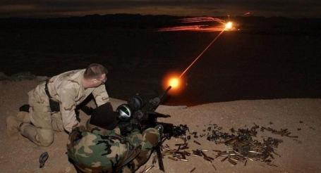
Here's Even More Proof That Navy Seals Are Incredible Supermen. What IS that Seal shooting? Some sort of new ray gun or laser? Is that just tracer fire? Sam Biddle from Gizmodo is duly impressed: "If the perfectly executed killing of Osama bin Laden didn't convince you that SEALs are walking nuclear bombs with bear claws and the tail of a velociraptor, consider the above photo. We don't know what the hell kind of bullety beam of death he was shooting (anyone know?), or what the advanced night targeting system he's using was, but—just, come on, look at that. [via Slate]"

The Navy Seal's Booty Was (Sunday's) Biggest Victory. Getting Bin Laden may have just been the icing on the cake - the quanity and quality of the intelligence gathered during the raid may be an even bigger story, according to Gizmodo: "The most important achievement of yesterday's operation wasn't killing Osama. It was the US Navy SEALs' booty: dozens of computers, memory sticks and disks loaded with information that might just crush all of al Qaeda's network. After shouting "Geronimo!" to their commander over radio—the signal that indicated the death of bin Laden from a shot above his eye—the SEALs grabbed all the electronic material they could find in the compound and ran with it and Osama's body to their custom MH-60 Black Hawk helicopters. With their weapons still hot, the commando handed the electronic material to a special team of CIA and military intelligence operatives. According to a US official speaking to Politico, hundreds are going through the data in a secret location in Afghanistan: They cleaned it out. Can you imagine what's on Osama bin Laden's hard drive? It's going to be great even if only 10 per cent of it is actionable. Decrypting "the mother lode of intelligence: Indeed, given the amount of material recovered, his enthusiam seems more than justified. We can only speculate about the state of the data, but even if some of the equipment was damaged during the attack, it appears that most of it is intact."

The Holy Grail Of (Pocket-Worthy) Digital Cameras? True confession time: I have a "problem" with digital cameras. I have a considerable collection of SLR's, but my quest, my mission, is to track down the "perfect camera" that can be stored in a pants pocket, available anytime, anywhere. I subscribe to the theory that the best camera is the one you have with you (at all times). The iPhone 4 camera is OK, good enough for many occasions, but you're not going to get great images from a smartphone. Maybe 1-2 years from now. And I defer to SLR owners (those of you with big, hulking Nikons and Canons - no need to send me flame-mail). I know your camera is better, but get back to me in a few years when you're a hunchback from lugging along the camera bodies and glass. I love my Nikon D3S, but it's a pain to carry - literally! I have a Nikon AF-S Nikkor 24-70 mm lens that takes incredible shots, but the thing must weigh 10 pounds. And I can't get it in my pocket (without attracting a lot of unwanted stares). So my quest remains: find me a digital camera that takes HD video (1080p), with a good zoom lens, panorama mode, RAW capability, preferably a camera that can snap off shots WHILE you're in video mode. Throw in 3-D (just in case I someday want to see my Mother In Law from every perspective). Surprise me. Well, after much experimenting (I've tried the Sony a55, the Nikon Coolpix P7000, the Sony Cyber-Shot series, and more examples I'm too embarrassed to list - I think I've found a winner. At least for the next couple of weeks. Drumroll please: it's the Olympus SZ 30-MR. It's a remarkable camera, and I'm totally smitten. There is a "watercolor" mode, a "beauty" mode, that automatically removes the blemishes and imperfections on your perfect spouse's face. It takes still photos WHILE you're shooting video. Too many goodies to list. If you're a photo-buff it's worth checking out, an awful lot of horsepower for roughly $400. Five stars. More details from Olympus (and no, I don't get a spiff or commission - fat chance)."
Here are 3 different versions of the same pic I took yesterday: regular mode, "watercolor", and "sketch", all created with the remarkable Olympus SZ-30MR:


"Olympus Imaging America Inc. today unveils the full-featured SZ-30MR, a super-zoom camera with a multi-recording function capable of simultaneously capturing 1080p HD video and 16-megapixel still images without missing a frame, perfect for documenting events like birthdays and school plays. The Olympus SZ-30MR helps you capture it all with its 24x optical wide-zoom lens, and displays your pictures and videos on its crisp 3.0-inch, high-resolution LCD. Whether you’re trying to capture the action on the local soccer field or that once-in-a-lifetime wildlife shot, this is the camera for you. The Olympus SZ-30MR comes packed with a variety of features that deliver a superior imaging experience far and wide:
- New! Multi-Recording Mode – a world-first, Olympus Dual Engine technology enables users to combine various photo and movie recording modes simultaneously;
- 24x wide-optical zoom – enables exceptional close-ups;
- Full HD Video and HDMI® Control – delivers a broadcast-quality 1080p movie experience when played back on an HDTV;
- New! 9fps Continuous Shooting (16MP) – offers a full-resolution burst mode enabling continuous shooting, in rapid succession;
- New! 3D Photo Mode – captures two shots of a scene from two different angles to create still photos that can be viewed with the added excitement and realism of 3D; and
- New! Eye-Fi™ Card Compatibility – enables automatic wireless uploading of images to the website or PC of your choice.
Dpreview.com (arguably the best site on the web for camera reviews, advice and tips) has a thorough review of the Olympus SZ-30MR here.
O.K. Thanks for allowing me to geek-out. It's a slow weather day. Looking for an excuse for a new digital camera? Try this one (which usually works with my patient wife of 27 years: "you can't put a price tag on family memories").
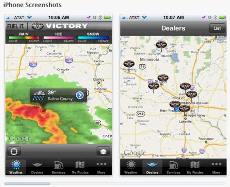
"Victory Rides." Polaris makes an awesome motorcycle, the "Victory" line. Full disclosure: WeatherNation is creating (free) apps for iTunes and Android. We created a snowmobiling app called "Snow Trails", and now there's an app focusing on weather for motorcycle riders. Although you don't have to have a Victory motorcycle to download and appreciate this app, which works on iPads as well as iPhones (and Android smartphones). In addition to tracking weather (radar, satellite, temperatures, wind speeds) you can see the nearest services to your GPS location, restaurants, gas stations and hotels, find your closest friendly Victory dealer, even track and save your favorite ride. Best of all, the price is right: free. More information on Victory Rides from Apple here: "Created by the devoted motorcycle enthusiasts at Victory Motorcycles, Victory Rides is a must-have app for the true American biker. With this app, everything you need for adventures on the open road is only the touch of your finger away."
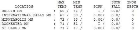

Phenomenal Saturday. Yes, it was nicer than advertised, better than predicted. The showers stayed (well) north, leaving us with enough sun for low 70s in the metro area. Highs ranged from 46 at Grand Marais (where spring is nowhere in sight), to 71 in St. Cloud and 72 in the Twin Cities. Redwood Falls picked up .09" rain, a trace of showres at Duluth and Rochester.

Paul's Conservation Minnesota Outlook for the Twin Cities and all of Minnesota:
TODAY: Dry start, sun gives way to increasing clouds, a few PM showers. WInds: SE 10-20. High: 68
SUNDAY NIGHT: Showers likely, even a few heavy T-storms possible. Low: 55
MONDAY: Humid, few strong/severe T-storms? (Best chance of a few severe storms over southwestern MN). High: 66
TUESDAY: Taste of summer, almost hot with periods of sunshine. Sticky. Low: 62. High: 82 (unusually warm, dry air aloft will probably "cap" the atmosphere close to MSP, preventing strong/severe T-storms close to home).
WEDNESDAY: Passing T-shower, turning breezy and cooler. Low: 59. High: near 70
THURSDAY: AM sun, PM clouds, showers Low: 47. High: 60
FRIDAY: Storm aloft stalls nearby, more showers (best chance PM hours). Low: 45. High: 59
SATURDAY: Cool Fishing Opener. Partly to mostly cloudy with a passing shower or sprinkle. Light jackets recommended. Winds: north/northeast 10-15. Low: 45. High: 62

Better Than Expected
"All weather, like politics, is local." Predicting spring showers is an exercise in futility. We can tell when conditions are ripe (instability, sufficient low level moisture, a "trigger" to set off convection: showers & T-showers).
"Paul, you predicted spotty showers. It didn't rain at MY house. You're wrong. How does that make you feel?" Sorry. But Saturday showers did clip St. Cloud and Brainerd, drifting well north of the metro, to everyone's delight.
Winter storms produce steady, widespread precipitation. But as we transition into a more summer-like pattern rainfall patterns become "convective", hit-or-miss. One town sees a downpour, while 10 miles down the road the sun is out & people are grilling in their yards. The weather equivalent of predicting a hiccup.
Disclaimers aside, most of us dodged a soggy bullet Saturday. A promising start to Mother's Day gives way to a growing chance of showers this afternoon. The approach of a vigorous warm front ignites a few strong T-storms into Monday; a severe risk over southwestern MN.
Looks like a soggy week; 80 Tuesday - then cooling off. A stalled storm aloft sparks clouds, showers (and jackets) for the Fishing Opener.
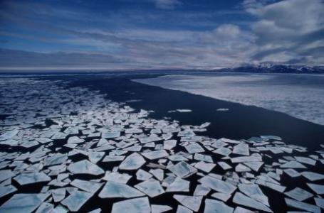
Climate Change Effects In Arctic More Extensive Than Expected. U.S. News and World Report has a summary: "Together with Terry Callaghan, a researcher at the Royal Swedish Academy of Sciences, Margareta is the editor of the two chapters on snow and permafrost. "The changes we see are dramatic. And they are not coincidental. The trends are unequivocal and deviate from the norm when compared with a longer term perspective", she says. The Arctic is one of the parts of the globe that is warming up fastest today. Measurements of air temperature show that the most recent five-year period has been the warmest since 1880, when monitoring began. Other data, from tree rings among other things, show that the summer temperatures over the last decades have been the highest in 2000 years. As a consequence, the snow cover in May and June has decreased by close to 20 per cent. The winter season has also become almost two weeks shorter – in just a few decades. In addition, the temperature in the permafrost has increased by between half a degree and two degrees. "There is no indication that the permafrost will not continue to thaw", says Margareta Johansson. Large quantities of carbon are stored in the permafrost."
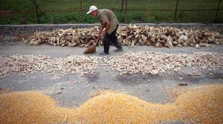
World's Farmers Feel The Effects Of A Hotter Planet. NPR has the story: "Scientists have long predicted that — eventually — temperatures and altered rainfall caused by global climate change will take a toll on four of the most important crops in the world: rice, wheat soy and corn. Now, as world grain prices hover near record highs, a new study finds that the effects are already starting to be felt. "For two crops, maize (corn) and wheat, there has actually been a decline in yields, if you account for the trend in climate — especially the warming trend that we've observed over the last 30 years," says Wolfram Schlenker, who teaches environmental economics at Columbia University. He's a co-author of the study, along with David Lobell and Justin Costa-Roberts at Stanford University. The scientists looked specifically at places where there are warming trends, and sure enough, they found these staple crops weren't doing quite as well. For rice and soy, declines in some places were offset by productivity boosts elsewhere in the world, so there was no overall change. But they did see a change for wheat and corn. The losses caused by warming thus far are still smaller than the gains made though improved agriculture. "We're not saying yields have gone down, just to make this clear," Schlenker says. "What we're saying is yields are lower than they would have been without the climate trend. So yields have still been going up over the last 30 years."
Soot Studied To Slow Global Warming. The Star Tribune has details on a worrying trend in the Arctic: black carbon, soot - which lowers albedo (darker surface), increasing warming and melting: "WASHINGTON - American scientists working on an island far above the Arctic Circle have been launching unmanned aircraft and digging snow samples to measure how soot helps melt Arctic snow and ice. Satellite observations in recent decades show longer warm seasons and more melting throughout the region. One reason for this is black carbon, the basic component of soot. The black pollution absorbs light energy, increasing temperatures that speed melting. The measurements over the past month on a Norwegian island of the Svalbard group, east of northern Greenland, could help show the most useful places to reduce soot -- one part of broader efforts to slow Arctic warming and the rise in sea level that it will bring to coastal communities worldwide. Different sources of black carbon have different chemical tracers, said Patricia Quinn, a chemist and co-leader of the team. The tracers, along with models of airflows, allow scientists to figure out where the soot came from. "So we can say this is coming from a forest fire burning in this region or oil burning in this region, indicating that those are the sources that really need to be targeted and reduced," Quinn said."

Vatican Calls For Immediate Action On Climate Change. The story from sustainablebusiness.com: "A report commissioned by the Vatican's Scientific Panel, the Pontifical Academy of Sciences doesn't mince words: it urges the world to act quickly and strongly to address climate change. It says: "humans must act decisively now to avert a coming crisis." "We have entered a new geologic epoch that began when the impacts of mankind on the planet became a major factor in environmental and climate changes." "We call on all people and nations to recognize the serious and potentially reversible impacts of global warming caused by the anthropogenic emissions of greenhouse gases and other pollutants," it says. "If we want justice and peace, we must protect the habitat that sustains us." The report says climate change is already underway and that action is necessary as a matter of social justice, especially for the poor. It ties action to the biblical idea of "stewardship" for the Earth, described here as "a planet blessed with the gift of life." It asks "all inhabitants of this planet receive their daily bread, fresh air to breathe and clean water to drink." It concludes: "The believers among us ask God to grant us this wish."
No comments:
Post a Comment