TODAY: Partly sunny, very windy. Wisconsin storms (should flare up well east of MSP). Winds: SW 20-35. High: 76
TUESDAY NIGHT: Partly cloudy, still breezy (noticeably less humid). Low: 54
WEDNESDAY: Plenty of sun, no weather-worries. High: 74
THURSDAY: Few T-storms, sticky again. Low: 59. High: 81
FRIDAY: Hot sun, storms probably stay north. Low: 70. High: near 90
SATURDAY: Plenty of sun, "lake-worthy". Low: 67. High: 83
SUNDAY: Less sun, passing T-shower? Low: 63. High: near 80
MONDAY: Warm sun, feels like summer. Low: 65. High: 85

Hottest Day of 2011. After a thundery start the sun broke through Monday afternoon and the mercury soared to 88 in the Twin Cities, 90 at Rochester - a tie for the hottest day of the year so far (tied with May 10 when the mercury reached 88 F. in the metro area). It was only the second time this year we've been in the 80s.

Memorial Day Damage Reports. Storms during the morning hours produced 1/2 to 1" diameter hail in the metro area. Monday evening winds gusted to 60 mph at Chokio, in Stevens county. Flash flood warnings were posted for Grant county, in west central Minnesota, with Doppler-indicated rainfall amounts of 2-3" in a relatively short period of time. Click here to see all the damage reports from the Chanhassen office of the National Weather Service.
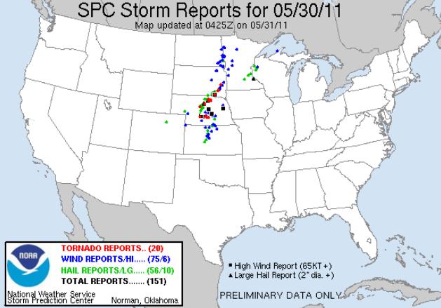
Severe Storm Reports. According to SPC, as of 11:30 Monday night 20 tornadoes had touched down from Nebraska into South Dakota. No confirmations of touchdowns in Minnesota, but there were straight-line wind damage reports over western Minnesota, large hail reports closer to the metro area.
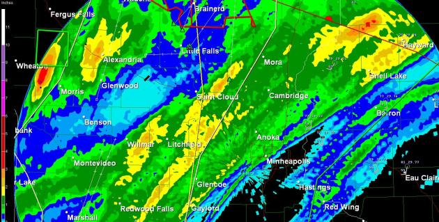
Memorial Day Rainfall Amounts. Doppler radar calculated some 1.5" rainfall amounts just north/west of the Twin Cities, bands of heavy rain from Willmar and Litchfield to St. Cloud. Some 2-4" amounts fell just east of Wheaton.
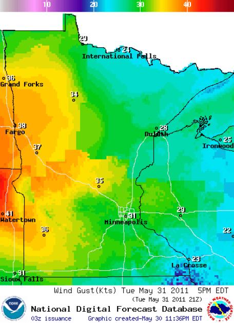
Blustery Tuesday. A cool frontal passage will whip up wind gusts in the 30-40 mph range, the strongest winds over central and western Minnesota.
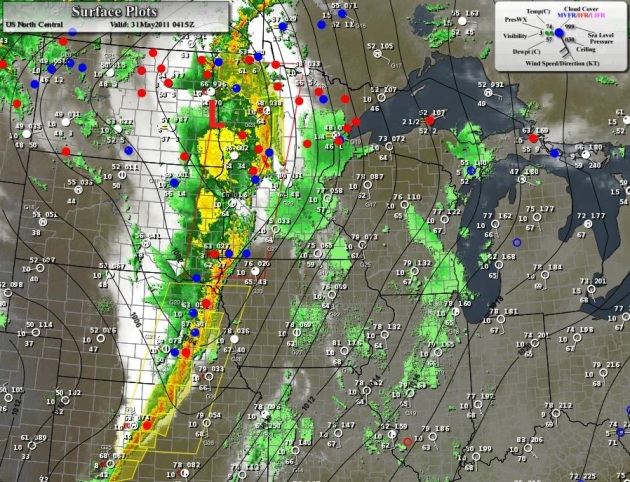
Squall Line. The weather map at 11:30 pm Monday night showed an intense area of low pressure over the Red River Valley, a cold front trailing south. The strongest storms passed north of the Twin Cities overnight, but a few lingering showers can't be ruled out early today - heavy T-storms possible over Wisconsin (but any severe threat should stay east of MSP today).
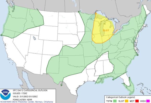
Tuesday Severe Threat. Hail, straight-line wind gusts and a few isolated tornadoes are possible from Madison and Chicago to Detroit later today, but an infusion of cooler, drier, more stable air should prevent any wild storms across Minnesota.
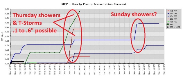
Thursday Storms. We dry out today, gusty southwest winds pumping lower humidity into Minnesota. Dry weather should prevail Friday and Saturday with a slight chance of a shower or T-shower Sunday.

Evidence Of What An EF-5 Can Do. I stumbled upon this photo from Joplin and did a double-take. I've never seen anything like this - a "spear" of wood penetrating a concrete curb. This is what 200-250 mph winds are capable of.
University of Alabama Student Caught Up In Two Tornadoes In Two Months. What are the odds of this? A student, April Fuller, survived the Tuscaloosa, Alabama tornado, only to be struck again less than a month later in Joplin. Tuscaloosanews.com has her unbelievable story: "Like most University of Alabama students, April Fuller was shaken up after the events of April 27. She vividly remembers the yellow sky and the awful sound of the EF-4 tornado as it plowed through Forest Lake, three blocks from her home on Meador Drive, decimating homes and forever changing the landscape of the town she has called home for two years. “I honestly thought that was a once in a lifetime thing,” she said. It wasn’t. On April 29, Fuller began a long drive home to Joplin, Mo., where an EF-5 tornado leveled much of the town May 22. Fuller survived, but, for the second time in three weeks, a monstrous storm passed within three blocks of her. “At first I just burst into tears because I couldn’t handle this again, especially in my home town,” Fuller said. “It was just shock. I hate saying this, but I’m probably the only person in the world to go through both of those storms and then survive.” On April 27, the tornado glanced by her home. Her upstairs neighbors took pictures of the twister as it passed, and in the aftermath Fuller and her friends retreated to another friend’s house on campus to check on friends and see if the campus had been hit. She found no damage and all her friends were fine, but the mood on campus was still solemn."

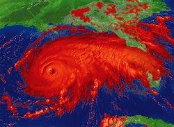
Given The Choice, I'd Prefer A Hurricane. NO question about it - I would to. You can see hurricanes coming, usually days or even weeks before they make landfall. You have time to make plans, secure your most precious belongings and move to safety. Tornadoes? In spite of all our elaborate technology there's still no way to tell which town will be struck more than 10-30 minutes ahead of time. Diane Roberts from NPR has some thoughts on the subject: "Nature's fury has also been in evident in the killer tornadoes that have swept the Midwest and the South. Now comes hurricane season, which officially begins on Wednesday. Essayist Diane Roberts has seen both kinds of storms and she'd rather deal with only one.
DIANE ROBERTS: I used to live in Tuscaloosa, Alabama. Every spring, the sirens would go off, and I'd cower in the downstairs hall of my old, old house, waiting for the roaring of the wind that signified the end of the world. I was lucky - the tornadoes always tore through somewhere else, some neighborhood across the river or a little to the south. I saw one once from my back porch. It was at least mile away, coiling, thick and dark against an ash-colored sky. To me, it looked as malevolent as a pit viper. In 2006, I came home to Florida, home to stockpiling bottled water and windows crisscrossed with masking tape, home to hurricanes. I look at the pictures of Tuscaloosa in the moments and hours after a tornado whipped through on April 27th. It is hardly recognizable. Many of my familiar places are gone. And the trees. Tuscaloosa is called the Druid City because of the old oaks that line the streets and shade everybody's yard. Now too many of them are just leaf-bare splinters. Give me a hurricane any day. They can be deadly, of course, but compared to tornadoes, hurricanes play by gentlemanly rules. They proceed at a stately pace. You have time to pack the insurance papers and put the photo albums in the car, grab the cat and the kids and drive inland. Tornadoes are not so sporting. They're born in the cloud world, angry stepchildren of the thunderstorm. Tornadoes are anarchic - you don't know where they're going. You can't outrun them. We have tornadoes in Florida sometimes, but it's hurricanes we're supposed to fear. For thousands of years, they have cut islands in half, made and remade beaches, pushed water up hills and turned forests into lakes. Yet the advent of hurricane season is a battle against willful amnesia. Too many Floridians don't remember Andrew or Ivan, much less Donna, the 1960 'cane that decimated the citrus crop, or the nameless monster that hit Okeechobee in 1928, killing 2,000 people. Maybe it's because half the state just moved here -to paradise. Who needs bottled water and evacuation route maps in paradise? We insist life is a beach, even as images of Joplin and Tuscaloosa flit like ghosts across our screens."
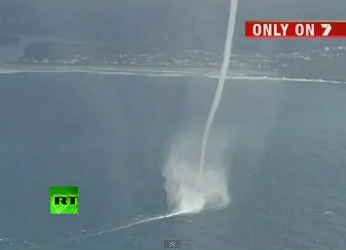
Amazing Waterspout Videotaped Off The Coast of Australia. Click here to see a remarkable waterspout YouTube clip: "Dramatic footage filmed from a helicopter by Australia's Channel 7 shows a series of powerful waterspouts near the coastal suburb of Terrigal, on Australia's New South Wales coast. Several powerful columns of swirling air could be seen blasting along the water's surface near the coastline. Channel 7 claimed the spouts reached heights of up to 600 metres (nearly two thousand feet), but dissipated as they neared land. The natural wonders came as strong winds and heavy rain also lashed other parts of the state, causing flash flooding and traffic chaos in Sydney."
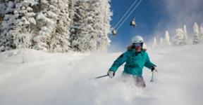
So Much Snow That Aspen Is Re-Opening. Good grief. Nothing like a little June skiing. America's weather has gone off the deep end, as reported by the Aspen Times: "ASPEN — Aspen Mountain will reopen for skiing this weekend with a better base depth of snow on Memorial Day than it had on New Year's Day. The base depth has hovered around 70 inches at the mountaintop since the Aspen Skiing Co. announced last week it will extend the skiing season. The base was 38 inches on Jan. 1. The ample amount of snow convinced the Skico to fire the chairlifts back up on Aspen Mountain for the long holiday weekend and for future weekends as long as conditions hold up. There will be 25 trails and roughly 136 acres of mostly intermediate terrain open Saturday, Sunday and Monday, May 28-30. All the open terrain will be served by the Ajax Express lift from 10 a.m. to 2 p.m. The Silver Queen Gondola will run for rides up and down the mountain. There will be no top-to-bottom skiing. Temperatures have been below freezing at night so the snowpack has been pretty well preserved since Aspen Mountain closed on April 10, Skico spokesman Jeff Hanle said. The snow gets sloppy as temperatures climb during the day, so skiers and riders should be prepared for variable conditions. “Bring some wide skis and do some water skiing,” Hanle advised."
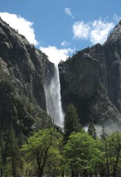
Yosemite Waterfalls Spectacular From Snow Melt. The story from azcentral.com: "YOSEMITE NATIONAL PARK, Calif. - Water, water everywhere - and it's a spectacular sight. Record Sierra snowfall over the winter now means record snow melt as temperatures rise, swelling Yosemite National Park's iconic waterfalls, streams and rivers to their most turbulent level in years. Yosemite Falls, the nation's tallest, is spewing enough water to fill a gasoline tanker truck every two seconds. The force of water at Bridalveil Falls across the valley kicks up a mist that clouds the meadow below. It means that until the peak melt around mid-June, visitors will experience more treacherous beauty in Yosemite than even the travel brochures promise. "Breathtaking, that's what it is," said Lynne Bousie of Scotland, who stopped to pose for a photograph at the spot where the paved trail to Yosemite Falls makes a turn and the first full view of its entire 2,425-foot drop comes into view. Water cascading from the many signature falls that cut across Yosemite's granite walls (as well as countless unnamed ones that spout only in peak years like this) is swelling the Merced River. For the next few months the roar of violently churning water will drown out all other background noise in the park."
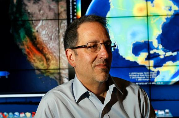
Groundwater Depletion Is Detected By Grace Satellites. The New York Times has the story of a new generation of powerful satellites (polar-orbiting, about the size of a small car) that can actually sense what is happening below the Earth's surface: "IRVINE, Calif. — Scientists have been using small variations in the Earth’s gravity to identify trouble spots around the globe where people are making unsustainable demands on groundwater, one of the planet’s main sources of fresh water. They found problems in places as disparate as North Africa, northern India, northeastern China and the Sacramento-San Joaquin Valley in California, heartland of that state’s $30 billion agricultural industry. Jay S. Famiglietti, director of the University of California’s Center for Hydrologic Modeling here, said the center’s Gravity Recovery and Climate Experiment, known as Grace, relies on the interplay of two nine-year-old twin satellites that monitor each other while orbiting the Earth, thereby producing some of the most precise data ever on the planet’s gravitational variations. The results are redefining the field of hydrology, which itself has grown more critical as climate change and population growth draw down the world’s fresh water supplies. Grace sees “all of the change in ice, all of the change in snow and water storage, all of the surface water, all of the soil moisture, all of the groundwater,” Dr. Famiglietti explained. Yet even as the data signal looming shortages, policy makers have been relatively wary of embracing the findings. California water managers, for example, have been somewhat skeptical of a recent finding by Dr. Famiglietti that from October 2003 to March 2010, aquifers under the state’s Central Valley were drawn down by 25 million acre-feet — almost enough to fill Lake Mead, the nation’s largest reservoir."

Navy Roommates Shared Their Lives, Now Lie Together At Arlington. This is the heartbreaking story in the Baltimore Sun that chronicles the lives of two roomates at USNA, both suffering tragic deaths in Afghanistan, and the decision to have them buried side by side at Arlington National Cemetery. I hope you had a chance to reflect on the true meaning of Memorial Day yesterday, giving thanks for the incredibly brave men and women who sacrificed everything for the country they loved: "That Travis Manion and Brendan Looney ended up side by side should surprise no one. Loved ones had always been struck by the similarities between the Naval Academy roommates — both family men, both rugged athletes, both warriors who yearned to reach the heart of action.Now, they needed to be together again. It was the only bit of comfort Amy Looney could fathom as she watched white-gloved soldiers carry her husband's casket from the back of an airplane at Dover Air Force Base last September. Three years earlier, a sniper had shot Travis in Iraq after he exposed himself to enemy fire so he could drag wounded comrades from an ambush. Now, Brendan was gone as well, killed in a helicopter crash in Afghanistan. Confronted with that cruel reality, Amy Looney was sure what had to happen next: Brendan, the absurdly tough Navy SEAL she had fallen for back in Annapolis, would want to spend eternity beside Travis in Arlington National Cemetery. In life, they laughed at jokes that only they were in on, blended into one another's families and talked quietly of their hunger to fight where they were needed most. Amy Looney wanted all of that to endure beyond terrible loss. "It was the only peace I could find in the whole situation," she says. When she made her thoughts known, the Manions agreed that the men belonged together, even though that meant moving their son from a Pennsylvania cemetery. Travis was reinterred at Arlington on a Friday in early October, and Brendan was buried to his left the following Monday. There they lie. Though undeniably tragic, the culmination of Travis and Brendan's bond is more than that for the people who loved them. It's a story of bravery, of goodness, of two men who died doing what they were put on the earth to do."
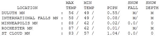

Like Turning On A Switch. Light jackets Sunday with an overcast sky and a cool east wind, and then 18 hours later shorts, t-shirts and a hot southerly wind. The mercury peaked at 83 in St. Cloud, 88 in the Twin Cities, and a steamy 90 at Rochester. Meanwhile Duluth saw a high of only 56 with a stiff wind off Superior.

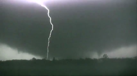
Tornado Hysteria
Of all the storms we track (and attempt to predict) nothing conjures up more fascination and dread than tornadoes. Conventional storms, floods, even hurricanes, take days to materialize; we can see them coming and evacuate, if necessary. Not so with twisters. The best we can do is tell when the atmosphere is ripe, and then only track them once they spin up on Doppler. It's an atmospheric version of a Deadly Lotto: which towns will get hit? There's no way to tell more than 10-30 minutes in advance.
You SHOULD pay attention to tornado watches. Don't change your plans, but watch the sky - and stay plugged into local media.
Out of 100 T-storms an average of 10 will be severe, only 1 will ever spin up a tornado. A greenish sky, lowering, rotating wall cloud, and large hail are all tip-offs that you may not be dealing with a generic T-storm.
The older I get the more respect I have for nature. With all our technology there's still no way to stop a tornado. All we can do is pay attention.
Expect a windy Tuesday with a sharp drop in humidity; a sunny, fine Wednesday. Thursday T-storms precede a "hot front": near 90 Friday. We cool down slightly next weekend, highs near 80. Not bad.
Weather-Weary Nation Not Surprised By Forecast Of "Blood Storms". O.K. This is a parody. But the way this year is going NOTHING would surprise me. In bad taste? Perhaps, but after the spring we've endured I thought a little levity might be in order. The Onion "reports": "WASHINGTON, DC—A National Weather Service advisory predicting that graphic blood storms will touch ground in the southern U.S. Wednesday is being met with numb resignation by weather-weary Americans. "Guess I should go buy some plastic tarps and cover up the house, or what remains of it," said Scott Huster of Waveland, MS, echoing the sentiments of a nation battered in recent months by a succession of violent hurricanes, tropical storms, and tornadoes. According to the advisory, clouds of pure blood have congealed in the atmosphere above Port-au-Prince, Haiti and are heading north at speeds of up to 80 miles per hour. NWS meteorologists predict that the unprecedented storm will splatter most of the Gulf states and West Coast by Friday. "I suppose I'll have to cancel the barbecue," said Larry Milhouse of Kiln, MS. Meteorologists are predicting an epic storm of biblical proportions, marked by bullet-velocity winds and flash blooding in low-lying areas. In the Great Lakes and New England states, blood may even coagulate and freeze into softball-sized clot-hail, shattering windows, damaging roofs, and triggering massive blockages on roads and highways. "Blood-hail can't be any worse than the early thaw in spring," Vermont mother of four Stacey Boswell said. "Still, I'd better take the clothes off the line."
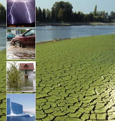
Climate Stories:
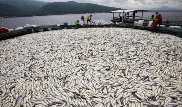
A "Sudden" Climate Change Kills Millions Of Fish In The Philippines. Another bizarre story from the International Business Times: "Hundreds of thousands of milk fish washed up dead at Taal Lake in Talisay, Batangas, south of Manila on Sunday, baffling environmentalists and raising concerns over climate change issues. "About 500 metric tons (500,000 kilos) of fish, worth more than 50 million pesos (U.S. $ 1.159 million) were seen floating in the water in the six towns of Batangas province the past two days", a local mayor told Reuters. According to a local town agriculturist, the cause of the fish kill was a "sudden" climate change in the area. The common perception of fish death is linked to depletion of oxygen in water, which is caused due to a number of factors. Gases released from volcanic activities often lead to poor oxygen levels in nearby lakes, but scientists believe that the deaths are not related to activitities inside Taal volano, which is surrounded by the Taal Lake. However, they didn't rule out the possibility of a sudden drop in temperature for the cause of the deaths of millions of fish."
Climate Change Harder To Deny. Agweek.com has the story: "WASHINGTON — “Climate change is occurring, is very likely caused by human activities, and poses significant risks for a broad range of human and natural systems.” So says the National Research Council of the National Academy of Sciences, the country’s preeminent institution chartered to provide scientific advice to lawmakers. In its report, “America’s Climate Choices,” a panel of scientific and policy experts also concludes that the risks of inaction far outweigh the risks or disadvantages of action. The most sensible and urgently needed action, the panel says, is to put a rising price on carbon emissions, by means of a tax or cap-and-trade system. Accepting change: None of this should come as a surprise. None of this is news. But it is newsworthy, sadly, because the Republican Party, and, therefore, the U.S. government, have moved so far from reality and responsibility in the approach to climate change. Seizing on inevitable points of uncertainty in something as complex as climate science and on misreported pseudo-scandals among a few scientists, Republican members of Congress, presidential candidates and other leaders pretend that the dangers of climate change are hypothetical and unproven and the causes uncertain. Not so, says the National Research Council."
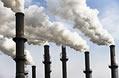
Prospect Of Limiting The Global Increase In Temperature to 2 C. Is Getting Bleaker. An ominous update from the IEA, the International Energy Agency: CO2 emissions reach a record high in 2010; 80% of projected 2020 emissions from the power sector are already locked in. "Energy-related carbon-dioxide (CO2) emissions in 2010 were the highest in history, according to the latest estimates by the International Energy Agency (IEA). After a dip in 2009 caused by the global financial crisis, emissions are estimated to have climbed to a record 30.6 Gigatonnes (Gt), a 5% jump from the previous record year in 2008, when levels reached 29.3 Gt. In addition, the IEA has estimated that 80% of projected emissions from the power sector in 2020 are already locked in, as they will come from power plants that are currently in place or under construction today. “This significant increase in CO2 emissions and the locking in of future emissions due to infrastructure investments represent a serious setback to our hopes of limiting the global rise in temperature to no more than 2ºC,” said Dr Fatih Birol, Chief Economist at the IEA who oversees the annual World Energy Outlook, the Agency’s flagship publication. Global leaders agreed a target of limiting temperature increase to 2°C at the UN climate change talks in Cancun in 2010. For this goal to be achieved, the long-term concentration of greenhouse gases in the atmosphere must be limited to around 450 parts per million of CO2-equivalent, only a 5% increase compared to an estimated 430 parts per million in 2000. The IEA’s 2010 World Energy Outlook set out the 450 Scenario, an energy pathway consistent with achieving this goal, based on the emissions targets countries have agreed to reach by 2020. For this pathway to be achieved, global energy-related emissions in 2020 must not be greater than 32 Gt.This means that over the next ten years, emissions must rise less in total than they did between 2009 and 2010. “Our latest estimates are another wake-up call,” said Dr Birol. “The world has edged incredibly close to the level of emissions that should not be reached until 2020 if the 2ºC target is to be attained. Given the shrinking room for manœuvre in 2020, unless bold and decisive decisions are made very soon, it will be extremely challenging to succeed in achieving this global goal agreed in Cancun.”
Harrassing Climate Change Researchers. A timely Op-Ed from the Washington Post. The amount of money pouring into climate denail is almost criminal - hundreds of millions of dollars fueling some of the same pseudo-scientists who tried to convinced us that tobacco wasn't bad for us, there was no such thing as acid rain or an ozone hole. Now they're banding together, trying to maintain the status quo for as long as possible: "FREEDOM OF information laws are critical tools that allow Americans to see what their leaders do on their behalf. But some global warming skeptics in Virginia are showing that even the best tools can be misused. Lawyers from the Environmental Law Center at the American Tradition Institute (ATI) have asked the University of Virginia to turn over thousands of e-mails and other documents written by Michael E. Mann, a former U-Va. professor and a prominent climate scientist. Another warming skeptic, Virginia Attorney General Ken Cuccinelli II (R), recently demanded many of the same documents to determine whether Mr. Mann somehow defrauded taxpayers when he obtained research grants to study global temperatures. A judge quashed Mr. Cuccinelli’s chilling “civil investigative demand.” But even though Mr. Mann wasn’t an agent of the commonwealth in any practical sense when he worked at U-Va., the university hasn’t been able to dismiss ATI’s requests, since Mr. Mann’s e-mails are public records in a technical sense. U-Va. agreed last week that it will hand over all the material that state law obliges it to release by Aug. 22. ATI’s motives are clear enough. The group’s Web site boasts about its challenges to environmental regulations across the country. Christopher Horner, its director of litigation, wrote a book called “Red Hot Lies: How Global Warming Alarmists Use Threats, Fraud and Deception to Keep You Misinformed.” (We wonder whether the “alarmists” who wrote the National Research Council’s latest report on climate change are threatening, fraudulent or merely deceptive.) And ATI declares that Mr. Mann’s U-Va. e-mails contain material similar to that which inspired the trumped-up “Climategate” scandal, in which warming skeptics misrepresented lines from e-mails stored at a British climate science center."
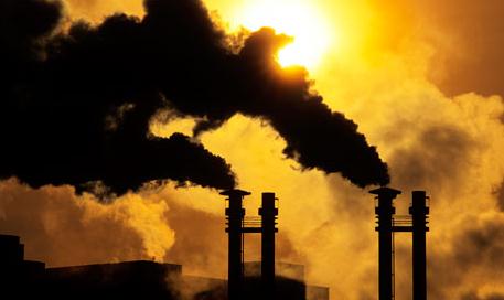
Worst Ever Carbon Emissions Leave Climate On The Brink. Climate "alarmism?" When I watch the news these days I get pretty alarmed - every day seems to bring a new weather calamity. The U.K. Guardian has the story: "Greenhouse gas emissions increased by a record amount last year, to the highest carbon output in history, putting hopes of holding global warming to safe levels all but out of reach, according to unpublished estimates from the International Energy Agency. The shock rise means the goal of preventing a temperature rise of more than 2 degrees Celsius – which scientists say is the threshold for potentially "dangerous climate change" – is likely to be just "a nice Utopia", according to Fatih Birol, chief economist of the IEA. It also shows the most serious global recession for 80 years has had only a minimal effect on emissions, contrary to some predictions. Last year, a record 30.6 gigatonnes of carbon dioxide poured into the atmosphere, mainly from burning fossil fuel – a rise of 1.6Gt on 2009, according to estimates from the IEA regarded as the gold standard for emissions data. "I am very worried. This is the worst news on emissions," Birol told the Guardian. "It is becoming extremely challenging to remain below 2 degrees. The prospect is getting bleaker. That is what the numbers say." Professor Lord Stern of the London School of Economics, the author of the influential Stern Report into the economics of climate change for the Treasury in 2006, warned that if the pattern continued, the results would be dire. "These figures indicate that [emissions] are now close to being back on a 'business as usual' path. According to the [Intergovernmental Panel on Climate Change's] projections, such a path ... would mean around a 50% chance of a rise in global average temperature of more than 4C by 2100," he said. "Such warming would disrupt the lives and livelihoods of hundreds of millions of people across the planet, leading to widespread mass migration and conflict. That is a risk any sane person would seek to drastically reduce."
* "Global Warming: Bleaker and Bleaker". An Op-Ed from the Guardian.
No comments:
Post a Comment