* slight severe storm risk over southern Minnesota - best chance of storms tonight.
* significant cooling trend by midweek, 20 degrees cooler by Thursday & Friday.
Paul's Conservation Minnesota Outlook for the Twin Cities and all of Minnesota:
TODAY: Steamy and hot, chance of a stray T-storm - very humid. Winds: SE 3-8. High: near 90 (dew points in the 70s)
MONDAY NIGHT: Muggy with a better chance of T-storms in the area, some strong to severe (especially south). Low: 70
TUESDAY: "Hot enough for me". Passing T-storm - hottest day so far? High: 93
WEDNESDAY: Hot sun, storms fire south/east of MSP - less humid late in the day. Low: 73. HIgh: near 90
THURSDAY: Partly sunny, more comfortable - big drop in humidity (and temperature). Low: 59. High: 74
FRIDAY: Intervals of sun, storms stay south, over Iowa. Low: 55. High: 72
SATURDAY: Front returns north, more showers, few T-storms. Low: 58. High: 76
SUNDAY: Unsettled, warm & humid, a few T-storms. Low: 62. High: 84
Tornadoes, Hurricanes And Children. In Saturday's column I tried to tackle the subject of kids and severe weather. All it takes is one (scary) storm to create PTSD (post traumatic stress disorder) symptoms. A close encounter with a tornado, hurricane, a flood, even a severe electrical storm, can trigger high anxiety, sleepless nights, even depression:
"Crash, bang, boom, strike, thunk. Disaster coming through now. Damage on the way." That creative little weather haiku is from 8-year old Carson Powell, down at Red Pine Elementary in Eagan. Storm season, what some call the "fifth season", can be traumatic for kids & adults alike. Sudden disasters can create intense fear and anxiety, according to the American Psychological Association. Symptoms include nightmares, tantrums & withdrawal. The APA suggests parents provide more physical affection (let them cling to you), encourage your kids to ask questions, and spend time reassuring them. Tell them the truth: storms are a natural part of life but, much like a fire drill, your family has a plan to keep everyone safe. APA adds "respond to questions in terms they can comprehend. Reassure them repeatedly that you care about them, and that you understand their fears and concerns." Don't minimize their fears. Listen, and turn off the TV so they aren't exposed to violent storm video. A little TLC can go a long way."
- Spend more time with children and let them be more dependent on you during the months following the trauma - for example, allowing your child to cling to you more often than usual. Physical affection is very comforting to children who have experienced trauma.
- Provide play experiences to help relieve tension. Younger children in particular may find it easier to share their ideas and feelings about the event through non-verbal activities such as drawing.
- Be available and encourage older children to ask questions they
may have, as well as sharing their thoughts and feelings with you and with one another. This helps reduce their confusion and anxiety related to the trauma. Respond to questions in terms they can comprehend. Reassure them repeatedly that you care about them and that you understand their fears and concerns. - Keep regular schedules for activities such as eating, playing and going to bed to help restore a sense of security and normalcy, even if your family has been relocated to a shelter or other temporary housing.
- Provide safe opportunities for children to help others - helping others offers a sense of control and can help children feel better about themselves.
- Reduce the number of times children see the trauma on the news. Repeatedly watching broadcasts of the disaster can re-traumatize children."
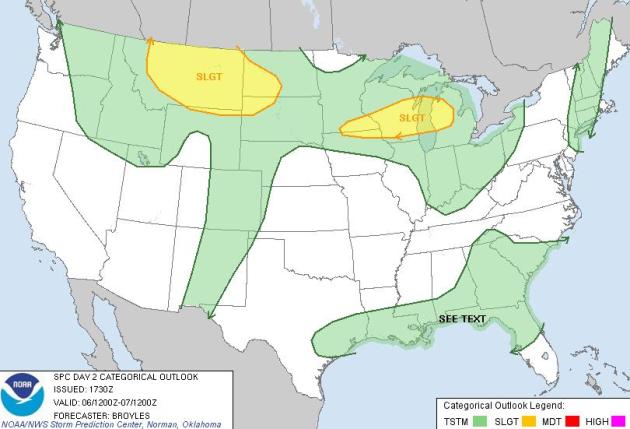
Slight Severe Risk. Speaking of storms, SPC has a "slight risk" of storms over much of southern Minnesota today as a strong warm front surges north - the main risk is hail, with a slight chance of an MCS system, a meso-convective system (a sprawl of strong/severe storms) sweeping across southern and eastern Minnesota into western Wisconsin during the morning hours. Later today (and much of Tuesday) the atmosphere overhead may be "capped", a layer of warm, dry air aloft inhibiting thunderstorm development, especially over southern Minnesota.
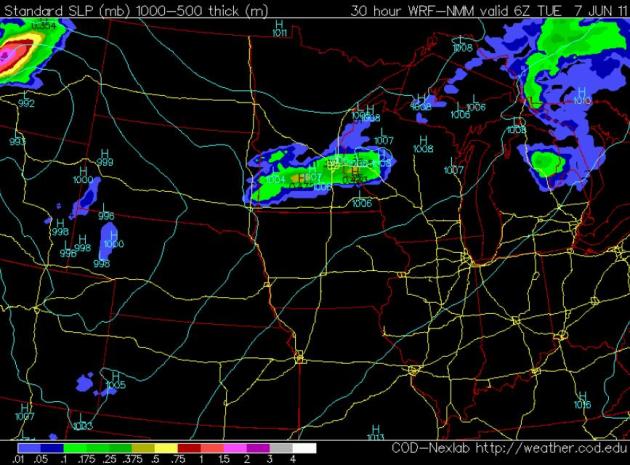
Best Chance of T-storms: Monday night. The 00z NAM is hinting at dry weather much of Monday (low 90s with a dew point spiraling into the 70s). The best chance of storms comes Monday night, a few may be strong, even severe over far southern Minnesota.
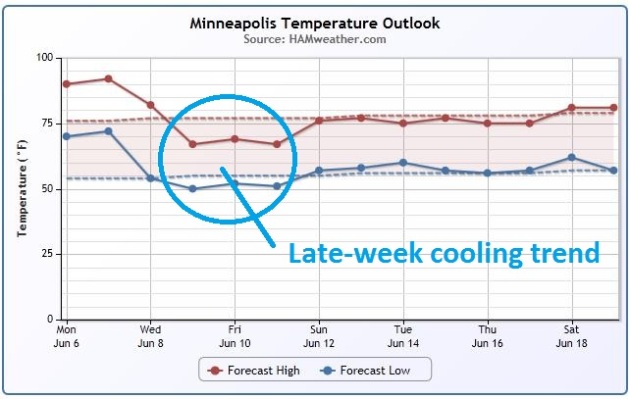
Late Week Cooling Trend. A cooler front arrives Wednesday on west/northwest winds with a (big/welcome) drop in humidity. By Thursday and Friday highs only reach the low 70s, nearly 20 degrees cooler than today & Tuesday.
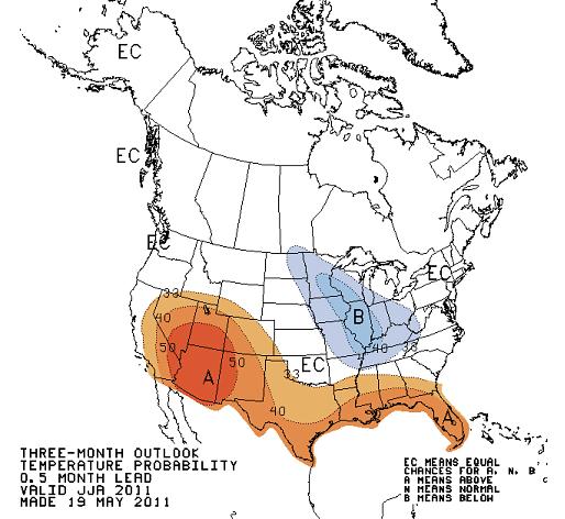
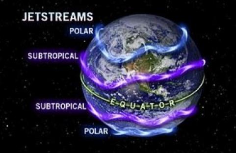
A (Slightly) Cooler, Stormier Summer? CPC, the Climate Prediction Center, is still hinting at a slight cool bias from the Upper Midwest into the Great Lakes and the Ohio Valley, hotter than average for much of the south and the southwestern USA. I wouldn't panic about a "lost summer" (we'll see 2 or 3 90-degree days just this week) - but a jet stream howling almost directly over Minnesota for much of June and July may keep us slightly cooler, with more frequent (severe) storms than usual. I doubt we'll see the 113 tornadoes that swept across Minnesota last year, but I still think we'll see more hail, damaging winds and tornadoes than average.
Prepare Your Home For The "Fifth Season". Granted, it's one of the few things Minnesotans DON'T have to worry about: hurricanes. But many of us have friends and families living in Florida, the Gulf coast or the Atlantic shore - last year we dodged a bullet: the 3rd most hurricanes ever recorded, but they (somehow/magically) avoided hitting the U.S. coast. I suspect we won't be quite as lucky this year. The Sioux City Journal has more details: "Many of us are now planning for the summer season. But, along with summer, don't forget about the "fifth season" that we need to think about. And that season is hurricane season. For the past 10 years, I've been promoting hurricane safety across the country. After Hurricane Katrina hit the Gulf Coast, I worked in the area with various groups and sadly saw the damage firsthand. This led to my No. 1 rule when it comes to preparedness: If told by officials to evacuate or seek shelter, do so as quickly as possible. That said, many of us may experience a close call rather than a direct hit from a hurricane, tornado or other major storm. This is where preparation for power failures and home damage can help you and your family. Here are three basic tips that should be addressed to help prepare your home and family:
-- Standby electrical power: Keeping key electrical appliances like refrigerators, sump pumps and well pumps running is a major factor in getting through a weather-related event. Portable generators can do the job with some extra effort and planning. But, having a permanently installed standby generator connected directly to your home can offer the ultimate in automatic backup electrical power. Residential standby generators usually run on propane or natural gas, making them a natural choice for extended periods of use during long power outages.
-- Water storage: Store plenty of drinking water, and we all know that filling up the bathtub before a major storm can give you stored water for things like washing up. But during a power outage you can also get washing water from your home's water heater. Shut down all fuel valves and/or breakers and let the water cool before you drain your tank. Then have a plumber refill and start the water heater when the storm event is over."
North Carolina wind/hail:
http://www.youtube.com/watch?v=QetGE1L91IA&hd=1
California heavy rain:
http://www.youtube.com/watch?v=hCsx6kunub0&hd=1
Council Bluffs flooding:
http://www.youtube.com/watch?v=YuHa56jt45M&hd=1
http://www.youtube.com/watch?v=kK2N60hfVto&hd=1
http://www.youtube.com/watch?v=3iThwJaGKlg&hd=1
http://www.youtube.com/watch?v=VY5ynuqkBJA&hd=1
MO River flooding SD:
http://www.youtube.com/watch?v=dUIhPJQybT0&hd=1
Oregon hail:
http://www.youtube.com/watch?v=fVnOsys_zB4
http://www.youtube.com/watch?v=YkDuWhqkKo4
Hooks, TX hail:
http://www.youtube.com/watch?v=VPu0203qtuI
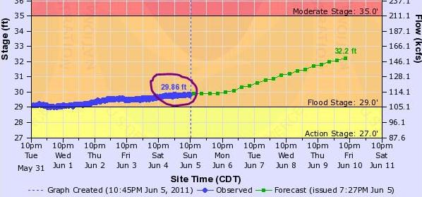
Flood Potential. The Missouri River At Omaha is forecast to rise 2 feet above 1993's record flood stage by Friday. Source: NOAA.
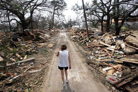
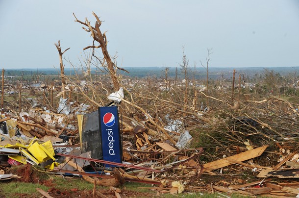
Massachusetts Tornado Surprises And Scares Us All. Thestir.com has more on last week's huge EF-3 tornado: "Growing up in the Midwest, one learns to expect tornadoes. But on the East Coast, specifically in Massachusetts, they're a bit of a shock. The tornado that ran through Western Massachusetts on Wednesday, killing three and injuring many others, was a surprise to all of us who live in the area. And with hurricane season on its way, it may get worse for Massachusetts before it gets better. Though Massachusetts doesn't have a reputation as a tornado state, there have been deadly tornadoes in the past, including one in Worcester nearly 60 years ago that was one of the deadliest in the country's history. The tornado that tore through Western Massachusetts on Wednesday was only a lightning storm to those of us who live near the city, but out west, it was devastating."
Attack Of The Urban Tornadoes. Bad luck, a statistical fluke, evidence that climate change is making tornadoes more severe? AccuWeather and the cuttingedgenews.com has the story: "AccuWeather.com reports not only is this the year of the tornadoes, but it also seems to be the year of the urban tornadoes. Chance, a shift in the jet stream and expanding population centers are the main reasons for the number of tornadoes striking towns and cities this year. The list of towns and cities being hit by tornadoes this year continues to grow along with the number of tornadoes. According to the National Weather Service's Storm Prediction Center, as of 9:00 a.m. CST, June 2, 2011, there have been 1,425 reports of tornadoes thus far this year. This is already above the 3-year average of 1,376 and of course, this year is far from over. Of the preliminary number of tornadoes, there seems to be an unusually high number of towns and major cities that have been hit thus far this year. With the aid of small, pocket video cameras, we have all been able to watch in horror as tornadoes hit major population centers. Here is a partial list of towns and cities hit by tornadoes this year: Starkville, Jackson, Philadelphia and Smithville in Mississippi, Rayne, Slidell and Nachitoches in Louisiana, Lakeland in Florida, Mapleton in Iowa, Merrill and LaCrosse in Wisconsin, Atoka and Oklahoma City in Oklahoma, Little Rock and Hot Springs in Arkansas, Tuscaloosa (twice), Huntsville and Birmingham in Alabama, Raleigh/Sanford in North Carolina, St. Louis and Joplin in Missouri, Bristol in Virginia, Philadelphia in Pennsylvania, Reading in Kansas, Minneapolis in Minnesota, Dallas in Texas and Springfield (twice) in Massachusetts."
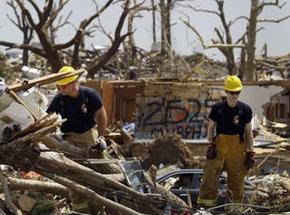
NOAA Technology Helps American Red Cross Respond Faster. The press release from NOAA: "In this record-breaking spring tornado season, emergency responders are saving precious hours when they count the most – in the immediate aftermath of a devastating storm strike. A tool developed by the NOAA National Severe Storm Lab (NSSL) has cut disaster assessment time dramatically for the organizations, state, and federal agencies that have adopted it. The American Red Cross of Central Oklahoma, for example, is using the NSSL Warning Decision Support System—Integrated Information (WDSS-II) to shorten the time it takes to deliver assistance to the neighborhoods ripped apart by tornadoes. Real-time information from the system can be plotted on maps, for example, speeding up the response process. “This technology cut our disaster assessment time down from 72 to 24 hours,” said Steven Klapp, a volunteer and disaster assessment team leader for the American Red Cross of Central Oklahoma. Klapp has trained more than 250 people in Oklahoma and Texas to use the technology to support disaster recovery operations. American Red Cross Disaster Assessment teams were out in full-force the morning following the Tuesday, May 24, tornado outbreak in central Oklahoma. Their responders used the NSSL software tool to direct them where to go. The tool helps the Red Cross to pinpoint when and where damage caused by severe weather most likely occurred. The system uses the Internet to draw data from a nationwide network of weather radars, satellites, surface observations, and lightning detectors."
Insurers And Reinsurers Are Nervous. Don't be surprised if your insurance rates climb the next time you pay your premium. Record flooding, tornado outbreaks and other (expensive) examples of extreme weather have a way of being passed on to all of us, as reported by WJHG-TV: "Tornadoes and floods taking lives and destroying homes throughout the country could raise the price Floridians pay for property insurance. The multibillion dollar price tag is taking a toll on nationwide reinsurance companies. Those companies could pass the pain on to Florida insurers, who could pass the cost on to you. This isn't hurricane damage. This isn’t even Florida. But the tornadoes that ripped through Alabama a month ago could raise the price you pay for insurance. So might the tornado that hit Massachusetts Wednesday and the record flooding in South Dakota. Tonya Toole has been watching the destruction from her Florida beach home. “We had heard we may have more serious major hurricanes here in Florida this season.” Tonya chose to retire on the beach. She loves the scenery. Thursday she painted a tropical bird to hang in her home. But life’s not always a beach on the coast. Tonya, pays more for insurance because of hurricane threats. “I take the responsibility of being in a high risk area.” But just days into hurricane season, the biggest threat to her insurance premium isn’t a tropical storm. It’s disasters in other parts of the country. Those storms will make it more expensive for Florida insurers to buy reinsurance."
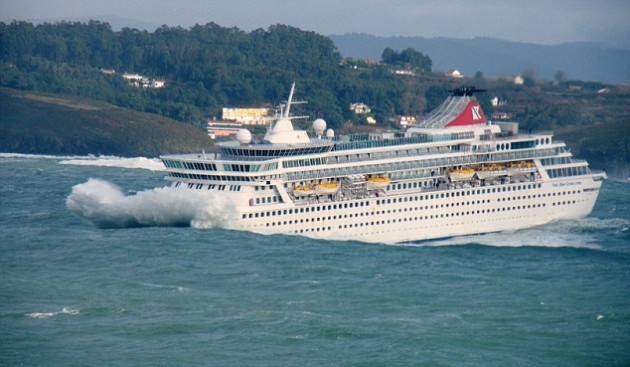
Cruise Lines Say They Are Prepared For Hurricane Season. If you book a cruise for September/October realize that this is prime-time for hurricanes. The Montreal Gazette has more details: "The Atlantic hurricane season is officially underway, and it will have a sixmonth run. Words like "hurricanes" and "tornadoes" always sound ominous, especially right now and, for cruisers, especially "hurricanes." Every year, these Atlantic storms have their genesis in Africa and they either die or start to build as they make their way west across the ocean. Every year - right about now - I start to get emails from people asking if it's safe to book a cruise during hurricane season. The short answer is yes, with the caveat that you must be prepared for possible changes in your routings. NOAA (the U.S. National Oceanic and Atmospheric Administration) is the main source for hurricane information and, with its hurricane centre in South Florida, is the ideal supplier of information to cruise lines. Last week, NOAA announced its predictions for this year's hurricane season. The forecast is there will be 12 to 18 named storms, of which six to 10 will become hurricanes and three to six will become major hurricanes."
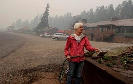
Arizona Forest Fire Triggers New Evacuation Orders. AP has the latest on massive fires racing across much of Arizona: "GREER, Ariz. (AP) -- Authorities ordered more eastern Arizona residents to evacuate their homes Sunday as a 225-square-mile blaze that has grown into the third-largest in state history crept toward more buildings. The Apache County sheriff's office told an unknown number of people east of the town of Alpine along U.S. Highway 180 to get out as the forest fire crept closer. Alpine itself has been under mandatory evacuation orders since Thursday night, along with the community of Nutrioso and several lodges and camps in the scenic high country. Subdivisions close to the New Mexico border that were ordered emptied Sunday included Escudilla Mountain Estates, Bonita, Dog Patch, and the H-V Ranch east of Highway 180, fire information officer Eric Neitzel said. People packed up their belongings as smoke covered the mountain vacation towns in a smoky fog, and wind blew smoke from the burning pine forest well into nearby New Mexico and Colorado."
June Rainfall In San Francisco Shatters Records. AccuWeather has an update on the persistent rains (and mountain snows) plaguing much of the west coast: "A stubborn storm system parked off the California Coast is dumping record rainfall over portions of the Golden State. With the locally heavy rain on Saturday, San Francisco has already set its all-time wettest June on record. The 0.97 of an inch of rain recorded so far this June surpassed the previous record for wettest June, when 0.86 of an inch fell in June of 1967. The rain that has fallen so far this month in San Francisco is nearly nine times the normal rainfall received in the entire month of June. AccuWeather.com Meteorologist Cory Mottice examined the rainfall amounts in the city, noting that San Francisco has more than doubled its average rainfall for four months in the past four days!
-Oakland Museum: 1.45 inches (Old record 0.10 of an inch from 1993)
-San Jose International Airport: 0.78 of an inch (Old record 0.18 of an inch from 1993)
-Monterey: 0.83 of an inch (Old record 0.28 of an inch from 1993)."
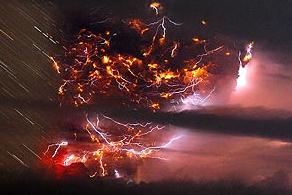
Lightning Turns Volcanic Ash Cloud Into Light Show. NDTV.com has the story of a spectacular volcanic eruption in Chile: "Santiago: "Flights in the region were canceled and more than 3,500 people stayed away from their homes near the volcano, which produced an eerie show of lightning dancing through its clouds of ash overnight.
A volcano in the Caulle Cordon of southern Chile erupted for a second day Sunday, shooting out pumice stones and pluming a cloud of ash six miles (10 kilometers) high and three miles (five kilometers) wide."
Volcanic Eruption in Chile. Image above courtesy of Twitpic.
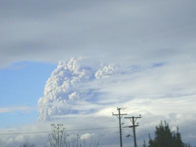
Volcanic Fall-out. Just downwind of the volcanic eruption the ash-fall was dramatic.. Photo courtesy of Twitpic.
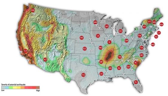
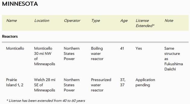
Interactive Map Shows Earthquake Risks To America's Nuclear Power Plants. The story from climatecentral.com: "In their new June 2011 issue, Scientific American magazine has published a story investigating the safety of the newest generation of nuclear power plants (a digital subscription is required for access). To accompany the story, the online team has produced a new interactive graphic available to everyone that pinpoints each of the 104 nuclear reactors across the United States (and the locations of 22 proposed new reactors). Similar to the map Climate Central’s David Kroodsma produced in March 2011, immediately following the nuclear disaster at the Fukushima Daiichi facility in Japan, this new map compares the location of American plants to regions of high earthquake risk (Climate Central's interactive tracked the location of previous earthquakes). Compiling reactor data from the Nuclear Regulatory Commission (NRC) and seismic hazard data from the U.S. Geological Survey (USGS), the SciAm graphic shows that there is already a handful of U.S. nuclear power plants located in earthquake-prone areas of the country. The threats aren't just to reactors in California and Washington State; some located in South Carolina, Tennessee, Arkansas and Missouri are also along the fringe of seismically active regions. "
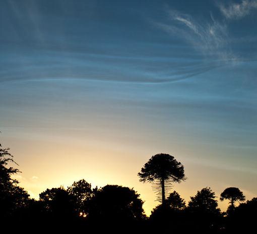
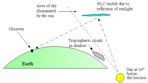
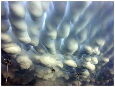
Noctilucent Clouds Over Europe. Spaceweather.com has an explanation for these rare and beautiful clouds in the upper atmosphere: "The 2011 noctilucent cloud (NLC) season has begun. For the past few nights, observers across northern Europe have spotted velvety, electric-blue tendrils rippling across the sunset sky. John Houghton sends this picture from Newtown Linford, Leicester, UK: "This was the best display of noctilucent clouds I've seen to date," he says. "It was visible even before sunset." NLCs are a summertime phenomenon. In the upper atmosphere, 80+ km high at the edge of space itself, tiny ice crystals nucleate around microscopic meteoroids and other aerosols; when the crystals catch the rays of the setting sun, they glow electric blue. Ironically, these highest and coldest of clouds form during the warmest months on the ground."
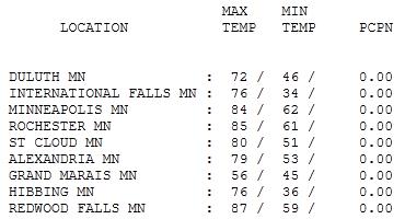
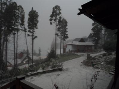
Spectacular Sunday. The weather turned out even nicer than expected yesterday (instability showers never materialized up north - sunshine was the rule statewide). Highs ranged from a nippy 56 at Grand Marais to 80 in St. Cloud, 84 in the Twin Cities and 87 at Redwood Falls.
Hot & "thundery"
"Hey Paul, what's the long-range outlook for Minnesota?" Hmm. I'll pause, frown, pretend to check some fancy new app on my iPhone, and then reply in a deadpan monotone. "Changeable." That I can predict with (rare) 100% accuracy. A little over a month ago we were still tracking flurries & wind chill. This week beloved neighbors will be whining about the heat & humidity. If only summer was on a dimmer switch. But as is so often the case here in the Land of 10,000 Weather Insults, the heat is either ON or OFF.
Today's hot frontal passage will set off more T-storms, some potentially severe; there's a slight chance of an "MCS" T-storm "swarm" early today.
The big story: the heat. Highs nick 90 F. through midweek with a drippy dew point surging into the 70s. That means a "heat index" near 100 each afternoon; up in the oh-zone. Looks like Mother Nature is about to make up for lost time. Some good news: a cooler front arrives by late week, highs in the 70s with a welcome dip in humidity.
Finally, a plea for brides planning outdoor weddings in the coming weeks. June is the wettest (4") - and most severe month of the year in Minnesota. Do yourself a big favor. Rent the tent.
Climate Change: Is Weird Weather An Anomaly? The story from the Marietta Times: "Severe flooding and deadly tornadoes this spring - and even Marietta's record rainfall in April - have some people wondering whether recent unusual weather is an anomaly or a sign of things to come as a result of the Earth's changing climate. According to a meteorologist who studies the subject, it's hard to say how much of a factor climate change is in the recent severe weather, but it does play a role. "There is more water in the atmosphere and the temperatures are warming," said Robert Henson, writer/editor with the University Corporation for Atmospheric Research in Colorado and author of "The Rough Guide to Climate Change." "The kinds of rainfall we've been having are consistent with climate change." But Henson said other conditions play a role and it can't be determined whether climate change is, say, 25 or 50 percent responsible for Mississippi River flooding that still has thousands of acres of farmland underwater. "There are a lot of things in the mix going on at any one location," he said. Area residents have taken note of the bizarre weather but many are more concerned about specific incidents than a change in the Earth's climate."

Climate Of Fear: Scientists Face Death Threats. It's come to this? Climate scientists in Australia are being intimidated, emotionally and now physically, according to the Canberra Times (courtesy of Climate Change: The Next Generation):
"Australia's leading climate change scientists are being targeted by a vicious, unrelenting email campaign that has resulted in police investigations of death threats. The Australian National University has confirmed it moved several high-profile climate scientists, economists and policy researchers into more secure buildings, following explicit threats to their personal safety. Scientists at universities in NSW and Queensland have told of being moved to high security buildings, where their names do not appear on staff directory lists or on their office door. ''If you want to find me, it's impossible unless you make an appointment, sign in with some form of photo identification, and are personally escorted to my door,'' one scientist said. ''That's directly as a result of threats made against me.'' More than 30 researchers across Australia ranging from ecologists and environmental policy experts to meteorologists and atmospheric physicists told The Canberra Times they are receiving a stream of abusive emails threatening violence, sexual assault, public smear campaigns and attacks on family members."
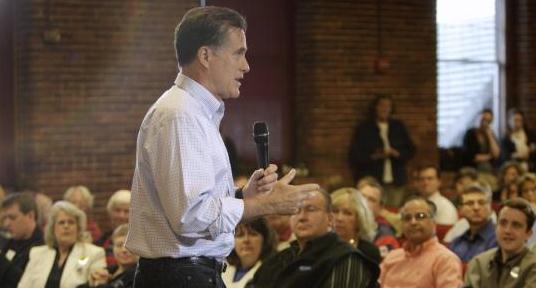
Romney: "Important" To Reduce Emissions To Counter Climate Change. WBUR-TV has the story: "And so voters, presumably, were trying to figure out Romney’s stance on things Friday. Did he elaborate on any of his policy positions or reveal any new policy positions?
He actually did. Generally, in this beginning presidential campaign here, you’re seeing Republican presidential candidates try to stay away from supporting the idea of climate change. Romney did not do that Friday. He staked out a position admitting that there really is climate change. I don’t speak for the scientific community, of course, but I believe that the world is getting warmer, and No. 2, I believe that humans contribute to that. And so I think it’s important for us to reduce our emissions of pollutants and greenhouse gases that may well be significant contributors to the climate change and the global warming that you’re seeing.So he didn’t shy away from that?
Not at all.
So that’s one issue. What about health care reform? Romney has been taking a lot of flack, of course, about his involvement in health care reform in Massachusetts. Assuming that issue came up, how did he respond?
Well, he reiterated his position that people who have preexisting conditions and already have insurance coverage now, they shouldn’t lose that coverage. But he did make it clear that under a Romney administration, if you have a preexisting condition and you do not already have insurance, you might be left high and dry."
Global Warming Crisis May Mean World Has To Suck Greenhouse Gases From Air. The U.K.'s Guardian reports: "The world may have to resort to technology that sucks greenhouse gases from the air to stave off the worst effects of global warming, the UN climate change chief has said before talks on the issue beginning on Monday. "We are putting ourselves in a scenario where we will have to develop more powerful technologies to capture emissions out of the atmosphere," said Christiana Figueres, executive secretary of the UN framework convention on climate change. "We are getting into very risky territory," she said, stressing that time was running out. The UN climate talks starting on Mondayin Bonn, which run for the next two weeks, will try to revive the negotiations before the next climate conference, taking place in Durban, South Africa, in December. But little progress is expected, as the negotiating time is likely to be taken up with details such as rules on monitoring emissions. Figueres tried to inject a greater sense of urgency into the proceedings by pointing to research from the International Energy Agency that found that emissions had soared last year by a record amount. The strong rise means it will take more effort by governments to curb emissions."
The New Normal. Vermont's timeargus.com has the story: "Climate change is no longer a theoretical idea. It is already here, and government has been forced to respond. The floods that swept through central and northeastern Vermont nine days ago were a unique weather event and by themselves are not evidence of a changing climate. But the floods fit the pattern of extreme weather that experts have been observing and point to a larger problem. For the past decade, every year seems to have set a record as the hottest or been nearly the hottest. And hot weather does several things. In some places it produces drought, as it has in Russia and Australia, resulting in devastating, crop-destroying wildfires. Hot weather also causes more rapid evaporation, which puts a greater quantity of water into the atmosphere, producing more snowfall and rainfall. Hurricane Katrina in 2005 was just one of the extreme events that have caught the attention of scientists who have perceived a greater frequency of extreme events. This year an unusually high number of tornadoes have caused severe damage, not just in places where tornadoes are expected, such as Missouri, but in Springfield, Mass. This winter in Vermont was one of the snowiest ever. The spring that followed was the wettest. So when a heavy downpour fell in the area from Montpelier to St. Johnsbury on the night of May 26, the ground was already saturated and the rain could only rush into already swollen rivers, which overtopped their banks and damaged numerous businesses and homes, including the press in Barre that prints The Times Argus and Rutland Herald. No one weather event signals climate change. Put it all together, and it becomes hard not to see that something larger is going on. State officials have noticed. “We are in a mode of responding to emergencies and recovering,” said Sue Minter, deputy secretary of transportation. “But as we look to the future we have to at least envision or assess if this will become the new normal and be prepared for that. It does change the way we think and plan. Or it should.”
Declare War On Climate Change. Richmond's Times Dispatch has the post: "As record flooding completes its destructive journey along the Mississippi River, accounts label this disaster the "flood of the century," implying we probably won't see such an event for another 90 years. Well, I've got 50 bucks that says we'll see at least two more floods of the century before the decade is out. Welcome to the new normal, brought to you by the heat-trapping gases that warm our planet and increase the amount of water our atmosphere holds and releases. Yes, floods are nothing new; just ask Noah. What is new, however, is the frequency and severity of extreme-weather events, which increase as the mercury on the thermometer rises. So severe, in fact, that the Army Corps of Engineers made the decision to sacrifice a number of small towns in Louisiana in order to spare New Orleans from another Katrina-like disaster."
No comments:
Post a Comment