*
Note to Conservation Minnesota readers:
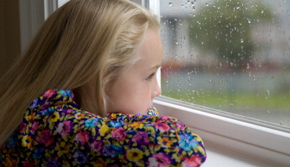
What do we have to do, who do we have to bribe, to experience a nice, sunny (summerlike) Saturday statewide? My apologies for yesterday's "bust". Yes, we know when we're wrong. A friend walked up with a copy of the Star Tribune weather page, pointing to the "sunshine" prediction with a big smirk on his face. "What happened, Paul?" Yes, the prediction called for "partly sunny", and the sun was out much of the day north/west of St. Cloud. That didn't do residents of the Twin Cities any good. I could SEE the clearing line 30 miles to the north & west of MSP much of the day. What happened? A storm in the upper atmosphere (one of those dreaded "upper air disturbances" meteorologists like to babble about) drifted over southeastern Minnesota, brushing the MSP metro with patchy clouds and a few light showers and sprinkles. No excuses, but this bears repeating:
I have never, ever seen a year like this. Ever. Not only is the weather more extreme, it's harder than ever to predict. The south is experiencing an historic drought with tens of thousands of wildfires so far this year - while the north is unusually cool, wet & stormy. This huge north-south temperature contrast is whipping up unusually strong winds over the nation's midsection, helping to spin up severe storms (more than 18,000 reports of severe weather so far this year), and an unprecedented number of large, violent (and deadly) tornadoes. The models are more useless than usual. We're in new &
uncharted territory. We're doing our best to provide you with reliable weather information, but please know the truth:
something has changed. From a meteorological standpoint it's fascinating, and more than a little bit troubling.
"...
So far this storm season, four tornadoes have occurred in the seven county Twin Cities metro area, and six tornadoes have been documents within 25 miles of Minneapolis. One of these on May 22nd was responsible for one fatality, and approximately 30 injuries in North Minneapolis." - National Weather Service, in a post below highlighting the risk of tornadoes in major, urban areas.
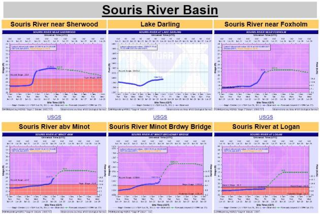
 Minot Flood Update
. According to NOAA and the Army Corp of Engineers the situation in Minot has "stabilized". Based on flow levels upstream the expected crest has dropped by nearly 2 feet, still 3-4 feet above the previous historic crest in 1881. Details below.
 "...But it is highly improbable that the remarkable extreme weather events of 2010 and 2011 could have all happened in such a short period of time without some powerful climate-altering force at work. The best science we have right now maintains that human-caused emissions of heat-trapping gases like CO2 are the most likely cause of such a climate-altering force." - Dr. Jeff Masters in a comprehensive Wunderblog entry, documenting the historic weather extremes of 2010-2011. This is a must read.
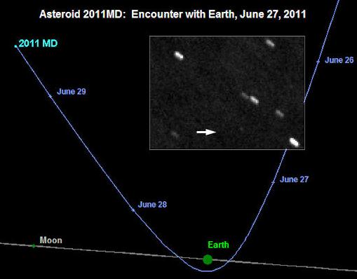
 "Don't Sweat The Thunderstorms." Monday morning at 8:30 a 20 meter wide asteroid will pass within 7,500 miles of the Earth's surface, actually entering the upper atmosphere. NASA insists it won't hit our dear planet. Details below.
 Fireworks Ban
. It's so dry across the south that many communities from Texas to Arizona have BANNED fireworks for the 4th of July. Seems un-American, but these draconian measures are necessary due to an exceptional drought, and an extreme risk of more wildfires. Details below.
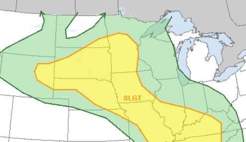 Slight Severe Risk Later Today
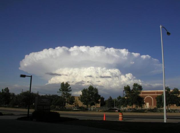
. SPC has much of central and western Minnesota in a "slight risk" of severe storms later today. The latest NAM pulls in respectable levels of CAPE (2000+) and a lifted index of -5 by evening, meaning significant instability, coupled with ample wind shear. A few supercell thunderstorms capable of large hail and even an isolated tornado are possible later, especially over western Minnesota. I expect some watches/warnings later today - stay alert.
 Better Than Yesterday?
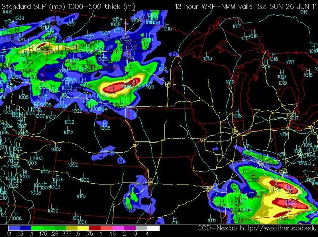
 Saturday's forecast was a bust, at least from the Twin Cities on south/east. Much of central and northern Minnesota salvaged a pretty good day with ample sun, but a (small) storm in the upper atmosphere kept the atmosphere south/east of MSP
unsettled and showery part of the day. The sun should be out morning and midday hours, but the risk of T-storms will increase later, from west to east, and a few of the storms may turn severe. NAM model map above valid at 1 pm today.
Recent Events Serve As A Reminder That Tornadoes Can Strike Cities. The local NWS office in Chanhassen published
this timely post, a wake-up call for people who believe that tornadoes can't hit major, urban areas: "
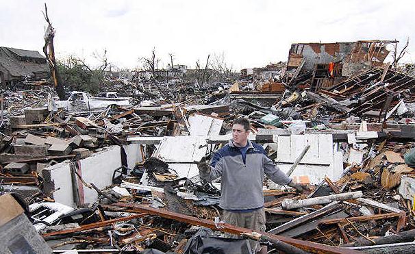
The degree of tornado damage across the country during the past three months has been devastating. Tornadoes thus far have caused a preliminary 537 fatalities and many more injuries. Thousands of homes and businesses have been destroyed, including in densely populated areas. It is a lengthy list of cities that have had tornado occurrences so far in 2011. Some city metropolitan areas that have seen strikes by significant tornadoes (those rated as EF-2 or stronger on the Enhanced Fujita scale) include Birmingham, Jackson Mississippi, Joplin, Little Rock, Louisville, Raleigh, Saint Louis, Springfield Massachusetts, and Tuscaloosa. Other metropolitan areas have seen damage by EF-0 or EF-1 tornadoes, including Chicago, Philadelphia, and the Twin Cities. So far this storm season, four tornadoes have occurred in the seven county Twin Cities metro area, and six tornadoes have been documented within 25 miles of Minneapolis. One of these on May 22nd was responsible for one fatality and approximately 30 injuries in North Minneapolis. Tornadoes can happen anywhere. Densely populated areas are every bit as susceptible to tornado strikes, including violent tornadoes such as those that struck Joplin and Tuscaloosa. Last year, Minnesota saw four violent tornadoes of EF-4 intensity. On May 6th 1965, a tornado outbreak with four violent tornadoes occurred within and very near what is now the Twin cities and surrounding suburbs. It is simply a myth that cities are safe from tornadoes. Tornadoes have happened and can happen in cities, including the Twin Cities."
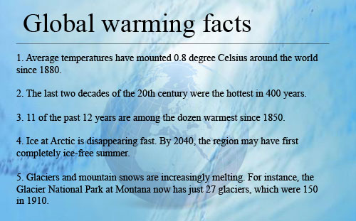
Historic Weather Extremes....Bordering On The Surreal:
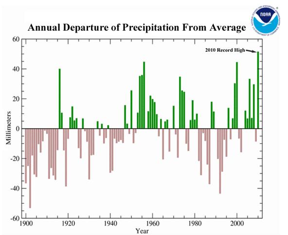
2010: Wettest Year On Record Worldwide.
Earth's Most Extreme Weather Since 1816? From Dr. Jeff Masters and his excellent
Wunderblog: "
Global departure of precipitation over land areas from average for 1900 - 2010. The year 2010 set a new record for wettest year over land areas in Earth's recorded history. The difference in precipitation from average in 2010 was about 13% higher than that of the previous record wettest year, 1956. Image credit: NOAA's National Climatic Data Center.
Every year extraordinary weather events rock the Earth. Records that have stood centuries are broken. Great floods, droughts, and storms affect millions of people, and truly exceptional weather events unprecedented in human history may occur. But the wild roller-coaster ride of incredible weather events during 2010, in my mind, makes that year the planet's most extraordinary year for extreme weather since reliable global upper-air data began in the late 1940s. Never in my 30 years as a meteorologist have I witnessed a year like 2010--the astonishing number of weather disasters and unprecedented wild swings in Earth's atmospheric circulation were like nothing I've seen."
Don't Sweat The T-storms....
Near-Miss? Some reasurring news from NASA, courtesy of spaceweather.com: "Newly-discovered asteroid 2011 MD will pass only 12,000 kilometers (7,500 miles) above Earth's surface on Monday June 27 at about 9:30 a.m. EDT. NASA analysts say there is no chance the space rock will strike Earth. Nevertheless, the encounter is so close that Earth's gravity will sharply alter the asteroid's trajectory. At closest approach, 2011 MD will pass in broad daylight over the southern Atlantic Ocean near the coast of Antarctica. As the asteroid recedes from Earth, it will pass through the zone of geosynchronous satellites. The chances of a collision with a satellite or manmade space junk are extremely small, albeit not zero. Judging from the brightness of the asteroid, it measures only 5 to 20 meters in diameter. According to JPL's Near Earth Object Program office, one would expect an object of this size to come this close to Earth about every 6 years on average. For a brief time, it will be bright enough to be seen even with a medium-sized backyard telescope. [observing tips] [3D orbit]
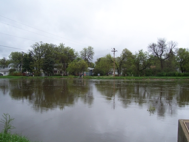
. According to the National Weather Service the situation in Minot has "stabilized" - a crest later today now expected to be 2 feet LESS
than earlier predicted, but still well above the historic flood crest set in 1881.
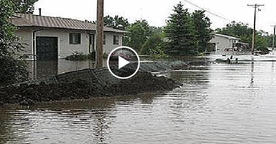
Neighbors, Stranger Aid Minot Flood Victims. The
Star Tribune has a story about how the Great Flood of '11 is bringing out some of the best in people: "
MINOT, N.D. - As the Souris River rose relentlessly beyond its banks and swept over levees on Friday, the people of Minot came together as North Dakotans do -- with fortitude, determined generosity and few words. While more than 10,000 people were evacuated from areas ravaged by the worst flood in this city's history -- roughly a quarter of the population -- only 225 sought refuge in two shelters set up by the Red Cross. Residents on high ground took in those from low. Some lent campers to the newly homeless. Others offered trucks and trailers along with their strong arms and backs to move evacuees' possessions to safe havens. With the state's oil boom and an influx of new workers, few, if any, apartments and hotel rooms could be found. "We were prepared for about 800 people," said Susan Ewertt, the newly named site director of disaster operations for the Mid-Dakota Red Cross. "The community has been great. It speaks so highly of their kindness." Erin McCabe discovered that firsthand Friday afternoon, as friends and a few strangers emptied her modest home on the city's west side into four pick-up trucks idling at the curb. "To tell you the truth, I'm not sure who all these people are," said McCabe, still wearing her Air Force flight suit and hoisting her befuddled 4-year-old daughter, Anna."
Rainfall: Abundant and Persistent. Here's an excerpt from this week's WeatherTalk, from Professor Mark Seeley. Yes, it's been a very wet June: "Some of our Minnesota observers have reported rainfall on 13-14 days so far this month. In addition many are reporting above normal amounts, ranging from 5 to 7 inches. Among those reporting June rainfall of 5 inches or greater:
Blue Earth 5.80" Faribault 7.82" Lake City 7.83"
La Crescent 7.01" Theilman 6.55" Ortonville 5.34"
Worthington 5.36" Fairmont 5.37" Hastings 5.54"
Following a wetter than normal April and May most soils have had little time to dry out. Consequently farmers are having a difficult time getting equipment into the fields in order to do weed control or supplemental fertilizer applications. Fortunately it looks like a drier and warmer weather pattern may prevail for the conclusion of June, after record rains and cool daytime temperatures this week. MSP tied a record cold maximum temperature with just 63 degrees F on Thursday, June 23rd, while Moose Lake reached a high of only 52 degrees F that same day."
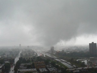
Rash Of Disasters Raising Concerns About Emergency Response Resources. The Star-Telegram in Texas has the story: "In April, tornadoes tore through the Southeast, flattening neighborhoods and killing almost 240 people in Alabama. A month later, a massive tornado packing 200-mph winds killed 142 people and injured 900 others in Joplin, Mo. And large wildfires continue to blaze in Arizona, scorching hundreds of thousands of acres and devouring homes. Those are just some of the disasters that have triggered responses from the Federal Emergency Management Agency this year -- and hurricane season only arrived this month. Despite the frantic pace, FEMA officials say they are prepared for whatever blows ashore this summer. "It's been very, very busy. We've definitely had the entire gamut," said Tony Russell, FEMA's Region VI administrator in Denton. "But I haven't seen any issues with us not being able to support our governors to the fullest." FEMA has declared 45 major disasters this year and is assisting recovery for past disasters, including some of the 81 declared in 2010. This year, the agency also declared seven emergencies and awarded dozens of fire management assistance grants, including 33 in Texas. The pace has raised worries that the agency will run out of relief money. Congress appropriated $2.7 billion for the FEMA disaster relief fund in fiscal 2011, which ends Sep. 30. More than $4.5 million in unused funding was also made available, according to FEMA in Washington. The fund now has about $2 billion remaining, officials said.
. Here is a NOAA, high-resolution visible satellite image of the squall line bearing down on Joplin on April 27.
2011 Year-to-Date (and record annual) Statistics (as of June 15)
- NWS’s preliminary estimate is that there have been approximately 1,475 tornadoes so far this year.
- The previous yearly record number of tornadoes was set in 2004 with 1,817.
- The overall yearly average number of tornadoes for the past decade is 1,274.
- The preliminary estimated number of tornado fatalities so far this year is 536. NWS records indicate that there were 365 tornado fatalities before the Joplin event. There were 151 fatalities from the Joplin tornado. An additional 18 fatalities were reported in KS, OK, and AR from a tornado outbreak on May 24, 2011.
- 2011 is preliminarily the 6th deadliest tornado year in U.S. history.
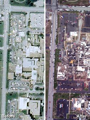
Grim Before & After. The photo above shows St. John's Hospital before and after the Joplin tornado. Courtesy: NOAA.
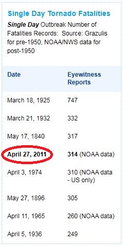
An Historic Outbreak. In spite of Doppler radar, timely warnings, and SKYWARN spotters sending back a real-time stream of information from the scene, over 300 people died from tornadoes on April 27, the 4th greatest loss of life in a single day from tornadoes ever recorded. The stark reality: if an EF-4 or EF-5 tornado is approaching, and you don't have access to a basement, or a reinforced (concrete/steel) "safe room" near the center of your home, the odds of survival are not good. Data courtesy of NOAA.
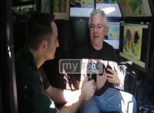
"They're More Than Just Storm Chasers".
MyFox Tampa tags along with a storm chaser I respect, Josh Wurman, who doesn't chase tornadoes for fame, glory (or money). He's trying to learn more about how tornadoes form, what makes them tick, why some go on to become monsters, while others fizzle: "
TAMPA - Dr. Josh Wurman and his research team have become household names among weather enthusiasts for their roles in Discovery's tornado-chasing TV series 'Stormchasers.' They're happy to talk about their work -- just don't call them 'storm chasers. "I actually prefer 'meteorologist' or 'researcher' because we're chasing these different kinds of storms for a reason," he told FOX 13. "We're trying to learn important things about them so that we can forecast them better." Dr. Wurman's team is based out of Colorado. Most years, they hit the roads with their Doppler on Wheels (DOW) mobile radar truck to track tornadoes. But they also track other weather phenomena, including hurricanes. "We've been in a dozen hurricanes, some in Florida, and we drive these trucks and other vehicles with other instruments right up to where we think the eye is going to make landfall," Wurman explained. "Then we deploy our instruments into this dense area right as the eye comes onshore. And we're trying to measure the winds, gusts, the relationship between the winds and how the damage occurs in different neighborhoods so we can learn more about how exactly hurricanes do damage."
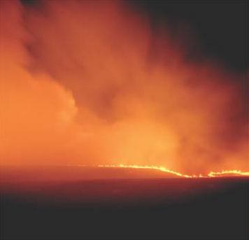
"The Perfect Firestorm". Fire season started early this year (wildfires usually peak in August and September). It's unusual to have so many fires so early in the summer season (an estimated 33,000+ separate fires).
Audubon Magazine has an overview on the conditions that may result in a record year for fire across the USA:
"Welcome to the new era of “megafires,” which rage with such intensity that no human force can put them out. Their main causes, climate change and fire suppression, are fueling a heated debate about how to stop them. At the Rocky Mountain Research Station’s Fire Sciences Lab in Missoula, Montana, chemists, physicists, fire behavior analysts, ecologists, life scientists, and engineers gather in a cavernous combustion chamber, playing with fire. Stands of metal are draped with what looks like wooden tinsel, made from shredded aspens. The four-foot-high “trees” stick out of an adjustable platform that’s four feet wide and 24 feet long, and can be tilted to mimic a section of the 25-degree south-facing slope of a ponderosa pine forest or the steeper high-alpine terrain of a spruce–fir forest. A huge exhaust hood with smoke sensors hovers over the pad. The acrid taste of decades of smoke permeates the room like a constant reminder of fire’s enduring impact.Situated around the room, heat sensors and infrared and video cameras await ignition of the “forest.” Researchers hover behind instruments and laptops, their monitors shielded with the same silver material that firefighters use for protection. In an adjacent room, engineers dial in the prescribed temperature and humidity, preparing the combustion chamber for a really good mock conflagration...During the past two decades record-setting blazes have occurred around the world, from Russia to Indonesia, Alaska to Brazil. These “megafires” exceed all efforts to control them, says Jerry Williams, who retired as the U.S. Forest Service’s top fire manager in 2005 and is now a Missoula-based fire adviser. Some of the blazes burn through more than a million acres. Embers launched from crown fire flames can reach two and a half times as high as the burning tree, starting fires up to two miles ahead of the fire front. Flaming debris can strike planes, grounding tanker pilots."
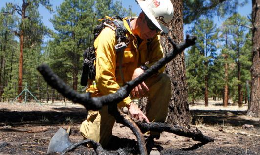
The "Fire Whisperers" - Fighting Fires With Computers And Intuition. Technology is giving firefighters a slight edge in their daily battle with the elements, as reported by the
New York Times: "
PHOENIX — As thousands of firefighters used hand tools and hoses to combat the wildfires torching vast stretches of the Southwest, Drew Smith stared into a computer screen at a command center near one of the fiercest blazes and tried to determine which way the flames would veer next. Some wildfires are mean. Some are wily. Some show exceptional endurance, or fierceness or moxie. The most difficult among them are assigned behavior analysts like Mr. Smith — fire whisperers, as it were — who act as psychologists delving into the blazes’ inner selves. “This fire is an exceptionally aggressive fire based on how large it has become and how fast it’s growing,” said Mr. Smith, now assigned to the Wallow Fire, which has become the biggest blaze in Arizona history after burning more than 527,000 acres in the eastern part of the state. Fire behaviorists work alongside meteorologists, given that the weather, especially wind patterns, plays a pivotal role in how a wildfire grows. The topography is also important because fires burn differently depending on whether they are going up a steep slope, across a valley or through a developed area. Then there are what firefighters call the fuels, which are the vegetation and other materials that give fires energy as they move along. With more than a dozen significant fires now burning through the Southwest, the fire whisperers are busy. At the sunrise briefings that wildland firefighters attend before they go off to the lines, a variety of status reports are offered on the day’s work ahead. None, though, is listened to as intently as that of the behaviorist, who uses computer modeling and intuition to try to predict how the fire will burn that day."
Record Heat Continues In The South...
...RECORD HIGH TEMPERATURE SET AT DALHART...
A RECORD HIGH TEMPERATURE OF 108 DEGREES WAS SET AT DALHART
ON JUNE 24. THIS BREAKS THE OLD RECORD OF 107 SET IN 1990.
...RECORD HIGH TEMPERATURE SET AT BORGER...
A RECORD HIGH TEMPERATURE OF 110 DEGREES WAS SET AT BORGER ON
JUNE 24. THIS BROKE THE PREVIOUS RECORD OF 107 DEGREES SET IN 1980.


* Amarillo, Texas also set a new record (109). Thanks to Chad Merrill at
Earth Networks for passing these along.
During Foul Weather At Travelers Championship, Attention Shifts To Forecaster. Yes, the poor weather guy (a local meteorologist, Wade Stettner, who works for Telvent, based in Bloomington) has REALLY been under the gun in recent days, trying to determine whether showers and (heavy) T-storms would invade Cromwell, Connecticut and force a delay in the major golf tournament. The
Hartford Courant has the details: "At the most intense moment in professional golf, the attention isn't on the leading player as he makes his final putt. It's on the
PGA Tour's on-site meteorologist. A lone contractor working in a nondescript, white trailer near the 10th tee at the
Travelers Championship at TPC River Highlands decides if lightning is flashing too close, or whether rain will drench the course in a few hours. The meteorologist offers the tournament director all the information to decide if plays stops, if a
CBS weekend broadcast comes to a halt, and if everyone should dash to the clubhouse or some other shelter.
The PGA Tour has had an on-site meteorologist since the early 1990s to protect the safety of players and spectators. One tragedy came on June 13, 1991, during the U.S. Open Tournament at Hazeltine National Golf Club in Chaska, Minn., when blue skies turned cloudy as a rainstorm moved in. Lightning struck a tree near the 16th hole, where six spectators were huddled. One of them was killed.
NASA To Fly Low Over Region For Air Quality Study: Ground-based ozone pollution is a growing concern, especially in metropolitan areas, where hydrocarbons, pollutants from industry and vehicles can combine with sunlight to create ozone, which can be harmful, especially to infants, the elderly, athletes who exert themselves outdoors, and anyone with heart or respiratory problems.
CBS Baltimore has the story: "
WASHINGTON (WJZ)—Don’t panic if you see large planes flying unusually low over Maryland roadways next week. It’s all part of a major plan by NASA to help study air pollution over major cities. Derek Valcourt explains where you’ll be seeing some of those low-flying planes. The study will focus on air pollution over many of Maryland’s major roads, from Baltimore’s beltway, to the 95 corridor, even over the Chesapeake Bay Bridge. This is no ordinary plane, it’s a specially fitted NASA aircraft designed with equipment to measure air pollution levels in flight. And starting next week the skies over Maryland will become a pollution detection playground for the plane and for NASA scientists. “The public I think is very interested in knowing where air pollution problems are the largest, and then they have the ability to make their own decisions about their own activities and times and places they would like to avoid,” said Dr. James Crawford, NASA atmospheric scientist. Maryland’s Department of Environment already has six pollution monitoring stations on the ground, but they’re spread out and only can tell you pollution levels in the immediate area."
"Anyone Caught Setting Off Fireworks Can Be Fined $500..." It is SO dry in the southern USA that fireworks have been banned in many communities. The reason? The risk of wildfires is off the scale.
AccuWeather reports: "
Arizona, central Florida, Louisiana and Utah have issued bans restricting the use of fireworks due to the extremely dry conditions caused by lack of rain. City officials from Shreveport and Bossier City, La., announced today that firework sales are banned through the end of June because of drought conditions in the area, according to Shreveporttimes.com. Firework sales in the past have been allowed for a 10- to 12-day period beginning about June 24 and continuing through July 5. The ban includes the Shreveport and Bossier city limits, rural Bossier Parish and Caddo Parish. City-sponsored fireworks will launch from a barge in Red River. However, the Bossier City Mayor announced Harrah's Louisiana Downs will not be permitted to host its Fourth of July show. According to Shreveportla.gov, 2011 has been the second driest year on record in Louisiana in 121 years. Officials cited public safety as the main factor in their decision. Officials announced in a press release that the ban will be reevaluated and there could be a ban lift without restrictions, with restrictions or the ban could remain in full force through the July 4th holiday. The decision will be based on the environmental conditions present at the end of June."
The 500-Year History Of Contact Lenses.
Gizmodo.com has the intriguing story (I had no idea!) "
Sticking glass in your eye is objectively a bad idea. And yet, in the 1800s, there were several highly educated individuals repeating that very action. If it weren't for them, 120 million people worldwide, myself included, wouldn't have this wonderfully engineered tool for clear vision, invisible to both wearer and admirer. The design of the contact lens can be traced back to Leonardo da Vinci who, with a bowl of water, kicked off the whole cringe-worthy history. In a manual published in 1509, da Vinci noted that when you stick your face in water, you see things differently. He wasn't really talking about correcting vision at this point, but manipulating the cornea's power is the idea behind the contact lens at its most basic. From there, it was a natural progression to assume that a tube filled with water smacked directly against the eyeball would do something cool. The problem: Right on top of the eye meant no blinking allowed. Other proposals included tubes held snug to the eyelids with a headband and capsules filled with "animal jelly." None were viable. None saw real-world testing."
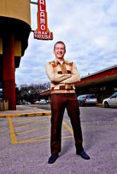
Don't Try Talking Or Texting In THIS Movie Theater! Here's an interesting story about a movie chain that has forbidden talking and texting (great idea) - they kicked out a patron, who proceeded to leave a flaming voicemail, which the movie chain is now using in a promotional campaign! Details from the New York Times: “At the Alamo Drafthouse, we have a simple rule: If you talk or text during a movie, we kick you out,” says screen text that begins the resulting video, which currently is being shown at theaters and was posted to YouTube on June 3. “What follows is an actual voice mail a customer left us after being kicked out.” In the message, the caller, who is not identified, asks if “you guys actually enjoy treating your customers like dirt?” although the last word is an expletive that is bleeped out. Her indignant and inadvertently humorous rant — at one point she seems to refer to the country as the “Magnited States of America” — concludes with “Thanks for taking my money, jerk,” with the last word, again, being an expletive. “You’re welcome!” responds text on the screen. “Thanks for not coming back to the Alamo, texter!” Two versions of the good-riddance video — one with the caller’s profanity audible and another with bleeps — drew a combined total of more than 4.4 million views on YouTube, and the video was featured on dozens of popular Web sites, including Gawker, Perez Hilton and Salon."
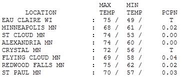
So-So Saturday. The forecast called for "partly sunny", and yes, the sun was out north/west of St. Cloud much of the day, where temperatures shot up into the 70s and people were fairly happy with the weather. South/east of MSP the weather was a different story: mostly cloudy most of the day. Yes, the forecast was a BUST, a tiny swirl of unusually cold air aloft (something the NAM model didn't even pick up) destabilized the atmosphere, sparking persistent clouds and a few light showers and sprinkles Where the sun came out, the mercury jumped to 74 at St. Cloud and Alexandria, 75 at Redwood Falls. With .02" of light shower MSP only had a high of 68, 70 at St. Paul.
Paul's Conservation Minnesota Outlook for the Twin Cities and all of Minnesota:
TODAY: Lukewarm sun. PM storms (best chance north/west MN). A few storms may become severe. Winds: SE 10-20. High: near 80
SUNDAY NIGHT: T-storms likely, locally heavy rain. Low: 63
MONDAY: Storms early, then slow PM clearing. High: 79
TUESDAY: Bright sun, a beautiful day. Low: 61. High: near 80
WEDNESDAY: Partly sunny, summer warmth. Low: 64. High: 85
THURSDAY: New word: "hot". Very humid. PM T-storm? Low: 70. High: 91
FRIDAY: Steamy, few T-storms north. Low: 73. High: near 90
SATURDAY: More sun, turning cooler & less humid. Low: 68. High: 84
Bordering on Surreal
The local National Weather Service summed it up best in a technical discussion of Saturday's odd pop-up showers on Doppler: "With the pattern we have been in...it just doesn't seem to take much to make it rain."
I feel like I'm trapped in a Steven Spielberg TV miniseries. Every day a new city joins the hit-list: Minot. Joplin. Tuscaloosa. Professional climate skeptics will tell you (with a straight face) that "this is all a coincidence". "It has nothing to do with the 90 million TONS of greenhouse gases belched into the sky every day, worldwide." No worries. It's just those alarmist climate scientists trying to get more funding! Right.
The Wunderblog's resident PhD expert, Jeff Masters writes, "It is highly improbable that the remarkable extreme weather events of 2010 & 2010 could have all happened in such a short period of time without some powerful climate-altering force at work. The best science we have right now maintains that human-caused emissions of heat-trapping gases like CO2 are the most likely cause of such a climate-altering force."
Good news: the sun stays out much of today; T-storms rumble in tonight and linger into early Monday. Steamy 90s return by Thursday & Friday.
Global Warming Is Based On Facts. Here's a post in the
Columbia Daily Tribune:
"
Another common statement of skeptics and deniers is climate always has changed. True enough. But, when core drillings of Greenland’s ice are examined, it turns out the presence of “greenhouse gases” has been relatively stable. Such events as volcanic eruptions, planetary drift, vegetation, sea level changes and even meteoric impacts go a long way toward explaining swings between cold and hot. The greenhouse effect is real, and the more carbon dioxide that is present in the upper atmosphere, the hotter it becomes down here. Glaciers are melting at unprecedented rates. Alaska has experienced average annual temperatures of 5 degrees above historical records, and it could well be that the long-sought Northwest Passage might become a reality. Ocean temperatures are increasing. Sea levels are rising. Storms are becoming more intense. Snowmelt and increased rainfall have led to major flooding. Arizona, New Mexico and Texas are burning. These are observable facts. What is at dispute is where global warming will occur first and will have the most impact. Clearly, some areas are more susceptible than others. The Southwest is a prime example: It already is hot and dry there; if it becomes hotter and drier, human habitation in such cities as Tucson, Phoenix and Albuquerque might become impossible. Alaska is also quite susceptible. Facts cannot be subjected to skepticism or denials. Repetition of a lie does not make it true. Those skeptical or in denial about the overall warming of the planet have succeeded in halting any and all efforts by “first world” nations to do anything about slowing down global warming. Their skepticism and denial imperil us all. Their victory will be short-lived. Whistling past the graveyard comes to mind. It is undeniable that the Earth is warming. This is not a matter of belief. This is based on fact."

"
My subscription to Rolling Stone Magazine ended roughly 30 years ago but this piece by Vice President Gore is worth reading. Here is its last paragraph. "The climate crisis, in reality, is a struggle for the soul of America. It is about whether or not we are still capable — given the ill health of our democracy and the current dominance of wealth over reason — of perceiving important and complex realities clearly enough to promote and protect the sustainable well-being of the many. What hangs in the balance is the future of civilization as we know it." Note the key word; "we". In a diverse society, what do "we" agree to? This dramatic paragraph emphasizes that we collectively have made the wrong carbon choices up to this point. But, "we" are a collection of individuals. How will individuals, as moms and dads, as consumers, choose to live our lives given the world we have unintentionally created by producing so much GHG emissions? Vice President Gore embraces a "collective" solution that "we" must band together. A more realistic vision is that people will differ with respect to their ability and willingness to "perceive important and complex realities". Those who do have these skills will be more likely to thrive in the tough days ahead and they are likely to make $ as entrepreneurs as they anticipate the others' future suffering."
Don't Wait Until It's Too Late. Here's a post from the
Sydney Morning Herald: "
New Chief Scientist Ian Chubb says the climate change debate is not about politics, but science. He explains why that science shows Australia needs to act. LAST Thursday marked my first month as Australia's Chief Scientist. During this time I have been refining my vision for this role and the role of science in Australia. In my recent address to the National Press Club, I outlined the importance of weight of scientific evidence and substance over noise of argument. While the focus of my office is the whole of science, I have inevitably been drawn into the noisy and uncivil climate change/climate science debate. Professor Ross Garnaut has summarised the state of climate science in his recent report. After several years of work he writes: ''The vast majority of those who have spent their professional lives seeking to understand climate and the impacts of human activities on it have no doubt that average temperatures on Earth are rising and the human-induced increases in greenhouse gases are making major contributions to these rises. They are supported in this by the learned academies of science (all disciplines) in all of the countries of scientific accomplishment.'' Science is not always perfect and interpretations of observations are not always unanimously agreed. But good science will increase probability through the weight of evidence from ''possible'' to ''beyond reasonable doubt''. Scientific knowledge at its best is constantly under review, critical analysis and is always evolving."
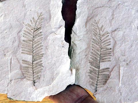
Fossils Show Proof Of Global Warming's Effect. Climate scientists rely on proxy data to determine climate states before the 1850s, when the "temperature record" began worldwide. That means ice core sample, tree rings, samples of sediment from lake bottom sediment, and fossils.
Todayonline.com has the story: "
NEW YORK - Sea levels are rising faster than at any point in the past 2,000 years because of the impact of global warming, scientists have found. Scientists used fossils to reconstruct sea levels over the past two millenia on the United States' Atlantic coast and found they are now rising faster than at any time in the past 2,100 years. By comparing the results to changes in global surface temperature, experts established a consistent link between higher temperatures and rising tides. Professor Benjamin Horton, director of the Sea Level Research Laboratory at Pennsylvania University, said: "Sea-level rise is a potentially disastrous outcome of climate change, as rising temperatures melt land-based ice and warm ocean waters." To accurately reconstruct sea levels, an international team of researchers examined layers of sediment from marshes in North Carolina to find remains of foraminifera, tiny plankton-like creatures. Because different species of foraminifera live at different depths, their remains indicated how deep the ocean was when the layer of sediment they were found in was laid down. The study, published in the Proceedings Of The National Academy Of Sciences, found that the sea level remained fairly stable between 200BC and 1,000AD. For 400 years, during a warm period known as the Medieval Climate Anomaly, sea levels rose by half a millimetre per year, followed by a period of stable or slightly declining sea levels during a cooler period known as the Little Ice Age, which lasted until the late 19th century.Since then the average rise in sea levels in North Carolina, where the study was based, has been higher than 2mm per year."
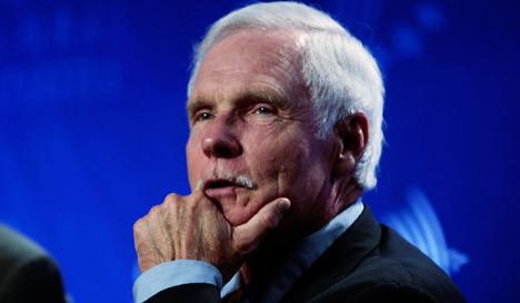
Ted Turner: Climate Change Humanity's Most Serious Problem. The Environment News Service reports: "SVALBARD, Norway, June 23, 2011 (ENS) - Today, on a warm day very close to the Arctic Circle, board members of the UN Foundation, including Founder and Chairman Ted Turner, got a close look at what effects climate change is having on the Arctic. After their annual Board of Directors meeting in Oslo, several directors traveled to Svalbard, the world's northernmost community. They journeyed up a fjord to the foot of a receding glacier with scientists from the Norwegian Polar Institute. Turner told reporters on a teleconference today, "They pointed out to us while looking at the glacier that it is receding every year due to global climate change. The temperature here at the high latitudes changes more rapidly than it does in the temperate zones." Based on observations to date, the scientists projected that this year the extent of Arctic sea ice will be smaller than it has ever been, even smaller than in the previous record low year of 2007. Among the board members visiting Svalbard was Gro Harlem Brundtland, a physician who served three terms as Prime Minister of Norway in the 1980s and '90s, and then became director general of the World Health Organization. As chair of the World Commission on Environment and Development in the 1980s, Brundtland created the concept of sustainable development and provided the momentum for the UN's 1992 Earth Summit. She now serves as a Special Envoy on Climate Change for UN Secretary-General Ban Ki-moon. Brundtland told reporters on the call that the scientists informed the group that ocean waters have heated up over the past decade at least one degree Celsius to a depth of 1,000 meters. "This is a dramatic change in a short period of time due to the changes humanity is causing by how we are acting," Brundtland said."
.
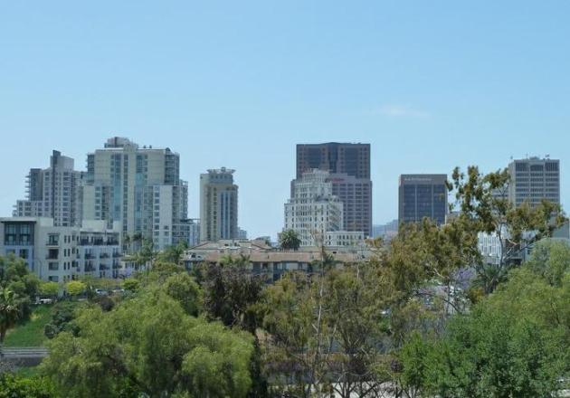
KPBS-TV has an update on efforts San Diego is making to reduce its carbon footprint: "
Don’t you love top-ten lists? San Diego will definitely like this one, which lists it as a top city in its devotion to fighting climate change. Yeah, I too was surprised to hear such a car-dependent place was so honored. But Triple Pundit, a sustainability website sponsored by Antioch University, placed San Diego number six in the nation. Their justification seemed to be the City of San Diego’s ambitious goals to increase the use of renewable energy and increase energy efficiency. Triple Pundit says: “San Diego intends to take advantage of its great climate and abundant sun by adding 50 megawatts of renewable energy by 2013 (much of it being new solar capacity) while achieving a 50 megawatt reduction in energy use through efficiency and demand side management measures.” And then there’s the trolley system, of course. Other cities in the top-ten list were more predictable. San Francisco got the top spot. Portland came in third. San Jose (not so predictable) was in 9th place."


No comments:
Post a Comment