TODAY: Sun returns, a much better day. PM T-storms sprout over WI. Winds: NE 5-10. High: 83
SUNDAY NIGHT: Partly cloudy, isolated T-storms near the Iowa border. Low: 64
MONDAY: More showers & T-storms move in. High: near 80
TUESDAY: Warm and humid. Potential for severe T-storm outbreak. Locally heavy rains Low: 68. High: 81
WEDNESDAY: Storm aloft lingers, more showers, some heavy. Turning cooler. Low: 62. High: 73
THURSDAY: Sun returns, ditch the umbrella. Low: 59. High: 78
FRIDAY: Plenty of sun, beautiful! Low: 61. High: 81
SATURDAY: Partly sunny, probably dry. Low: 63. High: 81

Stagnant Front. Yesterday's frontal boundary stalled over eastern Minnesota, acting as a magnet for heavy thunderstorms, some capable of 1-2" downpours and marble-size hail. That tormented front will get an eastward nudge today, enough dry air pushing across Minnesota for a partly sunny sky. Today should be a better, brighter, milder day.
"...And as you wait, watch, and worry, you choke on smoke, rub itching eyes, and sneeze fitfully. After a couple of days of that omnipresent smoke, almost everyone you meet has a headache. You know that when it is over, even if you're among the lucky ones whose homes still stand, you will witness and share in the suffering of neighbors and mourn the loss of cherished places, of shaded streams and flowered meadows, grand vistas, and the lost aroma of the deep woods."
- from an article at Salon, "Global Warming Is Burning Down The American West."
"...So far this year, 31,650 wildfires have burned more than 4 million acres of land - more than twice the area of Delaware - according to the National Interagency Coordination Center. That's up from 27,077 fires at the same time a year ago, which burned about a third as much acreage as this year."
- excerpt from an article in "Fire Engineering" below.
"These levels are just unbelievable for June," said Thomas, a longtime plow operator. "When we first started up here, you couldn't even make out an image of the road. So we're certainly making progress."
- snow plow operator at Glacier National Park, quoted in USA Today article below.
"There are few places that are safe in a violent tornado. Being in an underground storm shelter or a specially built in-home storm shelter is the only way to be absolutely safe."
- Dr. Greg Forbes from The Weather Channel, in a post on this year's terrible tornado toll. Article below.

"There will be a data gap. That data gap will have very serious consequences to our ability to do severe storm warnings, long-term weather forecasts, search and rescue and good weather forecasts."
- NOAA Administrator, in a USA Today article below.
Batting .500. Yesterday was a wash-out, yes, but the front shifts 75-100 miles to our east today, shoving most of the T-storms into Wisconsin, leaving us with enough sun for low 80s. Soak it up while you can.
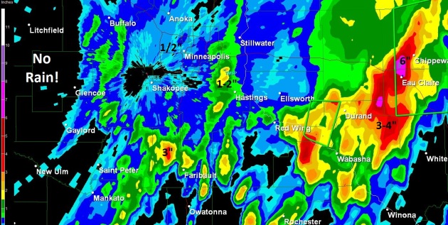
Saturday Gulley-Gushers. A wave of low pressure tracking northeastward along a temporarily stalled frontal boundary dropped significant rain on eastern Minnesota and much of Wisconsin yesterday. NWS Doppler estimates suggest nearly 3" near Northfield, some 1-2" amounts just south/east of St. Paul, and as much as 6" or more near Eau Claire, Wisconsin.
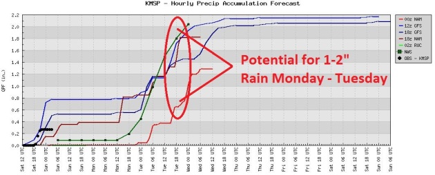
Make It Stop! After a brief break today, yet another storm pushes heavy showers and T-storms back into Minnesota Monday into Wednesday, a potential for some 1-2" amounts by midweek.
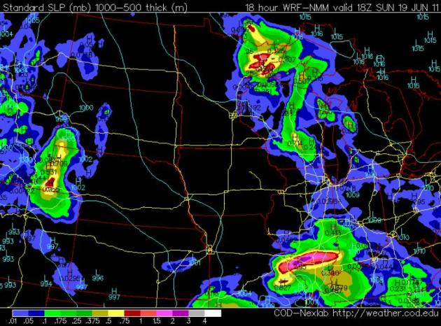
Today: Better Chance Of A Sunburn. Yesterday's annoying front will push east today; more heavy showers and T-storms over Wisconsin, but drier air should mean partly sunny skies for most of Minnesota. A stray PM shower can't be ruled out from St. Paul and Stillwater to Taylors Falls and Duluth. The farther west you go, the better the odds of a very respectable day, weatherwise.
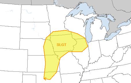
Tuesday Severe Threat. It's still early, but there may be sufficient instability, low-level moisture and instability for a few isolated severe storms Tuesday, especially over far southern Minnesota.
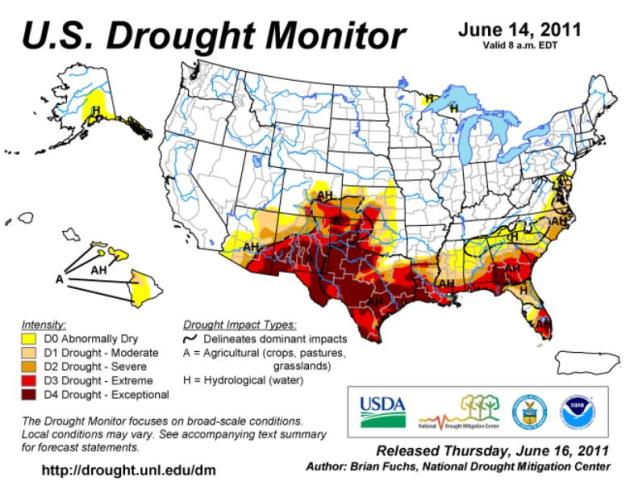
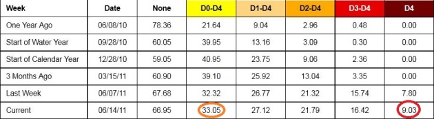
The Great Drought of 2011? It's early in the summer season to be tracking an expansive drought - heat and drought usually peaks in late summer, August and September. But here we are in mid June and roughly a third of the Lower 48 states are designated as "abnormally dry." Over 9% of the nation is in an "exceptional drought", an all-time record, according to NOAA. More details at NOAA's Drought Monitor.
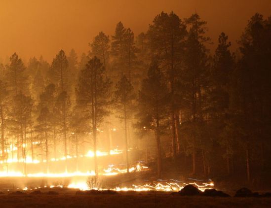
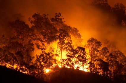
Wallow Fire Tops 500,000 Acres For First Time. The good news: Arizona's largest blaze is now 38% contained, but the weather has not been cooperating - winds gusting over 40 mph at times, making it much harder for the small army of firefighters on the scene. Azcentral.com has an update: "The largest wildfire in state history has eclipsed the 500,000-acres, but there's more good news than bad amid the latest developments, officials reported Saturday. While the fire has grown to 509,000 acres, U.S. Forest Service officials said containment of the blaze has risen to 38 percent. Another positive sign, they said, is the total personnel used to combat the fire has been decreasing as the containment numbers have gone up. The total number of personnel currently battling the wildfire is at 4,152 people."
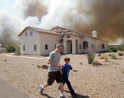
Arizona Firefighters World Amid "Perfect" Fire Conditions. No, the weather isn't cooperating with fire-fighting efforts, according to USA Today: "Firefighters battling a wildfire in southern Arizona are spending Saturday focusing on a string of canyons where tough terrain and dry fuels provide perfect conditions for a fire that has grown to 30 square miles and consumed 50 homes. In northeast Arizona and across the border into New Mexico, the gigantic Wallow fire topped a half million acres overnight. At 782 square miles, it's more than half the size of Rhode Island and has displaced myriad wildlife in the mountainous area. In the past few days, Wallow fire officials had to kill a 1-year-old bear that ripped apart eight tents and tried to enter some vehicles at a firefighters camp. "When a fire burns this much country, those guys are going to be hungry and they are going to go out looking for food," said Dugger Hughes, commander for the Southwest Area Incident Management Team."
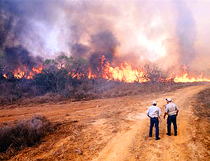
Fire Hazard: A Brushfire Bonanza. Some remarkable statistics from Fire Engineering: "The fires searing parts of the American West are an eerie echo of the past, a frightening reminder of a once terrible danger that had been held largely at bay for decades. The number of large wildfires has been rising for roughly the past 25 years, and they are lasting longer amid fire seasons that also last longer. Is it global warming? Experts won't say that, pointing instead to a variety of factors ranging from local weather to insect infestations to more people living and camping out in the woods. The Arizona fire, with almost half a million acres destroyed, makes it one of the largest since statehood in 1912. A related blaze is under way in New Mexico, another fire has forced people to evacuate parts of Colorado, and the National Weather Service has issued "red flag" warnings - indicating conditions favourable to wildfires for parts of Texas, Florida and Alabama. So far this year, 31,650 wildfires have burned more than 4 million acres of land - more than twice the area of Delaware - according to the National Interagency Coordination Center. That's up from 27,077 fires at the same time a year ago, which burned about a third as much acreage as this year. The number of large fires began to grow in the mid-1980s, according to research by Anthony Westerling of the University of California, Merced. His paper published in the journal Science in 2006 documented the number, size and frequency of fires."
Skiing In July? Winter snowfall ran 2 to 7 times normal across much of the west, and an unusually chilly/stormy spring has prevented most of that snow from melting. Good news for skiers - bad news for anyone living downstream. The Sacramento River Valley may be threatened with severe flooding in the weeks ahead. Here's an incredible post from unofficialnetworks.com: "We all know that Tahoe had a banner season in 2010/11. But, how epic was it? How big were the snow totals at ski resorts in Lake Tahoe?
We were curious, too so we got the numbers from www.TahoeWeatherDiscussion.com and put ‘em up here for all to see.All the ski resorts below have snow totals on their websites, except for Alpine, Homewood, Boreal, & Diamond Peak. In those cases TahoeWeatherForecast.com kept a tally of their numbers and added it up for us. If you haven’t checked out this website yet, you need to, it’s the ultimate for Tahoe Weather. Photo above courtesy of Andrew Gauthier.
Alpine Meadows – 852″
Squaw Valley – 810”
Boreal – 803″
Sierra-at-Tahoe – 763″
Sugar Bowl - 750″
Kirkwood – 748″
Northstar – 666” (the mark of the Beast)
Homewood – 650″
Mt. Rose – 547″
Heavenly – 528″
Diamond Peak – 315”
* The following Lake Tahoe Area ski resorts will be open for the 4th of July: Squaw Valley, Alpine Meadows, Sugar Bowl (only open 4th of July and only to passholders) and Kirkwood. Remarkable.

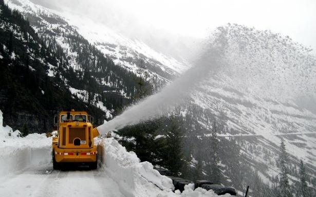
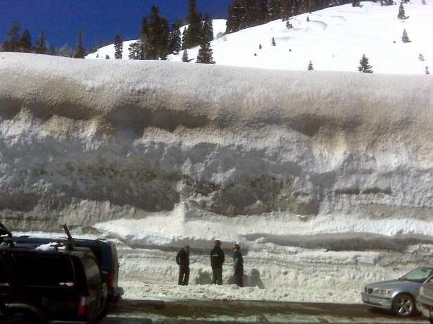
"Incredible" Amounts Of Snow At Glacier National Park. Evidence that global warming is a hoax? Don't think so. Climate models have been predicting heavier rain (and snow) for the last 30 years, and this past winter was an extreme example of loading the dice; the 4% increase in atmospheric water vapor MAY be a factor in not only the record flooding on the Mississippi and Missouri Rivers, but also the record snow across much of the western USA. More details from missoulian.com: "WEST GLACIER - A twisting helix of snow arcs high into the sky above Glacier National Park and briefly obscures the dark features of iconic mountain peaks before scattering its frozen contents into the great white abyss below. Amid the swirling tempest, a fleet of safety-yellow rotary plows, excavators and bulldozers - cast in sharp relief against the pale, towering drifts - hew and chew their way through a wall of snow on the famed Going-to-the-Sun Road. The half-million dollar machines sink spiked cleats into sheer vertical banks, seeking purchase on icy roadside masses that are an anomaly in mid-June. The machine that Carl Thomas operates, the one creating a mini-cyclone high above the McDonald Creek Valley, is capable of clearing 4,000 tons of snow an hour. In this year of dense snowpack, the plow can't forge ahead fast enough. "These levels are just unbelievable for June," said Thomas, a longtime plow operator. "When we first started up here, you couldn't even make out an image of the road. So we're certainly making progress."
* Much of that melting snowpack is now flowing into the Missouri River Basin:
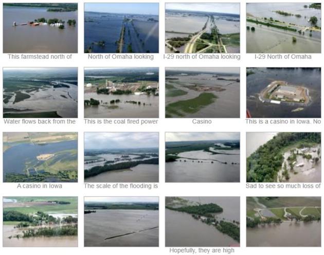
The Great Missouri River Flood of '11. Thanks to photojournalist Larry Geiger, who has an amazing library of photographs in a Picassa library, a collection of photos that really captures the mind-numbing scope of flooding on the Missouri River: "I took these pictures of the Missouri River Flood of 2011 and I would like to share them with anyone interested or with anyone that would like to reprint them. The area I cover is from Gavin's Point Dam, South Dakota to Hamburg, Iowa. If you feel they were worth something please donate to the Red Cross or other flood relief organization that will help the people affected by this disaster."
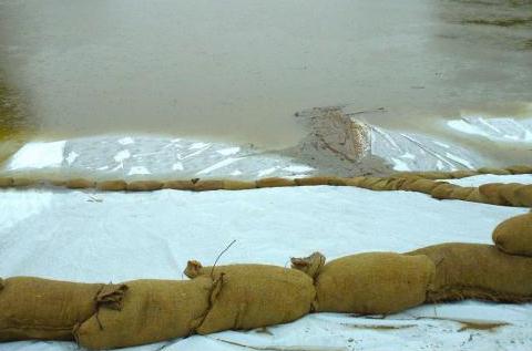
A Soggy Summer Awaits Along The Missouri River. Yes, this is unusual, a measure of how extreme western snowfall was, coupled with unusually heavy spring rains over the Northern Plains. Missouri River flooding is typical from March into early May, but this year flooding may extend into September, as reported by USA Today: "KANSAS CITY, Mo. (AP) — It isn't so much the amount of water churning its way down the Missouri River that has people along the nation's longest waterway on edge. It's how long all that water will stick around. The annual "spring rise" on the Missouri will last deep into this soggy summer, as a torrent of early season rains and winter snowpack flows through wide-open gates of South Dakota's Gavins Point Dam upriver and toward the confluence with the Mississippi River. The Missouri might start to crest soon, but it won't start to fall until August or later. That constant pressure on the network of levees that protect farmland, roads, small towns and big cities from a river running well outside its banks is what worries folks downriver most as the high water heads south toward Kansas City and east toward St. Louis. "The length of the flood will test levees like they've never been tested before," Missouri Gov. Jay Nixon said. "You're going to see levees which in essence may be tall enough, but not strong enough." That isn't the only worry as the summer of 2011 shapes up as the worst since 1993, when a Missouri River swollen by weeks of rain over the north-central United States led to flooding that killed 32 people, damaged an estimated 100,000 homes and caused $15 billion in damage."
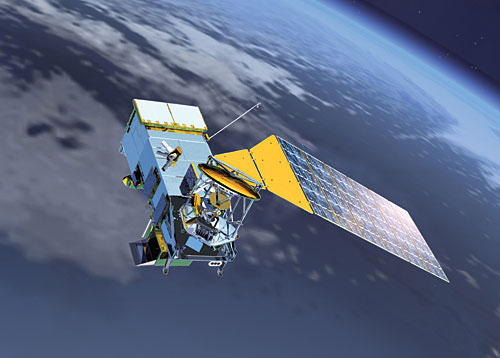
Looming Gap In Weather Satellites Threatens Forecasting. Yes, we have a severe deficit problem in this country, but Congress is delaying funding on a new (polar-orbiting) weather satellite, necessary for high-resolution imagery, mapping hurricanes, tornadic thunderstorms, extent of flooding, wildfires. Orbiting the planet at an altitude of 517 miles (vs the 22,300 mile altitude of the "GOES" geosynchronous satellites) they map the entire planet from low-orbit twice daily. USA Today has details on a possible gap in satellite coverage: "WASHINGTON — Congressional budget cutting will delay the launch of a key weather satellite and hinder tracking of killer hurricanes, tornadoes and other severe weather, officials warn. The satellite, which had been scheduled to launch in 2016, will be postponed 18 months because of spending cuts and delays. The threat during that gap is that National Weather Service forecasts will become fuzzier, with the paths of hurricanes and tornadoes even less predictable. With more budget cuts looming, further delays are possible — something President Barack Obama alluded to this week. In an interview with NBC's "Today" show Tuesday, the president acknowledged the need to reduce federal debt but said "really important" priorities include ensuring "government functions like food safety or weather satellites are still up there." The satellite at stake is part of the National Oceanic and Atmospheric Administration's Joint Polar Satellite System. The program is crucial for weather forecasting because polar satellites circle Earth every 90 minutes, scanning the entire planet twice every day. By flying only 517 miles above the surface, polar satellites give a sharper view than stationary satellites that float 22,300 miles above a specific place."
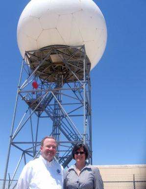
The Power of "Dual Polarization" Doppler Radar. Many local TV stations are upgrading their live Dopplers to "Dual-Pol", an enhancement that scans a 3-D volume around the radar site vertically, as well as horizontally. This should result in better forecasts of hail size and precipitation amounts; hopefully more accurate flood warnings. The National Weather Service is also upgrading the network of 150 Dopplers across the USA. Arizona's East Valley Tribune has the story: "The National Weather Service now has a more precise eye in the sky. Officials from the National Weather Service and National Oceanic Atmospheric Administration unveiled an upgrade of its Doppler weather radar at Mesa's Phoenix-Mesa Gateway Airport this week. The dual polarization radar better pinpoints storms, calculates the amount and size of rainfall, provides more timely flash flood warnings and monitors dust storms. The upgraded radar is an enhancement to the Doppler radar system in place and adds another dimension to tracking the weather: Doppler was only scanning the sky horizontally, but now with the dual polarization, it also will scan the sky vertically. Its effectiveness will be reviewed in the months ahead before 131 dual polarization systems are deployed across the nation by mid-2013 at a cost of $225,000 per unit, according to Vickie Nadolski, director for the National Weather Service's Western Region. The project totals $29.2 million. "This makes us more aware of what's going on in the atmosphere," Nadolski said on Wednesday. Technology has come a long way in many aspects and this will help us to better pinpoint areas of where severe weather can happen. The investment is into the millions, but we're hoping for huge returns."
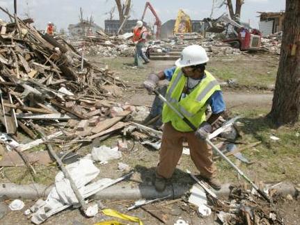
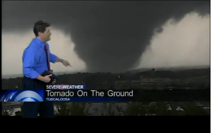
Death Toll From Joplin Tornado Rises To 154. The grim news from AP and USA Today: "JOPLIN, Missouri (AP) — The death toll in Joplin has risen to 154 people with the death of a man injured in last month's tornado. Joplin city spokeswoman Lynn Onstot identified the victim as James Cookerly. She says she doesn't have details about where or when he died. Onstot says her information came from the city's police department. Police did not immediately return a phone message left Saturday by The Associated Press. The death total from the May 22 tornado had stood at 153 since Monday, when city officials reported two more fatalities. It is the nation's deadliest single tornado in more than six decades."
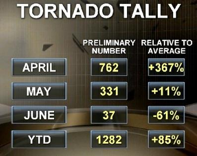
A Terrible Tornado Year. The Weather Channel's Dr. Greg Forbes (a fellow Penn State meteorology grad) has a thoughtful post about this year's tornado toll; lessons to be learned. I couldn't agree more: "What has been most shocking to me is that 2011 has brought so many tornado deaths in this era of excellent Doppler radar-based tornado warnings, excellent advance forecasts, and multiple ways of communicating/receiving tornado warnings and weather forecasts. Yet the death tolls are like what took place before there was any weather radar; before there were any tornado warnings issued by the National Weather Service; before there were any computers! I never thought I ?d see these death tolls nowadays.
I suppose that the message from the deadly 2011 tornadoes is that warnings aren't enough when the tornadoes are violent with long and wide paths. That combination of path width and length gives so much area having winds in excess of 100 mph that too many homes get hit and destroyed. And when the path hits communities, the toll is high. Urban sprawl has increased the target areas of these metropolitan "bulls-eyes." The safety rules of going to the lowest, innermost location in your home raise your odds of surviving, but aren't absolute guarantees. There are few places that are safe in a violent tornado. Being in an underground storm shelter or a specially built in-home storm shelter is the only way to be absolutely safe."
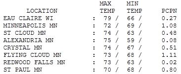
Soggy Saturday. It's rare to get a total wash-out in June, when precipitation is "showery", not the steady, widespread rains that normally fall in spring and autumn. But if a front stalls - all bets are off. T-storms kept redeveloping along a stalled frontal boundary, resulting in some excessive rainfall amounts: 1.08" in the Twin Cities (1.11" at Eden Prairie). Meanwhile St. Cloud picked up .48" rain, only .02" at Redwood Falls, where it was a pretty nice Saturday.

Friday Evening: Padres, Joe Mauer, and Mega-Bugs. I was at the Twins game Friday evening, watched in wonder as the Twins beat San Diego, 6-5. By the 7th inning the air was thick with huge (aggressive) bugs - they were getting into people's hair, crawling down backs - a few people were screaming in the stands, jumping up and down, trying to rid themselves of these crawling little pests. Has it always been this bad at Target Field? Those bright lights attract some strange-looking creatures!
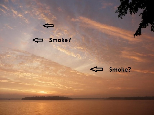
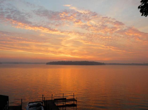
A Surreal Sunset. Did you see the sunset yesterday? After a series of window-rattling, gulley-gushing T-storms skies cleared just in time for a picture-postcard-perfect sunset. But I noticed a few wisps of white. Haze? I don't think so. I can't confirm this - but I suspect this is smoke from wildfires burning across Arizona and New Mexico, being swept northeastward by jet stream winds.

The "Grand Bargain"
The deal works like this: survive a Minnesota winter; muddle through, scrape, shovel, groan & shiver 'til it hurts - your reward will be a magical summer of fishing, splashing, hiking & biking fun, in a watery playground unlike anything on Earth. But when summer does (finally) arrive & T-storms sprout on fleeting, precious weekends, Minnesotans lose their stoic sense of humor. "This isn't fair!"
No, it's not. But I ask my family & friends to try and keep a little perspective. A drought roughly the size of New England is gripping the Deep South; "exceptional drought" covering 9% of America, an all-time record, according to NOAA. Droughts usually peak in August; it's early in the summer to be tracking historic levels of drought. Wildfires are forcing chaotic evacuations from Arizona to Florida. Meanwhile, a record snowpack is melting over the Northern Rockies; 65" of "meltwater" in the 100+" snow at Glacier National Park; water now flooding the Missouri River. It could be worse.
The stalled front responsible for Saturday downpours gets an eastward nudge: storms over Wisconsin but some sun for Minnesota today! Severe T-storms are possible by Tuesday; soggy into Thursday. Ugh.
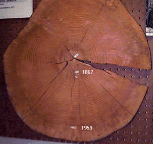
Tree Rings Record Changing Snowpack, Research Finds. A story from the Billings Gazette: "Greg Pederson sees the recent publication of his research on snowpack declines in the West as a prime opportunity to reiterate the difference between climate and weather in this record-setting wet spring. Pederson, an ecologist with the U.S. Geological Survey in Bozeman, was the lead author of a paper published last week in Science magazine detailing the decline in snowpack observed by examining tree rings from the watersheds of the Columbia, Missouri and Colorado river basins dating back more than 800 years. His findings: Not only has snowpack declined compared to past climate fluctuations, but there's also been a "decoupling" of precipitation in the Colorado River basin and that of the Northern Rockies. What this means is the tendency for the north to have high snowpacks when the south is experiencing meager ones, and vice versa, has shifted to declining snowpack across the West. The long-term implications of reduced snowpack in the West, which provides water to an estimated 70 million people in just the three drainages Pederson studied, portends huge challenges for water managers in the future, he said."
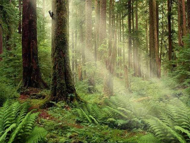
Study: Trees Not Cure For Global Warming. The Regina Leader-Post has the story: "Planting trees may help appease travellers' guilt about pumping carbon into the atmosphere. But new research suggests it will do little to cool the planet, especially when trees are planted in Canada and other northern countries, says climatologist Alvaro Montenegro, at St. Francis Xavier University in Nova Scotia. "There is no magic bullet" for global warming, says Montenegro, "and trees are certainly not going to be providing it." He assessed the impact of replanting forests on crop and marginal lands with Environment Canada researcher Vivek Arora. Their study, published Sunday in Nature Geoscience, concludes "afforestation is not a substitute for reduced greenhouse-gas emissions." The United Nations, environmental groups and carbon-offset companies are invested heavily in the idea that planting trees will help slow climate change and global warming. International authorities have long described "afforestation" as a key climate-change mitigation strategy. But the study says the benefits of tree planting are "marginal" when it comes to stopping the planet from overheating."
No comments:
Post a Comment