TODAY: Isolated shower or sprinkle early, then clouds give way to partly sunny skies, a cool breeze. Winds: N 10-15. High: 67 (slowly rising barometer).
SATURDAY NIGHT: Partial clearing, still unseasonably cool. Low: 49
SUNDAY: Much better. Sunny & pleasantly mild with low humidity. Winds: SE 10-15. High: 74 (slowly falling barometer).
MONDAY: Partly sunny, showers north. Low: 57. High: 78
TUESDAY: Showers, T-storms, some heavy. Low: 64. High: 81
WEDNESDAY: Soggy start, showers taper off. Low: 63. High: near 80.
THURSDAY: Break in the stormy action. Warm sun, very nice. Low: 63. High: 83
FRIDAY: Heavy showers and T-storms. Low: 64. High: 82

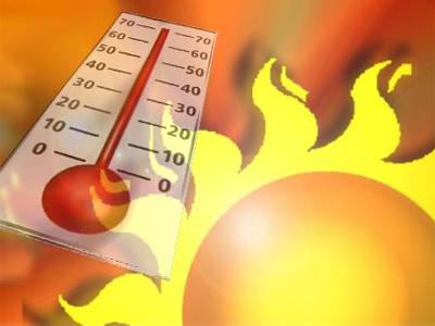
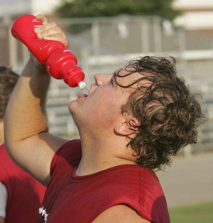
62 F. high in the Twin Cities on Friday, 16 degrees cooler than average.
Saturday: Clouds should give way to partly sunny skies: highs holding in the 60s, some 10-15 degrees cooler than average. Winds will blow from the north at 10-15 mph - a bit cool for the lake.
Sunday: still looks like the better day for outdoor plans, more sun, highs in the 70-75 range with a southeast breeze at 10-20 mph.
+ 8.2 F. So far temperatures in June are running a little more than 8 degrees above average in the Twin Cities.
"Summer Light" I see a few (low) 80s next week, but no more extreme heat is shaping up through the third week of June.
____________________________________________________
Chicago: midweek temperature plunge, largest in 23 years - a 45 degree drop, from 103 F. to 54 F.
Chicago: over 425 flights cancelled Thursday because of severe storms. 59,000 people suffered power outages.
Des Moines: June 9 was the 5th wettest day in their history, 4.53" rain fell. Source: dsmweather.com.
2 Interstates now shut down because of flood waters. Details below.
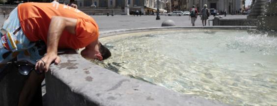
Atlantic City: 100 on Thursday, the earliest 100-degree day in the city's history.
Nashville: 14 days/row above 90. This could be the hottest CMA (Country Music Awards) in history.
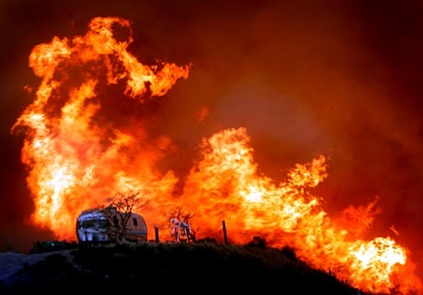
Miami: wildfire in west Miami-Dade County has grown to 50,000 acres.
Houston: no significant rain since last fall. 12.84" rain since last October, roughly 20" less rain than average.
"Exceptional Drought": spreading into much of Georgia.
Poor Air Quality reported across much of the southeast. "Code Orange" conditions (unhealthy for sensitive groups) predicted for Atlanta, Birmingham, Charlotte, Raleigh, Chattanooga, Knoxville, Norfolk and Richmond due to stagnant conditions.
Montana: many towns have seen a "top 5 wettest period" from May through June 10.
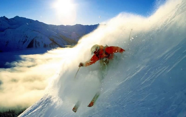
Rockies: snow packs over 100" on many of the mountain ranges.
Ski Resorts: are still open, others hope to open up for the 4th of July.
"According to our projections, large areas of the globe are likely to warm up so quickly that, by the middle of this century, even the coolest summers will be hotter than the hottest summers of the past 50 years." - Washington Post article below.
"From 1960, when the center's tally begins, through 2010, wildfires throughout the US burned an average of 4.2 million acres a year. Between 2000 and 2010, however, the average rose to 6.6 million acres a year. Six of the last 11 years saw from 7 million to nearly 10 million acres burned. Between 1960 and 2000, only two years reached the 6-million-acre mark." - Christian Science Monitor article below.
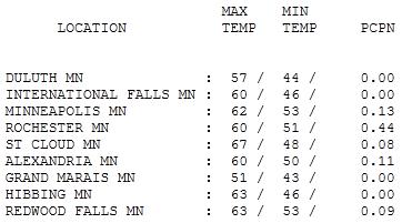
Springy Relapse. Under a canopy of gray it felt more like late April or early May out there yesterday, temperatures 10-20 degrees cooler than average for June 10. HIghs ranged from 51 at Grand Marais (good grief!) to 57 Duluth, 62 in the Twin Cities and 67 at St. Cloud (where the sun was able to peek through for a couple hours). .44" rain doused Rochester.
Today: Getting Better. A passing shower or sprinkle can't be ruled out, especially early (over far southern and southeastern Minnesota), but today should be basically dry, with clouds giving way to intervals of sun, a cool north breeze averaging 10 mph, with a few higher gusts. Temperatures will be on the cool side, still nearly 10 degrees cooler than average. Whatever happened to "average"?
Sunday: Better Day. The sun should be out most of Sunday, although clouds may increase over far western Minnesota late in the day. A weak bubble of high pressure holds on long enough for blue sky, a southeast breeze at 10-15, and a slowly falling barometer - highs in the low to mid 70s.
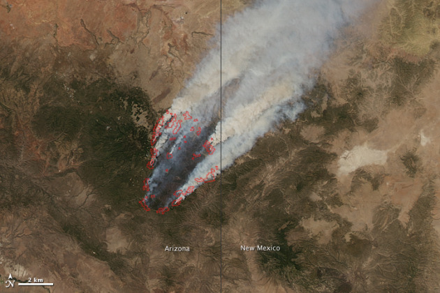
Wallow Fire Update: approximately 5% of the massive Arizona blaze has been contained - it's already blackened 408,960 acres, an increase of 72,960 acres from Thursday. Image above courtesy of NASA's Earth Observatory.
Latest info from: http://inciweb.org/incident/2262/
Number of Personnel: Approximately 3,137.
Location: south and west of Alpine, Arizona (250 miles east of Phoenix)
Including 19 hotshot crews and 45 hand crews.
Cause: Authorities suspect fire may have started from an unattended campfire.
Equipment: 17 dozers, 221 engines, 66 watertenders.
Size: 408,887 acres based on last night's infrared data.
Aircraft: 14 helicopters.
Percent Contained: 5%
Injuries to Date: 3.
Residences: 5,242 threatened; 29 destroyed 5 damaged.
Structures: 24 destroyed.
Other: 1 truck destroyed.
*The Wallow fire, based on the most recent information available late yesterday, was about 15 miles (24 kilometers) from a high-voltage transmission line that delivers 40 percent of the power used by its customers, Teresa Souza, a company spokeswoman, said today. The line delivers power from Palo Verde, the largest U.S. nuclear plant, to 371,000 homes and businesses in western Texas and southeastern New Mexico. Tucson Electric and El Paso Electric have also warned about rolling blackouts if the blaze knocks out their two large transmission lines.
* Wildfire has displaced some 10,000 people.
* The latest aerial infrared images of the fire showed it had not grown in size during the past 24 hours
* Winds have died down to less than 25 mph, allowing firefighters to make progress.
* Fire has consumed 603 sq. miles of timber since May 30th.
* The state's largest wildfire on record, the Rodeo-Chediski fire in eastern Arizona, blackened almost 469,000 acres in 2002 before it was snuffed.
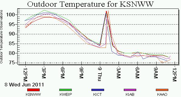
Heat "Burst" In Wichita. In the span of a few minutes around midnight temperatures in Wichita soared 15-20 degrees. It was the result of a "heat burst", a rare phenomenon, triggered by violent thunderstorm downdrafts. In some instances these sudden downdrafts can compress air, which results in rapid warming (much like pumping air into a tire heats it up). More details from the AP: "WICHITA, Kan. - An unusual weather pattern caused temperatures in Wichita, Kan., to soar nearly 20 degrees in 20 minutes even though the sun had long gone down. National Weather Service meteorologist Stephanie Dunten says the heat burst hiked temperatures from 85 to 102 degrees in 20 minutes, beginning at 12:22 a.m. Thursday. She says a pocket of air in the upper atmosphere collapsed, and when it hit the ground it sent winds of more than 50 mph through parts of the city. The Wichita Eagle says that during a heat burst, rain falling from higher elevations cools air beneath it as it evaporates. The cooler air then descends quickly to the surface. As it falls, it is compressed and warms dramatically."
* temperature trend above courtesy of KSN-TV and Earth Networks, formerly WeatherBug.
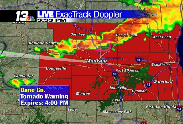
Weather Service Confirms Dane County Tornado. Channel3000.com has the story: "The National Weather Service has confirmed an EF1 tornado occurred Wednesday evening in Dane County, and it caused the worst damage in Verona. The tornado toppled trees and tore down power lines along a 15-mile stretch between Verona and McFarland."The tree damage is interesting," said Rusty Kapela, a storm surveyor from the National Weather Service. "You're looking at some healthy trees that have been uprooted or broken into pieces."Verona resident Bob LaPlant said he feels lucky there wasn't more damage than the few trees down on his property, considering that his house is surrounded by hundreds of trees."It could be a lot worse with all the trees we had here," LaPlant said.A few miles away, Dan Hawk and his family weren't as lucky."The skies got dark and winds were starting picking up," Hawk said. "The next thing you know, the branch came crashing down."That tree came crashing down on the family minivan, which is a complete loss. Hawk said he knew a storm was coming, but he really had no warning."The sirens actually came on about four to five minutes after the tree and all the wind came through," he said. "So, it was a pretty intense night."Hawk said the destruction left behind is replaceable, including his mangled minivan. Considering it was a tornado, he said he's just glad no one was hurt." (Doppler radar image courtesy of WREX-TV).
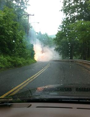
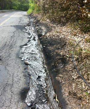
Pavement-Melting Storms. A friend of WeatherNation meteorologist Jason Parkin lives in Connecticut. On Thursday severe thunderstorms brought down a powerline, which resulted in the damage above. Stating the obvious: do not go near a sparking high-tension line after a storm, unless you want to get Nearer My God To Thee: "Check these out. Crazy storm here last evening - knocked a tree down on a powerline and cut power....huge electrical fire melted the pavement."
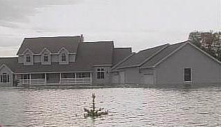
Million Dollar Homes Flooded In Ft. Pierce. The Missouri River is still out of its banks, and is expected to remain well above flood stage into September. Flooding is being reported in Sioux City, Iowa; levees are being rushed to completion to protect area homes. Over 260 miles of the Missouri River has been closed to boaters. This is turning into the wettest season for the Missouri River basin in the last 113 seasons. The Army Corp of Engineers is managing a series of swollen reservoirs in Montana, as well as North and South Dakota; with record snowpack in the Rockies melting rapidly the situation may get worse before it improves. KSFY-TV has more details on the flooding in Ft. Pierce: "The only way to get to Dr. Rodney Vizcarra's driveway now is by boat. His Fort Pierre dream home is underwater. Something he was told was impossible when he built the home 18 years ago. "We consulted with the corp before we built the house and everyone laughed and said there's no problem building here," said Dr. Vizcarra. But clearly there have been flooding problems. In fact he says there's been two. Back in the 1997 flood he had sandbags around his home for five months. After years of negotiating with the Army Corps of Engineers he says it was decided he would flood proof his home. That meant a remodel which including filling in his basement and meeting other army corps requirements. "They told me I was good to go and I should never see flooding in my lifetime." But here we are surrounded by damage far worse than what happened in 97. And Rodney says unlike in 97 this one came with absolutely no warning. "This time unfortunately it was rumors." He says no one was telling the neighborhood this kind of devastation was possible."
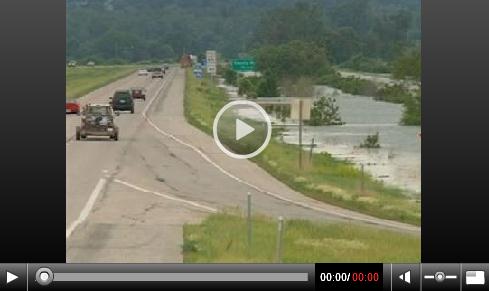
Flood Summary: Two Interstates Now Shut Down. KCCI-TV has the story: "AMES, Iowa -- A second interstate in western Iowa has been closed Friday due to flooding along the Missouri River.
The Iowa Department of Transportation is reporting that rising flood waters have forced the closure of both the west- and eastbound lanes of Interstate 680 between Iowa and Nebraska. I-680 is closed from the I-29/680 interchange (exit 61 near Crescent) in Iowa to North 30th Street in Omaha (exit 13).The Iowa detour route for interstate roadways closed in this area is: I-680 east from the I-29/I-680 interchange near Loveland to I-80, and then take I-80 southwest to Council Bluffs.The Iowa DOT said Interstate 29 north of Council Bluffs is closed Friday after the Missouri River overtook the road faster than expected on Thursday night.The Iowa Homeland Security and Emergency Management Division officially activated the State Emergency Operations Center Friday morning in response to flooding in western Iowa."
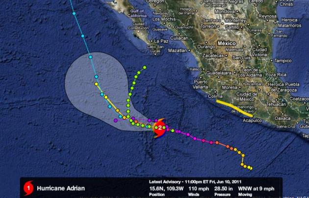
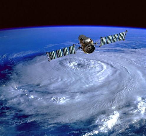
Hurricane Adrian Update. At one point "Adrian" was a Category 4 hurricane with 140 mph winds. The core of the storm is passing over cooler ocean water - the hurricane has weakened rapidly, now a Category 1 storm with sustained winds closer to 80 mph - a threat to cruise ships and slow-moving whales off the west coast of Mexico. Graphic and model plot courtesy of Ham Weather and NHC, the National Hurricane Center.
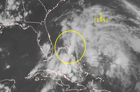
Tropical Disturbance. NHC is keeping a watchful eye on a tropical wave east of the Bahamas. There's probably too much wind shear for this storm to organize into Tropical Storm Arlene, but it bears watching nonetheless. More from NHC:
"A LOW PRESSURE SYSTEM LOCATED OVER THE NORTHWESTERN BAHAMAS IS
PRODUCING A LARGE AREA OF CLOUDINESS AND THUNDERSTORMS PRIMARILY
OVER THE THE FLORIDA STRAITS...THE NORTHWESTERN AND CENTRAL
BAHAMAS...AND THE ADJACENT ATLANTIC WATERS. THE LOW IS INTERACTING
WITH A BROAD UPPER-LEVEL TROUGH LOCATED OVER THE GULF OF MEXICO...
AND UPPER-LEVEL WINDS ARE CURRENTLY UNFAVORABLE FOR SIGNIFICANT
DEVELOPMENT TO OCCUR. THERE IS A LOW CHANCE...10 PERCENT...OF THIS
SYSTEM BECOMING A TROPICAL OR SUBTROPICAL CYCLONE DURING THE NEXT
48 HOURS AS IT MOVES SLOWLY NORTHWARD OR NORTH-NORTHEASTWARD."
Hurricane Harvey? Hurricane Names For 2011. June 1 was the official start of hurricane season. Here, in alphabetical order, are the names. I have a strong hunch we're about to see a more active season than last year, when there were NO direct hurricane strikes on the USA, in spite of the third busiest hurricane season in the Atlantic on record: Arlene, Bret, Cindy, Don, Emily, Franklin, Gert, Harvey, Irene, Jose, Katia, Lee, Maria, Nate, Ophelia, Philippe, Rina, Sean, Tammy, Vince and Whitney.
So Long La Nina. According to NOAA La Nina (strong cooling of equatorial Pacific Ocean water) is now a thing of the past. As of late May we're now in an "ENSO-neutral" pattern, with water temperatures pretty close to where they should be. Who cares? La Nina may have played a role in our excessive snow (86.6" - just in case you forgot), our late spring, major flooding and record-setting tornado season. If we continue to see unusual (and sustained) levels of extreme weather going forward we won't be able to pin it on anomalies in the Pacific. More from NOAA:
"Synopsis: ENSO-neutral conditions have developed and are expected to continue at least through the Northern Hemisphere summer 2011. A transition from La Niña to ENSO-neutral conditions occurred during May 2011 as indicated by generally small sea surface temperature (SST) anomalies across the equatorial Pacific Ocean east of the Date Line (Fig. 1). The latest weekly Niño index values (Fig. 2) showed near-average SSTs in the central and east-central equatorial Pacific."
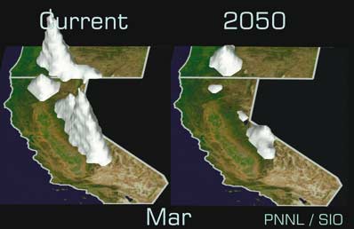
Snowpack Study Indicates Drier Future. This winter has been a welcome aberration out west: record snows from the Rockies westward to the Sierra Nevada and Cascade Range. But the larger trends are worrisome for residents of the west, concerned about sufficient water supplies in a slowly warming planet. USA Today has the story: "Northern Rocky Mountain snowpack levels over the past five decades are sharply down compared with the past eight centuries, federal researchers reported Thursday. Despite this year's wet weather replenishing mountain snow, the finding suggests drier times are ahead for the West. In particular, the northern Rockies' snowpack feeds the Columbia, Colorado and Missouri rivers, now the primary water sources for 70 million people. The historical snowpack reconstruction results, dating to the year 1200 and released by the journal Science, suggest that global warming has broken the normal seesaw pattern of snowpack in the region, in which a down year in the northern Rockies will be offset by a higher snow year in the southern Rockies. Overall, the average yearly snowpack across the northern Rockies — directly known from snow records to have dropped 30% to 60% in the past 50 years — has fallen more sharply in that time than for any period in the past 800 years, the study shows. "Temperature is the driver here," says study lead author Greg Pederson of the U.S. Geological Survey's Northern Rocky Mountain Science Center in Bozeman, Mont. "It doesn't take a rocket scientist to know that if temperatures get warmer, snow and ice melt sooner."
* Another article on long-term water trends out west from Colorado Spring's gazette.com.
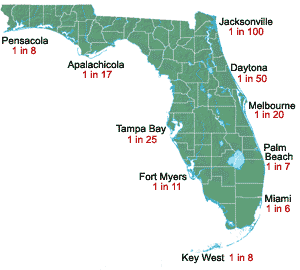
What Newcomers To Florida Can Expect During Hurricane Season. Richard White at TCPalm.com has some advice for people living in Florida (information to keep in mind if your travels take you to Florida - or any coastal community - later this summer or fall, the height of hurricane season. I still have a hunch this is going to be a very active season for tropical storms and hurricanes: "Direct hits from hurricanes are not that frequent and it depends on your location in the storm. I have experienced many storms and never was in serious danger. I have lived in Florida for decades and have experienced being in the eye of a hurricane only twice. The problem is that you do not have to be in the eye to be directly impacted.Almost all storms will have an influence on much wider areas, maybe as far as 200 miles from the eye. The storm has bands that have heavy rain and wind. Some can create tornadoes, flash floods and other localized microbursts. Expect lots of rain, flooding and high winds that will toss debris, break tree limbs, remove roofs and break windows. You must be prepared to remain in your home or a safe building for an extended period of time. This will be one or two days, or maybe three, depending on the storm and your location in relation to the storm. If you are properly prepared and your family has discussed the possibility of a hurricane, you will come out much better. Chances are slim that you will be directly in the path of a destructive storm. You still must prepare for that possibility."
* map above shows the probability of any city in Florida suffering a direct strike from a hurricane, courtesy of floridahurricane.net.
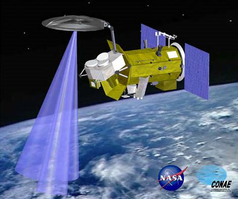
The $400 million Aquarius/SAC-D rocketed into space at 7:20:13 AM PDT. Less than 57 minutes later it separated from the rocket's second stage and began communicating with ground controllers and unfurling its solar arrays. The observatory was successfully launched from Vandenberg Air Force Base in California on June 10, 2011. Aquarius is a focused effort to measure Sea Surface Salinity and will provide the global view of salinity variability needed for climate studies. The mission is a collaboration between NASA and the Space Agency of Argentina.
* Click here to see NASA's Aquarius web site.

Getting By Without The Middle Class. The New York Times has the story: "NEW YORK — The big mystery in the United States today is why the job crisis is not at the center of the political and economic debate. After all, the numbers — and the human tragedies they reflect — could not be bleaker. Nearly 14 million Americans — 9.1 percent of the working population — are unemployed. That’s just a couple of a million shy of the populations of Greece and Ireland, Europe’s two problem children, combined. Another 8.5 million would like to work full time, but can only find part-time jobs. A further 2.2 million have been so discouraged by the grim labor market that they have given up looking for jobs altogether. It is hard to blame them — those still actively looking for work have been unemployed for an average of 39.7 weeks. These are cruel numbers, and they depict an unemployment crisis that is deeper and more sustained than at any time since 1948, when records first started to be kept. Yet the debate in Washington is focused on deficit reduction, rather than job creation. The news media are following the same playbook. A recent database analysis by The National Journal found that over the past two years, the leading newspapers in the United States had dramatically shifted their attention from unemployment to the deficit and were now publishing more than three times as many stories about the budget as they were about jobs.
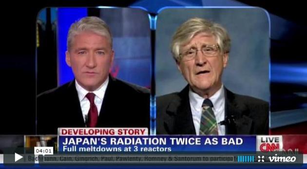
"Hot Particles" Discovered In Japan And The U.S. John King at CNN conducted a recent interview - shocking that we're not getting the full story out of TEPCO, the company that runs the crippled Fukushima nuclear plant: "CNN's John King and Arnie Gundersen discuss "hot particles" detected in Seattle and Japan, the cozy relationship between Japanese regulator NISA (Nuclear and Industrial Safety Agency) and plant owner TEPCO, and changes at the Fukushima accident site since March. John King and Arnie Gundersen also discuss how TEPCO's acknowledgement today of another error in calculating radiation dose more than doubles the amount of radioactivity to which people in the Northern Hemisphere have been exposed."

Extraordinary Hubble Photo Shows A Gigantic Exploding Death Star In Space - Or Homer Simpson. Now I've truly seen everything. Personally I think it's Homer. Gizmodo has more details: "Astronomers are in awe as they witness the evolution of Supernova 1987A using the Hubble Space Telescope. I don't blame them. It's awesome indeed. The actual explosion was first detected in February 1987, in the Large Magellanic Cloud. Yes. Flabbergasting Giganormous Pink Glitter Ring of Glowing Awesomeness it is. Or like Homer Simpson—right there in the middle—would call it: Mmmmmdoughnut. [NASA Goddard]"

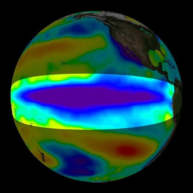
(One of the strongest La Nina cooling cycles of Pacific Ocean water in the last 20 years is finally over, according to NOAA).
An Early Autumn?
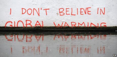
I know - NOT funny. Minnesotans earn their summers. We plot, scheme, daydream to make the most of these 12 magical weekends. When the weather doesn't cooperate we quickly lose our "Minnesota Nice". Weather is always changeable, variable, often severe, but the extremes I've witnessed so far in 2011 are meteorologically mind-blowing. Why? La Nina is weakening rapidly; the cool stain of water in the Pacific close to an "ENSO-neutral" state, in fact a mild El Nino may kick in later this year (a warmer winter?) Place your bets. So we can't pin all these wild swings in moisture & temperature on anomalies in the Pacific. What's left? Climate change may be prolonging droughts (and floods), possibly making heatwaves deadlier. Climatologists believe a warmer atmosphere could be a heat wave "enhancer". Strange times.
A swirl of cold air aloft will keep patchy clouds in the area today, highs stuck in the 60s - typical for mid September. The sun should break through, but with a cool north breeze it will probably feel more like mid September than mid June. A bubble of high pressure finally sweeps residual moisture to our east Sunday, with enough sun for mid 70s. Given a choice, schedule your romp in the lake or bike ride for Sunday.
80s return next week; just enough warmth to work up a (minor) sweat.
Climate Stories...
Monster Wildfire In Arizona: A Glimpse Of What Climate Change Could Bring. An article from the Christian Science Monitor: "A wildfire in Arizona that has blackened an area half the size of Rhode Island, prompted the evacuation of some 2,000 people in its path, and is threatening long-distance power lines that serve New Mexico and Texas, is the latest poster child for what some scientists see as a long-term trend toward larger, longer-lived wildfires in the American West. And as researchers explore the causes, climate change appears to be an important contributor. Nor is Arizona, which is battling three major blazes, alone in watching significant acreage go up in smoke this year. In Texas, whose fire season officially starts each Nov. 15, wildfires have already consumed a record 2.8 million acres this season, according to the state's Forest Service. That eclipses by far the record set during the 2006 fire season, when wildfires burned nearly 2 million acre. In Florida, firefighters are working to douse 35 wildfires larger than 100 acres, the largest of which has burned just over 160,000 acres near the Florida-Georgia border. Fire statistics gathered at the National Interagency Fire Center (NIFC) in Boise, Idaho, give a rough glimpse of the trend toward more scorched earth in the US. From 1960, when the center's tally begins, through 2010, wildfires throughout the US burned an average of 4.2 million acres a year. Between 2000 and 2010, however, the average rose to 6.6 million acres a year. Six of the last 11 years saw from 7 million to nearly 10 million acres burned. Between 1960 and 2000, only two years reached the 6-million-acre mark."
Study Of 800-Year-Old Tree Rings Backs Global Warming. The Seattle Times has the story: "The decline in recent decades of the mountain snows that feed the West's major rivers is virtually unprecedented for most of the past millennium, according to new research published today. By measuring tree-ring growth from forests with trees more than 800 years old, scientists from the U.S. Geological Survey and the University of Washington are showing that snowpack reductions in the late 20th and early 21st centuries have been unlike any other period dating back to at least the year 1200. Their work also shows that half or less of the recent declines can be explained by natural climatic shifts. The study was published online this morning in the journal Science. "I think the findings are pretty significant," said author Greg Pederson, with the U.S. Geological Survey. "It means trees are telling the same stories as computer models and instrument records — that human greenhouse gas emissions are contributing to the loss of snowpack. It's kind of hard to argue that warmer temperatures don't melt snow and ice."
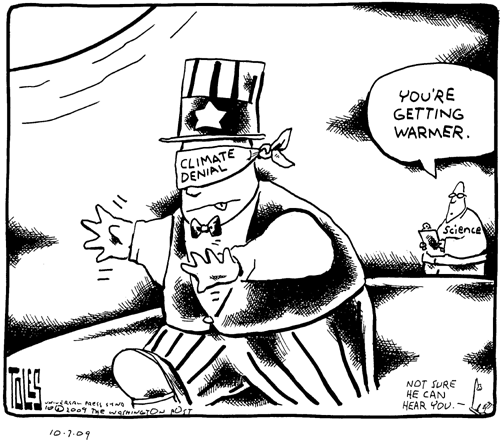
Academics Fear Climate Change Hate Mail Might Deter Future Researchers. The Sydney Morning Herald has the troubling story: "AUSTRALIAN climate scientists have revealed details of the offensive emails they are routinely subjected to, amid concerns that the vitriolic campaign could deter the next generation of researchers. The emails typically contain obscenities, insults and sexual slurs, with some including threats such as ''the quicker that c---s like you and your kind die, the better''. The Australian Academy of Science condemned the attacks yesterday, saying researchers had a right to do their work free from abuse, acts of intimidation and threats of violence. ''We call on leaders across the community to make the same defence of intellectual freedom,'' the academy's president, Professor Suzanne Cory, said. A climate scientist at the University of Melbourne, David Karoly, said he had been receiving abusive emails for more than two years, but the barrage intensified earlier this year. He referred a threatening one which said ''Die you lying bastard'' to police in January and they identified the person who sent it. No action was taken, however, because the police judged he was not at risk of immediate physical violence, Professor Karoly said."
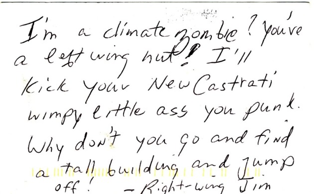
A Climate Change Wave Of Hate. It's come to this? Another article from the Sydney Morning Herald: "After 25 years writing this column, I've had my first experience of an internet hate campaign. So far, more than 2400 people, nearly all American, have emailed me. More emails come every time I hit the send/receive button. About 5 per cent contain threats of violence. Even stranger, quite a few threaten me with sexual violence. They say, in various forms, that they want to rape me. The only good news: quite a few don't seem to know the precise location of Sydney. Or Sidney, as some call it. ''You are so out of touch with America, I cannot believe you are published by an American paper,'' writes one emailer, having read the story on The Sydney Morning Herald website. Quite a few tell me I should be nervous if I ever try to leave Britain. Here's how it started. Last week, in this spot, I wrote a piece about climate change. It was critical of both the left and the right and contained some comic hyperbole about both: that environmental zealots wanted us all to live in caves and that climate-change deniers should tattoo their beliefs on their bodies so they couldn't later deny their role in preventing action on climate change."
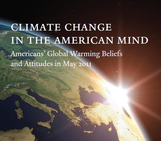
Anthony Leiserowtiz of the Yale Project on Climate Change Communication, one of the principal researchers, said that might reflect diminished news media coverage of the issue."
* "Climate Change In The American Mind", the pdf study, is here.

Is Romney Getting A Bum Rap For Global Warming? The Washington Post poses the question: "[In a town hall meeting] the former Massachusetts governor stuck to the position he has held for many years — that he believes the world is getting warmer and that humans are contributing to that pattern. Romney’s answer to the question about climate change last Friday during his first town hall meeting since announcing his second presidential campaign allowed him to demonstrate what he hopes voters will see as a new and improved candidate — an authentic leader with core convictions. . . .So far, Romney’s reviews from the right are not positive. His views about climate change in particular put him at odds with many in his party’s base. “Bye-bye, nomination,” Rush Limbaugh said Tuesday on his radio talk show after playing a clip of Romney’s climate remark. “Another one down. We’re in the midst here of discovering that this is all a hoax. The last year has established that the whole premise of man-made global warming is a hoax, and we still have presidential candidates that want to buy into it.” There are two issues here. First, do his views translate into any policy position at odds with the base? And second, will this be a disqualifier?"
I wondered why you recently suggested in the Trib that the numerous recent extreme weather events in Minnesota and nationally were not likely related to global warming. Aren't extremes of wet and dry as well as intensifying storm activity thought to be likely side effects of a warmer atmosphere? Thanks for making these materials on global warming available here.
ReplyDelete