89 F. high in the Twin Cities Wednesday.
.44" rain fell during the early morning hours at MSP International.
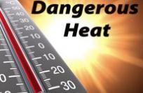
64 lives claimed by the intense heat & humidity, nationwide. Details below.
"Don" now a tropical storm, heading for Texas, now in the midst of the 3rd worst drought on record.
172 F. According to Wikipedia, the highest heat index ever recorded on the face of the Earth was 172 F, in Dhahran, Saudie Arabia, on July 8, 2003.
Tropical Updates. NOAA has a free service where you can get the latest tropical storm/hurricane updates via e-mail or SMS messages directly to your cell phone. Click
here, plug in your e-mail and preferences - you'll get updates automatically, as soon as they're issued by NHC.
Rising Sea Levels Threaten New Orleans. The story below from
nola.com.
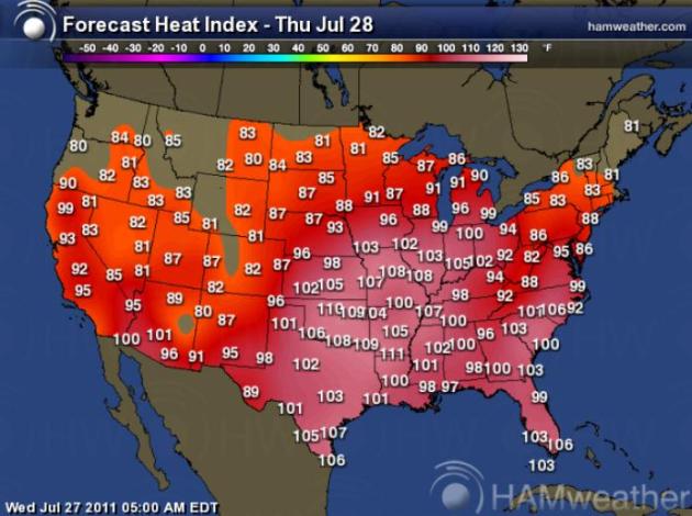
What Else? Hot & Steamy. The Jumbo Bake-a-thon that is the USA will continue to simmer today, the worst of the heat from Texas across the central USA into the Ohio River Valley and the Carolinas, where the combination of heat and dew points above 70 will make it feel like 105 to 110+. Map courtesy of Ham Weather.
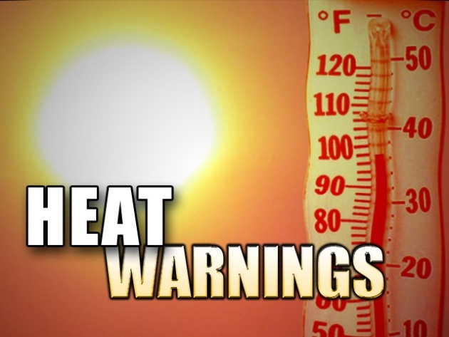
Grueling Heat. More heat-related facts & figures:
- In San Angelo, TX, the number of days the high temperature has reached 100°+ is 61 as of Tuesday, which has broken the old record of 60 set in 1969.
- In Abilene, TX, the number of days the high temperature has reached 100°+ is 47 as of Tuesday, which has broken the old record of 46 set in 1934.
- Tuesday: 56 days in a row of 90F+ temps in OKC. 2nd longest streak on the record books.
- Dallas forecast hit 102 Tuesday - Wednesday was the 26th straight day of 100-degree heat; will tie for 3rd longest stretch with August 1952.
- Tuesday: Fort Smith, AR forecast hit 103 today; will be the 22nd day in a row 100 degrees or higher. Longest streak in history, and still ongoing.
Heat Wave of 2011 Claims At Least 64 Lives. Details at the
Chicago Examiner.
- The massive heat wave that baked half the country in triple digit heat indexes last week have caused as many as 64 deaths in 15 states.
- This includes Chicago where the death toll recently jumped from 11 to 15. Other cities with heat related deaths include Philadelphia where at least 21 have past and Kansas City where at least 17 have died.
- The recent heat wave has retreated back into the southern Plains earlier this week, but is now starting to build across the Plains and Midwest regions. The heat will eventually build back across the Mid-Atlantic region later this week.
Tuesday Records:
- Wichita Falls, TX: 109 (tie) Old record: 109 in 1964
- Childress, TX: 108 (tie) Old record: 108 in 1940, 1944
- Fayetteville, AR: 100 Old record: 99 in 1998
- Alamosa, CO: 88 (tie) Old record: 88 in 2003
- Austin, TX: 103 (tie) Old record: 103 in 1964
- In San Angelo, TX, the number of days the high temperature has reached 100°+ is 61 as of Tuesday, which has broken the old record of 60 set in 1969.
- In Abilene, TX, the number of days the high temperature has reached 100°+ is 47 as of Tuesday, which has broken the old record of 46 set in 1934.
Wednesday Records:
- Salina, KS: 113 Old record: 111 in 1936
- Medicine Lodge, KS: 112 Old record: 110 in 1946
- Wichita, KS: 111 Old record: 106 in 1986
- Dodge City, KS: 109 Old record: 106 in 1946, 1960, 1983
- Russell, KS: 108 (tie) Old record: 108 in 1983
- Tulsa, OK: 107 Old record: 106 in 1936
- Oklahoma City, OK: 107 Old record: 105 in 1986
- Fort Smith, AR: 106 Old record: 105 in 1998
- Joplin, MO: 105 Old record: 103 in 1952
- Tyler, TX: 105 Old record: 104 in 1930
- Waco, TX: 105 (tie) Old record: 105 in 1977
- Fayetteville, AR: 100 (tie) Old record: 100 in 1998
Heat Claims 18 Lives In The Philadelphia Area. Photo courtesy of worldcitypics.com. Details on the heat:
- The death toll from one of the region's most-intense hot spells in the 138-year period of record has reached at least 18.
- The Health Department added eight additional heat-related deaths to the list Tuesday, bringing the Philadelphia total to 15.
- Three others were reported in neighboring counties as a result of the fifth, longest and most-oppressive heat wave of the season.
- Laurence Kalkstein, a research professor at the University of Miami who helped Philadelphia develop its acclaimed hot-weather warning system said, "Those numbers of deaths are really grossly underestimated." The real numbers, he added, may not be available until the mortality data becomes available in a year or two.
- Already, this has become the deadliest hot-weather season in Philadelphia since 2008, when heat was blamed for 26 deaths.
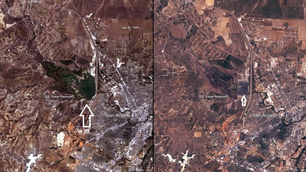
Texas Drought Continues To Worsen. The photo above (courtesy of
NOAA) shows the O.C. Fisher Reservoir just west of San Angelo, Texas. The image on the left was taken on July 31, 1985. The image on the right shows the same area, on July 11, 2011. The reservoir has virtually disappeared. Here are a few more (amazing) facts about the "exceptional" drought gripping Texas:
- 92% of Texas is under extreme drought.
- 75% of the state qualifies as experiencing exceptional drought - roughly 3.5 times the size of Georgia.
- Texas has officially experienced the driest nine-month period in the states history between October of 2010 and June 2011. This beat the previous record of June 1917 to February 1918.
- This is leading to widespread exceptional drought conditions -- which is nearing record levels (currently ranked as the 3rd worse in TX history).
- The worst of the drought is found in central and western Texas where precipitation deficits over the last 10 months exceed 20 inches in some areas. Midland and Lubbock have received less than 11 percent of their normal rainfall for the year so far.
- Drought is expected to worsen into August
- Of course, the dry conditions are also leading to a record wildfire season. According to the Texas Forest Service, a record 3.3 million acres of land have been burned since mid-November by more than 15,000 wildfires.
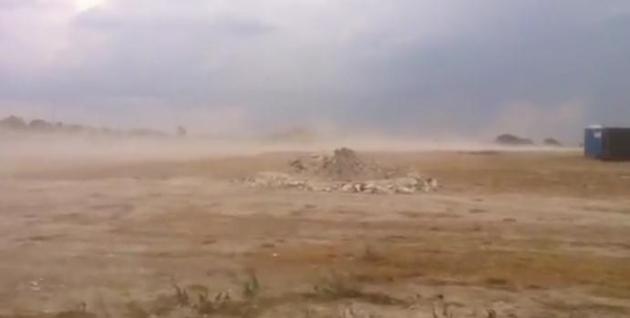
Texas Dust Storms. Check out this
YouTube clip from central Texas - there's precious little topsoil left. What Texas needs is a tropical storm or hurricane to put a real dent in the 3rd worst drought in the Lonestar State's history.
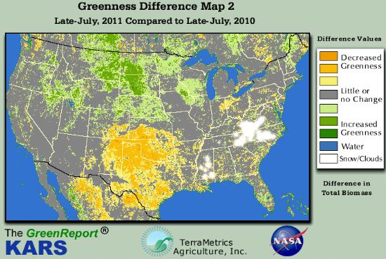
Drying Out. The Kansas Applied Remoting Sensing division of the U. of Kansas has a
series of graphics that show the rapid drying over the southern Plains states: Kansas, Colorado, Oklahoma, New Meixco and Texas are considerably drier than last year, while the Dakota and northern Minnesota are greener/wetter than July of 2010.
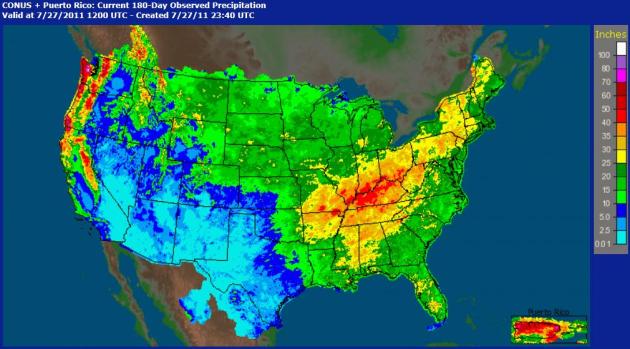
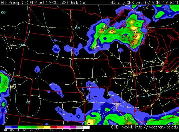
6 Month Precipitation. NOAA has an excellent
site where you can display rainfall amounts, for the last 24 hours, the last week, going back as much as 180 days. The dark red area shows over 40" of rain (and melted snow/ice) for the Ohio River Valley and parts of the Pacific Northwest since January 27. Note the lack of rain, less than 2" from Texas into southern California - some portions of Texas have seen less than two tenths of an inch of precipitation since January 1.
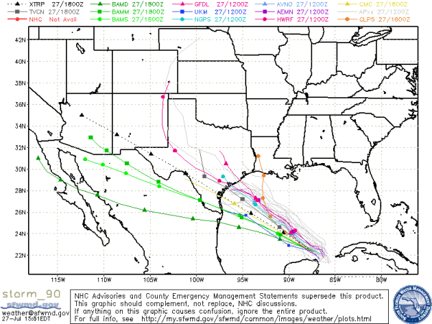
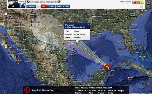
Tropical Storm Don This enhanced animation (courtesy of WSI) shows the coldest, thickest, heaviest rain-producing clouds as red/purple. This strengthening tropical storm is centered north of Cancun, Mexico, getting better organized by the hour. NHC is flying "Hurricane Hunter" aircraft into the storm, and further strengthening is anticipated, although odds are Don won't have enough "runway" (enough of a fetch of warm water) to become a major hurricane. That said, water temperatures in the Gulf of Mexico are in the mid 80s, ample fuel for further strengthening.
- Located about 120 miles N of Cozumel, Mexico or about 755 miles ESE of Corpus Christi, TX
- Maximum winds of 40 mph gusting to 52 mph
- Moving WNW at 12 mph.
- Minimum pressure at 1001 mb.
- There are no warnings currently in effect.
- A general northwestward motion is expected during the next 48 hours.
- The center of Don should move through the southern and central Gulf of Mexico Wednesday night and Thursday, and approach the coast of the northwestern Gulf of Mexico Friday.
- Gradual strengthening is forecast during the next 48 hours.
- Currently forecast to make landfall as a tropical storm between Corpus Christi and Galveston Friday evening or late Friday night.
- With a tropical storm approaching, Royal Dutch Shell says it has evacuated about 70 non-essential personnel from production and drilling operations in the extreme southwest Gulf of Mexico.
- The company says there has been no interruption of production - and none is currently expected.
- Another Gulf of Mexico petroleum operator - ExxonMobil Corp. - said it is monitoring the storm.
It's probably going to take more than one tropical cyclone to pull Texas out of an "exceptional" drought, but any rain would help at this point. Here is the official
NHC forecast track for "Don". Other models bring the storm closer to New Orleans by Friday afternoon, possibly as a minimal category 1 hurricane.
Latest Track Prediction. One model brings sustained winds close to 63 mph before Don comes ashore sometime Friday afternoon or evening. Map courtesy of NHC and Ham Weather.
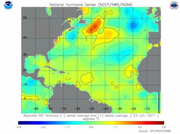
"High-Octane" Water. According to
NHC, water temperatures in the Gulf of Mexico are in the mid 80s, about 2-3 degrees F. warmer than average as of late July. The warmer the water, the greater the potential for intensification. The only caveat: any wind shear above the storm will shred the circulation and prevent the storm from winding up into a monster. Right now I suspect Don will strike the Gulf coast (probably Texas, but coastal Louisiana can't be ruled out) as a strong tropical storm or minimal, category 1 hurricane late Friday.
Web Site Of The Day. O.K. I'm giving away too many of my (geeky) secrets. But here is a favorite site, so you can check on Tropical Storm Don (Shelby) on your own. It's a mash-up of multiple sites, animations and maps - Mike's Weather Page (
spaghettimodels.com) has done a great job assimilating all this data and making it easy to navigate. 5 Stars.
Brewing Storm. Check out this spectacular
time-lapse, courtesy of webcams de Mexico, showing some of the other, spiral bands of Tropical Storm Don forming north of Cancun, Mexico.
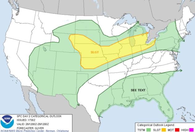
Flashing & Splashing. According to
SPC the greatest risk of severe storms on Thursday will come from Detroit and Cleveland into the Chicagoland area, Des MOines, Omaha, Kansas City, westward to the Black Hills of South Dakota.
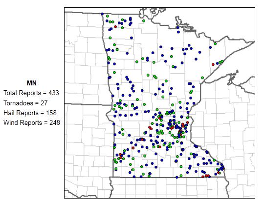
2011 Severe Storm Count In Minnesota. No, it hasn't been nearly as violent or severe as last summer across the Gopher State: 27 tornadoes, 158 reports of 1"+ hail, and 248 straight-line wind reports, according to SPC.
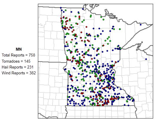
2010 Summary. Here is the final count from last year: an astounding, record-smashing 145 tornadoes in Minnesota (most in the nation!), 231 damaging hail reports and 382 separate reports of severe straight-line winds. Truly a summer season to forget.
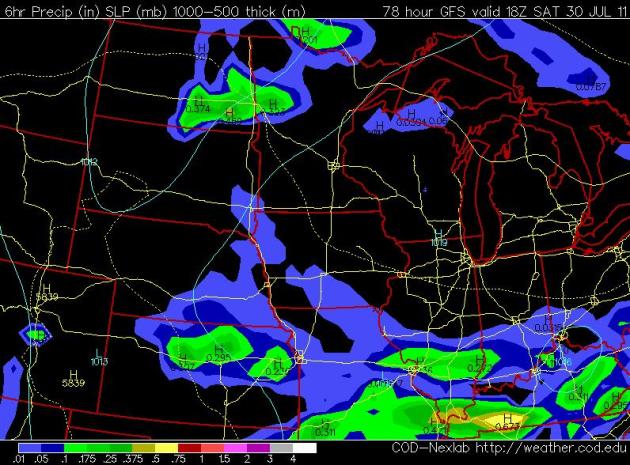
Weekend Daydreaming: Saturday Evening. The latest GFS extended model shows the best chance of PM T-storms over west central and far northern Minnesota. Most of the day should be hazy, dry and sunny, with dew points near 70 and mid afternoon temperatures within a degree or two of 90.
Sunday Evening. The same model shows an elevated risk of late afternoon/evening T-storms late Sunday, but much of the day should still be sunny and sticky (dew points still lurking in the upper 60s and low 70s). A classic mid/late summer pattern for Minnesota - finally.
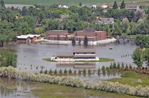
Bismarck, Minot Schools Rebuild, Rearrange, After Flood. The
Bismarck Tribune has the story of the massive clean-up effort now underway across North Dakota: "
Flooding in the western half of the state will cause schools in Minot to start eight days late, while Bismarck Public Schools is working to get affected students and needed supplies into different schools. Superintendents from both school districts met before the interim Education Funding and Taxation Committee on Tuesday to talk about some of the challenges presented by flooding along the Missouri and Souris rivers. Minot faces severe damage to many of its buildings as well as the task of setting up a number of portable classrooms. In the long term, the city will likely have to rebuild several schools. The tasks ahead of Bismarck are less daunting but still serious. Prairie Rose Elementary remains the most threatened by floodwaters, said Superintendent Tamara Uselman. The roughly 200 students and school staff will likely be integrated into Rita Murphy Elementary. The plan is to double up - putting about 45 students in each classroom at Rita Murphy along with two teachers. "It's going to be a tight squeeze, to be honest," Uselman said. "We're going to have to rethink and refigure space all over that building."
A Safe Place To Play After Tornado. Hundreds of kids (and their parents) were traumatized by the tornado that ripped across North Minneapolis on May 22. The
Star Tribune has a good story about play-therapy as a way to heal kids still suffering from a meteorological equivalent of PTSD, post traumatic stress disorder: "
Five-year-old Tiana Loyd put her hands over her ears last week when severe thunderstorms rumbled outside her Head Start classroom in north Minneapolis. The sounds mirrored the tornado that ripped through the community barely two months earlier. Loyd, whose home was damaged by the tornado, was comforted by her teachers and reassured that this time, it was not a tornado. She is among 130 children targeted by a special summer program that offers a safe place to play for children of families that were made homeless, were displaced or are waiting for repairs after the tornado. "They say the No. 1 tragedy is accidents that occur after a tornado," said Rico Alexander, director of Head Start and Early Head Start with Parents in Community Action (PICA). "With all of the debris, we wanted to get children off the streets while repairs are being done." The free program, run by PICA, received more than $276,000 from the Minnesota Department of Education, the Minnesota Department of Health and Human Services, the Office of Head Start in Washington, D.C., and Resources for Child Caring, a local child care education agency."
Astronomers Detect Largest, Most Distant Reservoir Of Water Ever Found In The Universe. Here's an excerpt of a fascinating article at
gizmag.com: "
Two international teams of astronomers have discovered the largest and farthest reservoir of water ever detected in the universe. The researchers found the huge mass of water feeding a black hole, called a quasar, more than 12 billion light-years away. The mass of water vapor is at least 140 trillion times that of all the water in the world's oceans combined and 100,000 times more massive than the sun. Quasars are among the most luminous, powerful, and energetic objects known in the universe. They are powered by an enormous black hole that steadily consumes a surrounding disk of gas and dust, spewing out huge amounts of energy as it eats. The particular quasar under investigation, which bears the catchy name of APM 08279+5255, harbors a black hole 20 billion times more massive than the sun and produces as much energy as a thousand trillion suns. Although astronomers had expected water vapor to be present even in the early, distant universe, they had not detected it this far away before. They point out that there is water vapor in the Milky Way, but because most of the Milky Way's water is frozen in ice, the total amount of water vapor is 4,000 times less than in the quasar."
Big Sunspots. Spaceweather.com has the story: "
After more than a week of quiet, solar activity is picking up. NASA's Solar Dynamics Observatory is monitoring two big sunspot groups now emerging over the sun's eastern limb. The leading sunspot group, AR1260, is crackling with M- and C-class solar flares among a quartet of Earth-sized cores. Not far behind, sunspot AR1261 is larger and may harbor energy for flares of its own. At the moment, these two sunspot groups are too far off disk-center to affect Earth, but this will change in the days ahead. Readers with solar telescopes are encouraged to monitor developments."
The Biggest Lie The Internet Ever Told: Free Everything, All The Time. Amen to that - here's an excerpt of a post at
gizmodo.com: "
Since you clicked your first link, you were promised one thing about the internet: you may have to pay a cover charge, but once you're in, everything's free. Except that suddenly doesn't seem as true anymore. You know what? Good. Hulu Plus. The NY Times paywall. Ditto Time magazine. Fox's decision to delay new episodes from streaming. Each one a flaming arrow launched straight at the heart of free. Outrage! Except for one thing: content on the internet was never going to be free forever. In fact, it's never actually been free at all. It's easy to forget—especially since I'd imagine, at this point, the internet has been around as long as most of you can remember—that web-based content is only just now coming out of its infancy. Newspapers and magazines wasted a decade dithering over exactly how much dead tree content to share online, and where, and how. Streaming TV shows and movies? We've only had the bandwidth to do that for a handful of years, and the implementation's been shoddy for most of them."
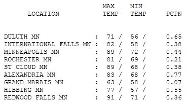
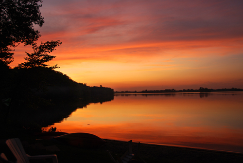
Prime Time Summertime. In spite of nearly half an inch of rain early Wednesday, there was enough afternoon sunshine for a high of 89 at St. Cloud and the Twin Cities, 91 at Redwood Falls. With clouds much of the day highs only reached 71 at Duluth and a downright brisk 63 at Grand Marais.
Paul's Conservation Minnesota Outlook for the Twin Cities and all of Minnesota:
TODAY: Lot's of sun, quiet. A dry sky statewide. Dew point: 67 Winds: South 5-10. High: 88
THURSDAY NIGHT: Mostly clear and mild. Low: 70
FRIDAY: Plenty of sun, still dry. Dew point: 64. High: 89
SATURDAY: Hazy sun, storms north. Dew point: 70 Winds: S 10-15. Low: 72. High: 92
SUNDAY: Sticky sun late storm? Dew point: 72 Winds: SW 10-15. Low: 74. High: 91
MONDAY : Bright sunshine, probably dry. Low: 70. High: 89
TUESDAY: Strong/severe T-storms possible. Low: 72. High: 88
WEDNESDAY: Sunnier, cooler, less humid statewide. Low: 70. High: 83
Mellowing Out
The Summer of '11 is going by way too fast. It's been a wild ride: sweatshirts to 103 F. heat in less than week back in early June, 158 reports of large hail, & a bout of record-shattering heat an humidity last week. Last Tuesday the dew point rose to a record 82 at MSP (84 in-between hours), creating an historic heat index in the cities: 124 F. Remarkable. I may regret saying this (in print) but I suspect the worst of the heat/humidity is in our rear-view mirror.
As we sail into August (how did THAT happen?) we should see fewer severe storms, less flash flooding and more subdued heat. Then again, we've all discovered there is no such thing as "average weather" in Minnesota.
One bright note: after enduring 145 tornadoes in 2010 Minnesota's tornado count has been lower this summer: 27 tornadoes so far.
Yesterday's thundery frontal boundary gets a southward nudge today; the sun should be out most of today & Friday, highs in the upper 80s. Lake-loitering is encouraged over the weekend with daytime highs near 90; the best chance of late-day storms on Sunday. My next invention: a way to freeze time. Memorize the sky the next few days; as good as it gets in (late) summer. Ugh.
Climate Stories....
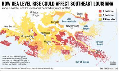
New Orleans Is One Of A Dozen Cities At Risk From Global Warming, Environmental Group Says. More details from
nola.com: "
New Orleans is one of a dozen U.S. cities most at risk from the effects of global warming, a threat that city officials here have recognized and are responding to in the aftermath of Hurricane Katrina, concludes a new report released today by the Natural Resources Defense Council. Other cities on the list include New York; Miami; Norfolk, Va.; St. Louis, Mo.; Los Angeles and Seattle, according go the environmental group’s report, “Thirsty for Answers: Preparing for the Water-related Impacts of Climate Change in American Cities.” The report “is a national call to action, but not a call to alarm,” Steve Fleischli, senior attorney with the group’s water program, said today. “Yes, our communities can be resilient in the face of water-related vulnerabilities to climate change, but they must plan, prepare and act, and the sooner the better.” The report relies on a wealth of peer-reviewed or government-sponsored scientific reports to describe the effects of global warming on individual cities and on similar reports, combined with official plans of state and local governments, to describe cites’ responses to climate change."
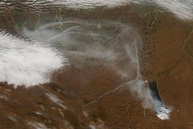 Arctic Fires May Accelerate Global Warming
. The story from Australia's
ABC News: "
A study has found fires in the Arctic are on the rise, which could accelerate global warming. Research published in the journal Nature shows that as global temperatures rise, the Arctic will not be spared, and fires like these may become more common and more severe. The organic-rich soil of the Arctic - the fastest warming region on the planet - is highly flammable but also has the capacity to store large amounts of carbon. The study reveals how a single fire can rapidly change the carbon balance of the region and instead of storing emissions, it can emit large amounts into the atmosphere. "If the Arctic continues to warm, you know the landscape around me is covered with organic soil that... historically in places like Britain people burn that as a fuel source. It's highly flammable," said Michelle Mack, one of the scientists behind the study. "So if the climate continues to warm and there are periods when the Arctic is dry then I think we're going to see more fires and there's plenty of fuel to fuel fires." It is hard to imagine a region normally blasted by freezing temperatures can also be home to fires."
U.S. Congress Looking After The World (Or Not?) Stephan Lewandowsky at
shapingtomorrowsworld.org has the post, a reaction to the U.S. House of Representatives barring funds for international climate adaption efforts. "
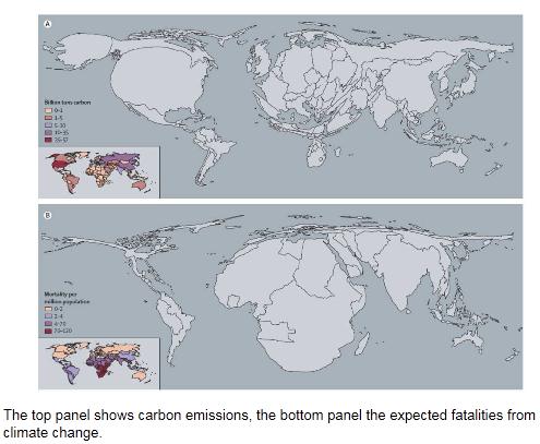
The House Committee on Foreign Affairs voted to prohibit the use of funds to assist developing countries adapt to climate change or transition to sources of clean energy. The Committee passed H.R. 2583, the Foreign Relations Authorization Act for Fiscal Year 2012, with an amendment from Rep. Connie Mack (R-FL) to prohibit the use of funds for the Global Climate Change Initiative, which is part of the United Nations' effort to help provide assistance to developing countries. The House Agriculture and Homeland Security spending bills also contain similar provisions. Right. So, the country that bears greater historical responsibliity for carbon emissions than any other is barring funding for adaptation by countries who now do the suffering. The medical journal Lancet (Costello et al., 2009) had an informative graph on this issue recently (above).
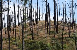
Yellowstone Fire Cycle Undergoing Dramatic Change.
Technorati Technology has the story: "
A recent study in the journal Proceedings of the Natural Academy of Sciences presents significant evidence that the ongoing climate change is increasing the likelihood of large forest fires in the Greater Yellowstone Ecosystem. A shift of this magnitude is likely to drive massive changes to both animal and plant life in the area. This forested ecosystem around the world's first national park has been affected by forest fires for thousands of years, but these fires have been relatively small in magnitude to the ones projected in the future. Historically, fires that burn more than 500 acres are very rare but current forecast models show these fires could occur annually by the year 2050. In the past, the entire 20 million acre ecosystem would be completely burnt every 100 to 300 years. This time span over which an entire landscape burns, called fire rotation, is forecasted to be shortened to less than 30 years."
Memo To Climate Change Pundits: Don't Mention The Weather. Chris Turner from
Mother Nature Network has an intriguing article about the psychology of climate change, and the perils of linking climate change with the record heat and drought gripping much of America. Not sure about this one, but in the spirit of full disclosure, here's a snippet: "
So let’s return to the weird weather frame for climate change. On the one hand, climate scientists have been saying for many years now that the first significant signs of climate change will be greater numbers of increasingly extreme weather events – hurricanes and tornadoes and blizzards, record flooding and drought, and, yes, heat waves. And because these events are acute, destructive and widely observed, they’d seem like ideal cases in point for the emerging climate crisis. But hold on a moment and consider the frame. Weather is by its nature unpredictable, and it is understood – scientifically as well as at gut level – as beyond our control. As Kate Sheppard of Mother Jones notes in her brief response to this summer’s heat wave, it was beyond asinine for Senator James Inhofe to use the snowy winter of 2010 as evidence that climate change wasn’t happening, because not only is the weather in Washington, D.C. dependent on numerous factors beyond greenhouse gas emissions, but weather is not climate and record snowfall is itself a likely sign of climate change."
Conservative, White Men More Likely To Be Climate Change Skeptics, Study Shows. The story from the U.K.'s
Guardian newspaper: "
The more you think you know, the more you think you're right," goes an old saying. Now comes a study of sex, skin color and political ideology that suggests it pretty much sums up how some white male conservatives in the United States respond to climate change. "Even casual observers" of those who argue that climate change isn't a serious problem "likely notice an obvious pattern," Aaron M. McCright of Michigan State University in East Lansing and Riley E. Dunlap of Oklahoma State University in Stillwater write in Global Environmental Change: "The most prominent denialists are conservative white males" – from media pundit Rush Limbaugh to politicians like Oklahoma Senator James Inhofe. But the pair wondered: "Does a similar pattern exist in the American public?" To find out, the researchers analyzed ten annual polls on environmental issues conducted by the Gallup Organization from 2001 to 2010. Together, they included responses from more than 10,000 adults. After slicing and dicing the numbers, the trends were clear: "Conservative white males are significantly more likely than are other Americans to endorse denialist views," they write. And "these differences are even greater for those conservative white males who self-report understanding global warming very well."
Limbaugh Theory: People Believe In Global Warming Because Air Conditioning Makes Their Homes Cool. The logic escapes me, but for the record, here are the details, courtesy of
mediamatters.com: "
From the July 26 edition of Premiere Radio Networks' The Rush Limbaugh Show."
Conservatives Avoid Global Warming Talk During Heat Wave. I've noticed this too - my ultra-conservative friends (who still believe climate change is a hoax or "liberal plot" and we all bow down to Al Gore) love to rant and rave when it snows - "where's your global warming NOW, Paul?" I don't hear so much from these people during historic heat waves or record droughts, like the one we're experiencing in 2011. David Pakman takes a look at the double-standard in this
YouTube clip: "
Have you noticed how Fox News and other conservative media aren't claiming that the recent heat wave is proof of global warming, even though cold winter days make them claim there is no global warming?"
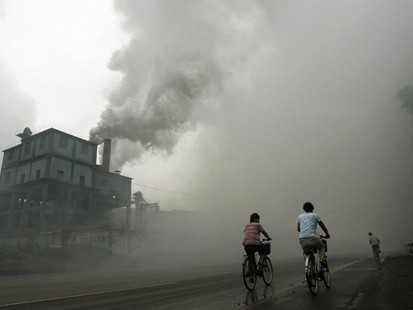
Are China's Factories Keeping A Lid On Global Temperatures? Here's a story from
carbonpositive.net: "
The results of a new climate study released this month may hold significant implications for the battle to constrain global warming; they may answer the climate sceptics’ argument that “global warming stopped in 1998”, raise a horrible dilemma over actions to tackle climate change and control acid-rain pollution, and add weight to calls for geo-engineering of the earth’s atmosphere to stop global warming. The study, by National Oceanic and Atmospheric Administration (NOAA), suggests that rapid industrial growth in Asia, particularly China, where air pollution controls are not as strict as North America or Europe, has seen large emissions of global-cooling sulphur pollution into the atmosphere since 2000. This may explain why it is that, when global warming emissions of carbon dioxide rose sharply along with this industrial expansion, global temperatures over the decade did not rise any higher than the record year of 1998. The 2000s were measurably warmer than the 1990s with more very warm years at the top at the top of the historical range. But only in 2010 did any single-year average global temperature reach that of 1998, and this has seen climate change sceptics argue that global warming has stopped." (photo courtesy of
absolute-truths.com).


No comments:
Post a Comment