1.15" rain predicted for MSP by Friday evening (NAM model).
5-6 days/row above 90, from Friday into at least Tuesday of next week.
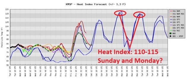
110-115 F : predicted heat index for MSP Sunday and Monday (I expect the NWS to issue an Excessive Heat Warning).
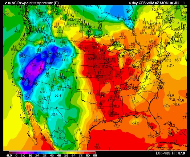
75-80: weekend dew points may approach 80 in the Twin Cities, oppressively humid weather likely.
Flash Flood Watch posted from Minneapolis westward to Willmar and Mankato, covering much of central/southern MN from Wednesday night into Thursday. T-storms may dump out some 1-3"+ rainfall amounts as hot air pushes north again.
45 days above 100 at Wichita Falls, Texas so far this year.
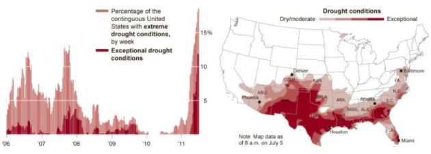
$265 billion: estimated insured losses from weather-related disasters so far in 2011, the most expensive year on record, according to Munich Re. The previous record: $220 billion in 2005.
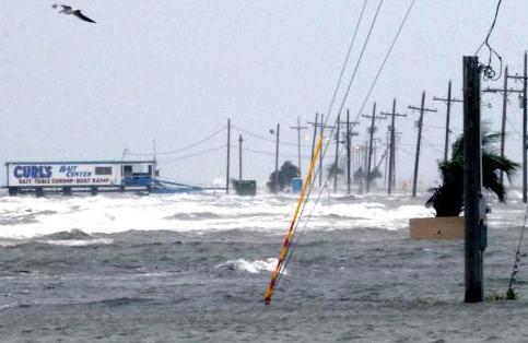
"...Most U.S. tropical cyclone deaths occur from drowning," says hurricane center deputy director Ed Rappaport. "Storm surge accounted for about half of the losses since 1970." - USA Today article below on the danger posed by hurricane storm surges.

"...The global warming debate has devolved into an emotional argument, not a logical one. Emotions are incredibly difficult to change because they don’t respond to facts or logic. Once an argument becomes emotional, a person will defend his or her position to the bitter end, no matter what the evidence may be." - from an article below on science vs. emotion & ideology at American Leader.

"...scientists have made a frightening forecast: one in 10 species will be extinct by 2100 if climate change continues affecting the world the way it is now. “Our study is a wake-up call for action,” lead author Ilya Maclean said in a statement. “The many species that are already declining could become extinct if things continue as they are. It is time to stop using the uncertainties as an excuse for not acting.” - Time Magazine article below on climate change and species extinction.
Record Highs On Tuesday:
- Fort Smith, AR: 108 Old record: 107 in 1954
- Raleigh-Durham Airport, NC: 100 Old record: 98 in 1986
- Vicksburg Tallulah Airport, LA: 99 Old record: 98 in 1960, 1966, 1980, 1998
- JFK Airport on Long Island, NY: 98 Old record: 94 in 1993
- Bridgeport, CT:: 95 Old record: 94 in 1966
- Islip, NY: 93 Old record: 91 in 1993
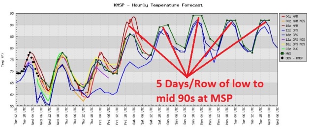
Outlook: Extended Heatwave. Models are all fairly consistent: 90+ heat from Friday into at least Tuesday of next week, possibly some mid 90s Sunday and Monday. Factor in a dew point in the mid 70s and the heat indices will be VERY noticeable - up in the danger zone.
Good Weekend For The Lake. Dew points are forecast to surge well into the 70s to near 80 (!) That will translate into a heat index as high as 110-115 by Sunday and Monday. I fully expect the NWS to issue Excessive Heat Watches and even Excessive Heat Warnings for much of central and southern Minnesota. It may be a few degrees cooler up north. Your best bet to escape the extreme heat: the North Shore of Lake Superior, where a cooling breeze off the lake may keep highs in the 80s to low 90s. Some cool front.
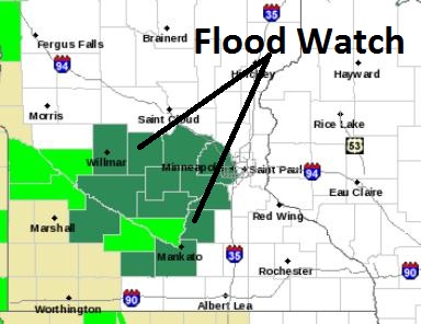
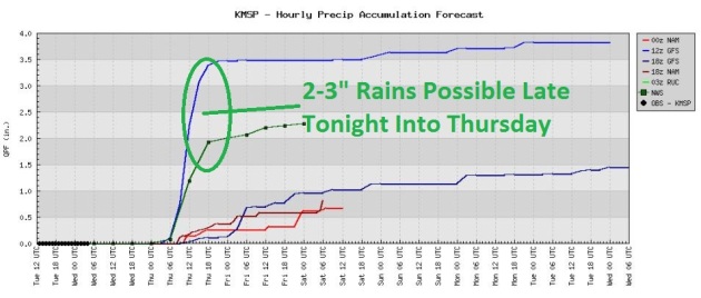
Potential For Urban/Stream Flooding Thursday. The arrival of super-heated air will leave the atmosphere extra-irritable late Wednesday night into Thursday, a potential for an MCS system, a meso-convective system capable of torrential rain, frequent lightning and strong/gusty winds sweeping out of Omaha into southern/central Minnesota late tonight into Thursday. Some minor flooding is possible - if you live in a flood-prone area you'll want to stay alert & stay tuned for more information. From the local NWS office:
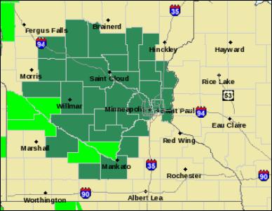
...FLOOD WATCH IN EFFECT FOR PORTIONS OF CENTRAL AND SOUTHERN
MINNESOTA WEDNESDAY NIGHT INTO THURSDAY...

.A FLOOD WATCH REMAINS IN EFFECT FOR LATE WEDNESDAY NIGHT THROUGH
THURSDAY AFTERNOON. THE WATCH IS ALONG A LINE FROM THE TWIN
CITIES ON WEST TO WILLMAR AND THEN SOUTH TO A LINE FROM ST. JAMES
TO MANKATO.

A WIDESPREAD AREA OF SHOWERS AND THUNDERSTORMS IS EXPECTED TO
MOVE INTO THE WATCH AREA WEDNESDAY NIGHT...AHEAD OF AN APPROACHING
WARM FRONT. AN UNSEASONABLY MOIST AIRMASS WILL BE FEEDING INTO
THESE SHOWERS...WHICH WILL HELP ENHANCE RAINFALL AMOUNTS. FOR THE
WEDNESDAY NIGHT THROUGH THURSDAY AFTERNOON PERIOD...ONE AND ONE
HALF TO TWO AND ONE HALF INCHES OF RAIN IS EXPECTED ACROSS THE
WATCH AREA...WITH LOCALLY HIGHER AMOUNTS POSSIBLE.

RECENT HEAVY RAINFALL ACROSS THE WATCH AREA WILL MAKE MANY LOCAL
STREAMS AND LOW LYING AREAS SUSCEPTIBLE TO FLOODING IF RAINFALL
AMOUNTS THIS HIGH CAN BE REALIZED.
Trending Wetter: Recent models are hinting at as much as 1-3" rain from late tonight into Thursday as strong/severe storms flare up along a vigorous warm frontal boundary surging north, the leading edge of intense heat that will grip much of Minnesota over the weekend.
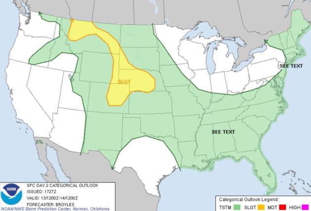
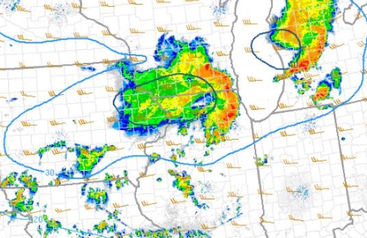
Wednesday Severe Threat. SPC shows the greatest risk of hail and damaging winds from Montana southward through the Front Range of Colorado, eastward across Nebraska. I have a hunch T-storms pushing across the Dakotas into Iowa and southern Minnesota may approach severe limits late tonight into Thursday along the leading edge of intense heat.
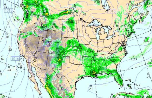
Thunder-Potential The WRF/NAM model (valid 7pm Wednesday evening) shows numerous showers and T-storms from Colorado's Front Range to the Dakotas, southward to Kansas City, New Orleans and Huntsville. More storms will sprout over Florida, a few instability PM showers/sprinkles for New England as a northwesterly flow cools off Boston and Portland. Meanwhile the west stays dry, more wind-whipped showers and unusually cool weather for Seattle.
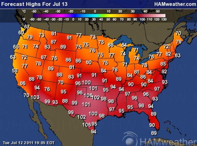
Expanding Heatwave. It's deja vu all over again: more 100s over the southern half of the nation, while comfortable 70s settle in over the northern USA, cool 50s and 60s over the western USA. Map courtesy of Ham Weather and NOAA.
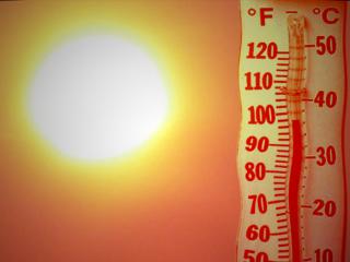
Hot Enough For 'Ya? The short, polite answer is...."yes". A few hot weather factoids:
- Blistering mid-summer heat seared much of the southern, central and eastern USA on Tuesday, as temperatures soared above 100 degrees in cities from Kansas to South Carolina.
- Nearly half of the USA's population — 150 million people — were affected by the heat Tuesday, according to the National Oceanic and Atmospheric Administration, as the National Weather Service posted heat advisories or heat warnings in parts of 23 states from Oklahoma to Connecticut.
- Oklahoma City suffered through 13 straight days of 100-degree or above heat before ending the streak on Tuesday. (Tuesday's high was "only" 97.) Dallas has had 100-degree temperatures for 11 days in a row, including Tuesday.
- Although a brief break in the heat is forecast for parts of the Great Lakes, Northeast and Mid-Atlantic over the next few days, there will be no relief across the scorched Plains or Deep South.
- Almost the entire country east of the Rockies is forecast to see above-average temperatures throughout next week.
- The heat and drought have led to record wildfire activity. The year-to-date acreage burned nationally so far is at 5.8 million acres — the most on record for the period — and almost twice the decadal average, says the National Interagency Fire Center.
- 67-year-old Ed Green of Philadelphia, PA died after being rushed to the hospital on Tuesday afternoon and medics believe he was a victim of the extreme heat.
- Officials are still trying to piece together what happened to a 4-year-old girl who was found dead in her family’s SUV Monday night in Cleburne, Texas.
- Lilly Parson’s parents said she had been playing outside and then disappeared. After a brief search, they called 911 for help.
- Deputies who responded to the call found the girl’s body lying on the back seat of her family’s vehicle, which was parked in the driveway.
- Investigators suspect the triple-digit heat played a role and they are treating the case as an accident.
- Officials are still questioning the girl’s parents. They reportedly have been cooperative but there inconsistencies in the accounts of how long she had been missing, the sheriff’s department said.
- A heat wave that has pushed temperatures well over 100 degrees has killed tens of thousands of turkeys.
- In North Carolina, about 50,000 chickens died at a farm after the power went off for 45 minutes. In Kansas, one couple lost 4,300 turkeys that took 26 hours to bury.
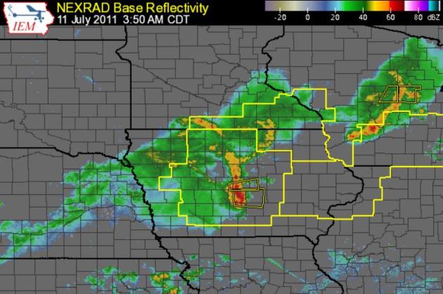
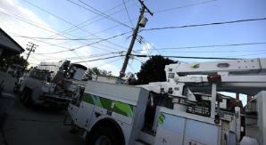
Iowa Derecho. The wind storm that swept across Iowa (into Chicago Monday morning) was Iowa's worst wind event since 1998, according to the Des Moines office of the National Weather Service. Here are the details:
PUBLIC INFORMATION STATEMENT
NATIONAL WEATHER SERVICE DES MOINES IA
458 PM CDT MON JUL 11 2011
...PRELIMINARY DAMAGE SURVEY RESULTS FOR STORY...MARSHALL AND TAMA
COUNTIES...
THIS STORM SURVEY INVESTIGATION IS STILL ONGOING AND SUBJECT TO
FURTHER COORDINATION WITH LOCAL EMERGENCY MANAGEMENT AGENCIES.
...WIDESPREAD AND EXTREME STRAIGHT LINE WIND EVENT...
THE FOLLOWING IS A PRELIMINARY ASSESSMENT FOR THE DAMAGE THAT
OCCURRED OVER STORY...MARSHALL AND TAMA COUNTIES...OR FROM CENTRAL
INTO EAST CENTRAL IOWA...EARLY IN THE MORNING ON MONDAY...JULY
11...2011.
* EVENT DATE: 07/11/2011.
* ESTIMATED START TIME: APPROXIMATELY 320 AM CDT.
* EVENT TYPE: DERECHO. NO TORNADOES WERE INDICATED DURING THIS
EVENT. THIS PARTICULAR DERECHO BEGAN IN CENTRAL IOWA AND
TRAVELED ACROSS CENTRAL AND EASTERN IOWA...AS WELL AS ACROSS
ILLINOIS...LAKE MICHIGAN...MICHIGAN...AND ENDED IN ONTARIO
CANADA. THIS DERECHO TRAVELED FROM CENTRAL IOWA TO DETROIT
MICHIGAN...OR A DISTANCE OF APPROXIMATELY 550 MILES...OVER THE
TIME SPAN OF NINE HOURS. A DERECHO IS A LONG LIVED...
WIDESPREAD...DAMAGING WIND STORM WHICH IS ASSOCIATED WITH
RAPIDLY MOVING SHOWERS AND THUNDERSTORMS. DERECHOES ARE OFTEN
CURVED OR BOWED IN THEIR SHAPE. WINDS IN DERECHOES CAN EXCEED
100 MPH. THE WINDS ASSOCIATED WITH DERECHOES ARE NOT CONSTANT
AND MAY VARY CONSIDERABLY ALONG THEIR PATHS.
* EVENT LOCATION: BEGAN JUST WEST OF INTERSTATE 35 IN SOUTHERN
STORY AND NORTHERN POLK COUNTIES. CONTINUED EASTWARD INTO
MARSHALL AND TAMA COUNTIES.
* PEAK WIND: THE HIGHEST WINDS WERE AT LEAST 80 TO 105 MPH.
* PATH WIDTH: THE PATH WIDTH OF THE STRONGEST...HIGH-END WINDS
WAS IN TAMA COUNTY AND WAS 5 MILES WIDE. IN ADDITION...THERE WAS
A 10 MILE WIDE PATH OF WIND SPEEDS OF 70 TO 80 MPH. THERE WAS
ALSO A 15 TO 20 MILE WIDE PATH OF WIND SPEEDS OF 60 MPH OR
GREATER. IT SHOULD BE NOTED THAT THE DAMAGE SWATHS FROM THESE
WINDS WERE NEARLY CONTINUOUS...AND EXTENDED FROM SOUTHERN STORY
AND NORTHERN POLK COUNTIES...ACROSS MARSHALL AND TAMA COUNTIES.
* PATH LENGTH: THE DAMAGE SWATHS FROM THESE WINDS WERE NEARLY
CONTINUOUS...AND EXTENDED FROM SOUTHERN STORY AND NORTHERN POLK
COUNTIES...ACROSS MARSHALL AND TAMA COUNTIES.
* INJURIES: NONE HAVE BEEN REPORTED TO THE NATIONAL WEATHER
SERVICE IN DES MOINES THUS FAR.
* FATALITIES: NONE HAVE BEEN REPORTED TO THE NATIONAL WEATHER
SERVICE IN DES MOINES THUS FAR.
* DISCUSSION/DAMAGE: THIS WIND EVENT HAS BEEN THE MOST WIDESPREAD
AND DAMAGING ONE TO AFFECT CENTRAL AND EAST CENTRAL IOWA SINCE
1998. AGAIN...NO TORNADOES WERE INDICATED. THE DAMAGE WAS DUE TO
STRAIGHT LINE WINDS FROM A DERECHO. HAVING SAID THAT...THE
STRONGEST WINDS DURING THIS EVENT WERE SIMILAR TO THOSE FOUND IN
AN EF1 TORNADO. THE WIND DAMAGE FROM THIS EVENT WAS MORE
WIDESPREAD THAN THE DAMAGE A TORNADO HOWEVER. EXAMPLES OF THE
NOTABLE WIND SPEEDS FOLLOW AND HAVE BEEN ESTIMATED FROM OBSERVED
DAMAGE. NEAR HUXLEY...96 MPH. MAXWELL...94 MPH. NEAR
MARSHALLTOWN...70 TO 90 MPH. JUST EAST OF GARWIN...105 MPH.
BETWEEN GARWIN AND UNION GROVE STATE PARK...85 TO 97 MPH. JUST
SOUTH OF TRAER...100 MPH. JUST SOUTH AND SOUTHWEST OF
DYSART...105 TO 110 MPH. SOUTH OF DYSART...80 TO 100 MPH.
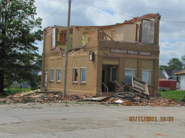
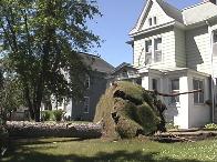
Iowa Damage. The Quad Cities area was hit especially hard by severe straight-line winds on Sunday, possibly reaching 130 mph. The photo above is from the public library in Garrison, Iowa. More details from the local NWS: "A strong thunderstorm complex moved through East Central Iowa and Northern Illinois early Monday morning, July 11th. Damaging winds in excess of 70 mph uprooted large trees, downed power lines, and ripped roofs off of buildings. Areas heavily impacted by storms were in Northeastern Benton County, Northern Linn County, and Southern Delaware County. ....At Garrison Iowa: straight line wind of 110 to 130 mph produced widespread damage to structures. Many roofs were partially or fully removed and the walls of some buildings collapsed. Nearly every tree was significantly damaged or snapped off . Power outages were widespread."

2011: Already A Record Year For Insured Losses In The USA:
- Halfway through, this year is already the costliest on record for natural catastrophes, insurer Munich Re said Tuesday in its first-half review. Losses hit $265 billion in the first six months of 2011 – which exceeds the $220 billion in losses in the biggest previous year for natural disasters, 2005.
- Most of the losses this year stem from the March earthquake and tsunami in Japan, which caused more than 15,000 deaths and accounted for $210 billion in economic losses. That is another record, beating out the $125 billion in losses caused by Hurricane Katrina in 2005.
- Losses tied to the quake have already taken a toll on insurance industry profits. First-half insured losses hit $60 billion, Munich Re said – five times the annual average over the past decade.
- The question now is how high this year's record toll might rise. Munich said first-half losses "are generally lower than second-half losses, which are often affected by hurricanes in the North Atlantic and typhoons in the Northwest Pacific."


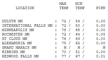
Tuesday: Calm Before The Hot Front. Enjoy the Canadian air while you can - 70 degree highs linger into Thursday (although humidity levels will rise dramatically tomorrow). Highs yesterday ranged from 70 at Hibbing to 76 at St. Cloud, 78 in the Twin Cities.

Paul's Conservation Minnesota Outlook for the Twin Cities and all of Minnesota:
TODAY: Partly sunny, breezy - probably dry during the day. Winds: SE 15+ High: 77
WEDNESDAY NIGHT: Flash Flood Watch. T-storms develop, potentially heavy rain late. Low: 60
THURSDAY: Flash Flood Watch. Strong T-storms, flash flood risk? High: 74
FRIDAY: "Hot front." Sunny and steamy. Dew point: 75-80! Low: 69. High: 93
SATURDAY: Tropical sunshine, isolated PM thunder? Winds: SE 10-15. Low: 76. High: 94
SUNDAY: Sizzling sunshine, potentially dangerous levels of heat/humidity (I expect a Heat Watch or Warning by Sunday). Heat index: 110? SW 10-15+ Low: 79. High: 96
MONDAY: Still hot. Partly sunny with an Isolated T-shower. Low: 77. High: 93
TUESDAY: 5th day/row above 90? Another free sauna. Low: 75. High: 92

Important Reminder
After the Winter-That-Would-Not-End and a fickle, soggy & cool spring, I'm not about to complain about the heat. At least not yet. Weekend highs will reach the mid 90s. Factor in a dew point close to 80 and Sunday's heat index may top 110. I expect heat watches & warnings to be issued for the metro area. We'll get a taste of the heatwave gripping much of the USA, maybe 5-6 days/row above 90.
Every year an average of 38 children perish in hot vehicles. Their parents are running errands - leave their kids in the car, and are shocked to discover that in the span of 10 minutes the temperature inside their vehicle has soared to 120-140 F. That's one (needless) tragedy every 10 days, somewhere in the USA. Cracking a window won't help, either. Take the heat seriously, and remember that PETS feel the heat just as much as we do.
The arrival of super-heated air may set off a round of heavy/severe storms late tonight into Thursday. By Friday highs surge into the 90s, beastly-hot weather spilling over into early next week. It could be worse: Dallas has topped 100 12 days/row.
Be glad you didn't buy that little getaway down in Wichita Falls, Texas. 45 days above 100 this summer. Ouch!

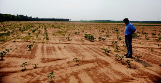
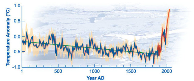
Can We Blame The Drought On Global Warming? For 30 years climate models have shown a distinct trend toward hotter, drier summers, especially west of the Mississippi. What we're witnessing now is consistent with anthropogenic climate change: more extreme storms, heavier rainfall amounts, especially over the northern and eastern USA, but a tendency for more prolonged (and severe) heat and drought over the southern and western USA. Salon.com has the story: "Fourteen states in the southern U.S. are suffering through the nation's worst drought in 60 years: a dry spell that, when all is said and done, might measure against the most severe in the country's history. The New York Times made that news one of its top stories in Tuesday morning's print edition, painting a vivid picture of parched and fallow farmlands from Florida to Arizona, and an agricultural industry buckling against drastically reduced output and a stagnant economy. But one element of the story notably absent from the Gray Lady's analysis is the specter of man-made climate change. The Times story warns that the current drought could rival those seen during the Dust Bowl days. It also mentions that the dry spell is the result of a familiar meteorological phenomenon called La Niña -- which, it notes, "is an abnormal cooling of Pacific waters [that] usually follows El Niño, which is an abnormal warming of those same waters." But to what extent are these multiplying abnormalities attributable to anthropogenic climate change? We don't know, because the Times skirts the issue. The Washington Post's weather blog notes that "La Niña wasn't the only force behind the drought," but cautions that "the co-conspirators remain unknown." That article then goes on to quote NOAA climate scientist Marty Hoerling, who said that the current dry spell does not appear to be a "climate change drought" (though he also warned that warming global temperatures have already exacerbated, and would continue to exacerbate, extreme weather in the future). "

Will Global Warming Make The Planet More Humid Too? The story from slate.com: "Hot, muggy weather created dangerous conditions for residents of the South and Midwest on Tuesday, and there were reports of heat-related deaths. We all know that it's impossible to link any particular heat wave to the phenomenon of global warming, but those of us suffering in humid areas have to be wondering—is the Earth getting wetter, too? Most climatologists think so. The planet's total humidity seems likely to rise in the coming years. But there's a difference between that figure—which represents the mass of all the water vapor in the air—and the planet's relative humidity, which describes how close the air is, on average, to its saturation point at a given temperature. Total humidity is the more important metric for the planet, because water vapor is itself a greenhouse gas. Relative humidity, on the other hand, is more closely associated with human comfort, because it affects your ability to cool off by sweating. Few scientists profess to know with certainty what's going to happen to either measure over the next few decades or centuries. There's very little global data (PDF) on the issue, and those that do exist are in dispute. The majority view appears to be that relative humidity will remain more or less stable,and most climate change models are based on this assumption. If relative humidity holds constant while the temperature rises, there will be an increase in absolute humidity."
On Experts And Global Warming. The New York Times reports (subscription may be required): "I am not arguing the absolute authority of scientific conclusions in democratic debates. It is not a matter of replacing Plato’s philosopher-kings with scientist-kings in our polis. We the people still need to decide (perhaps through our elected representatives) which groups we accept as having cognitive authority in our policy deliberations. Nor am I denying that there may be a logical gap between established scientific results and specific policy decisions. The fact that there is significant global warming due to human activity does not of itself imply any particular response to this fact. There remain pressing questions, for example, about the likely long-term effects of various plans for limiting CO2 emissions, the more immediate economic effects of such plans, and, especially, the proper balance between actual present sacrifices and probable long-term gains. Here we still require the input of experts, but we must also make fundamental value judgments, a task that, pace Plato, we cannot turn over to experts. The essential point, however, is that once we have accepted the authority of a particular scientific discipline, we cannot consistently reject its conclusions. To adapt Schopenhauer’s famous remark about causality, science is not a taxi-cab that we can get in and out of whenever we like. Once we board the train of climate science, there is no alternative to taking it wherever it may go."

"Global Warming Disease". An especially point-on Op-Ed in the Salt Lake Tribune: "If your granddaughter has a fever of 105, is comatose, and has symptoms of meningococcal meningitis, do you wait for still more proof of the disease, or do you start treatment immediately? If you wait one day, the child may be dead. You want treatment now! How about a planet undergoing scientifically diagnosed global warming, with the predicted violent weather event symptoms: tornadoes, hurricanes, floods, droughts, forest fires, reduced agricultural productivity, with rising food prices and tropical diseases in previously temperate climates? Do you wait for more proof of global warming disease, or do you start treatment immediately? As a medical scientist, my diagnosis is: serious disease, start treatment now. The worldwide scientist community has concluded that we are suffering from a planetary disease called global warming. How many people have to die before we disregard business interests that make false claims that deny that we have this treatable disease? We deprive ourselves of life-saving treatment because some of us, including misguided politicians, say that maybe we don’t have global warming. Shall our planet die while we argue whether or not to start treatment?"

Sherman Bloom
Salt Lake City
Getting Americans To Buy Into Global Warming. Environmental Leader has the story: "According to Gallup, more than 45% of Americans think the threat of global warming has been seriously overblown. In a previous article, I explored three reasons why so many of our fellow citizens continue to deny climate change and why this should concern the business community. To recap, they were: 1) as a nation, we’re not adept at examining scientific research, so it’s difficult to prove the point with hard evidence; 2) our day-to-day experience makes it hard to comprehend the global scope of the problem; and 3) environmental messages often sound authoritarian, which doesn’t work in the U.S. because we don’t like being bossed around. Being that I’m in the business of energy management and sustainability, I’m often asked if any of this worries me. People want to know if I’m concerned our national character will stand in the way of saving the environment. In a word, No. I’m not the least bit worried. The global warming debate has devolved into an emotional argument, not a logical one. Emotions are incredibly difficult to change because they don’t respond to facts or logic. Once an argument becomes emotional, a person will defend his or her position to the bitter end, no matter what the evidence may be. Perhaps it’s just part of our culture; we absolutely must prove we’re right and we won’t back down. So instead of explaining the threat of global warming for the umpteenth time, I’ve stopped discussing it all together. Now I just change the subject."


Global Warming - Just A Canary In The Atmosphere. Here's a post at seattlepi.com: "So far, the science observations suggest that there’s a change (usually a deterioration, but some temporary improvements like the increase in some wine qualities!) in the environment that can be explained by a warmer climate. We’ve discussed a lot of them, but here’s a few more just arrived:
• There is a growing conviction that life on Earth has already entered mass-extinction six. (An expert panel of scientists, convened by the International Program on the State of the Ocean (IPSO). Increased CO2 causing acidification is a large cause.)
• The Arctic stratosphere suffered severe ozone depletion during the spring of 2011. Early results suggest that this may be the most severe Arctic ozone depletion seen in the record. (Subject of an American Geophysical Union session in SF this Dec.)
• About one-third of the warming predicted over the next century comes from direct warming by greenhouse gases, with the rest being due to amplifying feedbacks. This means that the largest expected warming mechanism and the largest sources of uncertainty are coupled through moist processes in the atmosphere. (Subject of an AGU session in SF this Dec.)"
HI Doug as in Herr Kruhoeffer! Tom Weaver here. I enjoy reading your posts even if they are quite long like today. Will be up at Pelican Lake at my brother Jack's with our larger extended family to celebrate the life of Nellie Jane Weaver 1946-2011, Jack's wife who passed over in March after a 6 year battle with cancer. Anyway, thanks for your ongoing commitment to education about the weather. I think of Peg and her life long curiosity every day. So glad the two of you could meet. All the best to your family.
ReplyDeleteKind regards, Tom W