Paul's Conservation Minnesota Outlook for the Twin Cities and all of Minnesota:
4th of July: Hot sun, more humidity. Storms far northwest by late afternoon/evening. Winds:
S 10-15. High:
near 90
MONDAY
NIGHT:
Muggy and warm with a few thunderstorms late. Low:
74
TUESDAY: More widespread T-storms, still sticky. High: 88
WEDNESDAY: Sunny, big drop in humidity. Very pleasant. Low: 66. High: 85
THURSDAY: Partly sunny, PM storms north. Low: 67. High: 87
FRIDAY: Muggy, mainly PM storms. Low: 69. High: 86
SATURDAY: Summer breeze, intervals of sunshine, spotty T-storms. Low: 70. High: near 90
SUNDAY: Unsettled and very humid, potential for a severe storm outbreak? Low: 72. High: 88
 86 F
86 F. high in the Twin Cities on Sunday.
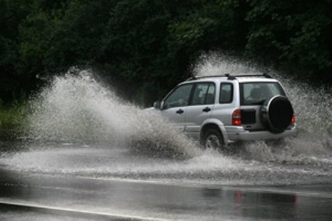
Hotter, More Humid Today. South wind at 10-15. Expect plenty of sun, dew points rising into the 63-67 range, falling barometer. We had two days of low humidity - now it's back to typical summer stickiness.
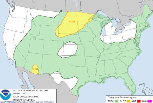
Severe Storms Northwestern Minnesota. SPC has all of northwestern and portions of central Minnesota in a "slight risk" of isolated severe storms late Monday. Fireworks may have to compete with some flashing & splashing, especially north and west of Brainerd and Detroit Lakes.
Thundery Tuesday:
the chance of T-storms will increase Tuesday; the latest NAM
model prints out .41" rain for the metro area Tuesday.
 Fireworks Trivia
. Who knew?
“The brilliance of fireworks is better in low humidity," says Dr. George Zambelli. "The higher humidity will cause the smoke to lay closer to the ground and appear more dense, and ultimately it will decrease the brilliance. The most brilliant fireworks are in low humidity when you have the winds carrying the smoke away from the spectators. In large displays you have a lot of pyrotechnic material going off at once, so you need something to dissipate that smoke.”

Tiny Camcorder Takes Wild Rides Aboard Exploding Fireworks. If you've ever wondered what fireworks look like, from the point of view of the fireworks themselves - here's your chance, thanks to
Mashable: "
You’ll probably be seeing lots of fireworks this weekend, but you won’t be experiencing them from this perspective, shot with a tiny spy camera strapped onto the fireworks themselves. Videographer Jeremiah Warren used an 808 #11 spy camera similar to the one pictured below. Despite its small stature (it’s a mere 2.6 inches long and 1.4 inches wide), the $120 camcorder can shoot and record HD in 720p."
Monday Severe Risk. The best chance of hail and damaging winds will come across the Dakotas and the northwestern half of Minnesota later in the day today. Stay alert for possible watches and warnings.
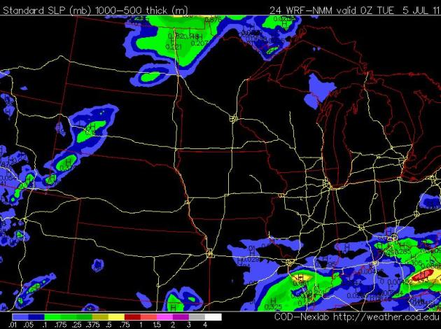
Monday Evening. Here is the NAM/WRF model, valid 00z Tuesday, or 7 pm this evening. Scattered T-storms are likely from the Red River Valley southward to Des Moines and St. Louis, numerous storms from the Carolinas westward to Huntsville and the Houston area, where rain would be most welcome right about now. Most of Florida should be dry, a few spotty (light) showers over Pennsylvania and New York State. A few orographic (instability) storms may pop up over the Rockies by evening, the west coast mostly-dry for fireworks.
Monday Evening Storms. The 00z NAM shows the best chance of strong/severe T-storms over the Red River Valley late Monday and Monday night. Dry weather will probably prevail into the evening hours for St. Cloud and the Twin Cities.
Winds: South 10-15.
Dew Points: 63-67 (it will feel stickier out there).
Barometer: falling.
Skies: Sunny to partly cloudy.
Rain: Storms possible later in the day over northwestern Minnesota. The immediate metro area probably won't see rain until late Monday night or Tuesday.
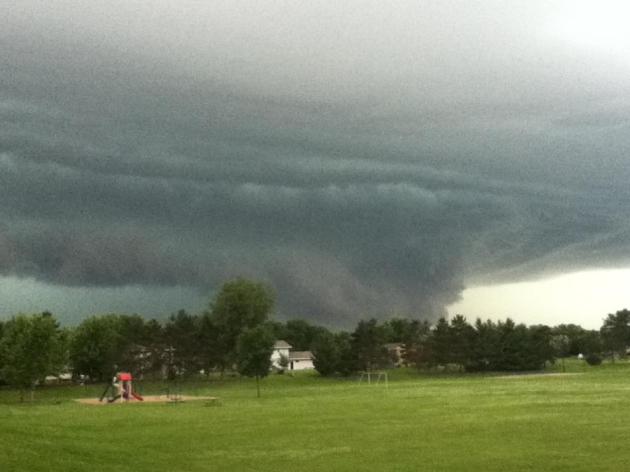 Wall Cloud
. WeatherNation meteorologist D.J. Kayser took this photo of a rapidly rotating supercell T-storm and a vivid wall cloud near Avon Friday evening. This is the storm that went on to produce a damaging downburst in St. Cloud and a small tornado in Waite Park.
PUBLIC INFORMATION STATEMENT
NATIONAL WEATHER SERVICE TWIN CITIES/CHANHASSEN MN
930 PM CDT SAT JUL 2 2011
...TORNADO IN WAITE PARK AND A DOWNBURST IN ST CLOUD...
THE NATIONAL WEATHER SERVICE ASSESSED THE DAMAGE CAUSED BY THE
STORMS FRIDAY EVENING JULY 1 IN EASTERN STEARNS COUNTY...INCLUDING
THE CITIES OF WAITE PARK AND ST CLOUD.
..................................................................
TORNADO LOCATION...THE TORNADO TOUCHED DOWN JUST NORTHEAST OF THE
INTERSECTION OF INTERSTATE 94 AND HIGHWAY 23. IT MOVED NORTHEAST
AND DISSIPATED IN WAITE PARK...ABOUT 1.5 MILES WEST OF THE
INTERSECTION OF HIGHWAYS 15 AND 23.
PATH LENGTH...2.3 MILES.
MAXIMUM WIND SPEED...ABOUT 65 MPH.
MAXIMUM WIDTH...APPROXIMATELY 30 YARDS.
TORNADO DAMAGE...DOZENS OF TREES WERE BROKEN OR TOPPLED AS IT MOVED
NORTHEAST. IT DID NOT APPEAR THAT THE TORNADO WAS CONTINUOUSLY ON
THE GROUND BUT THERE WERE FIVE DISTINCT LOCATIONS OF CONVERGENT
DAMAGE ALONG ITS PATH.
TIMING...IT APPEARS TO HAVE TOUCHED DOWN AT ABOUT 623 PM AND
DISSIPATED AT ABOUT 626 PM. THIS IS ESTIMATED BASED ON RADAR.
..................................................................
DOWNBURST LOCATION...MOST DAMAGE WAS NORTH OF DOWNTOWN ST CLOUD AND
WAS SPREAD OVER SEVERAL SQUARE MILES. IT EXTENDED INTO BENTON COUNTY.
DOWNBURST MAXIMUM WIND SPEED...65 TO 70 MPH.
DOWNBURST DAMAGE...HUNDREDS OF TREES WERE TOPPLED...BROKEN OR PUSHED
OVER. MANY TREES LANDED ON HOUSES...SHEDS AND VEHICLES. THE
DOWNBURST DAMAGE WAS FAR MORE WIDESPREAD AND SIGNIFICANT THAN THE
TORNADO DAMAGE.
DOWNBURST NOTES...IT IS LIKELY THAT THE DOWNBURST LASTED FOR MANY
MINUTES IN SOME AREAS.
OTHER DAMAGE...THERE WAS SPORADIC TREE DAMAGE FROM ROCKVILLE TO ST
CLOUD. THIS WAS MUCH LESS CONCENTRATED THAN THE WAITE PARK TORNADO
DAMAGE OR THE ST CLOUD DOWNBURST DAMAGE.
..................................................................
OTHER NOTES ABOUT DAMAGE SURVEYS OF THE JULY 1 STORMS... THE DAMAGE
IS SO WIDESPREAD ACROSS SO MANY COUNTIES IN THE CHANHASSEN FORECAST
AREA THAT IT IS NOT POSSIBLE TO LOOK AT EVERY BIT OF DAMAGE IN EVERY
LOCATION. THEREFORE SURVEYS IN THESE TYPES OF SITUATIONS ARE
TYPICALLY LIMITED TO THOSE AREAS WHERE DAMAGE OCCURRED AND SPOTTERS
REPORTED A FUNNEL OR TORNADO... OR WHERE DAMAGE OCCURRED COINCIDENT
WITH RADAR INDICATION OF A POSSIBLE TORNADO.
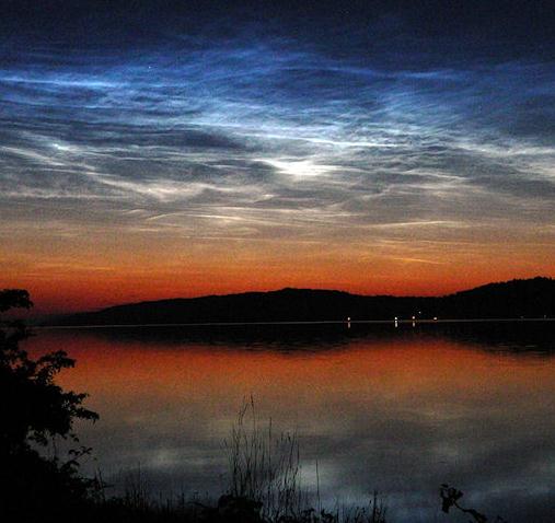
Photo Of The Day. Thanks to spaceweather.com for a spectacular example of "noctilucent clouds". These clouds form at dusk in the upper levels of the troposphere, possible the stratosphere. They are rare, mysterious, and on the increase - some climatologists theorize that climate change may be responsible for these clouds become more frequent with time: "
On July 1st and 2nd, a bank of rippling electric-blue noctilucent clouds spilled across the Canadian border into the lower United States. In doing so, the clouds made their farthest excursion of the year away from the Arctic, their usual environment. "These were the most brilliant NLCs I have ever witnessed!" reports Steven Rosenow, who sends this picture from Washington state."
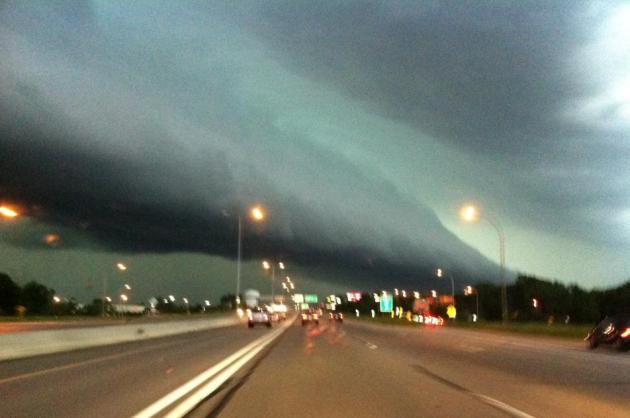
Second Photo Of The Day. OK, I was driving on I-394 Friday evening around 8 pm when I snapped this photo with my iPhone; that's why it's not in sharp focus. OK. I'm a lousy photographer. This is a "shelf cloud", marking the leading edge of a severe thunderstorm that swept into the metro area Friday evening, unleashing straight-line winds in the 50-70 mph range. I took this near Ridgedale, heading west, driving right into blinding rains and horizontal hail. Not smart.
June Climate Recap. Here's a
great summary of June weather for major cities around the state from the Chanhassen office of the National Weather Service: "
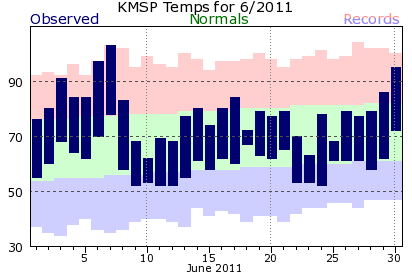
Temperatures for June 2011 were near normal for MN and WI and was characterized by a very warm first week and final two days, with near normal temperatures seen for the bulk of the month in between. June 2011 also marked the first time since November of 2010 that the Twin Cities officially had a month where the average monthly temperature was above normal. The warmest day this month was by far the 7th, when all three sites set new daily records when temperatures soared above the century mark, with 103 degrees observed at MSP, 101 degrees at STC, and 100 degrees at EAU. This was the first time in nearly five years that all three sites recorded a temperature of at least 100 degrees, with this last ocurring on July 31, 2006. For precipitation, the big story were the heavy rains seen in the Eau Claire area on the 18th into the 19th, when EAU picked up 4.84 of the months 7.23 inches of rain in about 4 hours. Another interesting aspect for June 2011 precipitation was the dryness noted across central MN (see precipitation departure map). Though St. Cloud officially had below normal precipitation for the month, the city itself was well above normal for rainfall on the month, as thunderstorms with torrential downpours that caused flooding in downtown St. Cloud on the 21st all but missed the official observation site at the airport just 5 miles to the east."
June Records. Yes, it was a month of wild extremes across the USA. From flood to drought, record chill to record heat, snow, fire, flood (and western snows). Am I missing anything here? No volcanoes - that's a good thing. Here are just a few of the many records set last month:
Miami Beach: Driest June on record 1.15”. Previous record 1.45”
Midland, TX: Highest average monthly temp 88. Previous 86.5 in June 1990. Previous highest overall (all months) 87.2 August 1964. Record no rain June 2011 in Midland. Old record 0.01 in June 2001
San Angelo, TX: Hottest average monthly temp 88.6. Old record 88.2
Philadelphia, PA: 9th warmest June on record 75.4
Atlantic City: 3rd warmest June 74.3
Alamosa, CO: Record dry June...only a trace
Louisville, KY: thru June 30th...2nd wesstest year @ 41.26”
Austin Mabry, TX: 2nd warmest June 87.1
Del Rio, TX: 3rd Warmest June 88.0
San Antonio, TX: 4th warmest June 86.2
Austin (Bergstrom): 4th warmest June 85.3
Smith, AR: Warmest June on Record 85
Wichita Falls: Warmest June on Record. Greatest number of days reaching 100 degrees...28
Tulsa, OK: 2nd Warmest June 84.4
Fort Smith, AR: record for most days at or above 90....30 days
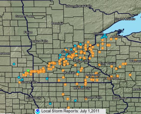
Friday Severe Recap. All those orange dots are reports of severe straight-line winds, the blue dots are reports of severe hail (as large as 2-4" in diameter!). You can see the "supercell" thunderstorm that tracked from near Marshall and Redwood Falls just north and west of the Twin Cities, dropping a tornado at Seaforth (west of Redwood Falls), spinning up funnels and possible tornadoes in the St. Cloud area. A second "bow echo" developed farther south, sweeping into the Twin Cities between 7:45 and 9 pm, producing straight-line winds in the 50-70 mph range. More from the
NWS: "
Severe thunderstorms rolled across Minnesota and Wisconsin during the afternoon and evening of July 1. There was a wide swath of wind damage from southwest Minnesota through western Wisconsin. In addition to the wind, some of the storms produced large hail up to the size to the size of baseballs. We anticipate sending a couple meteorologists out in the field on Saturday to survey some of the damage. There were a few unconfirmed reports of tornadoes with a couple of the storms that occurred."
From the Associated Press....
(On Sunday) GETTYSBURG, Pa. - A lightning strike at a camp of Civil War reenactors in Gettysburg, Pa., has sent five people to hospitals.
The Gettysburg Anniversary Committee says in a statement that during a severe thunderstorm at about 2:45 a.m. Sunday, lightning struck a tent pole in the Confederate artillery camp, resulting in moderate injuries to two people and minor injuries to three others. The five were taken to Gettysburg Hospital. One is in stable condition. Two others in stable condition were treated and transferred to York Hospital. Two others were treated and released. Reenactment officials say a tent-by-tent search of the site by staff and local fire departments turned up no other injuries. They say three small tents were damaged.
* Thanks for Chad Merrill at Earth Networks (formerly WeatherBug) for the article.
Fierce Storm Surprises Wisconsin Campers, Child Killed. Photo credit: "
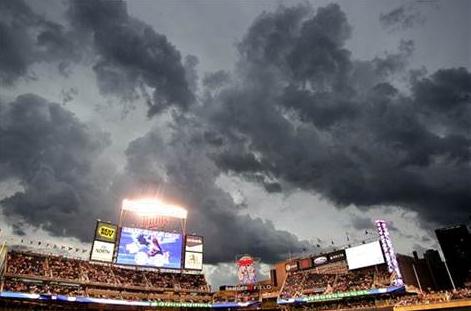
Storm clouds hover over Target field delaying the baseball game between the Milwaukee Brewers and the Minnesota Twins, Friday, July 1, 2011 in Minneapolis. (AP Photo/Andy King)"
MSNBC.com and AP have the details: "
GRANTSBURG, Wis. — A fierce thunderstorm swept through a rural Wisconsin county that was packed with holiday campers, toppling trees that killed an 11-year-old girl, blowing boats ashore and injuring more than three dozen people, officials said Saturday. The storm moved across Minnesota and Wisconsin on Friday, packing winds approaching 80 mph and hail as large as softballs. In northwestern Wisconsin's Burnett County, at least 39 people went to hospitals after the storm toppled hundreds of trees and left several thousand utility customers without power. Authorities said most of the injured were treated and released, but three were in critical condition Saturday evening. Heavy winds upended boats in the area and blew them ashore, while an airport hangar in neighboring Douglas County collapsed onto a single-engine plane. Searches were conducted The storm came at one of the worst times of the year for rural Burnett County: a summer holiday weekend, when the area's lakes and rivers attract tens of thousands of visitors, said Rhonda Reynolds, a regional director for Wisconsin Emergency Management."
June Recap: Cooler North, Warmer South. Dr. Mark Seeley, author of
WeatherTalk, has a summary of June in Minnesota - wetter statewide, but temperatures were all over the map: "
June average temperature values were mixed. Many observers in the north and central counties reported values that were 1 to 2 degrees colder than normal, while most of those in southern and western Minnesota reported values that were 1 to 2 degrees F above normal. Extreme values ranged from 103 degrees F at MSP on June 7th to just 26 degrees F at Embarrass on June 2nd. June rainfall was generally above normal for most observers, though a number across central Minnesota reported below normal rainfall. For many June brought 5 or more inches of rainfall, while some received 150 to 200 percent of normal. Several individual observers reported record-setting daily rainfall amounts over June 14-18,including some amounts over 4 inches. Some of the highest monthly totals around the state were:"
Lamberton 8.44 inches
Cook 7.92 inches
Faribault 7.91 inches
Lake City 7.89 inches
Rushford 7.57 inches
La Crescent 7.16 inches
Theilman 6.61 inches
Too Dry For Fireworks? According to the Wall Street Journal: More fires are reported on July 4 than on any other day in a typical year, and fireworks account for more than half the fires, according to the National Fire Protection Association. Fireworks caused an estimated 18,000 fires during 2009, the most recent year reported, leading to 30 civilian injuries and $38 million in property damage, the association said.
In Oklahoma, 36 counties suffering from extreme to exceptional drought have issued burn bans, which include a prohibition on fireworks except for public displays.
In Kansas, fireworks have been banned in Dodge City and surrounding rural areas due to the extreme drought.
In Louisiana, fireworks have been banned in Shreveport and neighboring Bossier because of extreme heat and drought.
In Texas, 170 counties have fireworks bans, including all of metropolitan Houston. Nearly all of Texas has burn bans as well. Because of the extreme drought, Fourth of July fireworks displays have been canceled in Texas towns large and small: San Antonio, Austin, Amarillo, Lubbock, Plainview, Magnolia, Tomball, DeSoto, Woodlands, Roman Forest, and Patton Village.
In Arizona, authorities have banned fireworks from Flagstaff in the north to Tucson, Douglas and Sierra Vista in the south.
In New Mexico, Gov. Susana Martinez (R-NM) has said that there is “absolutely no reason to buy, sell or use personal fireworks.” She has declared a “state of emergency in New Mexico regarding the use of fireworks.” Albertson’s, WalMart, and Smith’s stores have stopped selling fireworks in the state. Taos, with wildfires raging nearby, has canceled its fireworks display.
In Joplin, Missouri, where a devastating tornado hit on May 22, officials have banned fireworks because of the amount of combustible debris in the tornado’s path.
In Massachusetts, the historical recreation site Old Sturbridge Village has canceled its fireworks display because its fireworks launch site was flooded and alternative launch sites were damaged by tornadoes.
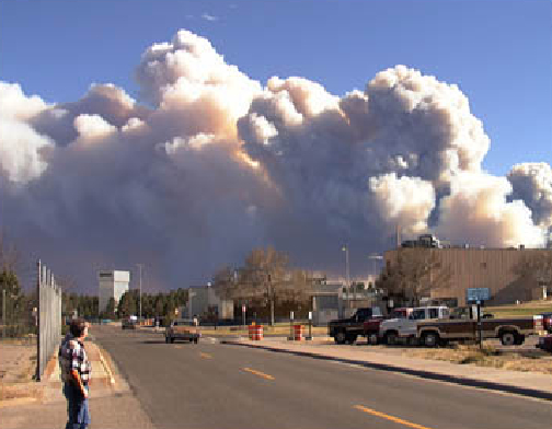
Los Alamos Blaze Now Largest In New Mexico History. The "Las Conchas" fire has charred over 121, 000 acres, making it the largest in New Mexico history.
NASA is monitoring carbon monoxide levels from low-orbit. Why?
"Detecting nitrogen dioxide is important because it reacts with sunlight to create low-level ozone or smog and poor air quality. The fire has blackened more than 162 square miles in the last six days, making it the largest fire in New Mexico history. Erratic winds and dry fuels helped it surpass the 2003 Dry Lakes fire, which took five months to burn through 94,000 acres in the Gila National Forest. The Los Alamos National Laboratory remained closed, and fire officials said there was no chance the thousands of evacuated residents and lab employees would be able to resume their normal lives Friday."
Latest on Las Conchas:
Size: 121,248 acres
Percent Contained: 11%
Resources: 18 Helicopters; 72 Engines; 26 Water Tenders; 8 Dozers
Total Personnel: 1,995
Residences: 450 threatened; 63 destroyed
Outbuildings: 140 threatened; 32 destroyed
Injuries to Date: 4
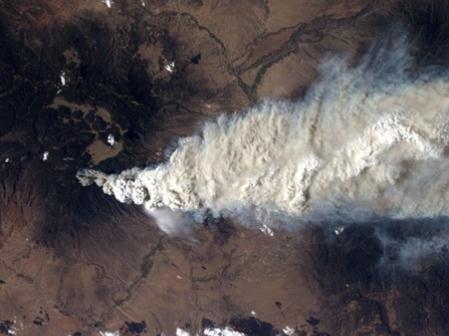
More On Las Conchas Fire. The Washington Post's
Capital Weather Gang has the story. So far, in just the last 2 weeks, both Arizona and New Mexico have experienced their largest respective fires in state history. Photo above:
"A crew member aboard the International Space Station, flying at an altitude of approximately 235 statute miles on June 27, 2011, exposed this still photograph of a major fire in the Jemez Mountains of the Santa Fe National Forest in north-central New Mexico. The fire is just southwest of Los Alamos National Laboratories. (NASA) The Las Conchas wildfire burning along the western edge of Los Alamos National Laboratory in New Mexico has grown to more than 103,800 acres (according to the Associated Press), making it the largest forest fire in New Mexico history. This new record has been set less than month after the Wallow fire in Arizona became the largest in state history, burning more than 470,000 acres. And firefighters have responded to nearly 1500 wildfires in Texas this year, which have burned a record3.3 million acres. The old Texas record was 1.98 million acres in 2006 (records have been kept for 25 years) according to Amarillo.com."
Record Heat On Saturday:
Phoenix, AZ: 118 *hottest day in Phoenix since July 21 2006 when it was 118.
Longview, TX: 104
Joplin, MO: 103
Monroe, LA: 102
New Orleans: 100
New Iberia, LA: 100
Toledo, OH: 98
Tucson, AZ: 111
In Stark Contrast:
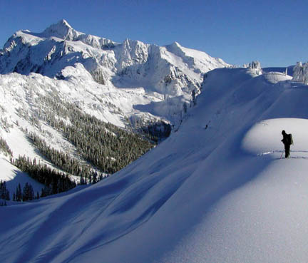
Road To Artist Point (Washington) Buried Under 50 Foot Drifts. Snow 50 feet deep still buries the road (State Route 542) to Artist Point at Mount Baker and will keep the upper portion of the road closed all summer. “This is the deepest snow I’ve seen since the world-record year 1999, when the highway didn’t open for the summer.” WSDOT will forgo clearing the last two miles of snow-covered highway to the upper parking lot because the snow is simply too deep and would take too long to clear. The work would tie up maintenance crews for the next two months when they could be working on other state priorities like fixing potholes, signs and guardrail. “The restroom in the upper parking lot is nowhere to be seen. The road to Artist Point is 2.7 miles long and more than 5,000 feet above sea level, and is typically buried under snow and closed October through June. In recent years, it has usually opened in July.
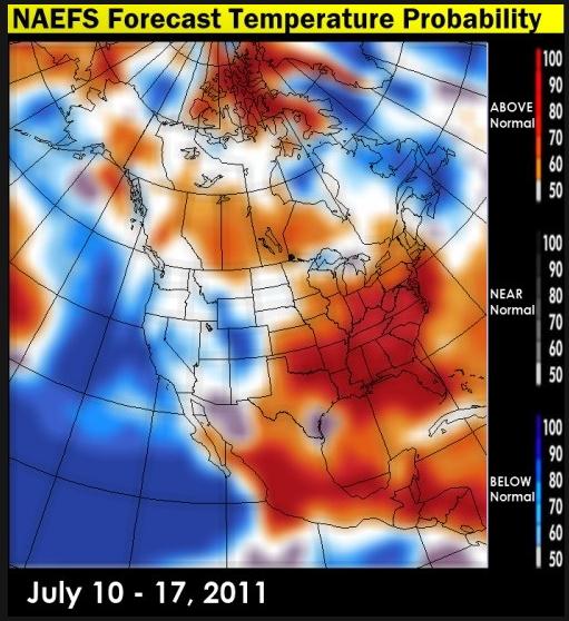
Growing July Heatwave. Map above courtesy of Environment Canada. Meteorologist Larry Cosgrove has some insights into the unfolding weather pattern in his
WEATHERAmerica newsletter at examiner.com. Looks like Minnesota will be on the northern edge of a massive heatwave that will cover much of America through mid July, stretching from the Plains to the East Coast.
Warmer, Wetter Climate Is The "New Normal". The
Star Tribune's Bill McAuliffe has a story about the (new) 30-year normals, a .5 F. warming trend in just the last 10 years; a 2-3 F. warming trend for the northern third of the USA since 1970. More details: "
It may not be enough to make you cancel that midwinter trip to Arizona, but a warmer January is now "normal" for the Twin Cities. January nights here warmed more markedly than any other part of the year in the once-a-decade update of climate "normals" by the National Oceanic and Atmospheric Administration (NOAA). All 12 months saw an increase in the normal low temperature, but January's 3.2-degree rise was emphatic and double the next-steepest increase, according to the report released Friday. Normal highs, meanwhile, rose for nine of 12 months in the Twin Cities. January's 1.8-degree jump also led that category. Does this mean milder winters are now normal for the Twin Cities? "Absolutely," said Mark Seeley, University of Minnesota Extension climatologist and Minnesota climate historian."
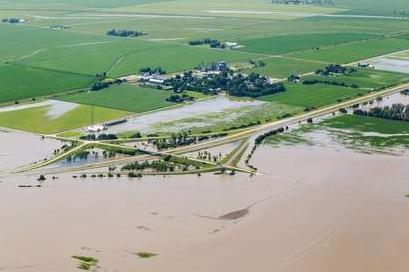
Breach Brings Flood To Percival (Iowa). An update from
omaha.com: "
PERCIVAL, Iowa — At 10 a.m. Thursday, this unincorporated town of 87 people was mostly dry, except for the ditches. By noon, the Missouri River ran through the streets — a foot deep in some places — with the few remaining residents scrambling into pickups and sloshing out of town. Floodwaters rushed into Percival after a nearby levee broke in the early morning hours. The water worked its way through farm fields, over rural roads and into town. Fremont County's emergency manager expects the town eventually to be swamped under 10 feet of water, based on Army Corps of Engineers estimates, and that the water will rush south until it hits the new levee at Hamburg. “The long, slow wait is over,” said Charlie Bohlen, owner of Bohlen's Farm Service as muddy, shimmering water filled cracks in the pavement of a street near his store. Percival is about 16 miles northwest of Hamburg, where a secondary levee was built in June. “From north of Percival to Hamburg, everything is pretty much downhill,” said Mike Crecelius, Fremont County's emergency manager. “At the rate this is going, from (Percival) south, we are probably going to end up with water from the river to the bluff.”
Flood Turns Minot Housing Shortage Into Crisis. The
AP has the story: "
MINOT, N.D. (AP) — Workers in North Dakota's booming oil industry and related jobs had taken up any empty space in Minot before the swollen Souris River raced into the city, filling thousands of homes with water and turning the housing shortage into a crisis. Housing is tight across the state's oil patch, with some workers in far-flung areas living in cars, campers and hotels. In Minot, the biggest city near the state's oil patch, new construction enabled people to find a roof to put over their heads. More than 1,000 apartments and 600 homes were built in the past three years. But the flood that drowned some 4,100 homes last week destroyed those gains and set the city back. Many people are now living in vans, sleeping in tents and staying at shelters. Even more have bunked up with friends or relatives. "We were already in a major building mode and desperately trying to catch up to the oil boom before the flood and this is going to make it worse," said Darrell Linnertz, Minot's building inspector for the past two decades. "This will make the housing shortage almost ridiculous — people are going to have to live anywhere they can." The flood broke a more than 130-year-old record for high water. In some cases, the river reached the eaves of homes. A Federal Emergency Management Agency survey done by airplane found about 800 houses covered by more than 10 feet of water and 2,400 under at least 6 feet. For most residents, that means they've lost anything on their first floor and in finished basements, which are common."
Mega-Zap. Thanks to T-Storm Weather LLC for passing along a photo of cloud to ground lightning lighting up the sky over Chicago Thursday night.
PUBLIC INFORMATION STATEMENT
NATIONAL WEATHER SERVICE LUBBOCK TX
1111 AM CDT FRI JUL 1 2011
...JUNE 2011 WAS THE HOTTEST MONTH ON RECORD FOR LUBBOCK TEXAS...
THIS MAY NOT COME AS NEWS TO ANYONE WHO HAS ENDURED THE RECENT HEAT
WAVE OVER THE SOUTHERN PLAINS OF WEST TEXAS...BUT TEMPERATURES AT
LUBBOCK TEXAS FOR THE MONTH OF JUNE WERE THE HOTTEST EVER RECORDED...
AVERAGING 85.9 DEGREES. THIS BROKE THE ALL-TIME RECORD FOR THE HOTTEST
MONTH EVER AT LUBBOCK...PREVIOUSLY 85.4 DEGREES FROM JULY OF 1966.
THE HIGHS FOR THE MONTH OF JUNE 2011 AT LUBBOCK ALSO WERE THE
HOTTEST EVER RECORDED OVER AN ENTIRE MONTH...AVERAGING 100.8 DEGREES.
THIS BROKE THE PREVIOUS RECORD OF 99.5 DEGREES SET IN AUGUST 1943.
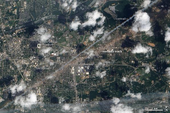
2011 Spring Tornado Outbreaks.
NSSL has a very good summary of the incredible spring for tornado outbreaks around the USA. Photo credit above: Tuscaloosa, AL, May 2, 2011 — On April 27, 2011, a devastating tornado tore through Tuscaloosa, Alabama. The storm packed winds of 190 mph and left a path of debris running southwest to northeast. On May 2, 2011, the Advanced Land Imager (ALI) on NASA’s Earth Observing-1 (EO-1) captured this natural-color image of the tornado track through Tuscaloosa. Credit: NASA Earth Observatory. The tornadoes that occurred during the spring of 2011 were deadly, record-breaking, and heart-breaking. Below we have listed the most significant outbreaks so far this year, along with links and information, and some of NSSL's research products that have been used in assessing the outbreaks. We will update this page as numbers become confirmed.
April 14-16, 2011
At least 200 tornadoes were confirmed across 16 states killing an estimated 38 people. The three-day outbreak spread from the Great Plains on the first day, to Mississippi and Alabama the second, then swept through the Carolinas and Virginia on the third.
April 27-28, 2011
The April 27-28 tornado outbreak will go on record as the deadliest two-day period for tornadoes since 1936. More than 300 people were killed in Mississippi, Alabama, Georgia and Tennessee by an estimated 305 tornadoes. The outbreak of tornadoes began during the early morning of April 27 and ended during the early morning hours of April 28.
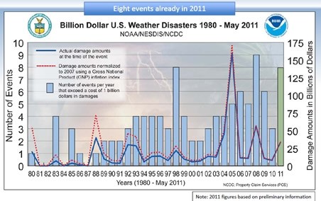
8 Separate Billion Dollar Disasters So Far In 2011. The story from NOAA and
The Weather Channel: "
Welcome to July and the second half of the year! Let's hope the atmosphere is much more benign during the next six months compared to what we've experienced during the past six months. The events that have occurred during the first half of the year have been astonishing. According to the National Oceanic Atmospheric Administration (NOAA), we've already seen eight billion-dollar weather disasters since January! This is an unbelievable number of events of this magnitude crammed into just six months. For perspective, the most billion-dollar weather disasters recorded in one full year (since 1980) is nine in 2008. This was from a wide variety of weather events including tornadoes, floods, drought, wildfires and three hurricanes. With half the year and the peak of the hurricane season ahead of us, it's not out of the question that this undesirable record could be reached in 2011."
March 11 Tsunami Was A Record 40 Meters High. This is incredible - that's over 120 feet, an eight-story building. Good grief. Details from
NHK: "
Japan's Meteorological Agency and researchers have found that the tsunami of March 11th reached heights of up to 40 meters. The precise height of the waves was not clear because automatic tide-gauge stations were destroyed and blackouts and communication failures occurred at the time of the disaster. Experts have looked into traces of each tsunami in the affected area and found that around 10-meter waves reached wide areas of Iwate, Miyagi and Fukushima Prefectures. They also found tsunami reached up to 40.5 meters in Miyako City in Iwate Prefecture, 37.8 meters in Noda village also in Iwate Prefecture, and 34.7 meters in Onagawa town in Miyagi prefecture."
How Much Does A Hurricane Cost? AccuWeather has some estimates: "
$1.8 billion (2011 adjusted) is the median amount of damage caused by an Atlantic hurricane that hits land in the United States. The median cost is the most accurate measure of the middle of the data because Hurricane Katrina's immense damage, at $145 billion (2011 adjusted), inflates the average cost of a hurricane to close to $9 billion. Take a look at the numbers: estimated damage in billions from hurricanes that directly hit the United States from 1980 to 2010. You can read the data and comment on Scribd."
 Ultimate Dog Tease
. There are no words to describe this. My sister, Joan, turned me on to this
YouTube clip. If you love dogs you'll get a kick out of this - even if you don't like dogs you'll enjoy this video. That's my prediction.
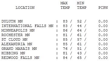
Extraordinary Sunday. I didn't think the weather could get any better than Saturday. I was wrong - yesterday was a day that would make the Minnesota Chamber of Commerce proud. Yes, the State of Minnesota may be shut down - but Mother Nature seemed to show some well-timed mercy in the weather department. Under a flawless, squint-worthy blue sky the mercury rose to a very respectable 83 at Duluth, 85 at St. Cloud and 86 in the Twin Cities. Even normally-chilly Grand Marais got in on the meteorological fun, recording a high of 76.
Cabin Therapy
"Hi, my name is Paul. I have 'Internet-itus'. I can't stop checking e-mail, texts, posts, tweets & pokes. Please help me." Having any better luck disconnecting? Yes, technology was supposed to set us free, make us more efficient, liberating us from the tyranny of paper products. Instead it's turned us into Internet Zombies, clicking 24/7 for our Pavlovian, digital-dopamine reward. In theory the cabin should be an Internet-free zone. I'm on "vacation", which means I'm taking a holiday from being plugged into The Matrix. All true, but I still hate the idea of missing something. "Honey, you're here, but you're not really HERE!" my wife complains. Hope you're having better luck with your Internet-addiction. Ugh. Nasty habit.
What a 4th of July weekend. For once we were the beneficiaries of a well-timed bubble of Canadian high pressure. The Doppler will be collecting dust much of today: hot, 90-degree sunshine; storms likely over the Red River Valley of northwestern MN, where a few storms may turn severe later. A south wind turns up the humidity; drippy dew points rising through the 60s, but no atmospheric firecrackers expected in the immediate metro area. We lucked out. A well-deserved break. Time to turn off the laptop and ignore my e-mails. Sorry.
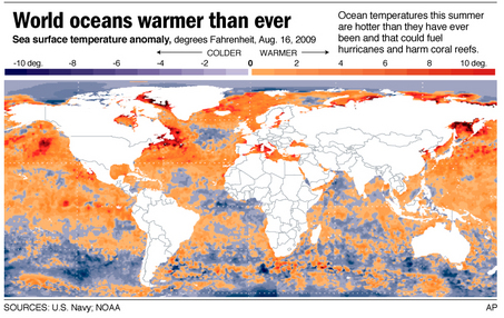 Warming Ocean Could Melt Ice Faster Than Thought
. A Sunday article from
NPR: "
Warming air from climate change isn't the only thing that will speed ice melting near the poles — so will the warming water beneath the ice, a new study points out. Increased melting of ice in Greenland and parts of Antarctica has been reported as a consequence of global warming, potentially raising sea levels. But little attention has been paid to the impact of warmer water beneath the ice. Now, Jianjun Yin of the University of Arizona and colleagues report the warming water could mean polar ice melting faster than had been expected. Their report was published Sunday in the journal Nature Geoscience. While melting floating ice won't raise sea level, ice flowing into the sea from glaciers often reaches the bottom, and grounded ice melted by warm water around it can produce added water to the sea. "Ocean warming is very important compared to atmospheric warming because water has a much larger heat capacity than air," Yin explained. "If you put an ice cube in a warm room, it will melt in several hours. But if you put an ice cube in a cup of warm water, it will disappear in just minutes." In addition, Yin explained, if floating ice along the coastal areas melts it will allow the flow of glaciers to accelerate, bringing more ice into the seas. "This mean that both Greenland and Antarctica are probably going to melt faster than the scientific community previously thought," co-author Jonathan T. Overpeck said in a statement."
Extreme Weather And Climate Science. The
ABC Network in Australia has an eye-opening interview with climate scientist Kevin Trenberth: "
One of the world's leading climate scientists, Kevin Trenberth, explains what's causing recent wild weather and why he has no doubt that humans are contributing to the increased incidence and severity of these weather events. He'll be speaking at the Earth on the Edge conference in Melbourne later today which has brought together more than 4,000 earth scientists and experts from more than 100 countries."
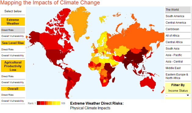
Global Interactive Map Of Climate Change Impact. Here's an interesting article from
Humanosphere: "
The Center for Global Development has created a great interactive map illustrating the relative impact of climate change on nations. The map is based on data predicting impacts caused by extreme weather events, sea level rise, agricultural productivity losses and overall rankings. No single nation ranks high risk in all categories. But clearly, Africa, India and other parts of Asia are predicted to fare the worst. Go to the link above to use the interactive map and. This is just a screen grab."


No comments:
Post a Comment