* Potential for large hail, damaging straight-line winds, even an isolated tornado.
* Strong/severe storms may rumble into metro area after 9 or 10 pm.
* Sunday: frontal boundary lingers over southern MN - best chance of PM storms south/west of the metro area.
* Monday: low 90s, dew points in the low to mid 70s, may feel like 100-105 (with another round of potentially severe storms).
* Some late-week relief: highs in the mid 80s the latter half of next week.
BULLETIN - IMMEDIATE BROADCAST REQUESTED
SEVERE THUNDERSTORM WARNING
NATIONAL WEATHER SERVICE EASTERN ND/GRAND FORKS ND
511 PM CDT SAT JUL 30 2011
THE NATIONAL WEATHER SERVICE IN GRAND FORKS HAS ISSUED A
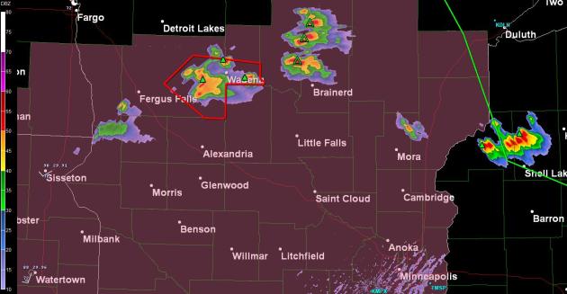
* SEVERE THUNDERSTORM WARNING FOR...
EASTERN OTTER TAIL COUNTY IN WEST CENTRAL MINNESOTA...
SOUTHERN WADENA COUNTY IN CENTRAL MINNESOTA...
* UNTIL 615 PM CDT
* AT 510 PM CDT...NATIONAL WEATHER SERVICE DOPPLER RADAR INDICATED A
SEVERE THUNDERSTORM CAPABLE OF PRODUCING QUARTER SIZE HAIL...AND
DAMAGING WINDS IN EXCESS OF 60 MPH. THE STORM WAS LOCATED 4 MILES
WEST OF DEER CREEK...OR 32 MILES EAST OF FERGUS FALLS...MOVING TO
THE EAST AT 25 MPH.
* THE SEVERE THUNDERSTORM WILL BE NEAR...
DEER CREEK AROUND 520 PM CDT.
BLUFFTON AND ALMORA AROUND 525 PM CDT.
WADENA AND PARKERS PRAIRIE AROUND 535 PM CDT.
WRIGHTSTOWN AROUND 540 PM CDT.
THEREAFTER SOME OTHER LOCATIONS IMPACTED BY THE SEVERE THUNDERSTORM
INCLUDE VERNDALE...ALDRICH AND STAPLES AIRPORT.
PRECAUTIONARY/PREPAREDNESS ACTIONS...
REMEMBER SEVERE THUNDERSTORMS CAN AND OCCASIONALLY DO PRODUCE
TORNADOES WITH LITTLE OR NO ADVANCE WARNING.
No comments:
Post a Comment