84 F. high in the Twin Cities Tuesday, before the deluge arrived.
16 days/row above 100 at Houston (a new all-time record).
39 nights above 80 (for lows) at Dallas, tying the all-time record set in 1998).
80 days above 100 so far this summer season at Wichita Falls, Texas.
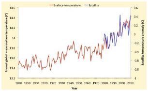
7th Warmest July On Record Worldwide. Since January 1 worldwide temperatures over land have been running about 1.4 F. warmer than the 20th century average, the 8th warmest such period on record. More details from NOAA below.
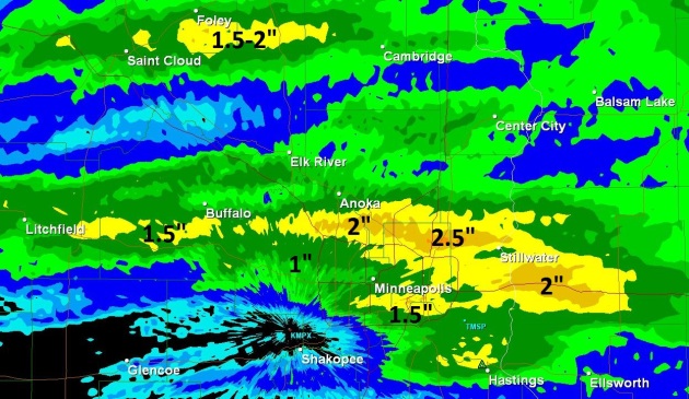
Tropical Downpour. A slow-moving cool frontal boundary squeezed out 2-3" week's worth of rain from St. Cloud to the northern suburbs of the Twin Cities Tuesday night. Amounts ranged from under .25" near Shakopee to as much as 2-2.5" from Coon Rapids and Brooklyn Park to Shoreview and White Bear Lake.
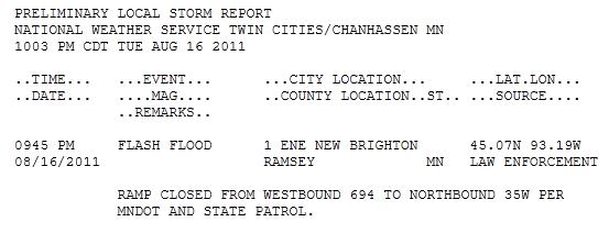
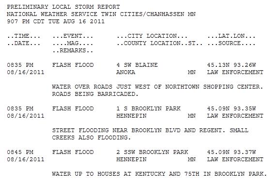
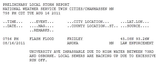
Flash Flood Reports. To the National Weather Service's credit - they did issue a Flash Flood Warning for much of the metro 2-4 hours before the heaviest rains soaked the north metro, resulting in considerable street and stream flooding from Fridley to Brooklyn Park to Blaine. The complete run-down is here.

Photo Of The Day. Here's an amazing photo, courtesy of the Washington Post's Capital Weather Gang: "This may well be a first: NASA astronaut Ron Garan photographed a shooting star blazing through the Earth’s atmosphere from the International Space Station. He captured the image on Friday - around the time the Perseid meteor shower was peaking, and also, coincidentally, not long before we could see the International Space Station making a pass over our skies. Garan posted the picture on Twitter for the world to see. Cool stuff."
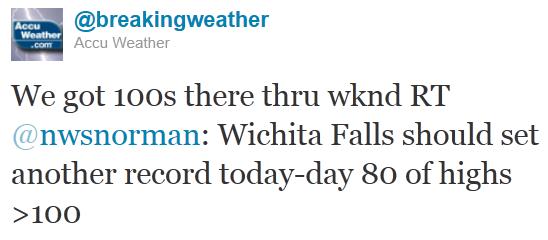
- Houston, TX reached 100+ Tuesday, marking the 16th consecutive 100+ day. #2 on the list is 14 days in 1980.
- Wichita Falls, TX surpassed 100+ Tuesday, breaking the record for the number of 100+ days in a calendar year at 80 days. Previous record, 79 days in 1980.
- Waco, TX hit 100+ Tuesday, marking the 64th day of 100+ highs, breaking the previous record of 63 in 1980.

Sizzling South - Comfortable North. 100-degree heat continues to grip the southwest and the Southern Plains state - another searing day for Texas and Oklahoma, while comfortable 70s are the rule from Minnesota and the Great Lakes into northern New England, comfortable 60s for the Pacific Northwest.

Puddle Potential. A cool front sparks scattered showers and T-storms from the Great Lakes southward to Chicago and Louisville, more T-storms producing local downpours south of Orlando, Florida, a few strong/severe storms over the Front Range of Colorado. Most of the east coast enjoys a pleasant, sunny day with reasonable humidity levels, blue sky the rule west of the Rockies.
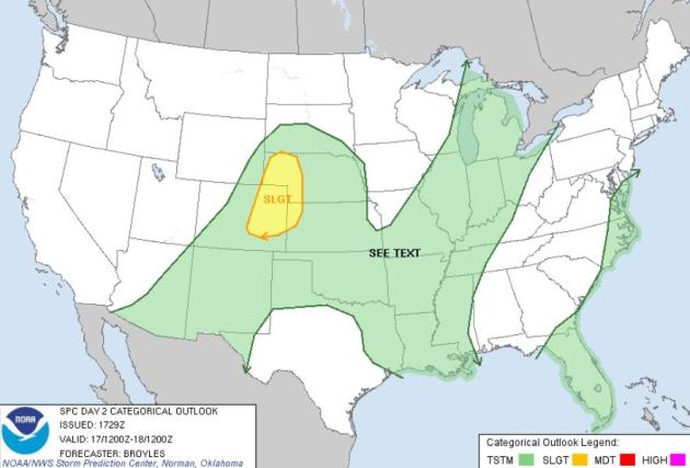
Wednesday Severe Threat. Things simmer down a bit today; SPC is predicting a slight risk of severe storms from Colorado Springs and Denver into western Nebraska.
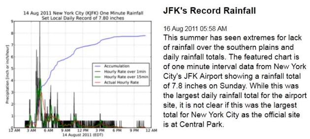
Record 24 Hour Rainfall In New York? Central Park is the official reporting station for New York City, but JFK's 7.8" rainfall amount on Sunday is certainly in record-territory. Data courtesy of the Iowa Environmental Mesonet.
Rainfall Amounts From Sunday Thru Tuesday Evening:
- New York City, NY 7.81”
- Newark, NJ 6.74”
- Bridgeport, CT 3.17”
- Worcester, MA 2.47”
- Concord, NH 2.24”
- Providence, RI 2.23”
- Atlantic City, NJ 2.14”
- Poughkeepsie, NY 1.57”
- Rochester, NY 1.21”
- Allentown, PA 0.67”

Showers Remain But Record Rains Move On. Seattlepi.com has more details on the record flooding that swept across the New York City area: "NEW YORK (AP) — It's over for now: the flooded roads, overflowing streams, swimming-pool basements and sodden ground. The National Weather Service says despite thunderstorms and showers on Monday, we have moved past the torrential rains. We've seen the worst of it, weather service spokesman John Cristantello in New York said early Tuesday. The storm dropped record rains over the weekend on parts of the nation's eastern half, washing out roads in New Jersey and forcing a small hospital in Ohio to move patients. Nearly 8 inches of rain fell on New York City's Kennedy Airport on Sunday and nearly 5 in Philadelphia, setting city records for any day. At Seabrook Farms, N.J., the daily total was nearly 11 inches. The effects still were being felt a day later."
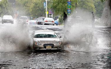
Rain Ending, Officials Assess Flood Damage In New Jersey. NJ.com has more details on the recent severe flooding across New Jersey, some 3-6" amounts reported: "Officials are assessing damage as the heavy rain that drenched parts of New Jersey end today. A flood warning remains in effect for urban areas and small streams in southeastern Salem, Cumberland and Atlantic counties. Forecasters say the Maurice River is more than 2 feet above flood stage and appears to be the second highest stage in the river's history dating to 1940. Forecasters say it may take another day before it falls below flood stage."
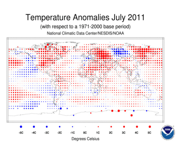
Global Temperatures Were 7th Warmest On Record For July. NOAA has the details: "The globe experienced its seventh warmest July since record keeping began in 1880. July’s Arctic sea ice extent was the smallest on record for that month since records began in 1979.
Global Temperature Highlights: Year to date
- The combined global land and ocean average surface temperature for the January – July period was 0.92 F (0.51 C) above the 20th century average of 56.9 F (13.8 C), making it the 11th warmest such period on record. The margin of error is +/- 0.16 F (0.09 C).
- The January – July worldwide land surface temperature was 1.40 F (0.78 C) above the 20th century average — the eighth warmest such period on record. The margin of error is +/- 0.36 F (0.20 C). Warmer-than-average conditions were prevalent across most of Russia, the Middle East, northern Africa, Europe, the southern United States, and Mexico. Cooler-than-average regions prevailed over the northwestern United States, southwestern Canada, and most of Australia.
- The global ocean surface temperature for the year to date was 0.74 F (0.41 C) above the 20th century average and was the 11th warmest such period on record. The margin of error is +/-0.07 F (0.04 C). The warmth was most pronounced across the Labrador Sea, most of the central and western Pacific, the equatorial Atlantic, and much of the mid-latitude southern oceans.
- Neither El Niño nor La Niña conditions were present during July 2011. According to NOAA’s Climate Prediction Center, ENSO neutral conditions are expected to continue into the Northern Hemisphere fall 2011, with an equally likely chance of ENSO-neutral or La Niña conditions thereafter."
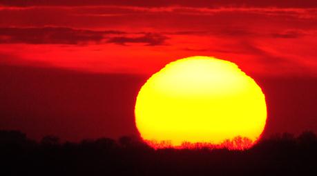
Remarkable heat in Asia. Here is an excerpt of a post from Jeff Masters at Weather Underground, documenting extreme heat across Asia in recent months: "For the second consecutive summer, some of the hottest temperatures in Earth's recorded history have scorched Asia. The five hottest (undisputed) temperatures ever measured in Asia have all occurred in during the past two summers:
1) 53.5°C (128.3°F) at Moenjodaro, Pakistan on May 26, 2010
2) 53.3°C (127.9°F) at Mitrabah, Kuwait on August 3, 2011
3) 53.1°C (127.6°F) at Sulaibiya, Kuwait on June 15, 2010
4) 53.0°C (127.4°F) at Tallil, Iraq on August 3, 2011
4) 53.0°C (127.4°F) at Dehloran, Iran on July 28, 2011"

Redefining The Meaning Of HOT. Jeff Masters at the Weather Underground has a post about global hot weather records, and the validity/accuracy of some of these measurements - along with some eye-popping accounts of hot weather (many caused by "heat bursts"):
"188° (86.7°C) June or July, 1967 Abadan, Iran (heat burst)
SOURCE: News clip, no further info available. See Extreme Weather; A Guide and Record Book, by Christopher C. Burt, 2007, for more information on this event.
NOTES: This surely is an apocryphal record. The highest official temperature during the months of June or July 1967 at Abadan was 48.9°C (120°F) on July 15. Not an unusual temperature for this area at this time of the year.
VALIDITY SCORE: 0
Let.s think a moment just what kind of thermometer could have registered 188°F. An oven thermometer?
158° (70.0°C) July 6, 1949 near Lisbon, Portugal (heat burst)
SOURCE: News clip, no further info available. See Extreme Weather; A Guide and Record Book, by Christopher C. Burt, 2007, and Freaks of the Storm, by Randy Cerveny for more information on this event.
NOTES: The news reports of this event at the time claim this reading was made in the sun not shade. So it cannot be considered a reliable figure.
VALIDITY SCORE: 1
Well something amazing happened here this day but, again, just what kind of thermometer registers up to 158°F?
152° (66.7°C) July 10, 1977 Antalya, Turkey (heat burst)
SOURCE: News clip, no further info available. See Extreme Weather; A Guide and Record Book, by Christopher C. Burt, 2007, for more information on this event.
NOTES: The official maximum temperature at Antalya on July 10, 1977 was 43°C/109.4°F (and for that month 44°C/111.2°F on July 16). There is no reliable record concerning this 152° figure.
VALIDITY SCORE: 0
No evidence physical or otherwise about this event."
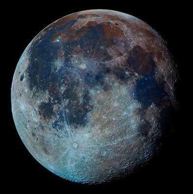
Astronomy Photographer Of The Year 2011 Shortlist - In Pictures. If you're an astronomy-buff you may enjoy this photo essay from the U.K. Guardian: "Judging is under way for the Astronomy Photographer of the Year 2011. These are some of the shortlisted entries. Winners will be announced on 8 September and will go on display the following day at the Royal Observatory, Greenwich. The exhibition is free and will run until February 2012."

Breaking News: Kansas Is Actually Flatter Than A Pancake. Nice to know scientists are focusing on important issues. Good grief. Geekosystem.com has the "story": "As the old saying goes Kansas, like many midwestern states, is as flat as a pancake. Somehow, pancakes became the golden standard for flatness, but do they really deserve such a title? A team of researchers from Texas State University and Arizona State University decided to find out. The researchers scientifically tested whether or not the state of Kansas was as flat as a pancake, and were surprised at what they found. Pancakes might be flat, but they are by no means the golden standard. The state of Kansas is actually flatter than a pancake. Who would have thought that was possible? The researchers figured this out by gathering data from the US Geological Survey about the topography of Kansas. They then obtained sample pancakes from none other than that breakfast staple, The International House of Pancakes. Armed with science and breakfast, the researchers headed into the lab. The researchers used a confocal laser microscope to compare the flatness quotient of a pancake to the USGS data about Kansas. For something to be perfectly flat (1.0) it would need to have no two points on its surface at different levels. A 2cm strip of pancake was placed under the microscope, and the researchers found that it was surprisingly inconsistent (0.957) with some sharp peaks and a lump in the center. Kansas, on the other hand, was pretty darn close to the perfectly flat designation, coming in at 0.9997. According to the researchers, this makes the state flatter than a pancake."
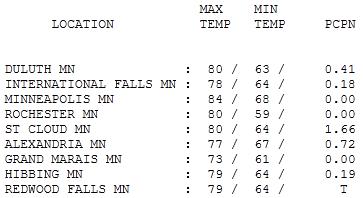
Partly Sunny With A Risk Of A Tropical Downpour. Most of the day was just fine, but a slow-moving cool front sparked a band of heavy rain (and frequent lightning) by late afternoon and evening. St. Cloud picked up a whopping 1.66" as of 7 pm, some 1-3" amounts around the Twin Cities. Highs ranged from 73 at Grand Marais to 80 at St. Cloud, 84 in the Twin Cities.

"Corona". Why am I suddenly so thirty? I snapped this photo last Friday night as mid-level clouds shrouded the moon, creating a splash of color around the moon, a corona.
Paul's Conservation Minnesota Outlook for the Twin Cities and all of Minnesota:
TODAY: Comfortable sunshine, breezy and less humid. Dew point: 54. WInds: NW 10-15. High: 78
WEDNESDAY NIGHT: Mostly clear and comfortable. Low: 59
THURSDAY: Less sun, T-showers north. Dew point: 59. High: 83
FRIDAY: Isolated shower, clearing, breezy - turning less humid again. Dew point: 57. Low: 66. High: 79
SATURDAY: High pressure, sunnier day of the weekend. Dew point: 55. Low: 61. High: 78
SUNDAY: Risk of T-storms, sticky. Dew point: 62. Low: 64. High: 81
MONDAY: Clearing, breezy & less humid. Low: 63. High: 83
TUESDAY: Hazy sun, warming up again. Low: 67. High: 86
Endless Summer?
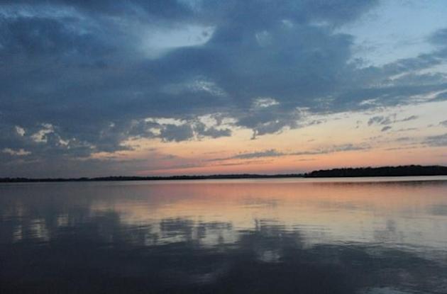
Sitting out by the lake the other day I lamented summer's slow burn, the shorter days & odds of another tough winter. "Are you kidding me?" My friend was aghast. "You don't get it! If it stayed like THIS yearround Minnesota would essentially vanish. We'd become L.A. with lakes, Chicago with walleye. Everything would cost twice as much. Winters keep everything tolerable." He had a point. Our "robust" winters (often over-exaggerated for effect) are a safety net; a meteorological insurance policy.
Some dread winter, but I'm amazed by how many locals love the extremes, the "Theater of the Seasons". That theater has put on quite a show this summer: record dew points & humidity levels, frequent severe storms & (mercifully) far fewer tornadoes than 2010.
Now comes word that Arctic sea ice reached its lowest level on record in July; MIT researchers fear that ice may be thinning 4 times faster than earlier predicted. According to NOAA July was the 7th warmest on record, worldwide.
Fresh air returns today, no blobs on Doppler. A stray storm pops up Friday, a much better chance of T-storms Sunday. Let the record show: Saturday now looks like the nicer/sunnier day of the weekend.
Climate Stories...
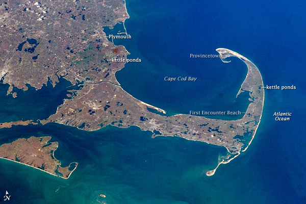
Global Warming Deniers: Grasping At Tiny Straws. Capecodtoday.com has the Op-Ed: "I have debated man's impact on Global Warming or Climate Change many times on this site. Every time, the debate has boiled down to these points of view:
- I say that the vast majority, well over 90%, of climate scientists worldwide agree that human activity is driving Global Warming.
- The person I'm debating says that a significant number of climate scientists say man is not driving Global Warming
http://www.politifact.com/truth-o-meter/statements/2011/aug/14/tim-pawlenty/do-scientists-disagree-about-global-warming/
If you're interested in public policy and you don't know of Politifact.com you should check it out. Politifact won the 2009 Pulitzer Prize in National Reporting for fact checking the 2008 presidential campaign. Politifact wrote its overview in response to the following statement by Tim Pawlenty:
"The weight of evidence on Global Warming is that most of it, maybe all of it, is because of natural causes... it's fair to say the science is in dispute"
Here are a few highlights from Politifact's analysis of world scientific opinion:
"The U.N. Intergovernmental Panel on Climate Change (IPCC), a scientific body considered the leading international organization on climate science. "Most of the observed increase in global average temperatures since the mid-20th century is very likely due to the observed increase in anthropogenic greenhouse gas concentrations"

Rising From Meter Reader To CEO, Xcel's Dick Kelly Has Sound Perspective On Environment. Don Shelby has the story at minnpost.com: "In a week, Dick Kelly will leave Minneapolis and find something to do in Colorado. He will retire as the CEO of Xcel Energy. What will he do? "I've had enough of utilities," he told me. "I'd like to try something different." He deserves a break. He has been working in electricity generation most of his life. On the way to becoming the CEO of one of the most respected electric utility companies in the United States, he walked around with a clipboard and read meters in thousands of backyards. Meter-reader to CEO. It has given Dick Kelly perspective. The kind of perspective Kelly possesses is not seen very often in his business. Dick Kelly believes the facts are in on global warming. "I think the science is pretty solid," he said. "Maybe we haven't communicated it well enough. But I think people do believe we need a change in the way we generate and use electricity...."

Climate Science Is A Glamorous Profession. Cartoon courtesy of the Union of Concerned Scientists.
No comments:
Post a Comment