.44" rain predicted for MSP over the next 24 hours (best chance of showers/T-storms late Friday and Friday night).
70-degree dew points possible for a few hours Friday, then turning less humid over the weekend as skies clear.
Longest stretch of 60+ dew points for Des Moines since the early 1930s. Details below.
3.4 magnitude earthquake at Pierre, SD Tuesday (shook the ground for a 40 mile radius).
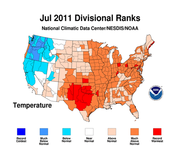
"41 of the lower 48 states had above-normal, much-above-normal, or a record warmest July." - details from NOAA below.
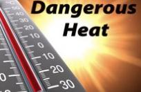
* Tuesday: 40th day/row above 100 in Dallas (all-time record is 42 days/row in 1980). If the mercury goes above 100 every day thru Saturday a new record will be established at DFW.
"...But July was not only scorching hot. July’s Climate Extremes Index, which examines the percentage of the U.S. impacted by a full range of extreme weather conditions, was the highest on record for the month (since 1910). Thirty seven percent of the country contended with extreme weather. The extreme July - for all extreme weather classifications - follows the most extreme spring for precipitation ." - from a post at the Capital Weather Gang. Details below.
Zebra Mussel Alert. Lake Minnetonka is being "overrun" by zebra mussels. More details from the MSRPO below.
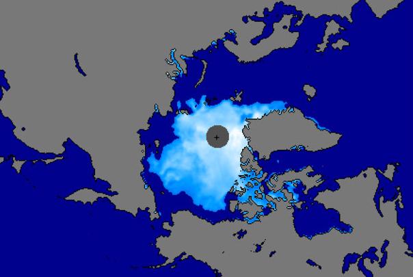
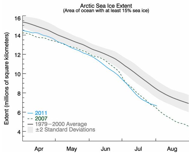
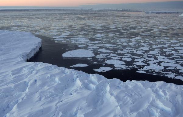
"...One year doesn't say too much in and of itself, but the long-term downward trend and the series of very low years is indicative of a thinner ice cover and warming temperatures," Walt Meier, a National Snow and Ice Data Center scientist said in an email to Bloomberg. The vanishing ice represents a significant piece of evidence for scientists who have been closely watching Arctic ice levels as an indication of the extent of climate change." - from an International Business Times article below.
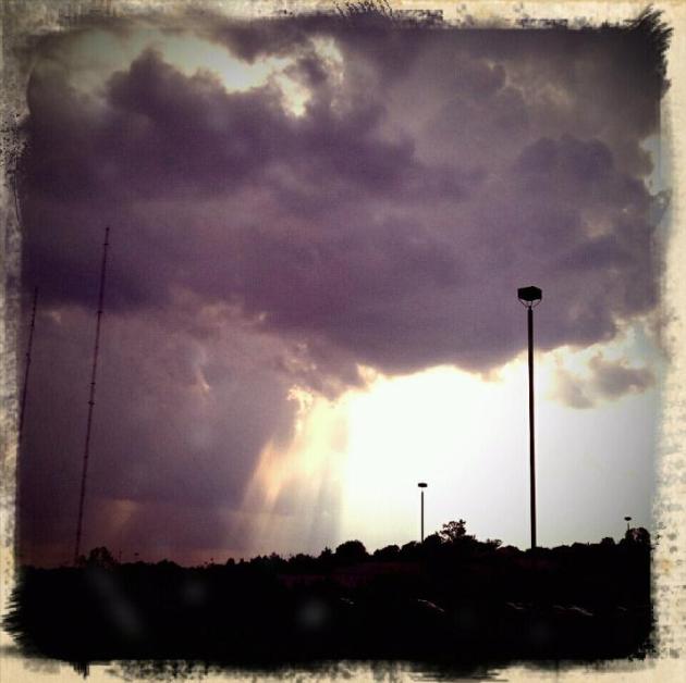
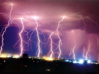
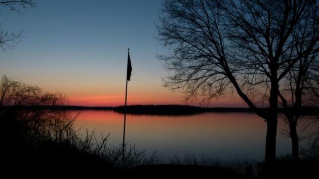
Honorable Mention. Thanks to WeatherNation meteorologist (and KSTP-TV alum) Rob Koch, who took this photo of distant thunderstorms (80 miles away?) from his dock in Scandia, Minnesota.

Wednesday Weather Map. The latest WRF/NAM model (valid 1 pm today) shows dry weather over the Northern Plains and much of the Great Lakes, as well as the western third of America. Heavy showers and storms bubble up over the Central Plains, a few severe storms for Kansas and Oklahoma, more tropical downpours for Florida - a secondary, reinforcing cool front whipping up a few showers from Pittsburgh to Buffalo and Rochester, New York, with instability showers popping up over much of northern New England.
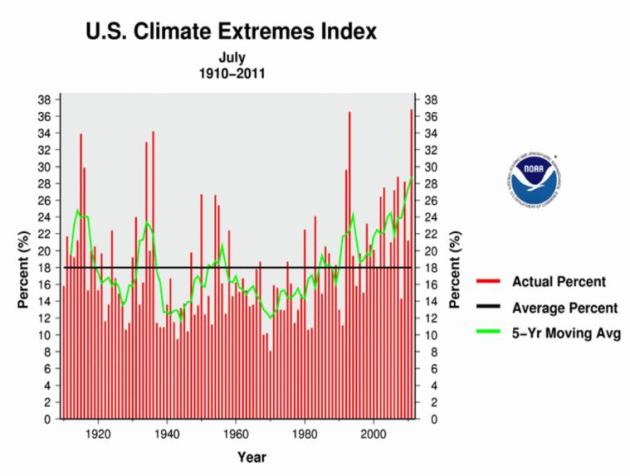
July: Most Extreme And 4th Warmest In U.S. - Oklahoma: Hottest Ever State Temperature. Here's a timely post from Jason Samenow at the Washington Post's Capital Weather Gang: "NOAA released the July “State of the Climate” update for the U.S., and, no surprise, reported blistering heat torched large parts of the country. The average temperature of 77 was the fourth warmest since 1895. Amazingly, Oklahoma’s average July temperature was 88.9 degrees - the warmest to occur in any state during any month on record. But July was not only scorching hot. July’s Climate Extremes Index, which examines the percentage of the U.S. impacted by a full range of extreme weather conditions, was the highest on record for the month (since 1910). Thirty seven percent of the country contended with extreme weather. The extreme July - for all extreme weather classifications - follows the most extreme spring for precipitation . The primary factors which led to such an extreme July were: extreme warm minimum temperatures, extreme wetness in the northern plains and western Great Lakes, extreme warm high temperatures, and extreme drought in the south central U.S. through Gulf Coast." (graphic above courtesy of NOAA and Capital Weather Gang).
4th Warmest July On Record, Nationwide. NOAA has more details:
- Persistent, scorching heat in the central and eastern regions of the United States shattered long-standing daily and monthly temperature records last month, making it the fourth warmest July on record nationally, according to scientists at NOAA’s National Climatic Data Center.
- The heat exacerbated drought conditions, resulting in the largest “exceptional” drought footprint in the 12-year history of the U.S. Drought Monitor. “Exceptional” is the most severe category of drought on the drought monitor scale. Drought conditions at several locations in the South region are not as long lived, but are as dry, or drier, than the historic droughts of the 1930s and 1950s.
- The average U.S. temperature in July was 77.0 degrees F, which is 2.7 degrees F above the long-term (1901-2000) average. Precipitation, averaged across the nation, was 2.46 inches. This was 0.32 inch below the long-term average, with large variability between regions.
- Oklahoma and Texas had their warmest months ever on record, with average temperatures of 88.9 degrees F and 87.1 degrees F, respectively. Oklahoma's statewide average temperature was the warmest monthly statewide average temperature on record for any state during any month.
- 41 of the lower 48 states had above-normal, much-above-normal, or a record warmest July. Only seven of the lower 48 states – all west of the Rockies – experienced a July average temperature near or below the 20th century average.
- Wetter-than-normal conditions occurred along parts of the Gulf Coast, all of the Pacific Coast, and much of the upper Midwest. California tied for its fifth wettest July. Other states that were abnormally wet in July included: Utah (6th wettest), Wyoming (9th), and South Dakota (10th). At the same time, July offered no relief to the parched soils of Texas and Oklahoma where it was the second (tied) and ninth driest July on record, respectively.
- Exceptional drought, as defined by the U.S. Drought Monitor, covers more than 75 percent of Texas (201,436 sq mi). Drought conditions are so harsh in some locations that it would take as much as 20 inches of precipitation in one month to end the drought. In Oklahoma, 100 percent of the state is suffering from moderate-exceptional drought compared to the beginning of the water year (9/28/2010), when drought conditions covered only four percent of the state.
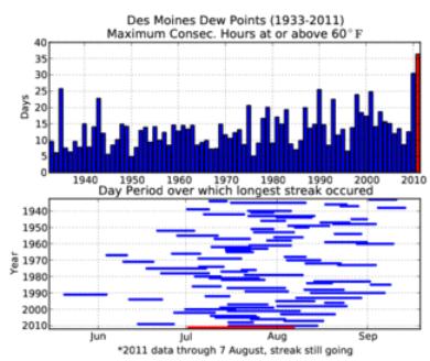
Long Stretch Of Muggy. According to the Iowa Environmental Mesonet the dew point in Des Moines just fell below 60, for the first time since July 3. That's the longest stretch of sticky/steamy weather since the early 1930s.


According to NASA, this year's Perseid meteor shower peaks on the night of Friday, Aug. 12 and into the early morning of Saturday, Aug 13. The Perseids are considered the best meteor shower of the year by many, but with the full moon washing out all but the brightest meteors, rates will probably only be 20-30 per hour at most, weather permitting.
Photo credit above: Sirko Molau, IMO, Archenhold-Sternwarte
More Meteor Details, courtesy of the New York edition of the IB Times:
- This year's Perseid meteor shower peaks on the night of Friday, Aug. 12 and into the early morning of Saturday, Aug 13.
- The Perseids are considered the best meteor shower of the year by many, but with the full moon washing out all but the brightest meteors, rates will probably only be 20-30 per hour at most -- weather permitting.
- Each year in August, the Earth passes through a cloud of the comet's debris. These bits of ice and dust -- most over 1,000 years old -- burn up in the Earth's atmosphere.
- The Perseids can be seen all over the sky, but the best viewing opportunities will be across the northern hemisphere.
- Those with sharp eyes will see that the meteors appear to radiate from the direction of the constellation Perseus.
- This year, unfortunately, when the shower peaks this Friday generating 60 or more meteors per hour, the majestic view will be hampered by the full moon, which will wash out all but the brightest meteors. The meteor will be visible only at 20-30 per hour at most at the peak overnight on August 12 and 13.
- Tuesday night, however, may be the time when the Perseids are most visible to the naked eye.
- Just before the dawn very late Tuesday night or early Wednesday morning, the Perseids could give the best view. If blessed with clear skies, the predawn hour will be the rare window of opportunity of dark, moonless skies. The predawn time on August 10 and 11.
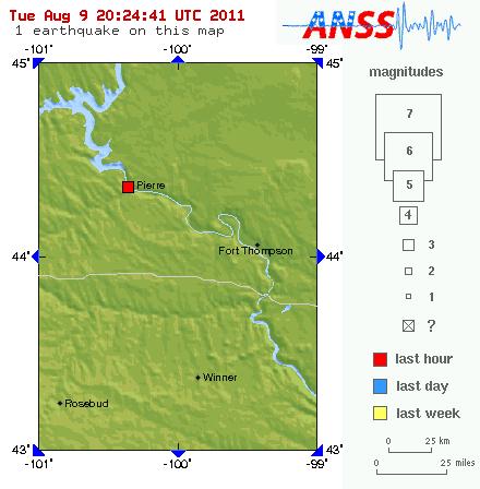
3.4 Magnitude Quake At Pierre, South Dakota. Just when you think it couldn't get any stranger out there, along comes news of a moderate quake in central South Dakota. More details from the USGS.

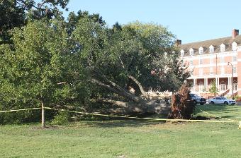
- Strong winds during Monday night's storm have caused severe damage in several Oklahoma communities, including Oklahoma City.
- The roof of a dry cleaner shop near Britton and MacArthur has been lifted by the powerful winds. Reports also say that a semi has been flipped on an overpass that runs over Kilpatrick near MacArthur.
- The Village Police confirmed that several power poles have been knocked down by the wind.
- Reports say a trailer house in Piedmont has been flipped over, roofs are damaged from several houses, and power poles are reported to be down everywhere.
- Oklahoma Red Cross says several other communities have been effected as well, including Waukomis, Lahoma, Meno, Enid, north of Enid, Fairmont, and Covington.
- Damage reported in these communities includes roof damage, windows blown out, home damage, and power lines down.
- So far, one person was injured as the result of this storm. An ADT alarm employee was installing an alarm at a building near Britton and McArthur. He got underneath an awning when the storm blew through. That's when the sign off of the building blew off and landed on the man's leg, trapping him.
- Firefighters had to cut the man out to rescue. He was rushed to the hospital, but we're told he is going to be okay.
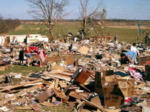
- It’s not possible to economically design wood-frame structures that could resist damage from the highest winds in extreme tornado events, such as EF4 or EF5, but irreparable damage from lesser winds could and should be reduced.
- Tornadoes and hurricanes apply different types of forces to buildings, and what will adequately protect from one type of storm event isn’t identical to the other. Implementing hurricane-region construction practices in a tornado-prone region is a good start, but not an end solution.
- Vertical uplift, one of the special risks from tornadoes, is often not planned for in traditional construction approaches.
- Interior closets and bathrooms can provide some protection at lower wind speeds, but more consideration should be given to construction of “safe rooms” that can save lives in major events.
For reasons that are not clear, 2011 has been one of the most destructive tornado years in history, even in regions of the Midwest and South that experience these storms with regularity." (photo credit: NOAA Magazine).
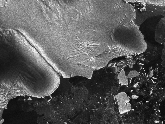
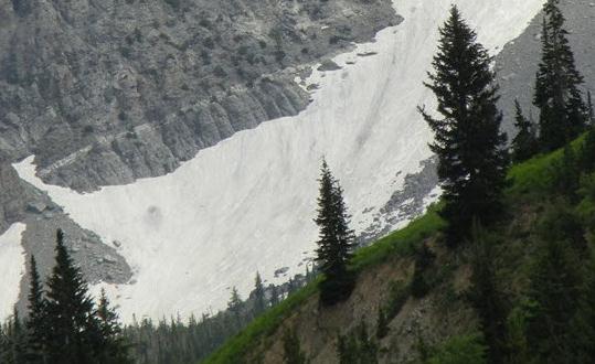
Japan Tsunami Caused Calving Of Antarctic Iceberg The Size Of Manhattan. This is pretty amazing - the record quake that leveled portions of eastern Japan on March 11 carved out a few new icebergs half a world away, over Antarctica. The International Business Times has more details: "For the first time in history, scientists and researchers were able to find a direct connection between tsunamis and the creation of icebergs. Using European Space Agency Envisat data, A NASA scientist and her colleagues were able to provide first observational evidence that a Northern Hemisphere tsunami triggered Antarctic ice-shelf calving more than 13 000km away. The Tohoku earthquake and tsunami that occurred on March 11, 2011 propagated across the Pacific and Southern Oceans reaching Antarctica in less than eighteen hours. On reaching the region, it impinged on the Sulzberger Ice Shelf causing the calving of an iceberg almost the size of Manhattan. As per historical records, this particular piece of ice has previously been stable and never budged for more than 46 years. "In the past we've had calving events where we've looked for the source. It's a reverse scenario - we see a calving and we go looking for a source," Kelly Brunt, a cryosphere specialist at Goddard Space Flight Center, Greenbelt, Md stated. "We knew right away this was one of the biggest events in recent history - we knew there would be enough swell. And this time we had a source." The new findings have been detailed in the Journal of Glaciology, marking the first direct observation of such a connection between tsunamis and icebergs and illustrating the growing evidence of ocean wave impact on Antarctic calving."

"In the old days, the only way to protect your important documents, files, photos and other items in the event of a disaster was to invest in a heavy-duty safe. The only other somewhat reasonable option was to store the majority of those things away from the home, which wasn’t all that practical. The Internet has opened up many new and exciting ways to protect important information in the event of a hurricane, fire, tornado or flood. Below, you will find 75 ways in which you can harness the power of the Internet and modern technology to keep your most important items safe from harm.
Scanning
- Every time you receive a paper statement, scan a copy of it. Periodically upload those scanned copies to a secure online location.
- Scan important documents like birth certificates. In the event that the hard copies are destroyed, you will have quick and easy access to something that will suffice in many situations.
- Upload your driver’s license number, or scan a copy of your most recent driver’s license.
- Go through your old photos. Scan each one of them. If a fire or other disaster doesn’t get them, the ravages of time will. Keeping online copies is the best way to keep them from disappearing forever.
- Scan and keep copies of old letters that only exist on paper. They could go up in smoke if a fire blazed through your home and you would never be able to read them again."
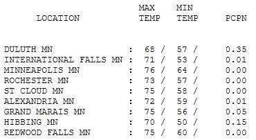
Tuesday: Hints of September. Yes, it did look like late September for a few hours out there yesterday, ragged stratocumulus clouds, a northwest wind gusting over 20 mph, dew points dropping into the 50s. Highs ranged from 68 at Duluth to 75 at St. Cloud, a very comfortable 76 in the Twin Cities.
Paul's Conservation Minnesota Outlook for the Twin Cities and all of Minnesota:
TODAY: Lot's of sun, less wind. Dew point: 54. Winds: W 10-15. High: 77
WEDNESDAY NIGHT: Mostly clear, still comfortable. Slight chance of seeing the Aurora Borealis. Low: 59
THURSDAY: Partly sunny, stray PM shower possible. Dew point: 60. High: 79
FRIDAY: Risk of a T-storm or two. Dew point: 64. Low: 63. High: 77
SATURDAY: Clearing trend, turning less humid. Dew point: 58. Winds: NW 10-15. Low: 62. High: near 80
SUNDAY: Lot's of sun, very nice. Dew point: 56. Winds: SE 8-13. Low: 64. High: 82
MONDAY: Hazy sun, still feels like summer. Low: 65. High: 84
TUESDAY: Sticky, few showers & T-storms likely. Dew point: 65. Low: 67. High: 83

Payback
I have a dear friend who lives in Dallas, Texas. He was a DJ at a tiny 500 watt AM radio station (WHEX). One day in 11th grade study hall I asked Bob "why don't you have your own weather guy on the radio? No more rip and read." He put me on the air, made me change my name (telling me the guys at his stations were "too stupid to remember their own names; they'd NEVER be able to pronounce my real name.") That's how my broadcast career got started. Luck. Chance. Good timing.
Bob likes to taunt me every winter. "Hey, it's 65 in Dallas today. What's it like up in the Twin Cities?" Long pause. I haven't heard much from him this summer, and for good reason. Dallas is on it's 40th day/row above 100. At least we can pile on more clothes when it gets cold.
Lake Minnetonka is being "overrun" by zebra mussels, while scientists marvel at the rate of ice melt in the Arctic. Cargo ships can now sail from Europe to Asia, going NORTH of Russia.
It feels like late September out there this morning, but we mellow into the 80s by the weekend. Plenty of summer left, have no fear! T-storms drift into town by Friday; skies clear Saturday with lukewarm sun spilling into Sunday. Details on my blog.
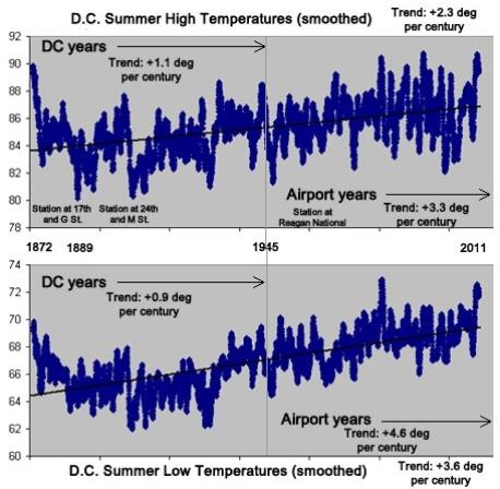
Is There A Global Warming Signal In Washington D.C. Summer Temperatures? Jason Samenow from the Washington Post's Capital Weather Gang poses the question - and examines the trends in the D.C. area: "There is no disputing the D.C. summer climate has warmed signficantly since record-keeping began in the late 1800s. There is an overall warming trend of about 3 degrees F per century - slightly greater at night (+3.6 degrees/century) and lower during the day (+2.3 degrees/century). But what one might dispute is the cause. In my August 1 column on July’s record-breaking heat in Washington, D.C., after describing the onslaught of heat records the last two summers, I wrote: “The two primary suspects for the warming trend are urbanization and the increasing concentration of greenhouse gases in the atmosphere from burning fossil fuels.” Due to space constraints, a wonky, but important sentence was cut by editors: “Unpacking the relative contribution of urbanization and greenhouse gases to the warming is difficult locally, compounded by the fact the location of D.C.’s observing station changed from 24th and M St. for most years prior to 1945 to Reagan National airport thereafter.”
Graphic credit above (courtesy of Capital Weather Gang): "Unadjusted D.C. summer temperatures (average highs and lows - smoothed using a summer long moving average) since 1872. From June 1872 through June 1945, observations were taken either at 17th and G NW or 24th and M St. NW at an elevation of 100 feet. Since July 1945, observations have been taken at Reagan National Airport, at an elevation of about 60 feet. (Data courtesy National Weather Service and Ian Livingston)"
No comments:
Post a Comment