83 F. high in the Twin Cities Thursday.
Isolated shower possible today (better chance of showers, thunder closer to Duluth).
48-53 F. dew point predicted for Saturday, the most comfortable day in sight, the sunnier day of the weekend.
1985: last time a hurricane came within 75 miles of New York City.
Paul's Conservation Minnesota Outlook for the Twin Cities and all of Minnesota:
TODAY: Humid with intervals of sun, a stray T-shower possible. Dew point: 62 Winds: SW 10-20. High: 83
FRIDAY NIGHT: Clearing, turning breezy and less humid. Low: 60
SATURDAY: Sunny, less humd. Dew point: 49 Winds: NE 10-15. High: 79
SUNDAY: Less sun, isolated shower possible. Dew point: 53 Winds: SE 3-8. Low: 58. High: 78
MONDAY: Partly sunny, showers up north? Low: 62. High: 81
TUESDAY: Intervals of sun, not bad at all. Low: 63. High: 78
WEDNESDAY: Hazy sun, PM showers western MN. Low: 64. High: 81
THURSDAY: Sticky, few T-storms. Dew point: 63. Low: 65. High: 83
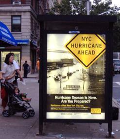
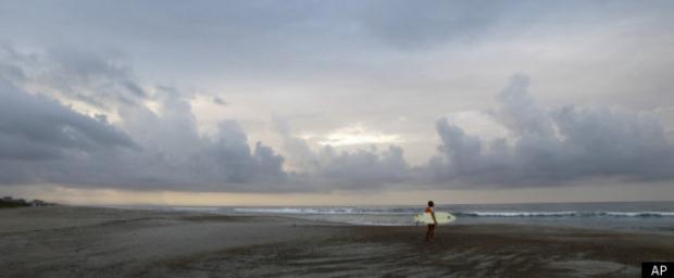
The Big (Windblown) Apple? Hurricane Irene could become the first hurricane to pass within 75 miles of New York City since Hurricane Gloria in 1985. There have been only 5 other hurricanes to fit this category since records began in 1851. A look at past New York City hurricanes in an article below.
7 years since a major hurricane (Category 3 or stronger) hit the east coast of the USA. The last Category 3 storm: Jeanne, which hit Florida's east coast in 2004.
New York City Hurricane Information:
- Forecasters predict Irene to make landfall early Sunday morning in the eastern part of Queens, New York City, as a Category 1 storm.
- No watches or warnings.
- New York City Mayor Michael Bloomberg ordered the evacuation of nursing homes and hospitals located in low-lying coastal areas, such as Battery Park City in lower Manhattan, Coney Island in Brooklyn and Far Rockaway in Queens, beginning Friday.
- The governor declared a state of emergency and the state's Office of Emergency Management has increased staffing in its underground bunker.
- Last hurricane to hit was Hurricane Gloria in 1985 on Long Island as a Category 2 storm with winds gusts of up to 100 mph. Since then, numerous remnants of hurricanes that have struck the state.
- Officials expect to shut down the city's entire transit system at some point Saturday afternoon.
* more state by state hurricane information is
here, courtesy of the Associated Press.
Hopeful News For New York City. The 00z NAM model run suggests a track EAST of NYC early Sunday, with the most extreme storm surge for eastern Long Island, coastal Connecticut, Rhode Island and Cape Cod.
"...
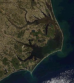
North Carolina's Outer Banks, which look the likeliest to get a serious hit from Irene, have a long history of hurricanes, and building codes and emergency plans reflect that. Structures in the region are designed to withstand up to 110 mph sustained winds and gusts of up to 130 mph for three minutes. Evacuation routes are meticulously planned, down to the order in which counties hit the road." - from a Huffington Post article on Hurricane Irene preparation below.
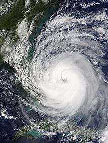
Getting Stronger. Central pressure is falling, the "eye-wall" is contracting, Irene is passing over 86 degree ocean water, with minimal wind shear over the next 18-24 hours - meaning ripe conditions for Hurricane Irene to transform into a Category 4 storm as early as today.
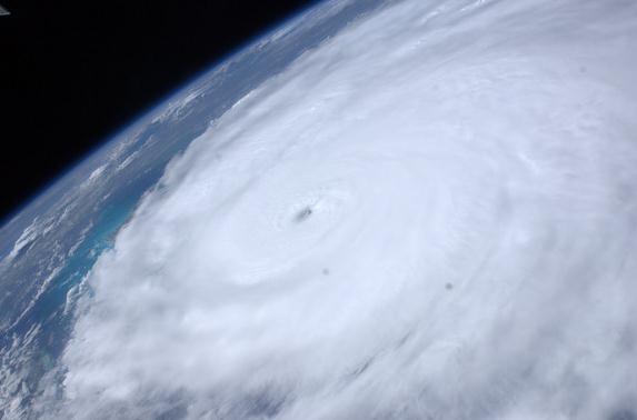
Hurricane Irene Looks "Terrifying" From Space, Astronaut Says. Here's a post from
space.com: "Hurricane Irene is bearing down on the U.S. East Coast and has turned into a frightening storm, according to an astronaut on the International Space Station. NASA astronaut Mike Fossum said that Hurricane Irene, like all hurricanes, looks "terrifying from above," and its evolution into a major storm this week has been unmistakable from orbit. "We saw a big change in the structure of the storm over the several days that we've watched her, especially yesterday," Fossum told SPACE.com today (Aug. 25) during a
video interview from space.
Photo credit: "Astronaut Ron Garan tweeted this picture of Hurricane Irene from the International Space Station on August 24, 2011: "Ominous view #FromSpace of Hurricae #Irene east of the Bahamas @ 3:14pm EST today. East FL coast is calm b4 storm." Thanks to NASA, via Ron Garan/@Astro_Ron
 Bad News For North Carolina's Outer Banks
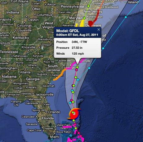
. The GFDL
model is showing 125 mph (Category 3) sustained winds for the Outer Banks of North Carolina by 8 am Saturday morning. That could mean a 10 foot storm surge for portions of the Outer Banks - capable of cutting of Highway 12, the main north-south artery on the barrier island. Map courtesy of Ham Weather, a division of WeatherNation.
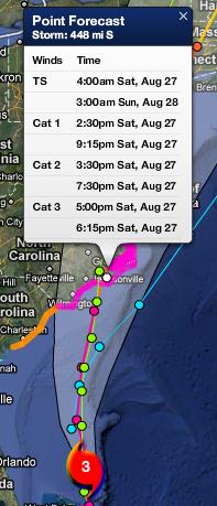 Timing
. Tropical storm-force winds reach the Outer Banks roughly 4 am Saturday, Category 1 winds (74 mph+) by 2:30 pm Saturday afternoon, Category 2 winds (96 mph+) by 3:30 pm, extreme Category 3 winds (111 mph+) by 5 pm Saturday. Map courtesy of Ham Weather, a division of WeatherNation.
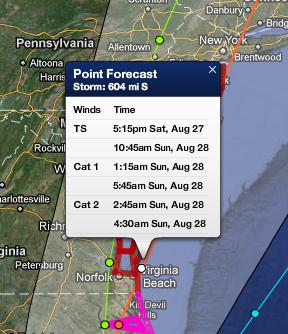 Category 2 Winds Predicted For Virginia Beach.
 Hurricane force winds are forecast to reach Virginia Beach, Newport News and the Norfolk area by 1:15 am Sunday, Category 2 winds by 2:45 am Sunday morning. The Navy has ordered all 68 ships out to sea - to avoid damage to Navy vessels (and piers onshore).
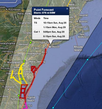 Category 1 Winds For New York City?
 Models are hinting at tropical storm force (40 mph+) winds reaching NYC by 10:15 am Saturday, Category 1 winds (74 mph+) reaching the Big Apple by 5 pm Sunday afternoon, lingering into the evening hours. One plus:
Hurricane Irene is forecast to accelerate to the north-northeast, meaning only a few hours of hurricane force winds for New York City and Long Island.
Deja Vu All Over Again? Check out the track of Hurricane Gloria, in 1985. Very similar to the projected track of Hurricane Irene. Here's more on Gloria, courtesy of those amazing, all-knowing weather nerds over at
Wikipedia: "
Hurricane Gloria was a powerful Cape Verde-typehurricane that formed during the 1985 Atlantic hurricane season and prowled the Atlantic Ocean from September 16 to September 28. Gloria reached Category 4 status on the Saffir-Simpson Hurricane Scale near the Bahamas, but weakened significantly by the time it made landfall on North Carolina's Outer Banks. Gloria closely followed the Mid-Atlantic coastline and made a second landfall on Long Island, and, after crossing the Long Island Sound, it made a third landfall in Connecticut. Overall, the storm caused extensive damage along the East Coast of the United States, amounting to $900 million ($1.84 billion in today's terms), and was responsible for eight fatalities. The storm was the first significant system to strike the northeastern United States since Hurricane Agnes in 1972 and the first major storm to affect New York and Long Island directly since Hurricane Donna in 1960. It was the last storm to hit the northeast until Hurricane Bob during the 1991 Atlantic hurricane season."
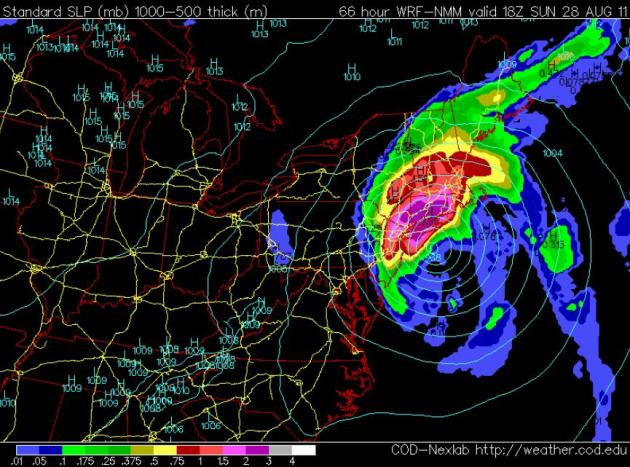
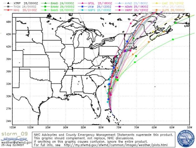
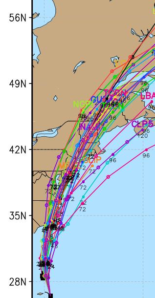
Latest Track Projection. The "cone of uncertainty" is shrinking, the models coming into alignment and better agreement beyond 48 hours. There's little doubt that the Outer Banks will get hit (directly) by late Saturday and Saturday night. After that the margin of error increases. Will Irene hug the coast and hit New York City (directly) or Long Island? The precise track will make a HUGE difference, since the most extreme storm surge will come JUST EAST of where Irene comes ashore.
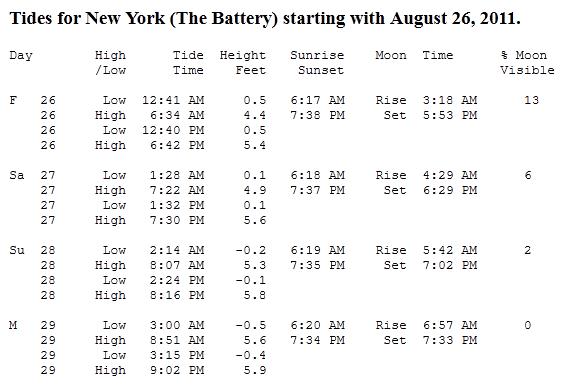
Unhappy Coincidence. High tide Sunday evening is 8:16 PM at The Battery, in Lower Manhattan. That's approximately what time hurricane force winds are predicted to arrive in New York City. The combination of high astronomical tide plus the storm surge whipped up by Hurricane Irene may result in tides as much as 3-8 feet above normal, with a potential for serious flooding across Lower Manhattan and Brooklyn. Click
here to see the tide info for New York City.
New York City Hurricane History. Here's a good recap of previous hurricanes in the Big Apple, courtesy of
elementlist.com: "
We just heard the CNN morning weatherman say that New York City has not been hit by a major hurricane since "maybe" 1410. If he had done a little research, he'd know that the New York City region was directly hit by a hurricane in 1821 and has been hit by four additional hurricanes at varying degrees of strength since then, most recently in 2004. Here's quick summary of NYC's history of hurricane activity since 1821 that took only one quick Google search to find:
1821: The only hurricane in modern times known to pass directly over parts of New York City pushed the tide up 13 feet in one hour and inundated wharves, causing the East River and the Hudson River to merge across lower Manhattan as far north as Canal Street. Deaths were limited since few lived there at the time."
* photo above courtesy of
lostmanproject.com.
Converging Model Solutions. Dozens of models, and a significant percentage of those weather models bring Irene across far eastern Virginia, Maryland and Delaware into New Jersey - very close to New York City. A worst-case scenario for NYC? A hurricane track 10-20 mile west of Manhattan, placing the island on the eastern side of the track, vulnerable to the worst of the storm surge. High tide Sunday evening is 8:16 pm, coinciding with the approximate time when hurricane force winds will hit The Big Apple. Latest discussion from
NHC:
SOME STRENGTHENING IS INDICATED DURING THE NEXT 12 TO 24 HOURS.
A SLOW WEAKENING SHOULD BEGIN THEREAFTER...BUT IRENE IS EXPECTED
TO APPROACH THE COAST OF NORTH CAROLINA A POWERFUL HURRICANE. IN
FACT...THE HIGH RESOLUTION ECMWF SHOWS A VERY INTENSE CYCLONE
APPROACHING THE NORTH CAROLINA COAST.

SATELLITE AND RECONNAISSANCE FIXES INDICATE THAT IRENE IS MOVING
TOWARD THE NORTH OR 350 DEGREES AT 12 KNOTS. THE HURRICANE IS
ALREADY ON THE WEST SIDE OF THE SUBTROPICAL RIDGE AND IS READY TO
INTERACT WITH SOUTH-SOUTHWESTERLY FLOW AHEAD OF THE THE APPROACHING
MID-LATITUDE TROUGH. IRENE HAS NOWHERE TO GO BUT NORTHWARD WITH A
GRADUAL TURN TO THE NORTH-NORTHEAST AFTER THE CENTER CROSSES OR
PASSES NEAR THE NORTH CAROLINA COAST. THE TRACK GUIDANCE HAS BEEN
VERY CONSISTENT AND CONTINUES TO BE TIGHTLY CLUSTERED...GIVING NO
REASON TO MAKE A SIGNIFICANT CHANGE TO THE OFFICIAL FORECAST.
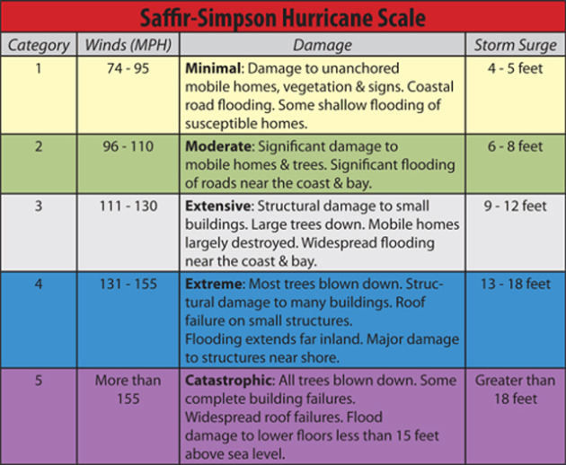
Saffir-Simpson Scale. Much like the Fujita scale is used to rate tornadoes from 0 to 5, the Saffir Simpson scale is used to qualify hurricanes. "Irene" may strengthen into a Category 4 storm today before (probably) weakening into a Category 3 storm as it plows into the Outer Banks of North Carolina - possibly a Category 1-2 storm as it brushes the east coast from Delaware to Long Island (Sunday). Hurricane Irene is capable of a 10 foot storm surge over the Outer Banks of North Carolina - a 6-10 foot surge possible as far north as coastal New England. The worst storm surge conditions will take place east/right of where Irene comes ashore.
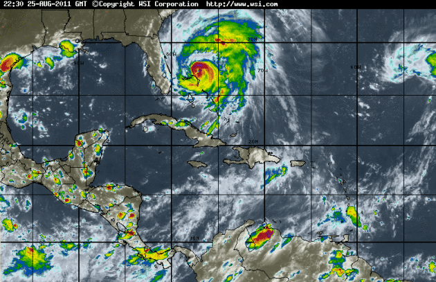
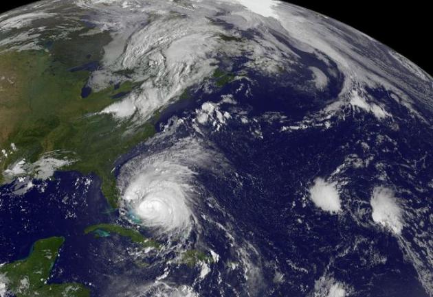
Hurricane Irene: One Third The Size Of The East Coast Of The USA. Irene is larger than Katrina was in 2005. If you were to drive from Indianapolis to Kansas City - that's the size of "Irene". Here's an update on Hurricane Irene from
NASA: "
Hurricane Irene is a major hurricane, and NASA satellite data shows its diameter is now about one-third the length of the U.S. Atlantic coastline. Meanwhile, far in the eastern Atlantic Ocean a tenth tropical depression formed. One satellite image captured both storms and shows the tremendous difference in their size. NOAA's GOES-13 satellite saw Hurricane Irene moving through the Bahamas on August 25, 2011 at 10:02 a.m. EDT and far to the east off the African coast was newly born Tropical Depression 10. The GOES-13 image shows Irene to be almost one third of the size of the U.S. east coast. The distance from Augusta, Maine to Miami, Florida is 1662.55 miles. Hurricane Irene's tropical storm-force winds extend 255 miles from the center making Irene 510 miles in diameter, almost one-third the size of the U.S. Hurricane-force winds extend 70 miles from the center, or 140 miles in diameter. GOES-13 images and animations are created at NASA's GOES Project at the NASA Goddard Space Flight Center, Greenbelt, Md."
Hurricane Irene: East Coast Prepares For Storm. Here's an update from
The Huffington Post: "
BUXTON, N.C. -- Thousands were fleeing an exposed strip of coastal villages and beaches off the North Carolina coast and dozens of Navy ships were ordered to leave their port to the north Thursday as Irene approached, threatening to become the first major hurricane to hit the East Coast in seven years. An evacuation order took effect for an estimated 150,000 tourists in coastal Dare County hours after forecasters issued a hurricane watch for much of the state's coast. Meanwhile, emergency officials all the way to New England were scrambling to get ready. Irene could hit North Carolina's Outer Banks on Saturday afternoon with winds around 115 mph (185 kph). It's predicted to chug up the East Coast, dumping rain from Virginia to New York City before a much-weakened form reaches land in Connecticut. Dare County officials were considering making thousands of year-round residents leave, too. "It wouldn't behoove anyone to stay in these circumstances," Dare County emergency management spokeswoman Sharon Sullivan said. "Businesses are boarding up. Nobody can guarantee their safety." The Navy ordered the Second Fleet in southeastern Virginia, including at Norfolk Naval Station, to leave so ships would be safe from the approaching hurricane. Thursday's order applied to 64 ships in the area, some of which were already at sea."
Three Steps To Disaster Preparation. Here's a timely article from
CBC in Canada: "
Hurricanes and tropical storms, while more common in the Caribbean and the southeastern United States, do pose a threat to Canadians living off the coast of the Atlantic Ocean. Unlike tornadoes, which are spontaneous and unpredictable, hurricanes can be tracked effectively by meteorologists who can give early warning to people living in at-risk areas. The best way to keep safe during a hurricane or tropical storm is to make sure you understand the risk attached to these disasters well before the May to November hurricane season. Environment Canada has identified three aspects of hurricane safety, which broadly break down this way:
1. Infrastructure and construction
Before a hurricane watch or warning has been issued, it's a good idea to prepare your home, in case the warning comes with shorter notice than usual. This is especially important for seaside houses and cottages. Long-term steps could include:
- Building artificial reefs to keep high waves from hitting shore.
- Building levees in coastal areas to protect from high water surges.
- Strengthening windows, doors, roofs and outlying buildings against high winds and water swells.
- Having adequate insurance in case of extensive damage."
Hurricane Tips. Here is more solid information and tips from
FEMA:
Step 1: Build A Kit / "To-Go Bag"
Get an Emergency Supply Kit, which includes items like non-perishable food, water, a battery-powered or hand-crank radio, extra flashlights and batteries. You may want to prepare a portable kit and keep it in your car in case you are told to evacuate. Step 2: Make a Plan
Prepare your family
Make a Family Emergency Plan. Your family may not be together when disaster strikes, so it is important to know how you will contact one another, how you will get back together and what you will do in case of an emergency. You should also consider:
Hurricane Irene Prediction. Here is the latest from Planalytics, a weather research firm based in the Philadelphia area:
"Currently, Hurricane Irene is expected to severely impact the Outer Banks on Saturday, then take a northward track. On Sunday and Monday, Irene will bring high wind and very heavy rain to the Mid-Atlantic and Northeast, with hurricane force gusts possible in the Philadelphia and NYC metro areas. Massive beach erosion is expected along the coast. Widespread areas of 5+ inches of rain, falling on already saturated ground, will cause significant flooding of rivers and streams from Washington, DC through New England.
* Irene has the potential to be the most significant system in the Northeast since 1938.
* Rain and flooding will cause more damage than wind. Widespread power outages are likely.
* Clean-up will continue through the Labor Day weekend, negatively affecting retail traffic, but driving increased sales at Home Centers."
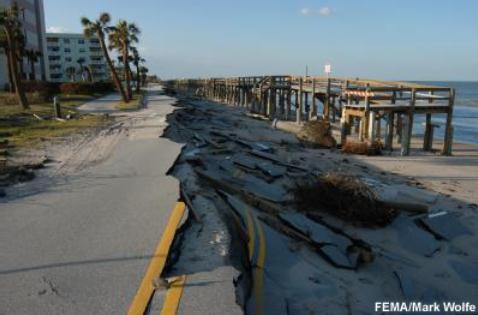
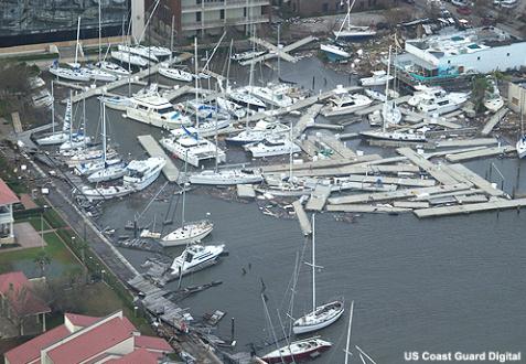
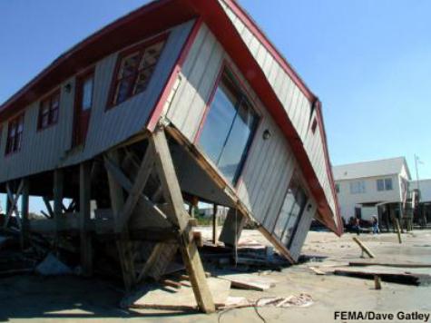
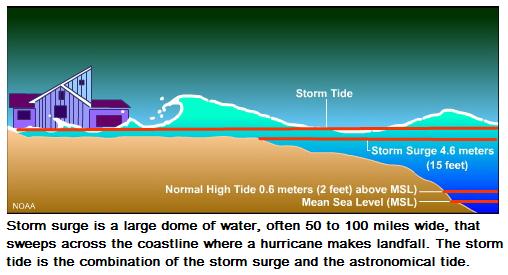
Biggest Threat: "Storm Surge". It seems like wind speeds get a lot of attention when covering hurricanes (as they should), but the biggest killer is the storm surge. The combination of very low atmospheric pressure coupled with sustained winds creates a "dome" of water, which is pushed ashore ahead of a hurricane's eye. Tides can rise 3-5-10 feet, in a matter of minutes, cutting off escape routes and inundating the first 2 floors of coastal dwellings. This is why authorities are urging coastal residents of North Carolina to evacuate inland. Similar evacuation orders may go out for coastal Delaware, Maryland, New Jersey, Long Island, Connecticut and Massachusetts in the next few days.
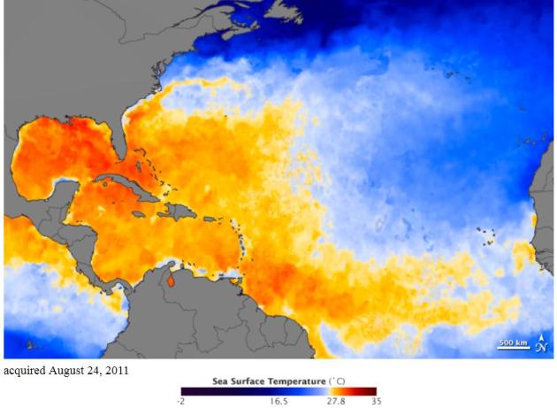
Hurricane Fuel: Warm Ocean Water. The warmer the ocean water (all other things being equal) the greater the potential for hurricane intensification. Here's a post from
NASA's Earth Observatory: "
As Hurricane Irene rumbles through the Atlantic Ocean, it needs fuel to sustain itself. Warm water is the main fuel, and there is plenty of it right now, as there usually is this time of year. The map above shows sea surface temperatures (SST) in the Atlantic Ocean, Gulf of Mexico, and the Caribbean Sea on August 23, 2011. The measurements come from the Advanced Microwave Scanning Radiometer (AMSR-E) on NASA’s Aqua satellite and the Moderate Resolution Imaging Spectroradiometer (MODIS) instruments on both the Terra and Aqua satellites. The satellites measure the temperature of the top millimeter of the ocean. Waters typically need to be above 27.8 degrees Celsius (82 Fahrenheit) to properly fuel tropical storms with warm, moist air. Red, orange, and yellow colors depict waters above the 27.8 degree mark. The warmer the water, the more intense the storm can grow, if upper level wind patterns cooperate. In the map above, such waters dominate the Gulf of Mexico and tropical Atlantic in late August 2011. They also run up the southeastern coast of the United States, following the Gulf Stream to Cape Hatteras before giving way to slightly cooler waters (shades of blue) in the Middle and North Atlantic."
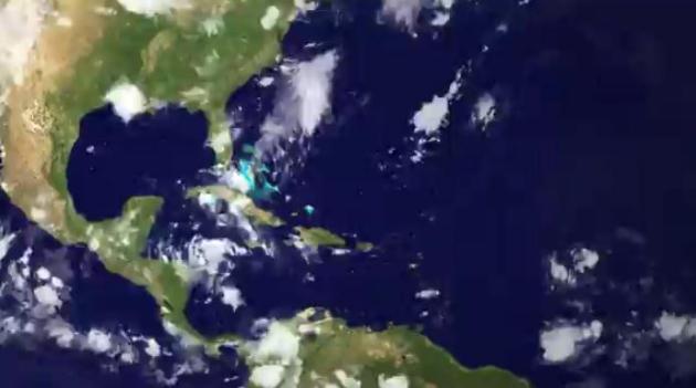
Evolution Of Hurricane Irene. Here's a good time-lapse from
NOAA: "
Hurricane Irene's evolution from tropical wave to Category 1 storm is shown here in time-lapse imagery from the GOES-East satellite starting on August 19th and ending at 1245z on August 23, 2011. On of the last frame, the storm is a Category 2 with sustained winds of 100 mph, centered at latitude 20N, longitude 70 W."
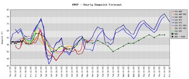 Dew Point Prediction
. Dew points reach the low 60s today, and then drop into the upper 40s and low 50s Saturday, the most comfortable day in sight. Dew point temperatures are forecast to slowly rise next week, reaching (uncomfortable) upper 60s and low 70s in the twin Cities by next Thursday and Friday.
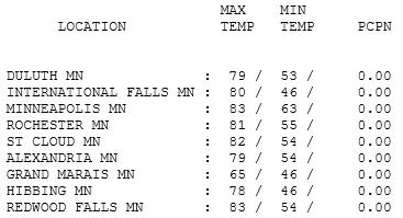
Amazing. Another day in paradise - a perfect Day 1 at the Minnesota State Fair. Highs ranged from 78 at Hibbing (after waking up to 46) to 82 at St. Cloud, 83 in the Twin Cities with dew points close to 50. It seemed a bit surreal that, while we were enjoying some of the best weather of the year, hundreds of thousands of Americans living on the east coast are on the verge of evacuating inland, trying to escape the storm surge generated by Irene.

"Storm Surge"
This is why you think twice about a cruise (or Florida vacation) in late August or September, prime time for hurricanes. "Irene" is larger than Katrina, roughly the size of the distance between Kansas City & Indianapolis.
Recent models have nudged the track farther west, pushing Irene right up the east coast, enabling it to tap warm Gulf Stream water - maintaining hurricane strength as far north as New York City & Long Island. Wind gets a lot of attention in the media, but the greatest killer is the "storm surge". The combination of low pressure & sustained winds can create a "dome" of water, most severe just north/east of landfall. Tides can rise 5, 10, even 15 feet in minutes, cutting off escape routes. Storm surge caused most of the nearly 1,500 deaths from Katrina in 2005.
If Irene tracks just west of New York City a 5-10 foot surge of water may engulf New York Harbor, capable of severe flooding, especially over Lower Manhattan & Brooklyn. We'll see, but I fear Irene may become America's 10th billion dollar disaster in 2011.
A stray T-shower today gives way to bright sun & low humidity Saturday; Sunday looks dry and pleasant too.
No complaints about our weather anytime soon.
On Climate Change, Romney Is Pretty Consistent. Here's a story from
Reuters: "
What Mitt Romney is saying today about climate change is pretty much what he’s been saying all along. First, here is what he said yesterday: Asked about global warming at a town hall meeting in Lebanon, New Hampshire, Romney said he believed the world is getting hotter and humans contribute in some way to the change — but could not judge to what extent. ”Do I think the world’s getting hotter? Yeah, I don’t know that but I think that it is,” he said. “I don’t know if it’s mostly caused by humans.” “What I’m not willing to do is spend trillions of dollars on something I don’t know the answer to.” In June, a day after launching his second bid for the White House, Romney caused a stir by saying he thought humans had contributed to climate change to some extent. At that time he made a call for a reduction of “emissions of pollutants and greenhouse gases that might be significant contributors” to climate change — a suggestion that was not made on Wednesday. A Romney aide said the candidate has not altered his position on climate change." (photo courtesy of dailycaller.com).
Fox News: "Facts Are Certainly" On The Side Of Global Warming, But "It Doesn't Matter." Here's a story from
thinkprogress.org: "
On Fox & Friends Sunday, anchor Clayton Morris admitted that Fox News factcheckers have confirmed that man-made global warming is “certainly” real, but argued that it “doesn’t matter” because climate denial is popular among Fox News-watching conservatives. Morris contrasted Jon Huntsman’s defense of the National Academy of Sciences with Rick Perry’s claims that scientists have “manipulated data” to concoct manmade global warming:
MORRIS: If you dive into the weeds a little bit on this global warming thing, you see that it seems that facts are certainly on Huntsman’s side on all of this and fact checkers have come out, we’re actually having our own brain room look look at this right now that any of Perry’s comments don’t seem to hold a lot of water. It doesn’t matter. What’s resonating right now in South Carolina is helping Governor Perry tremendously and he fired back at Huntsman on global warming and gaining traction, facts or not."
How To Talk To A Climate Skeptic. Here's an article from the U.K.
Guardian: "
Katharine Hayhoe is an associate professor of atmospheric sciences at Texas Tech University in Lubbock, Texas, where temperatures during this summer of record-breaking heat have surpassed 100 degrees on 43 days. While Hayhoe would certainly not argue that this scorching heat is unequivocal evidence of global warming, she is sure of one thing: it's a sign of things to come. Hayhoe is well known not only for her scientific work on the regional impacts of global warming in the U.S., but also for her efforts to reach out to conservative communities — particularly evangelical Christians — to speak with them about the realities of climate change. In an interview with Yale Environment 360, she said she has found much common ground with people by patiently answering their questions, stressing the impact that global warming will likely have on the individuals and places that people love, and discussing actions to blunt climate change that nearly all sides can agree on. "Who doesn't want renewable sources of energy?" Hayhoe told Yale e360 senior editor Fen Montaigne. "Who doesn't want cleaner air and a thriving economy? Who doesn't agree that we should be conservative with what we have? I think this is the way to move forward on this issue."


No comments:
Post a Comment