TUESDAY: Lot's of sunshine, lukewarm. High: 73
TUESDAY NIGHT: Mostly clear and quiet. Low: 53.
WEDNESDAY: Sunshine continues. Comfy temps and low humidity. High: 77
THURSDAY: More blue sky, very pleasant. Low: 58. High: 79
FRIDAY: Another beauty. Low: 59. High 81
SATURDAY: Quiet. More sun with only a few passing clouds. Low: 61. High:80
SUNDAY: Stray PM Shower? Mostly dry. Low: 60. High: 79
MONDAY: Isolated shower or storm early. Clearing through the day. Low: 62. High: 73

It's a bitter sweet day for many parents as most kids head back to school for the first time in nearly 3 months. Happy emotions because kids will get back to a normal routine and 'hopefully' stay out of your hair and out of trouble. This also means that they are another year older and another year closer to spreading their own winds. Just a reminder to folks driving to work and school, now to watch out for kids walking, biking or standing at the bus stop. A lower sun angle through early September means that visibility will be obstructed due to bright sun in your eyes, which will be especially true this week. Other than that, it'll be a picture perfect rest of the week with low humidity and ample sunshine. Not sure it could get much better for the first full week of September. A large bubble of high pressure will settle in for the next few days as it gets blocked by the remnants of Tropical Storm Lee, which continues to pump out tropical moisture through the eastern third of the nation. The remnants of Lee will sit nearly stationary over the Ohio River Valley through Friday, meaning more sunshine for us. No worries from the weather office, enjoy - Todd Nelson

Cold Morning in NE Minnesota
These were the low temperatures reported in the northeastern part of Minnesota on Monday morning. Those spending the night at the cabin Sunday night probably found themselves reaching for the extra blanket as temperatures dipped into the 30s and in some cases into the 20s like Embarrass, MN where the temps dropped to 26F - BRRR!

National Weather Headlines
The tropics are still a big as we slide through the first part of September as we are in peak season. The remnants of Tropical Storm Lee continue to dump copious amount of moisture of the eastern third of the nation and we're still watching Katia in the Atlantic. The Desert Southwest is still baking under triple digit heat and there are several wildfires in Texas and Oklahoma, which have consumed dozens of homes and in some cases have been deadly.

National Satellite and Radar
The national satellite and radar shows some very quiet weather west of the Mississippi River Valley other than the Desert Southwest, where monsoonal showers and thunderstorms are still present. The big story is the heavy rain and scattered storms from the remnants of Tropical Storm Lee. You can also see hurricane Katia out in the Atlantic, which as of midday Tuesday was still a category 2 storm.

Rainfall Amounts From Lee
This slow moving, drought busting, rain is really coming down in sheets and has been through since the Labor Day Weekend. Take a look at some of the rainfall amounts, which are always being updated.

Dry Air Plunges South
Look at all that dry air via the water vapor satellite, plunging south on the back side of Lee. Keep in mind that this very dry and breezy weather, which is not helping an already very fire prone area across the Deep South.

Active Texas Wildfires
The wildfires across Texas have combined to become one of the worst fire seasons in the states history. Here is some information from channel6newsonline.com - you can read the full story HERE:
"Since the beginning of wildfire season, local and state firefighters have responded to more than 20,900 fires that have destroyed more than 1,000 homes and burned more than 3.6 million acres (1.4 million hectares). Governor Rick Perry issued a disaster proclamation on December 21, 2010 and has reissued it nine times."

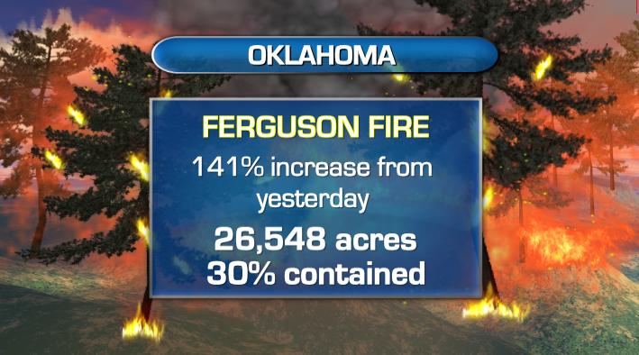
More Fires in Oklahoma
Oklahoma has been battling fires of their own. The Ferguson Fire is a big fire that quickly grew over the Labor Day Weekend.
Here's more on the Oklahoma fires from abcnews:
Here's more on the Fergus Fire from inciweb.org:
Smoke Plumes Seen From Space

Hurricane Katia
The Southern Plains really need rain, unfortunately, it doesn't look they'll be getting any in the very near future, but Hurricane Katia continues to churn towards the U.S. - Katia had a very defined "eye" on Monday afternoon: Here's the latest on Katia from the National Hurricane Center

Hurricane Katia Steers Away From The U.S.?
The good news is that Katia appears to be steering away from the U.S. by this weekend, only brushing the New England Coastline with spotty showers and heavy surf.

Thanks for checking in, enjoy the rest of your week
Meteorologist Todd Nelson
No comments:
Post a Comment