FRIDAY: Another beauty. High 81
FRIDAY NIGHT: Mostly clear, quiet and not as cool. Low: 59
SATURDAY: Quiet. More sun with only a few passing clouds. High:80
SUNDAY: Increasing clouds, stray PM Shower? Mostly dry. Low: 61. High: 81
MONDAY: Unsettled. Spotty afternoon thunder possible. Low: 61. High:78
TUESDAY: Breezy and cooler with lingering AM clouds. Low: 58. High:69
WEDNESDAY: Less wind, still cool and more sun. Low: 50. High: 66
THURSDAY: Looking dry and a little warmer. Low: 50. High: 72
Catch 22... Yes, it's nice having sunshine several days in a row, but what happens when you have too many days in a row of sunshine and mild temperatures? You're lawn gets crispy and yellow. Sure, it would be nice to get a little rain, but I don't think too many people are complaining about our current weather, especially knowing what might be lurking around the corner in the not to distant future. The atmosphere is still all blocked up thanks to tropical systems Lee and Katia. The remnants of Lee squeezed out an additional 8" to 12" of rain in spots that had already seen 10" to 20" of rain 2 weeks ago with Irene. Massive flooding, evacuations and even fatalities have been reported with this latest round of tropical moisture in the Northeast. Unfortunately, the rich keep getting richer and the poor are getting poorer. As rain continues in the East, drought and fires continue in the Deep South. Texas and Oklahoma continue to battle large and deadly wildfires, but Tropical Storm Nate in the Gulf of Mexico may wobble into Texas. It's a big if at this point, but Texans are crossing fingers, toes and eyes for anything. Our next best chance of rain slides in Monday as a cool front approaches from Canada - Todd Nelson
Weather Setup
There hasn't been much change in the weather across that nation as of late because of those 2 pesky tropical systems (The remnants of tropical storm) Lee and Hurricane Katia. Everything has been blocked up for several days and it should continue that way for a few more days until Hurricane Katia clears the East Coast and lifts into the Canadian Maritimes. Once that happens, we'll see "ROTSL" (Remnants Of Tropical Storm Lee) finally lift northeast by late weekend. This should also allow for a more active pattern to take shape for the Upper Midwest as the first cool front drops south of the International border by Monday.

ROTSL (Remnants Of Tropical Storm Lee)
The remnants of Tropical Storm Lee have really been a problem over the past several days. The latest numbers coming in from the Northeast are impressive to say the least. An additional 8" to 12" have been reported in spots that picked up anywhere from 15" to 20" with Hurricane Irene 2 weekends ago. Flooding was aggravated as additional heavy rain fell on already saturated ground. Take a look at what a few airports were reporting over a two day period from AM Tuesday into AM Thursday.

100,000 Evacuated Along the Susquehanna
Just when we thought we were done with the ridiculous rainfall, here comes another push of tropical moisture prompting the evacuations of nearly 100,000 along the Susquehanna.
Susquehanna River at Wilkes Barre, PA
This is crazy - look at the river gauge along the Susquehanna River at Wilkes Barre, PA. This gauge below shows nearly a 30 foot rise in almost 36 hours, expected to crest near the record of

The rich get richer in the Northeast with too much rain, while the poor get ever poorer with more hot dry weather spawning nasty wildfires.
Here's a story from Yahoo News on the fires in Texas
The National Weather Service today released a statement that put the heat this summer into some perspective: Read the full story HERE:
Officials with the National Weather Service announced on Thursday that June, July and August in Texas were the hottest summer on record for any U.S. state.
Texas averaged 86.8 degrees Fahrenheit over the three months, National Weather Service meteorologist Victor Murphy told The Associated Press, beating out Oklahoma's 85.2 degree average in 1934.
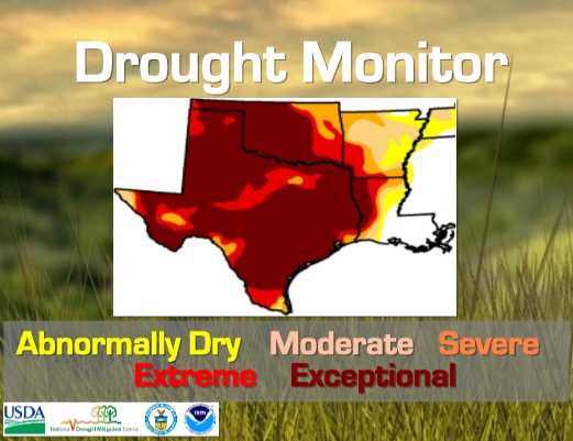
Massive Drought Continues
This is the updated drought monitor, which shows improvement near New Orleans because of Tropical Storm Lee, unfortunately, we didn't get any of that moisture in Texas.
Rain Needed to End Drought
Several months of very dry weather has led to unbelievable rainfall deficits. Take a look at the rainfall amounts that are needed to end the drought across the Deep South

Is There Any Hope?
There might be a little hope. Way down in the southern part of the Gulf of Mexico, Tropical Storm Nate slowly wobbles to the north. Some of the latest forecasts have this storm, maybe getting close to Texas by the weekend.

How Do You Solve A Problem Like Maria?
We're still watching Maria closely as she is taking more of a southerly track, just like Irene did. The forecast track has her staying at tropical storm strength, which is good, but as warm as the ocean water temperatures are, this certainly could jump up to hurricane strength as it near the U.S. This is definitely something to watch into next week.

Weekend Auroras
Storms on the sun since the Labor Day Weekend have been sending charged particles towards Earth and may spark northern lights across the higher latitudes this weekend.
Here's the story from Spaceweather.com
Since Sept. 6th, sunspot 1283 has propelled at least three CMEs in the general direction of Earth. Glancing blows from the incoming clouds will commence sometime on Sept. 9th and continue through Sept. 11th, possibly sparking minor geomagnetic storms.
Saturday's Forecast - MODERATE
Forecast: Auroral activity will be moderate. Weather permitting, moderate displays will be visible overhead from Inuvik, Yellowknife, Rankin, and Igaluit to as far south as Whitehorse, Ft. McMurray, James Bay and visible low on the horizon as far south as Prince Rupert, Calgary, Minot, Bemidji, Stevens Point, Traverse City and Quebec City, Canada.

Sunday Forecast - ACTIVE
Forecast: Auroral activity will be active. Weather permitting, active auroral displays will be visible overhead from Inuvik, Yellowknife, Rankin and Igaluit to Juneau, Edmonton, Winnipeg and Sept-Iles, and visible low on the horizon from Vancouver, Great Falls, Pierre, Madison, Lansing, Ottawa, Portland and St. Johns.

Thanks for checking in, have a good rest of the week!
Meteorologist Todd Nelson
No comments:
Post a Comment