32 F. Friday morning at MSP
International - first 32-reading since May 3 in the Twin Cities. The average ("mean") date of the first 32 at MSP
is October 7, according to the MN State Climatology Office.
70 on Sunday? 1 in 3 chance that the mercury at MSP will hit 70 by mid afternoon Sunday.
+9.2 F. October temperatures in the Twin Cities are running more than 9 degrees warmer than average, to date.
 Mild start to November?
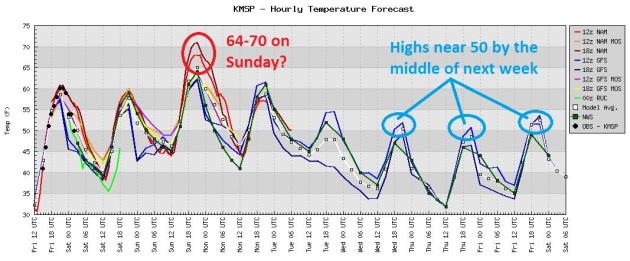
 The GFS is hinting at one, possibly two 60-degree days during the first week of November at MSP.
 Good Timing
. The mercury inflates to near 60 again today, but readings may climb into the mid 60s Sunday, a few models take the mercury up to 70, with enough marginal instability for a few isolated T-showers. Thunder in late October? Rare, but hardly unprecedented.
 Halloween Preview
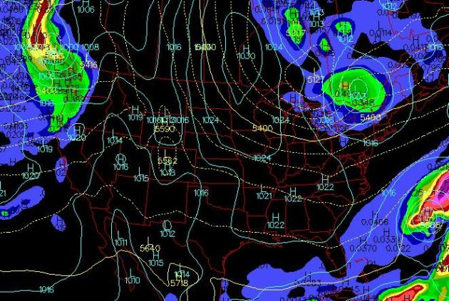
. A Canadian high should result in a mostly clear, cool Halloween from the Twin Cities to Milwaukee, Chicago, St. Louis and Denver. Rain is possible over the Pacific Northwest and parts of northern New England. No major storms are brewing between now and Halloween.
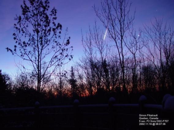
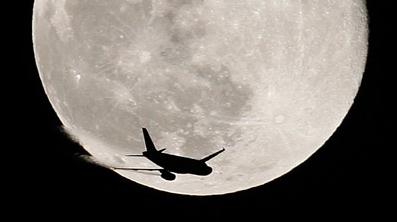
Orionid Meteor Shower. NASA has more details on a weekend meteor shower which should be visible across Minnesota and much of the USA: “
Earth is about to pass through a stream of debris from Halley’s comet, source of the annual Orionid meteor shower. Forecasters expect more than 15 meteors per hour to fly across the sky on Saturday morning, Oct. 22nd, when the shower peaks.”
* Click
here to read more about the Orionid Meteor Shower from spaceweather.com.
 Friday Record Lows
. Data courtesy of NOAA:
THE LOW TEMPERATURE YESTERDAY AT CHANUTE KS WAS 25.  THIS TIED THE
PREVIOUS RECORD SET IN 1989.
A RECORD LOW TEMPERATURE OF 30 DEGREES WAS SET AT TULSA OKLAHOMA
TODAY. THIS TIES THE PREVIOUS RECORD SET IN 1976.
A RECORD LOW TEMPERATURE OF 25 DEGREES WAS SET AT FAYETTEVILLE
ARKANSAS TODAY. THIS BREAKS THE PREVIOUS RECORD OF 26...SET IN 1964.
A RECORD LOW TEMPERATURE OF 19 DEGREES WAS SET AT PIERRE SD TODAY.
THIS BREAKS THE OLD RECORD OF 23 SET IN 1987.
 The Other Shoe Drops
. Here's an excerpt from this week's edition of
WeatherTalk from Mark Seeley: "
After starting October with two weeks of unusual warmth, thermometers recorded below normal temperatures on many days this week, bringing another round of widespread frosts. On Thursday, October 20th some observers reported lows in the 20s F, including: 28 degrees F at Luverne, Tracy, Worthington, Grand Marais, Orr, Detroit Lakes, Fergus Falls, and Grand Rapids; 27 degrees F at Warroad and Hibbing; 26 degrees F at Embarrass; 25 degrees F at Marshall, Wheaton, Ortonville, Thief River Falls, Big Fork, Roseau, Wadena, Moorhead, and Aitkin; 23 degrees F at Staples and Crookston; 22 degrees F at Kelliher; 21 degrees F at Pine River, Mahnomen, and Fosston; 20 degrees F at Park Rapids; 19 degrees F at Hallock, Waskish, Morris, and Bemidji. The 19 degrees F was coldest in the contiguous 48 states on October 20th."
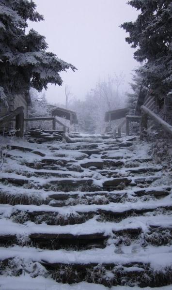
Mt. LeConte, Tennessee Snowfall. Details:
"Snow Thursday morning atop Mt. LeConte, Tennessee. They received about 1". The picture is courtesy of the NWS office at Morristown, Tennessee."
Thailand Counting Cost As Flood Seeps Into Bangkok. Seattlepi.com has the latest on historic floods gripping Thailand and much of southern Asia: "
BANGKOK (AP) — Floodwaters that have devastated Thailand's industry and agriculture seeped into outer Bangkok on Friday as the crowded capital's residents braced for the impact, uncertain if they will soon be hopping over puddles or fording waist-high streams just outside their windows. Thailand's prime minister urged residents of the city of 9 million people to get ready to move their belongings to higher ground. Key gates on flood-control canals in the capital have been opened in a risky move to drain the high waters into the sea, but it's not known how much will overflow onto streets. An Associated Press team saw water entering homes and rising to knee level Friday in a northern district along the capital's main Prapa canal. Damage so far was minor and not affecting Bangkok's main business district. Prime Minister Yingluck Shinawatra said the Prapa canal was a big concern and urged people "not to panic."
Six Years After Hurricane Katrina, Recovery Continues On Mississippi Gulf Coast. WDBJ7.com has the follow-up story: "
Six years have passed since Hurricane Katrina devastated the gulf coast of the United States. Since then, many families have picked up the pieces. Some have moved away. And others are still struggling to rebuild their lives. News7 recently visited Mississippi for the fourth time since 2005 to guage the continuing impact from the costliest hurricane in U.S. history. "I spent two days boarding up all the doors and windows with plywood when I should have been hauling everything north of the tracks," Gulfport resident Jack Bethea told us recently, reflecting on his preparations for Hurricane Katrina. When we first met Bethea in 2005, he was picking through the ruins of his three-bedroom brick house. Two years later he was living in a FEMA trailer. Now, he's across the street in a home his mother owned. "Mother's house could be repaired," Bethea told us, "thanks to a lot of church volunteers."
 Tarpon Springs Hurricane - 90 Year Anniversary.
 The Tampa office of the NWS has an interesting recap of the major hurricane that struck 90 years ago - and what might happen if a similar hurricane struck the same region today. Click
here for more details.
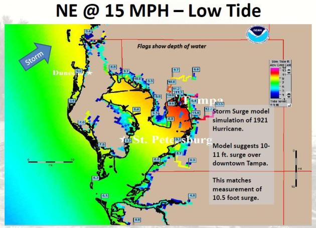 Storm Surge
. The Tarpon Springs Hurricane of 1921 created a 10-11 foot storm surge over downtown Tampa.
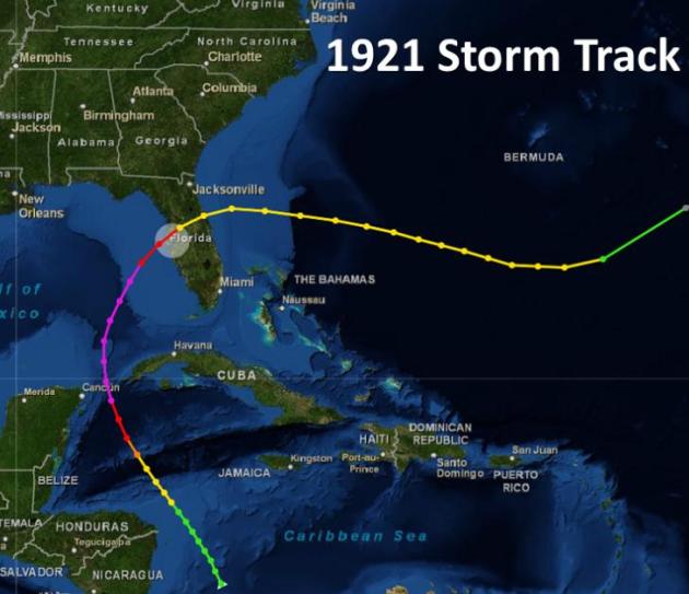 Tarpon Hurricane Track
. The late October 1921 hurricane scored a direct hit on the Tampa/St. Petersburg area, tapping warmth and moisture from the Gulf of Mexico. Map courtesy of the Tampa NWS.
San Antonio Texas: "Fortified" Campus Being Built. A collection of tornado-proof buildings on a college campus?
Mysanantonio.com has details on new buildings going up able to withstand EF-1 force winds: “
The primary considerations for the site were high winds, hail, flood and wildfire. It’s not in a flood plain, and should be able to withstand an F1 tornado with features such as additional structural steel and stronger windows. The electrical system should be able to handle electrical surges from lightning strikes.” “The 300,000-square-foot campus broke ground in the spring and should be completed in June 2012.”
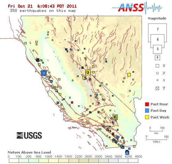
Earthquake Updates. With the recent significant tremors in the San Francisco Bay area I thought I'd post the
URL for quake updates from USGS.

 Indian Summer Rerun
. Not bad at all for late October. We're 59 days away from the Winter Solstice, and here we are, basking in the 60s, with a shot at 70 on Sunday. Under a perfect-blue sky Friday highs ranged from 50 at Grand Marais to 61 in the Twin Cities, 62 at St. Cloud and a balmy 69 at Redwood Falls.
Paul's Conservation Minnesota Outlook for the Twin Cities and all of Minnesota:
TODAY: Plenty of sun, very nice. Winds: NW 3-8. High: 62
SATURDAY NIGHT: Patchy clouds, isolated shower. Low: 47
SUNDAY: Partly sunny and unseasonably warm. An isolated shower or T-shower can't be ruled out. High: 67
MONDAY: More clouds than sun, cooler. Low: 44. High: 58
TUESDAY : Chance of a light shower or two. Potential for significant rain has diminished. Low: 40. High: 50
WEDNESDAY: Intervals of sun, cool breeze. Low: 36. High: 51
THURSDAY: Partly sunny, turning breezy and milder. Low: 38. High: 54
FRIDAY: Mix of clouds and sun, brisk. Low: 37. High: 52
* Odds favor dry weather for Halloween this year, high pressure providing highs from 48-54, Trick or Treat temperatures in the 40s - little chance of any precipitation.
Dazed and Amazed
We're still in the weather honeymoon phase; Mother Nature blowing soft, lukewarm Indian Summer kisses in our general direction. If it isn't love it's a full-blown case of meteorological infatuation. We'll all be smitten this weekend, highs near 60 today, mid 60s Sunday may soften the final score of the Vikes game. A rare clap of late October thunder Sunday signals the arrival of cooler air next week. By Tuesday it will feel like autumn again, although I still don't see a genuine cold front through the first week of November. No significant precipitation either. Is this a trend in the making? The answer appears to be "increasingly yes".
CPC, the Climate Prediction Center, is forecasting colder and wetter December into February. Based on a persistent La Nina and expected high pressure roadblocks over Alaska and Greenland this winter - I suspect our drought will continue; the biggest storms sailing south/east of Minnesota. We'll get the cold hangover; Chicago and Des Moines get the headline-grabbing snow storms. Not a flake of snow expected nearby through Halloween.
Will November 2011 be like last year (9.8" snow!) or 2009 (a trace)? I'm leaning more toward 2009. Stay tuned.
The Vanishing Arctic. Here's a remarkable (and deeply troubling) story from
project-syndicate.org: "
BERLIN – Largely unnoticed, a silent drama has been unfolding over the past weeks in the Arctic. The long-term consequences will far outstrip those of the international debt crisis or the demise of the Libyan dictatorship, the news stories now commanding media attention. The drama – more accurately, a tragedy – playing out in the North is the rapid disappearance of the polar ice cap, the Arctic Ocean’s defining feature. In September, the sea-ice cover on the Arctic Ocean melted all the way back to the record-low level recorded in September 2007. At 4.4 million square kilometers, it was the smallest ice cover since satellite observations began 40 years ago, with 40% less ice than in the 1970’s and 1980’s. Back in 2007, the record low stunned climate scientists, who considered it an outlier in an otherwise much slower decline in sea-ice cover. We blamed unusual wind conditions in the Arctic that year. But satellite data since then have proven us wrong. This year, we reached the same low level without exceptional wind conditions. It is now clear that we are not just seeing a steady decline of sea-ice cover, but a rapidly accelerating decline. If this continues, we will probably see an ice-free North Pole within the next 10-20 years. Yes, that sounds shocking. But there is good reason to fear that the rate of decline will indeed continue to rise, and that satellite images of a blue polar ocean will grace the covers of news magazines sooner rather than later."
Global Warming Study Finds No Grounds For Climate Skeptic's Concerns. The story from the U.K.
Guardian: "
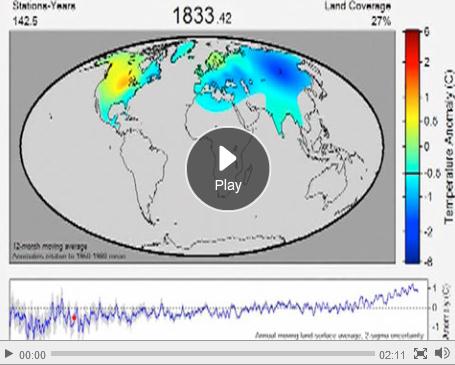
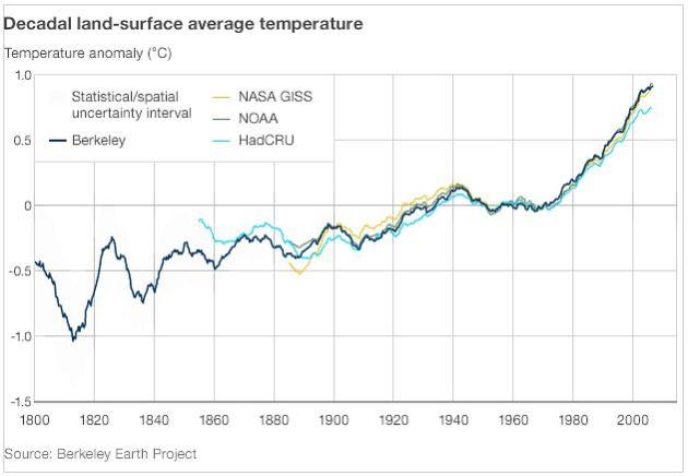
The world is getting warmer, countering the doubts of climate change sceptics about the validity of some of the scientific evidence, according to the most comprehensive independent review of historical temperature records to date. Scientists at the University of California, Berkeley, found several key issues that sceptics claim can skew global warming figures had no meaningful effect. The Berkeley Earth project compiled more than a billion temperature records dating back to the 1800s from 15 sources around the world and found that the average global land temperature has risen by around 1C since the mid-1950s. This figure agrees with the estimate arrived at by major groups that maintain official records on the world's climate, including Nasa's Goddard Institute for Space Studies in New York, the US National Oceanic and Atmospheric Administration (Noaa), and the Met Office's Hadley Centre, with the University of East Anglia, in the UK. "My hope is that this will win over those people who are properly sceptical," Richard Muller, a physicist and head of the project, said. "Some people lump the properly sceptical in with the deniers and that makes it easy to dismiss them, because the deniers pay no attention to science. But there have been people out there who have raised legitimate issues."
Climate Skeptic Admits He Was Wrong To Doubt Global Warming Data. More from the
L.A. Times: "
Remember when scientists who had cast doubt on global temperature studies boldly embarked on an effort to "reconsider" the evidence? They have. And they conclude that their doubt was misplaced. UC Berkeley physicist Richard Muller and others were looking at the so-called urban heat island effect -- the notion that because more urban temperature stations are included in global temperature data sets than are rural ones, the global average temperature was being skewed upward because these sites tend to retain more heat. Hence, global warming trends are exaggerated. Using data from such urban heat islands as Tokyo, they hypothesized, could introduce "a severe warming bias in global averages using urban stations." In fact, the data trend was "opposite in sign to that expected if the urban heat island effect was adding anomalous warming to the record. The small size, and its negative sign, supports the key conclusion of prior groups that urban warming does not unduly bias estimates of recent global temperature change."
Climate Study Raises Heated Debate. One more perspective of the "Muller paper", this time from the
BBC: "The
Berkeley Earth Project's new analysis of the global temperature record,
which I covered on Thursday, raises a number of questions concerning the science and the politics of climate change, and the ways in which science should be conducted. The headline conclusion - that the Earth's surface is indeed getting warmer and that the 20th Century did indeed see a pattern of warming, slight cooling and warming again - is hardly a surprise. But in the febrile atmosphere of "the climate debate", its significance lies not only in its conclusions, but in who's done it and what they've found. At the heart of the
"Climate Gate" issue lay the allegation that researchers at the University of East Anglia (UEA) and their peers elsewhere had basically cooked the books. They'd twisted, hidden, manipulated and otherwise distorted
their record of the Earth's temperature, it was said, for whatever reason - to save their careers, promote their green ideology or further the cause of world government."
Warming Trend. The Berkeley group's record of global land temperature mirrors existing ones closely. Source: BBC and the Berkeley Group.












No comments:
Post a Comment