1.3" Central Park in New York City. Snowiest October since records were first kept in 1869.
Thunder-snow reported at Harrisburg, PA yesterday.
15" snowfall estimates in Lancaster, PA. (thanks to Volker Kruhoeffer for the snow report).
42 F. high in Baltimore and Washington D.C. (Reagan Airport) Saturday, coldest October 29 ever recorded.
Snow has fallen in Washington D.C. only 15 times in October since the late 1800s (Capital Weather Gang).

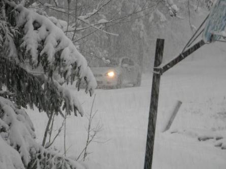
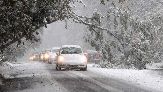
Snow Blitz! A scene from Lodi, New Jersey. Governor Chris Christie declared a State of Emergency for much of New Jersey. Photo courtesy of the Daily Mail.
Earliest New York City one-inch snowfall since records began.
Pennsylvania 84-year-old man dies as tree crashes into his home as he has had a nap. Another dead in Connecticut
More than 250,000 customers lost power in Pennsylvania and Maryland
More than 1,000 flights in or out of America cancelled
Experts predict up to 10 inches of snow to fall across North East
Only fourth time since Civil War that snow has fallen in NYC in October
“It is unusual to have a storm of this intensity affect the mid-Atlantic and the Northeast” at this time of year, said National Weather Service spokesman Chris Vaccaro. “This is more like a February storm as opposed to an October storm.” - from a Washington Post article on Saturday's freakish October snowstorm.

Historic Northeast Storm. Saturday's storm is breaking records from Virginia to Maine, impacting tens of millions of Americans. AccuWeather.com has more details: "Heavy, tree-breaking, travel-snarling, record-breaking snow will continue to spread across the Northeast tonight. The snow is moving southwest to northeast across the region, creating an early season winter wonderland but a nightmare for travelers and power companies. By the time the snow winds down Sunday morning, between 6 and 12 inches of snow will cover places from central and eastern Pennsylvania to eastern Maine."
Atmospheric Omen? I'm starting to wonder if another La Nina pattern may just favor the biggest storms for the east coast again this winter. It's too early to reach profound conclusions - we won't really know what kind of blocking patterns are setting up until late November or December. But the east coast just got pasted by heavy rain, snow and coastal flooding - a few more coastal storms are brewing over the next 1-2 weeks, and this may be a premonition of wild and wintry storms to come from Atlanta to D.C. to New York and Boston. We'll see. Just a gut feel (nausea?)

I Thought This Thing Had All-Wheel Drive! Thanks to WeatherNation meteorologist Kristin Clark, who braved moderate snow in State College, PA to take in a Penn State - Illinois football game with some friends. No, she wasn't the one getting pushed out of a snowy rut.
PUBLIC INFORMATION STATEMENT
SPOTTER REPORTS
NATIONAL WEATHER SERVICE NEW YORK NY
549 PM EDT SAT OCT 29 2011
THE FOLLOWING ARE UNOFFICIAL OBSERVATIONS TAKEN DURING THE STORM
THAT HAS BEEN AFFECTING OUR REGION. APPRECIATION IS EXTENDED TO
HIGHWAY DEPARTMENTS...COOPERATIVE OBSERVERS...SKYWARN SPOTTERS AND
MEDIA FOR THESE REPORTS. THIS SUMMARY IS ALSO AVAILABLE ON OUR HOME
PAGE AT WEATHER.GOV/NYC
...RECORD OCTOBER SNOWFALL AMOUNT SET FOR CENTRAL PARK NY...
AS OF 2 PM TODAY...CENTRAL PARK RECORDED 1.3 INCHES OF SNOWFALL.
SINCE SNOWFALL RECORDS BEGAN IN 1869...AN INCH OF SNOWFALL HAS NEVER
BEEN RECORDED IN THE MONTH OF OCTOBER. THE LAST TWO TIMES THAT
MEASURABLE SNOW FELL IN THE MONTH OF OCTOBER WAS...OCTOBER 21 1952
WITH 0.5 INCHES AND OCTOBER 30 1925 WITH 0.8 INCHES.
THEREFORE...THIS BREAKS THE DAILY RECORD FOR SNOWFALL IN OCTOBER AND
THE MOST SNOWFALL EVER RECORDED IN THE MONTH OF OCTOBER.
********************STORM TOTAL SNOWFALL********************
LOCATION STORM TOTAL TIME/DATE COMMENTS
SNOWFALL OF
/INCHES/ MEASUREMENT
CONNECTICUT
...FAIRFIELD COUNTY...
RIDGEFIELD 10.0 450 PM 10/29 PUBLIC
DANBURY 8.9 500 PM 10/29 SKYWARN SPOTTER
MONROE 7.0 249 PM 10/29 PUBLIC
SHELTON 6.8 530 PM 10/29 PUBLIC
BROOKFIELD 6.0 500 PM 10/29 SKYWARN SPOTTER
GREENWICH 5.0 351 PM 10/29 SKYWARN SPOTTER
NEWTOWN 5.0 323 PM 10/29 SKYWARN SPOTTER
NORWALK 3.5 330 PM 10/29 PUBLIC
BRIDGEPORT 2.5 326 PM 10/29 COOP OBSERVER
DARIEN 2.0 1255 PM 10/29 SKYWARN SPOTTER
STAMFORD 2.0 145 PM 10/29 SKYWARN SPOTTER
STRATFORD 1.3 119 PM 10/29 PUBLIC
...MIDDLESEX COUNTY...
HADDAM 2.0 523 PM 10/29 PUBLIC
...NEW HAVEN COUNTY...
OXFORD 8.5 531 PM 10/29 PUBLIC
SEYMOUR 7.0 457 PM 10/29 PUBLIC
NORTH HAVEN 6.2 536 PM 10/29 SKYWARN SPOTTER
MERIDEN 4.0 412 PM 10/29 PUBLIC
NEW HAVEN 1.1 233 PM 10/29 PUBLIC
EAST DERBY 1.0 234 PM 10/29 PUBLIC
NEW JERSEY
...BERGEN COUNTY...
TENAFLY 4.3 516 PM 10/29 COOP OBSERVER
SADDLE BROOK 4.3 532 PM 10/29 SKYWARN SPOTTER
RIDGEWOOD 4.0 532 PM 10/29 SKYWARN SPOTTER
MIDLAND PARK 4.0 336 PM 10/29 PUBLIC
RIDGEFIELD 4.0 130 PM 10/29 PUBLIC
RAMSEY 3.3 532 PM 10/29 SKYWARN SPOTTER
DUMONT 3.0 319 PM 10/29 NWS EMPLOYEE
RIVERVALE 2.5 245 PM 10/29 COOP OBSERVER
WYCKOFF 1.9 532 PM 10/29 SKYWARN SPOTTER
GARFIELD 1.2 138 PM 10/29 SKYWARN SPOTTER
...ESSEX COUNTY...
VERONA 6.0 446 PM 10/29 PUBLIC
CEDAR GROVE 5.3 452 PM 10/29 PUBLIC
WEST ORANGE 5.0 351 PM 10/29 PUBLIC
BELLEVILLE 4.9 516 PM 10/29 SKYWARN SPOTTER
NEWARK AIRPORT 2.7 300 PM 10/29 FAA CONTRACT OBSERVER
...HUDSON COUNTY...
HARRISON 3.1 530 PM 10/29 SKYWARN SPOTTER
HOBOKEN 1.0 333 PM 10/29 SKYWARN SPOTTER
...PASSAIC COUNTY...
WEST MILFORD 12.5 523 PM 10/29 SKYWARN SPOTTER
RINGWOOD 8.8 511 PM 10/29 SKYWARN SPOTTER
WAYNE 5.8 532 PM 10/29 SKYWARN SPOTTER
HAWTHORNE 3.5 424 PM 10/29 SKYWARN SPOTTER
...UNION COUNTY...
ROSELLE PARK 4.8 532 PM 10/29 SKYWARN SPOTTER
ELIZABETH 3.4 411 PM 10/29 PUBLIC
NEW YORK
...BRONX COUNTY...
BRONX 2.2 421 PM 10/29 PUBLIC
...KINGS COUNTY...
SHEEPSHEAD BAY 1.0 130 PM 10/29 SKYWARN SPOTTER
...KINGS (BROOKLYN) COUNTY...
SHEEPSHEAD BAY 2.0 442 PM 10/29 SKYWARN SPOTTER
...NASSAU COUNTY...
MINEOLA 4.0 503 PM 10/29 SKYWARN SPOTTER
NORTH MASSAPEQUA 1.0 330 PM 10/29 PUBLIC
...NEW YORK COUNTY...
NEW YORK 1.8 254 PM 10/29 PUBLIC AT W 85TH ST
...NEW YORK (MANHATTAN) COUNTY...
CENTRAL PARK 1.3 200 PM 10/29 CENTRAL PARK ZOO
...ORANGE COUNTY...
HARRIMAN 8.3 445 PM 10/29 SKYWARN SPOTTER
WARWICK 8.0 448 PM 10/29 SKYWARN SPOTTER
MONROE 7.3 530 PM 10/29 PUBLIC
MIDDLETOWN 7.0 520 PM 10/29 PUBLIC
GOSHEN 5.0 345 PM 10/29 EMERGENCY MANAGER
NEW WINDSOR 4.5 300 PM 10/29 PUBLIC
SOUTH BLOOMING GROVE 3.0 226 PM 10/29 SKYWARN SPOTTER
GREENWOOD LAKE 3.0 248 PM 10/29 PUBLIC
CORNWALL LANDING 3.0 323 PM 10/29 SKYWARN SPOTTER
NEWBURGH 3.0 225 PM 10/29 SKYWARN SPOTTER
...PUTNAM COUNTY...
MAHOPAC 6.5 432 PM 10/29 PUBLIC
BREWSTER 6.0 537 PM 10/29 SKYWARN SPOTTER
PUTNAM VALLEY 1.5 247 PM 10/29 COOP OBSERVER
...QUEENS COUNTY...
LAGUARDIA AIRPORT 1.0 200 PM 10/29 FAA CONTRACT OBSERVER
NYC/JFK AIRPORT 0.3 200 PM 10/29 FAA CONTRACT OBSERVER
...RICHMOND COUNTY...
ELTINGVILLE 0.5 100 PM 10/29 PUBLIC
...ROCKLAND COUNTY...
NEW CITY 5.0 420 PM 10/29 PUBLIC
STONY POINT 3.0 323 PM 10/29 SKYWARN SPOTTER
...SUFFOLK COUNTY...
OAKDALE 0.3 208 PM 10/29 PUBLIC
ISLIP T 200 PM 10/29 FAA CONTRACT OBSERVER
...WESTCHESTER COUNTY...
ARMONK 7.5 357 PM 10/29 PUBLIC
HASTINGS-ON-HUDSON 6.0 453 PM 10/29 PUBLIC
VALHALLA 5.0 300 PM 10/29 PUBLIC
SOMERS 4.5 422 PM 10/29 PUBLIC
VERNON PARK 4.0 255 PM 10/29 SKYWARN SPOTTER
YONKERS 4.0 256 PM 10/29 COOP OBSERVER
RYE 2.5 113 PM 10/29 PUBLIC
SCARSDALE 1.5 100 PM 10/29 SKYWARN SPOTTER
* Thanks to NOAA and Earth Networks for the NYC snowfall update.
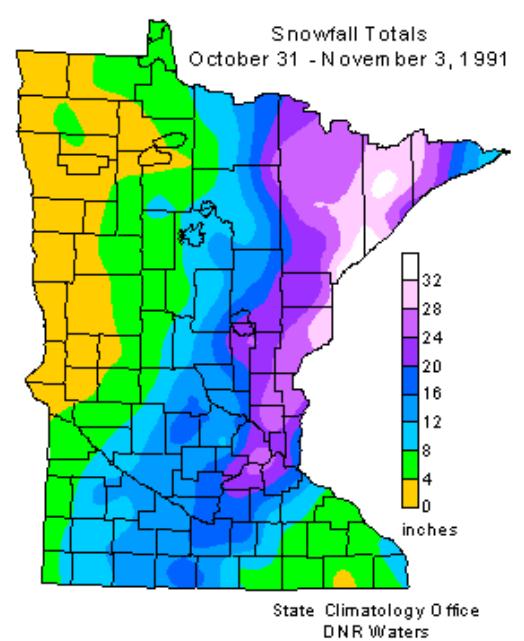
* Click here for a great recap of the Halloween Superstorm from the Minnesota State Climate Office.


1. Accident, Maryland
2. Bad Axe, Michigan
3. Badwater, California
4. Bat Cave, North Carolina
5. Bitter Springs, Arizona
6. Boos, Illinois
7. Casper, Wyoming
8. Chocolate Bayou, Texas
9. Cut Off, Louisiana
10. Deadwood, Oregon
11. Devils Elbow, California
12. Devils Elbow, Missouri
13. Devils Lake, North Dakota
14. Dripping Springs, Texas
15. Echo, Minnesota
16. Egg Harbor City, New Jersey
17. False River, Louisiana
18. Frankenstein, Missouri
19. Frostproof, Florida
20. Gnaw Bone, Indiana
21. Half Hell, North Carolina
22. Hazard, Nebraska
23. Hell, Michigan

Paul's Conservation Minnesota Outlook for the Twin Cities and all of Minnesota:
TODAY: Showers likely, cool and soggy. Winds: NW 15. High: 48
SUNDAY NIGHT: Showers taper. Low: 35
HALLOWEEN: Zombie Alert. Partly sunny. Dry. High: 52
TUESDAY: Touch of Indian Summer. Unseasonably mild. Low: 40. High: 61
WEDNESDAY: Few light showers possible. Low: 41. High: near 50
THURSDAY: Clouds linger, a little drizzle. Low: 35. High: 47
FRIDAY: Intervals of sun, brisk. Low: 33. HIgh: 48
SATURDAY: Gusty and cool, few rain showers. Low: 35. High: 46
SUNDAY: Partly sunny - better day of the weekend. Low: 32. High: 51
A Storm Like No Other
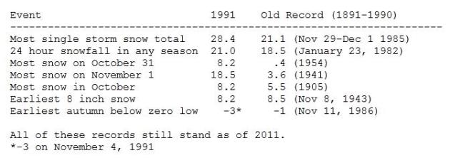
I can't remember what I did yesterday, but I will never forget Halloween, 1991. Snow was in the forecast, but it came in faster and harder, lingering a lot longer than the (worthless) computer models were predicting. Nobody envisioned the storm stalling over Lake Superior, prolonging "S+" over eastern Minnesota. My little Saab couldn't even get out of the driveway. KARE-TV's Chief Engineer rescued me in his big Suburban. Kind of embarrassing when the weather guy can't get to work. It was a humbling reminder of the limits of meteorology, a "black swan" weather event. Odds are we will never see a storm to rival the 1991 "Superstorm". Most snow from a single storm (28.4"). Earliest 8"+ snow. Earliest subzero temperature. In all 7 Twin Cities records.
Some 1-2 foot snows plastered the northeast yesterday, the earliest foot of snow on record. I suspect it's a preview: the biggest, wildest storms may track south/east of Minnesota this winter. Thanks La Nina.
Rain showers arrive today, but skies clear for Halloween - 60 possible on Tuesday, a nice start to November. A little rain Wednesday and Thursday gives way to heavy jackets by late week. No wintry jabs shaping up...yet.

Global Warming: Middle East's Vital Wet Winters Are Disappearing. The Christian Science Monitor has the story: "Winter droughts have become increasingly common in the Mediterranean region, particularly over the past 20 years, and a new study finds that global warming has driven at least half of the change. Drought conditions in this politically explosive region are expected to grow more severe over the course of the century unless countries begin to significantly reduce their emissions of heat-trapping greenhouse gases, particularly carbon dioxide, many researchers say. Those emissions come from burning fossil fuels, as well as from land-use changes. Winter storms historically have delivered most of the annual rain and snowfall to the already arid Mediterranean region. Yet precipitation measurements from the region and modeling studies point to a relatively rapid shift in the winter rain and snowfall trends that began in the 1970s, according to the study."
No comments:
Post a Comment