76 F. high in the Twin Cities Monday.
.12" rain yesterday in the metro area.
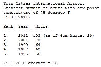
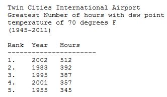
103 hours of 75+ dew points at MSP this past summer. (new record)
319 hours of 70+ dew points at MSP (all-time record is 512 hours, set during the summer of 2002).
Paul's Conservation Minnesota Outlook for the Twin Cities and all of Minnesota:
TODAY: Intervals of sun, still balmy. Winds: S 10-15. High: 78
TUESDAY NIGHT: Chance of showers late. Low: 58
WEDNESDAY: Few hours of showers likely. High: 71
THURSDAY: Mostly cloudy, windy and cooler with a few sprinkles. Low: 52. High: 65
FRIDAY: Partly sunny, feels like October. Low: 45. High: 61
SATURDAY: Sunnier day of the weekend. Nice. Low: 46. High: 64
SUNDAY: Mild start, then breezy and cooler as clouds increase. Low: 45. High: 63
MONDAY: Mix of clouds & sun, light jackets. Low: 42. High: 59
 Drop in the bucket
. Spokesman for Texas Farm Bureau, Gene Hall, tells Weather Nation TV all of the rain this weekend in Drought Stricken Texas is too little, too late. In his words, “The Wheat Crop is Toast”.
"
People in Chicago are going to want to move after this winter." - from an AccuWeather story predicting a "brutal" winter for the Midwest, including Minnesota.
Summer Moisture Spikes. Here's a
statement from the local NWS: "
The National Weather Service is forecasting a break in the high dew point temperatures over the next few days after the muggy day today. So far this summer as of 4pm August 29, there have been 319 hours of dew point temperatures of 70 degrees or higher recorded at the Twin Cities International Airport. The record is 512 hours in 2002. What really stands out are the counts of extremely muggy dew point temperatures. So far this summer as of 4pm August 29, there have been 103 hours of dew point temperatures of 75 degrees or higher. This breaks the old record of 78 hours that was set back on 2001."
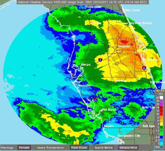
Florida Soaker. Persistent trade winds coupled with an intensifying storm overhead squeezed out as much as 10" of rain on central Florida. Doppler: NWS.
Texas Rainfall Records:
A RECORD RAINFALL OF 2.56 INCHES WAS SET AT SAN ANGELO YESTERDAY.
THIS BREAKS THE OLD RECORD OF 1.06 SET IN 1957.

 A RECORD RAINFALL OF 3.57 INCHES WAS SET AT ABILENE YESTERDAY. THIS
BREAKS THE OLD RECORD OF 1.7 SET IN 1887.
A RECORD RAINFALL OF 2.57 INCHES WAS SET AT GALVESTON YESTERDAY.
THIS BREAKS THE OLD RECORD OF 1.68 SET IN 2002.
A RECORD RAINFALL OF 5.83 INCHES WAS SET AT WACO TODAY. THIS BREAKS
THE OLD RECORD OF 3.36 SET IN 2003.
A RECORD RAINFALL OF 1.31 INCH(ES) WAS SET AT MIDLAND TODAY.
THIS BREAKS THE OLD RECORD OF 0.8 SET IN 1982
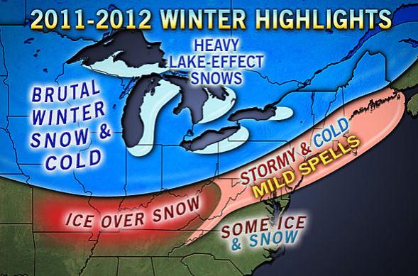
AccuWeather: A "Brutal" Winter For The Midwest? For what it's worth - I'm not convinced it's going to be that bad, but in the spirit of full disclosure, here's a story that provides a little reality check to go along with our recent spell of magical 80s. Will we be paying a steep price come January and February? I don't think we'll escape with a mild (El Nino) winter, but I also don't think we'll be subject to 86" of snow this winter. Here's an excerpt from a pretty dire outlook from
AccuWeather meteorologists: "Hands down, AccuWeather.com's long-range experts agree that the Midwest and Great Lakes region will be dealt the worst of winter this year. In terms of both snow and cold,
this winter is expected to be the worst in Chicago. AccuWeather.com Long-Range Meteorologist Josh Nagelberg even went so far as to say, "People in Chicago are going to want to move after this winter." However, for the worst of winter's cold alone, the AccuWeather.com Long-Range Forecasting Team points to Minneapolis.
* more winter outlooks
here.
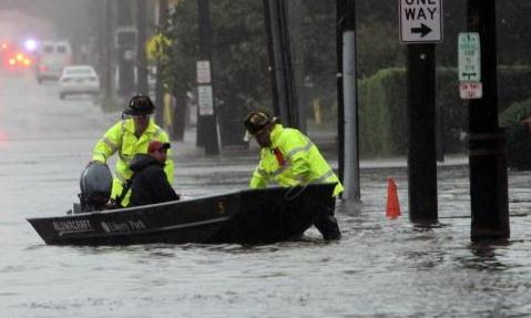
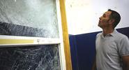
 Freedom Of The Seas Gets Rocked By Rough Weather - Damage To Public Areas
. Not a great week to be on a cruise, with reports of 10-20 foot seas in the Bahamas.
Cruiseradio.net has more details: "
Passenger’s aboard Royal Caribbean’s Freedom of the Seas got rocked last night as the ship experienced rough weather from a nor’easter that’s affecting ports along Florida’s east coast. According from a statement released by Royal Caribbean, “Sunday at approximately 7:30 p.m. after departing Port Canaveral, Florida, Royal Caribbean International’s Freedom of the Seas experienced extreme wind and sea conditions, well beyond what was forecasted. The ship experienced wind speeds more than three times what was forecast. The combination of the wind and sea conditions caused severe ship movement. At this time there have not been any serious injuries reported. The ship has sustained some damage to the public areas and guest staterooms, which in no way affect the sea-worthiness of the ship.” A passenger aboard Freedom told us “It was crazy. The ship was on it’s side, everything broke all over ship, medical emergencies all over, and people ordered to their cabins. The elevators are off, scary.” Reports are that seas exceeded 18 feet and some vessels stayed in port because of the nor’easter."
 Photo credit
: adamj4282/flickr
Team Seeks To Provide More Advance Warning On Hurricanes. Here's an interesting article on hurricane forecasting from
USA Today: "
Forecasters hope new research will give the public more advance warning of the birth of a monster hurricane. Most tropical storms and hurricanes can be forecast only about two days before their formation. A research collaboration hopes to extend that forecast by 10 days or more. The effort is timely as weather experts look for ways to combat deadly storms. This year's storm season killed dozens of Americans and led to billions of dollars in damages. Leaders of the collaboration between EarthRisk Technologies, a San Diego-based software and weather prediction company, and Colorado State University's Tropical Meteorology Project say their efforts could help better predict when an Atlantic hurricane forms. Their methods analyze past weather information and use EarthRisk's algorithms for forecasting the probability of extreme weather. "EarthRisk's ability to take decades of atmospheric data and crunch it into usable models that can then be applied to future cyclone events will be invaluable to our research," says Colorado State's William Gray, the dean of hurricane forecasting."
Hurricane-Proof Your Home For Free. Here's a story from the
Sun-Sentinel: "
A lucky few in South Florida will get, courtesy of the U.S. Government, new roofs, windows or doors to strengthen their homes against hurricanes. Broward and Palm Beach counties have several million dollars to dole out to homeowners on the lower end of the income scale. In Broward, the money will go to homeowners preparing their homes to better withstand high winds. In Palm, it will be spent to repair damage from Hurricane Wilma, which hit in 2005. "It's a great opportunity,'' said Patricia Stephenson at the non-profit Broward Alliance for Neighborhood Development (BAND). Her organization is one of two distributing $2 million for Broward, between now and August. Each homeowner could get up to $40,000, given in the form of a loan that would have to be repaid if the home were sold within 10 years. The Broward grants will go to homeowners who meet the income criteria — for a household of four, the maximum income would be $60,250 a year."
Rider On The Storm. What's it like parachuting through a severe thunderstorm? It should have been a death sentence, but one VERY lucky guy did just that - and lived to tell about it.
Damninteresting.com (my new favorite URL) has the incredible details: "
As Rankin plunged toward the earth, licks of lightning darted through the massive, writhing storm cloud below him. Rankin had little attention to spare, however, given the disconcerting circumstances. The extreme cold in the upper atmosphere chilled his extremities, and the sudden change in air pressure had caused a vigorous nosebleed and an agonizing swelling in his abdomen. The discomfort was so extreme that he wondered whether the decompression effects would kill him before he reached the ground. As the wind roared in his ears, he gasped up oxygen from his emergency breathing apparatus while resisting the urge to pull his parachute’s rip cord; its built-in barometer was designed to auto-deploy the parachute at a safe breathing altitude, and his supply of emergency oxygen was limited. Opening the chute early would prolong his descent and might result in death due to asphyxiation or hypothermia. Under normal circumstances one would expect about three and a half minutes of free-fall to reach the breathable altitude of 10,000 feet. The circumstances, however, were not normal. After falling for a mere 10 seconds, Bill Rankin penetrated the top of the anvil-shaped storm. The dense gray cloud smothered out the summer sun, and the temperature dropped rapidly. In less than a minute the extreme cold and wind began to inflict Rankin’s extremities with frostbite; particularly his gloveless left hand. The wind was a cacophony inside his flight helmet. Freezing, injured, and unable to see more than a few feet in the murky cloud, the Lieutenant Colonel mustered all of his will to keep his hand far from the rip cord."
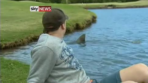
Shark-Infested Golf Course. Hey, watch those nasty water hazards!
Neatorama.com has the details: "
Hey caddy, my ball went into the water. Be a good sport and go in and get it, would you? Well, maybe not at the Carbrook Golf Club in Brisbane, Australia, where half a dozen bullsharks live in the lake. They took up residence a few years ago when a nearby river flooded, and have been breeding since then. Some of the sharks are up to ten feet long. They’ve become quite an attraction, so groundskeepers feed them to encourage them to come near the shore. Watch a video of the sharks at the link."
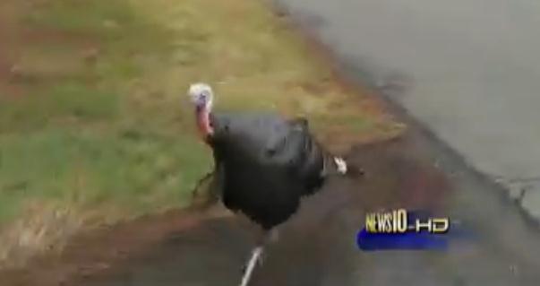
Chased By A Wild Turkey. A local TV producer got a little more than she bargained for. Here's a funny clip at
mediabistro.com: “
I would not want to be the people living here,” KXTV producer Duffy Kelly said, slamming her car door as a wild turkey pecked at the window. Kelly was out in the Arden Oaks neighborhood to investigate reports of wild turkeys terrorizing walkers and joggers in the residential area. Once Kelly found the turkeys in question, she was chased several blocks — with the camera rolling the whole way (watch the video above). “If the camera’s shaking, it’s because I’m shaking,” she can be heard saying in the video. “If my arm’s shaking, it’s because I’m scared of that turkey!”
 Rare Rainfall
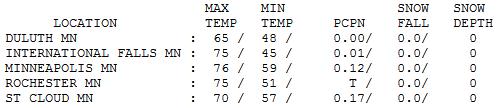
. After a sunny start a rapidly weakening cool front pushed a few showers across the state by late afternoon and evening, roughly a tenth of an inch of rain in the Twin Cities. St. Cloud reported .17" The last time we've seen half an inch or more of rain in the metro area? August 15, when 1.42" fell.

An October to Remember
In Meteorology 001 well-meaning professors teach students a) the days of the week, b) it gets colder (north) and warmer (south), and c) which finger to point to the weather map with. A tough final exam went so far as to remind students that "it gets colder in the fall." Really? OK. My college days are a blur. Just like the last 10 extraordinary, July-like days. It's been a daydream come to life: Crayola leaves ripening before our eyes, a streak of perfect, Technicolor Days - 80s, without the humidity or hummingbird-size skeeters.
Only problem: we haven't seen half an inch of rain or more since August 15 in the metro area. The drought is getting worse statewide.
Last summer brought the highest sustained humidity levels ever observed (a record 103 hours of dew points over 75 at MSP). For the record: 319 hours of dew points over 70.
A few Wednesday showers usher cooler air back into Minnesota. 60s return by late week - some 50s next week, but nothing wintry is brewing. The weather map looks like something out of mid-September; big storms and cold fronts detouring well north.
Take nothing for granted. Two years ago today MSP had a high of 40 and 3/10ths of an inch of snow.

No comments:
Post a Comment