30 F. high in the Twin Cities Thursday.
40 F: average high for November 17.
1-3" snow predicted for the Twin Cities metro on Saturday. Best chance of accumulating snow afternoon/evening hours.
Storm-Free weather on tap next Monday through Thanksgiving Day.
45 F: predicted high for Thanksgiving Day in the metro area. 50 is not out of the question.
Twin Cities "Firsts":
First....
Coating (tenth of an inch):
November 6
1" snow:
November 18
4" snow:
December 20
* Data courtesy of the National Weather Service and Minnesota State Climate Office.
"
People with SAD need four hours a day of bright light at 10 times the intensity of ordinary lighting. It's a very simple treatment, but when used regularly throughout the winter months it can take away the worst of the feelings." - BBC article on SAD, Seasonal Affective Disorder, which may affect as much as 7% of Minnesota's population.
"While it is difficult to attribute one tornado or one downpour ... to climate change, they're certainly all developing with that as a background," Phillips said. One thing is certain: Every weather event that now happens is taking place in the context of our changing environment." - Brady Phillips, NOAA
"
Extreme weather and natural disasters brought a record-breaking 90 federal disaster declarations through Oct. 28, 2011, according to the Federal Emergency Management Agency (FEMA). Extreme weather has hit nearly every state during 2011. The year also has been the costliest to insurers on record, according to the Munich Re global insurance group." - story below on extreme weather and the need for home insurance from Fox Business
Prior to this week, the USA has experienced 56 killer tornadoes this year, resulting in 548 fatalities in 14 states. Source:
SPC.
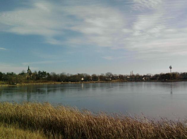
"Skim Ice". It goes without saying, but I'll say it anyway: STAY OFF THE ICE! Meteorologist Bryan Karrick captured this skim ice on Lake Benton in Cologne Thursday morning.
Slushy Inch Or Two? I'm not terribly impressed with the potential for accumulating snow in the immediate Twin Cities metro on Saturday. The storm is moving too fast, precipitation will probably begin as a cold rain and then change to wet snow by late afternoon or evening. I'm thinking an inch of slush on lawns and fields, maybe 2" over the northern and western suburbs, with some 2-4" amounts possible over central Minnesota. No cause for panic.
Record Dry Autumn? From Pete Boulay at the Minnesota State Climate Office: "
The dryness that began in late July continues to persist across Minnesota. In fact, this may wind up to be the driest meteorological autumn in the Twin Cities in the 141 year threaded record. So far from September 1 to November 17 there has been only 1.06 inches of precipitation recorded at the Twin Cities International Airport. This is 5.42 inches below normal. If the precipitation total through the end of November is less than .48 of an inch, 2011 will be the driest autumn in the Twin Cities since the threaded record began in 1871."
* The current driest September-November on record for the Twin Cities is 1889 with 1.54 inches.
Do You Have The Winter Blues? Here's a timely article from the
BBC about SAD, Seasonal Affective Disorder. As many as 7 in 100 Minnesotans may suffer from a lack of sunlight during the winter months: "
The clocks have gone back, it is noticeably darker in the afternoons and sunlight is in short supply. Are you feeling less energetic, craving more carbohydrates and chocolate and sleeping longer in bed? Then perhaps the encroaching darkness, as autumn gives way to winter, is affecting your natural body rhythms. While many animals are preparing to hibernate, who would blame people for feeling ready to go into sleep mode too? This is how nearly one in five of the UK population feel every winter between September and April, and particularly during December, January and February. They suffer from the 'winter blues', brought on by a reduction in daylight hours and a lack of sunlight."
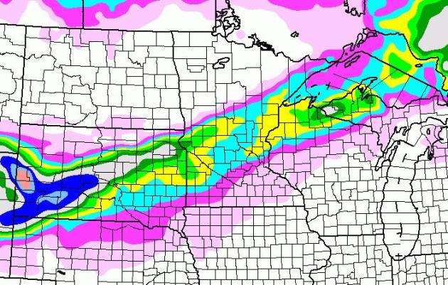
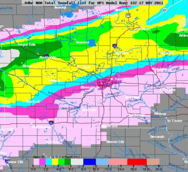
Potentially "Plowable" North/West of MSP Metro? Here's the latest NAM solution, showing some 4-6" amounts from Brainerd to Alexandria, 3-4" for St. Cloud and only 1-2" for the Twin Cities metro, especially northern/western suburbs. With temperatures just above freezing in the metro I suspect that snow will initially melt on contact, and roads will probably stay wet until dark, around 5 pm on Saturday.
Wyoming Winds. Check out some of these wind gusts from NWS Chat:
PARK COUNTY...
13 WSW CLARK... 11/17 0521 AM 102 MPH.
13 WSW CLARK... 11/17 0010 AM 90 MPH.
13 WSW CLARK... 11/16 2230 PM 76 MPH.
DEAD INDIAN PASS... 11/17 0650 AM 68 MPH.
13 WSW CLARK... 11/16 2130 PM 65 MPH.
CLARK... 11/17 0212 AM 64 MPH.
CLARK... 11/17 1000 AM 61 MPH.
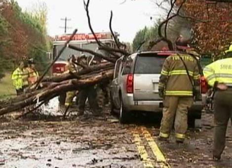
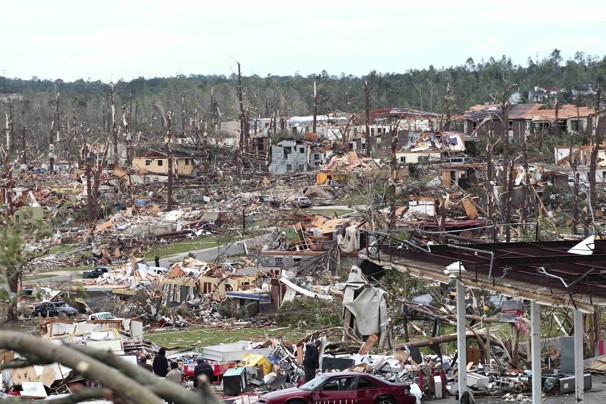
Four Dead As Severe Storms Blast Southeast. Many cities in the south see a secondary maxima of severe weather in November (as cold air sets up vigorous frontal passages), but 16 tornadoes on November 16 is a bit extreme for any year. The way this year has gone I can't say I'm surprised.
USA Today has more details: "
ROCK HILL, S.C. (AP) – A strong storm system that produced several possible tornadoes hit the Southeast on Wednesday, damaging dozens of homes and buildings. At least four people were killed and more than a dozen others were injured. Suspected tornadoes were reported in Louisiana, Mississippi, Alabama and South Carolina, and thousands of people were without power as trees and power lines were downed. In South Carolina, three people were killed and five injured when an apparent tornado swept through a rural community near Rock Hill, about 20 miles south of Charlotte, N.C. In north Georgia, an unidentified person was killed when a tree fell on a sport utility vehicle."
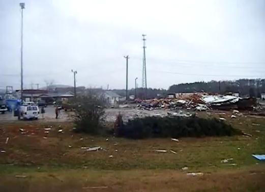
Aftermath. Here's some
YouTube footage from Thomasville, North Carolina, showing the impact of what may have been an EF-2 tornado, one of at least 16 tornadoes that touched down Wednesday from Mississippi to the suburbs of Charlotte, North Carolina. Rated PG for salty language.
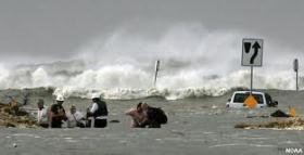
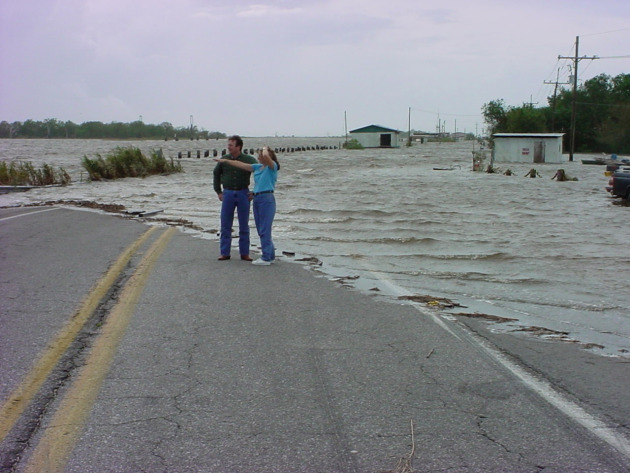
2011 Had Record-Breaking Disasters: Do You Need Home Insurance More Than Ever? Fox Business has the story: "
From spring's devastating tornadoes to Hurricane Irene to the rare October snowstorm that hit the Northeast, homeowners and their insurance companies will remember 2011 as one of the most catastrophic years on record, with billions of dollars in property damages. "It has certainly been a difficult year for folks facing catastrophes and catastrophic losses," says James Whittle, assistant general counsel and chief claims counsel for American Insurance Association (AIA). Extreme weather and natural disasters brought a record-breaking 90 federal disaster declarations through Oct. 28, 2011, according to the Federal Emergency Management Agency (FEMA). Extreme weather has hit nearly every state during 2011. The year also has been the costliest to insurers on record, according to the Munich Re global insurance group. "It was the worst tornado spring I've ever experienced," observes Paul Quinn, assistant vice president of claims communications for Farmers Insurance Group. "And I've been in the business for 35 years."
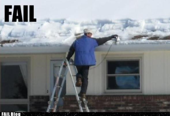
How Not To De-ice Your Roof. Please don't try this at home. An iron? Really? Check it out at
failblog.org.
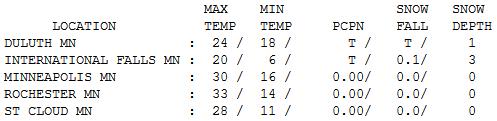
Felt Like Mid December. In spite of bright sunshine much of the day temperatures ran about 10 degrees below average on Thursday, ranging from 20 at International Falls to 24 at Duluth, 28 St. Cloud, 30 in the Twin Cities and 34 at Grand Marais (wind flow off of Lake Superior, where water temperatures are still in the upper 30s to near 40, keeping the immediate lakeshore a few degrees milder).
Paul's Conservation Minnesota Outlook for the Twin Cities and all of Minnesota:
TODAY: Intervals of sun, not as chilly. Winds: SW 10. High: 47
FRIDAY NIGHT: Mostly cloudy and dry. Low: 30
SATURDAY: Rain ends as a period of slushy snow. Coating to an inch or two possible. High: 37
SATURDAY NIGHT: Wet snow tapers to flurries. Some wet/slushy roads may become icy. Low: 20
SUNDAY: Slippery start? Sun returns - cold breeze. High: 31
MONDAY: Clouds increase, probably dry. Low: 23. High: 37
TUESDAY: Plenty of sun, milder. Low: 26. High: 41
WEDNESDAY: Partly sunny, no travel headaches. Low: 31. High: 45
THANKSGIVING DAY: Dry Thanksgiving. Clouds increase. Low: 33. High: 46
Deepening Drought
Remember when an inch or two of snow was considered "flurries"? Now we have dueling Dopplers, breathless BREAKING NEWS! promos, reporters standing out on the freeway, reminding us what snow looks like. I find that very helpful.
Timing (and temperature) is critical. An inch of snow, at 6 am on a Tuesday, with an air temperature of 15 F, is far icier and more dangerous than 4" at 30 F on a Saturday evening.
What is it about the first snow? "I have to get my snow-legs back Paul!" Me too.
A cold rain Saturday changes to wet snow; a quick 1-2" possible, especially metro area. Some 4"+ amounts are possible over central and western Minnesota, potentially "plowable" for St. Cloud. One model prints out over 8" for Alexandria. We'll see. Plan on wet roads through the afternoon in the immediate metro, where this may be more of a nuisance accumulation of slush.
We could use a good storm right about now. Since September 1 the metro area has seen a little over 1" of rain. Southern MN is running a 5-9" rainfall deficit. Not good. This may wind up being the driest meteorological autumn in 141 years.
Finally, Saturday is the only chance for accumulating snow all month. The storm track stays well south/east of Minnesota next week - good travel weather close to home. Thanksgiving highs: mid 40s.
Separating Signal And Noise In Climate Warming. The story is at
Science Codex: "
Recently, a number of global warming critics have focused attention on the behavior of Earth's temperature since 1998. They have argued that there has been little or no warming over the last 10 to 12 years, and that computer models of the climate system are not capable of simulating such short "hiatus periods" when models are run with human-caused changes in greenhouse gases. "Looking at a single, noisy 10-year period is cherry picking, and does not provide reliable information about the presence or absence of human effects on climate said Benjamin Santer, a climate scientist and lead author on an article in the Nov. 17 online edition of the Journal of Geophysical Research (Atmospheres). Many scientific studies have identified a human "fingerprint" in observations of surface and lower tropospheric temperature changes. These detection and attribution studies look at long, multi-decade observational temperature records. Shorter periods generally have small signal to noise ratios, making it difficult to identify an anthropogenic signal with high statistical confidence, Santer said."
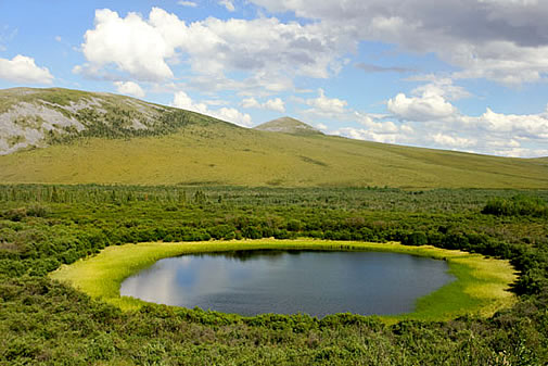
Global Warming Contributes To Melting Permafrost. The
John Hopkins News-Letter has the story: "
One of the harshest realities of global warming is its potential to feed into itself. A recent study by researchers at the Lawrence Berkeley National Laboratory in California suggests that melting permafrost may affect the atmospheric greenhouse gas concentration. The team studied this phenomenon in two permafrost samples from Hess Creek, Alaska, which had been frozen for 1,200 years. "Permafrost" refers to soil that has remained frozen over a large period of time — thousands or hundreds of thousands of years. The soil remains filled with the original dead plants and organisms it once contained, providing an excellent history of the sample's location. In this case, the experimenters thawed the samples over a period of days at a temperature of 41 degrees Fahrenheit to stimulate the natural melting of permafrost globally due to atmospheric warming." Photo above courtesy of NASA.
Climate Change: A Threat To U.S. Security. Discovery News has the story: "
The United States' Department of Defense needs to know more about how climate change affects global security, recommends a report by the the department's science advisers, the Defense Science Board (DSB). "Changes in climate patterns and their impact on the physical environment can create profound effects on populations in parts of the world and present new challenges to global security and stability," wrote Defense Science Board co-chairs, Larry Welch and Willian Howard in a letter preceding the DSB report, Trends and Implications of Climate Change for National and International Security. “Failure to anticipate and mitigate these changes increases the threat of more failed states with the instabilities and potential for conflict inherent in such failures,” the DSB co-chairs warned. "
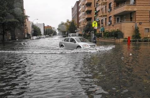
New York Should Prepare For Hotter Summers, Snowier Winters, Severe Floods From Global Warming: Report.
The Daily News has the story: "
ALBANY, N.Y. - Devastating floods like those caused in upstate New York by the remnants of Hurricane Irene and Tropical Storm Lee are among the climate change effects predicted in a new report written by 50 scientists and released Wednesday by the state's energy research agency. The 600-page report called ClimAID, intended as a resource for planners, policymakers, farmers and residents, says New Yorkers should begin preparing for hotter summers, snowier winters, severe floods and a range of other effects on the environment, communities and human health. It was written by scientists from Cornell University, Columbia University and the City University of New York and funded by the New York State Energy Research and Development Authority. "The past year was a good teachable moment in terms of the types of impacts we anticipate with climate change," said Art DeGaetano, a climate expert from Cornell who was one of the report's authors. "What we show in the report is that winters will tend to get wetter and summers drier. Conditions this year were textbook for that. Farmers had a tough time getting into wet fields this spring, then there were droughts. The flooding from Irene and Lee brought the classic types of impacts we project to occur in the report."
Climate Change: Sea Rise Could Kill Vital Marshes. The story from The
San Francisco Chronicle: "
The critical tidal marshes of San Francisco Bay - habitat for tens of thousands of birds and other animals - will virtually disappear within a century if the sea rises as high as some scientists predict it will as a result of global warming. The sea would inundate the coastline and eliminate 93 percent of the bay's tidal wetlands if carbon emissions continue unchecked and the ocean rises 5.4 feet, as predicted by scientists under a worst-case scenario, according to a new study by PRBO Conservation Science."


No comments:
Post a Comment