51 F. high in the Twin Cities yesterday.
38 mph: peak wind gust on Tuesday in the metro area (reported at 4:53 pm at MSP International).
March 23, 2011:
last "plowable" snowfall of 2" or more in the Twin Cities (4.1" fell at MSP).
7+ "plowable" snowfalls of 2" or more during an average winter season (MN State Climate Office).
11 plowable snowfalls (2" or more) fell last winter in the metro area.
Mostly rain expected in the metro area Saturday.
Plowable snow for parts of central and northern Minnesota, some 4-8"+ amounts are possible.
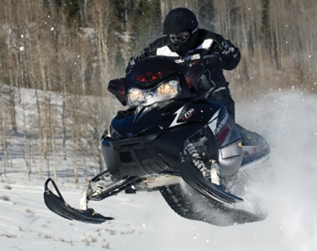
6.1" snow predicted for Brainerd on Saturday.
 Fire Up The Sleds?
 Using the Cobb Method for estimating snowfall amounts (and GFS data) 6.1" of snow is predicted for the Brainerd area - the snow tapering off rapidly Saturday evening.
 28,385 fires
 in Texas this year, which burned 3.97 million acres, destroying 2,909 homes, killing 10 people, including 4 firefighters. 38,000+ homes were saved, many by volunteer firefighters. Source:
Star Telegraph.
"No sun--no moon!
No morn--no noon!
No dawn--no dusk--no proper time of day--
No sky--no earthly view--
No distance looking blue--
No road--no street--no "t'other side this way"--
No end to any Row--
No indications where the Crescents go--
No top to any steeple--
No recognitions of familiar people--
No courtesies for showing 'em--
No knowing 'em!
No traveling at all--no locomotion--
No inkling of the way--no notion--
"No go" by land or ocean--
No mail--no post--
No news from any foreign coast--
No Park, no Ring, no afternoon gentility--
No company--no nobility--
No warmth, no cheerfulness, no healthful ease,
No comfortable feel in any member--
No shade, no shine, no butterflies, no bees,
No fruits, no flowers, no leaves, no birds--
November!"
- Thomas Hood
"
Evidence-based research indicates that what we are experiencing is an emerging new class of disasters due to changes in our climate." - article on an apparent increase in extreme weather in the Sydney Morning Herald.
"Global warming is almost the story that’s too big to cover … and too big to absorb. It takes a long time for anyone who is not a climate scientist to really accept it and mentally assemble all the hard new realities we are learning about. For journalists, this means that each month, in effect, new waves of people show up saying, “OK, I guess it’s real. Now what was that again — what you reported five years ago?” - Bill Blakemore from ABC News in a story below.
“
We went 6,694 nautical miles and never touched one piece of ice,” Thoreson said. “That tells me something is changing, even in my 20 years of experience in the Arctic. We now are 7 billion humans gaming the system. We are forcing the cycle.” - story on arctic exploration in the Des Moines Register.
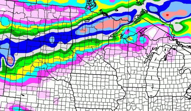
Looking More Impressive. The trend is for more snow, but confining that snow to central and northern Minnesota, the storm tracking 100 miles too far west for heavy snow in the immediate Twin Cities metro on Saturday. Models hint at an inch or two for St. Cloud, but closer to 6" for Brainerd, maybe a band of 8-12" from near Bemidji into the Minnesota Arrowhead. The map above is from the GFS model. Stay tuned...
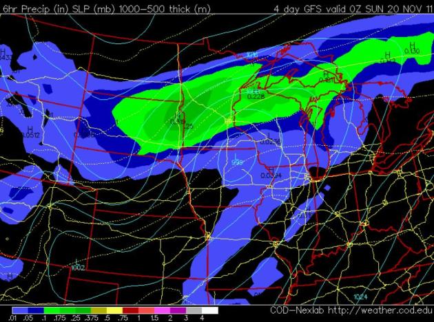 Saturday Evening Weather Map
. The latest GFS
model prints out a storm near Waterloo, Iowa at 6 pm Saturday, tracking too close to the MSP
metro for heavy snow here - but a band of moderate to heavy snow may set up from near Windom, Wadena, Detroit Lakes and Alexandria to Brainerd, Aitkin, Crosby and the Minnesota Arrowhead, perhaps 6-10 hours of significant snow over central and northern Minnesota before winds shift to the northwest and flurries taper off Saturday evening.
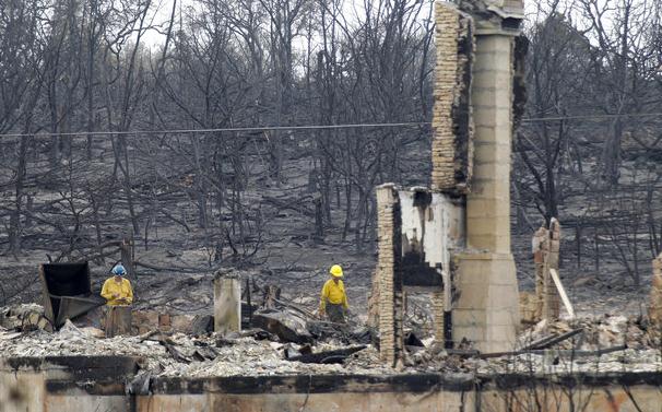 Historic Fire Season Ends This Week In Texas, But Officials Brace For Worse
. The
Star-Telegraph has a summary of the incredible drought and fire year Texas has endured: "
The unprecedented Texas fire season that incinerated 3.97 million acres, destroyed 2,909 homes and killed 10 people, including four firefighters, officially ends Tuesday. The bad news is that the next burning season starts Wednesday and, with a historic drought expected to persist at least through May, state fire officials are already concerned about Round Two. "It's a very ominous future that we have out there. Things are bad, but they are forecast to get worse," said Tom Boggus, director of the Texas Forest Service, which coordinated the response to the 28,385 fires. State climatologist John Nielsen-Gammon expects the drought to be exacerbated by a drier- and warmer-than-normal winter. "I think it will be hard for most of the state to recover from the drought since we are so far in the hole right now," he said. The drought depleted grass fuels, but dead trees, particularly junipers in West and Central Texas, will be a complicating factor next year, said Tom Spencer, director of predictive services for the Forest Service."
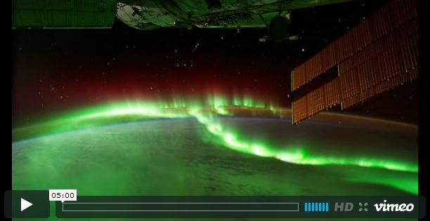
NASA Time Lapse Of Earth Is Actually Mesmerizing. Here's a terrific article and incredible time lapse of the aurora from
CNET.com: "
Yet this particular piece of footage, taken from the International Space Station between August and October this year, is curiously mesmerizing. Taken with a special low-light 4K camera, it manages to show the world as, well, other-worldly. Posted to Vimeo by the film's editor, Michael Koenig, it melds the passing of time over various continents and timezones into a quite stunning impression of a planet that still enjoys life and beauty, even if it's not always immediately visible. Even the Northern Lights seem even more magical that usually promised. It's a five-minute whole that somehow manages to remove the mind from the deep, dark hole of financial crises, political debates, bankrupt nations and crushing inequality that is occurring beneath the lights and the clouds."
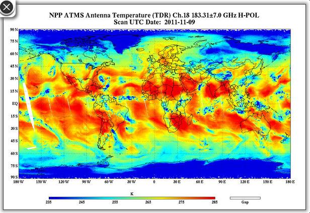 NASA Climate Satellite Takes First Pictures
.
Space.com has the article: "
NASA's new climate and weather observing satellite is settling in to its new orbit high above the Earth and running through its instruments to make sure they all check out. During this process, it sent back its first science data: an image of water vapor in the lower atmosphere. The National Polar-orbiting Operational Environmental Satellite System Preparatory Project (NPP) carries five instruments that are aimed at improving day-to-day weather forecasting while extending the record of many long-term observations of Earth's climate. This record, which range from the ozone layer and land cover to atmospheric temperatures and ice cover, are critical for understanding and predicting changes in global climate."
Wind Energy Creating A Problem With Military And Weather Radar. This is (increasingly) an issue:
turbulence around wind farms showing up on Doppler radar - which can be a real problem when strong/severe storm cells are passing over these areas - making it difficult, if not impossible, to distinguish the wake effect from wind turbines from actual severe storms.
Physorg.com has the story
: "
With the push for creating green energy, giant windmill farms are becoming more and more common for electricity production. However, the National Weather Service and the United States Air Force say these wind farms are creating much more than energy, and are making their jobs more difficult whhen it comes to detecting storms and keeping aircraft safe."
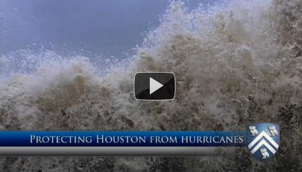 Protecting Houston From Hurricanes
.
The Cypress Times has an interesting story: "
HOUSTON, TX - To protect Houston and Galveston from future hurricanes, a Rice University-led team of experts recommends building a floodgate across the Houston Ship Channel adding new levees to protect densely populated areas on Galveston Island and the developed west side of Galveston Bay. The team also recommends creating a 130-mile-long coastal recreation area to sustainably use wetlands that act as a natural flood barrier. The recommendations appear in a new report this month from Rice University's Severe Storm Prediction, Education and Evacuation from Disasters (SSPEED) Center. The report follows more than two years of research into lessons learned from Hurricane Ike, which made landfall at Galveston Island in September 2008. Ike caused 112 U.S. deaths and is the third-costliest storm in U.S. history, with damages estimated at $30 billion."
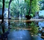
The Long Road To Recovery After Hurricane Irene. Here's an quote from an interesting article at
Emergency Management: "
In New Jersey, Mary Goepfert, public information officer for the state’s Office of Emergency Management, said residents were mostly prepared. “During our evacuation planning we had done some behavioral studies where people indicated they would leave if asked — and they did,” she said. But that amount of rain was unprecedented. Goepfert said in addition to a rainy August, the week prior to Irene, a heavy rain saturated the ground even more. “The areas that flooded had experienced flooding before but we also had some areas that either had not had flooding in a number of years or they had built systems to withstand flooding, and even those systems got overcome by the sheer volume of water.” Although people evacuated when asked to, some weren’t equipped with essentials when entering shelters. “The one thing I would do is have people be more prepared for the conditions when they get to a shelter,” Goepfert said."
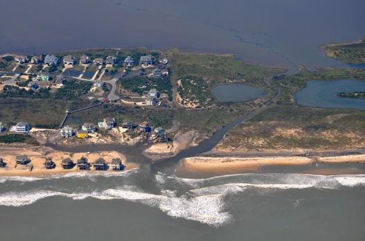
Hurricane Irene Put The Brakes On A Banner Year. From the
outerbanksvoice.com: "
Economic numbers released by The Outer Banks Chamber of Commerce offer little solace to Dare County residents and business owners, although there are signs that construction and visitation are rebounding. Occupancy rates — a measure of how many motel rooms, campgrounds and rental cottages are filled by visitors — showed healthy growth on the entire Outer Banks in July, but August and September figures reflect steep drops in visitation because of Hurricane Irene. The storm hit the barrier islands in late August and cut the highway on Hatteras Island. It was reopened last month. “It was really knocking the door down this year until, of course, that storm hit,” said Chamber President John Bone. “We would have had a huge year.”
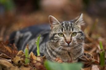
How Dogs Evolved Into Our Best Friends. Here's a fascinating story from
NPR: "
Dogs have aided humans for thousands of years. Man's best friend has provided protection, companionship and hunting assistance since the days of the earliest human settlements. But how and when dogs evolved from wolves is a matter of debate. Naturalist Mark Derr says there are two main schools of thought: Some researchers believe that humans domesticated wolves who were scrounging around their villages for trash. Others think that humans were taking care of wolves from the time they were puppies — until enough puppies were tamed and they somehow then evolved into dogs. "Neither explanation seems satisfactory," writes Derr in How the Dog Became the Dog — From Wolves to Our Best Friends. "That is why there's no consensus." (photo courtesy of istockphoto.com).
 Disaster Prep For Pet Owners.
 Here's some useful information from
zootoo.com: "
If a natural disaster is coming your way – be it hurricane, tornado, or snow storm – do you have an emergency plan in place for you and your family, including your pets? More than one third of American cat and dog owners don't have any kind of disaster preparedness plan to fall back on, according to the American Society for the Prevention of Cruelty to Animals. But more than 85 percent of dog owners and 81 percent of cat owners intend to bring their pets along with them in an event of an evacuation, according to a recent study the ASPCA conducted. Following through on that plan might not always be possible, pet owners should know, since the American Red Cross does not allow companion animals – aside from service animals – to stay with their owners in its evacuation shelters. But there are certain preparatory measures and steps pet owners can take to ensure that their pet will be in the post possible position if a disaster does strike home."
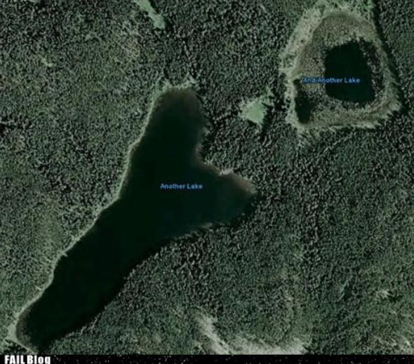 "Another Lake".
 Somehow, in the Land of 10,000 Lakes seeing a Google Map showing "Another Lake" and "And Another Lake" strikes a (funny) cord. Now I've officially seen everything, thanks to
failblog.org.
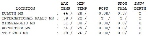
Clipped Again. A reinforcing cold front dragged a colder airmass into Minnesota, whipped along by 30+ mph wind gusts Tuesday afternoon. Highs ranged from 39 at International Falls to 49 at St. Cloud, 51 in the Twin Cities and 54 at Rochester.
 Paul's Conservation Minnesota Outlook for the Twin Cities and all of Minnesota:
TODAY: Cold, sunny start. Increasing PM clouds, breezy. Winds:
W 10-20. High:
36
WEDNESDAY
NIGHT:
Partly cloudy - feels like early December. Low:
19
THURSDAY: Plenty of chilled sun - still brisk. High: 37
FRIDAY: Clouds increase, not as chilly. Low: 29. High: 44
SATURDAY: Cold rain ends as a little wet snow. Few inches snow north? Low: 33. High: 38
SUNDAY: Clearing. Better travel day, but cold. Low: 21. High: 31
MONDAY: More clouds than sun, cooler than average. Low: 20. High: 36
TUESDAY: Intervals of sun, good travel day. Low: 24. High: 38
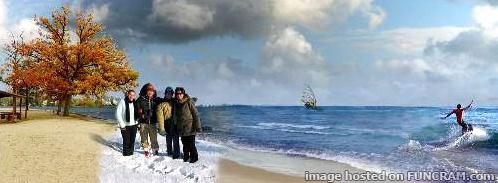
This unique, 4-season montage photo is courtesy of
funcram.com.
Saturday Snow Up North
"Colder with some snow." That's my winter outlook. How much and when? That's very much up in the air. We're long overdue for snow, and the first accumulating snow event of the winter season may be shaping up for Saturday. It'll move quickly, with enough warm air in place for mostly rain from the Twin Cities on south and east.
The ideal storm track for heavy snow in the metro area runs from Des Moines to La Crosse to Eau Claire. Saturday's storm should track closer to MSP, pulling in enough warm air for a cold rain. Farther north and west precipitation may fall as mostly snow for much of central and northern Minnesota, where enough snow may fall to shovel and plow. Hey, I've gone almost 7 months without saying "plowable snow".
It's too early to celebrate (or panic), but if you are traveling north/west of St. Cloud on Saturday check the Star Tribune blog for the very latest updates. I don't think this will be a big deal for the Twin Cities but some 4"+ amounts are possible from Brainerd to Duluth, a few towns could wind up with over 8" of fresh snow by Saturday night.
Skies clear Sunday - I don't see any stormy complications next week (a storm passes south on Wednesday). Highs may top 50 Thanksgiving Day; still no brutal arctic air in sight.
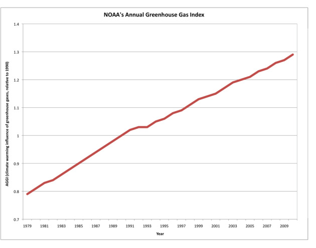
NOAA Greenhouse Gas Index Continues Rising. Here's an excerpt of a recent
press release from NOAA: "The AGGI includes methane and nitrous oxide, for example, greenhouse gases that are emitted by human activities and also have natural sources and sinks. It also includes several chemicals known to deplete Earth’s protective ozone layer, which are also active as greenhouse gases. The 2010 AGGI reflects several changes in the concentration of these gases, including:
- A continued steady increase in carbon dioxide: Global carbon dioxide levels rose to an average of 389 parts per million in 2010, compared with 386 ppm in 2009, and 354 in the index or comparison year of 1990. Before the Industrial Revolution of the 1880s, carbon dioxide concentration in the atmosphere was about 280 ppm. Carbon dioxide levels swing up and down in natural seasonal cycles, but human activities – primarily the burning of coal, oil, and gas for transportation and power – have driven a consistent upward trend in concentration.
- A continued recent increase in methane: Methane levels rose in 2010 for the fourth consecutive year after remaining nearly constant for the preceding 10 years, up to 1799 parts per billion. Methane measured 1794 ppb in 2009, and 1714 ppb in 1990. Pound for pound, methane is 25 times more potent as a greenhouse gas than carbon dioxide, but there’s less of it in the atmosphere.
U.N. Scientists Predicts More Severe Droughts, Cyclones And Floods. From the
Sydney Morning Herald: "
PARIS: Southern Europe will be gripped by fierce heatwaves, drought in North Africa will be more common, and small island states face ruinous storm surges from rising seas, a report by United Nations climate scientists says. The assessment is the most comprehensive yet by the 194-nation Intergovernmental Panel on Climate Change into the impact of climate change on extreme weather events. A 20-page draft ''summary for policymakers'' says that global warming will create weather on steroids, and that these amped-up events - cyclones, heatwaves, diluvian rains, drought - will hit the world unevenly. Subject to modification, the draft summary will be examined by governments at a six-day meeting of the panel starting today in the Ugandan capital Kampala. In the worst scenario, settlement in some areas could be wiped out, the report says. ''If disasters occur more frequently and/or with greater magnitude, some local areas will become increasingly marginal as places to live or in which to maintain livelihoods,'' it says. ''In such cases migration becomes permanent and could introduce new pressures in areas of relocation. For locations such as atolls, in some cases it is possible that many residents will have to relocate.''
Winter In Massachusetts Undergoing Redefinition Due To Warming Climate.
Masslive.com has the story: "
The “change of seasons” used to mean something different. Winter in Massachusetts is undergoing a redefinition due to a warming climate. Already, the mean temperature in Amherst in winter - for December, January and February - has risen about 4.2 degrees Fahrenheit since 1895, according to a study by a University of New Hampshire researcher. And, average winter temperatures throughout Massachusetts may rise an additional 2 to 5 degrees by 2050 and 4 to 10 degrees by 2100 due to continued global warming, according to a new report prepared for the state Executive Office of Environmental Affairs."
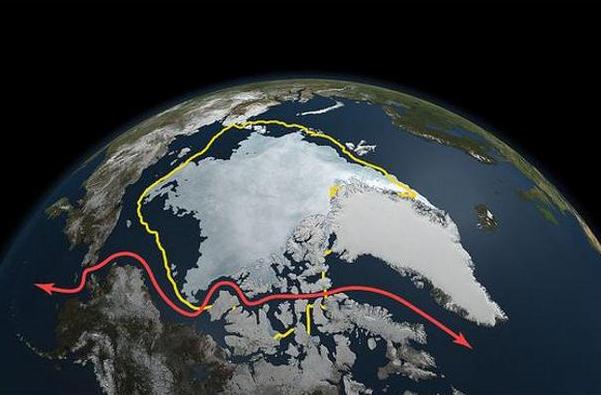
Arctic Voyage Details Awesome View Of Climate. Here's an excerpt of a terrific article in the
Des Moines Register: "
In 1994, he and a colleague tried to sail the Cloud Nine through the Northwest Passage from east to west. Only two boats and nine people tried to get through then, and the Cloud Nine had to turn back when the sailors found the passage iced over completely. In 2007, when a record loss of sea ice occurred, the Cloud Nine sailed through without incident, with Thoreson aboard. “We went 6,694 nautical miles and never touched one piece of ice,” Thoreson said. “That tells me something is changing, even in my 20 years of experience in the Arctic. We now are 7 billion humans gaming the system. We are forcing the cycle.” In 2009, aboard Ocean Watch, Thoreson turned his lens on Fiberglas recreational boats that were sailing the Northwest Passage, part of a group of 15 or 20 boats making the trek that summer. The sail on the 64-foot, steel sailboat Ocean Watch was the first continuous, west-to-east circumnavigation of the Americas, a path of 25,000 nautical miles that included 50 port calls in 13 countries. Thoreson said he is the first American sailor to make it through the Northwest Passage in both directions."
Cute Animal + Warming Climate = New Species (Of News). Bill Blakemore from
ABC News is doing some terrific enterprise reporting on climate change. Here's an excerpt from a recent story: "
The unprecedented and immense problems now brought on by manmade global warming are transformative in many ways. The world’s national intelligence and security agencies, finance leaders, insurance companies, and food markets are all rearranging plans as they adjust to accelerating climate disruptions. Less noticed, but no less telling of its effect on our feelings, is how the climate crisis has transformed the durability of some of our news segments. It has produced a new species of reports that paradoxically grow ever more urgent, more “newsworthy,” after we first publish them – as if they were swimming in some sort of journalistic Fountain of Youth."
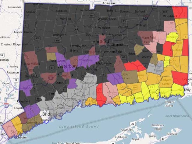
Businesses Can't Deny Bad Things Do Happen. Residents of Connecticut (and much of the northeast) have to be scratching their heads in wonder, after Irene, Lee, and now the biggest pre-Halloween snowstorm ever recorded. A fluke? Or signs of a more extreme climate to come? Here's a story about weather risk, courtesy of
hartfordbusiness.com: "
If you ask scientists and risk managers, you get this answer: “Our risks are not what they used to be.” Evidence-based research indicates that what we are experiencing is an emerging new class of disasters due to changes in our climate. As a result, many insurance companies are already updating their risk models. It was reported in a study conducted by Ceres, a consortium of public interest groups, that most insurance companies “believe that climate change will increase their losses.” What does this mean for business? The consequences of not being prepared for emergencies have never been greater. Yet, the denial or minimization of future emergencies is a big reason why businesses are not prepared. “It’s not going to happen here,” or “It’s not going to happen again” are common beliefs, yet are based on a false reality as evidence shows. One of the top reasons why businesses fail is that management and leadership are in denial about something critical. Emergencies do have the ability to end businesses. Just take a look at the businesses impacted by Hurricane Katrina years after the event." (photo credit above:
modernsurvivalblog.com).


No comments:
Post a Comment