.03" liquid precipitation predicted today (NAM model). That should translate into a dusting to .4"
snow, enough to possibly ice up a few roads, especially north/east of the metro area.
35-40 degree F. highs possible Christmas Eve and Christmas Day.
8th brown Christmas for the Twin Cities since 1967 (professor Mark Seeley, U. of Minnesota).
38-42 F. highs possible Monday.

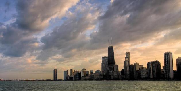
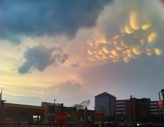
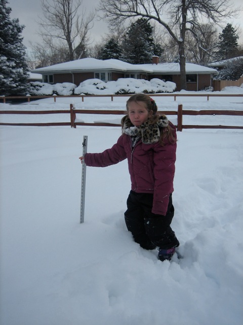
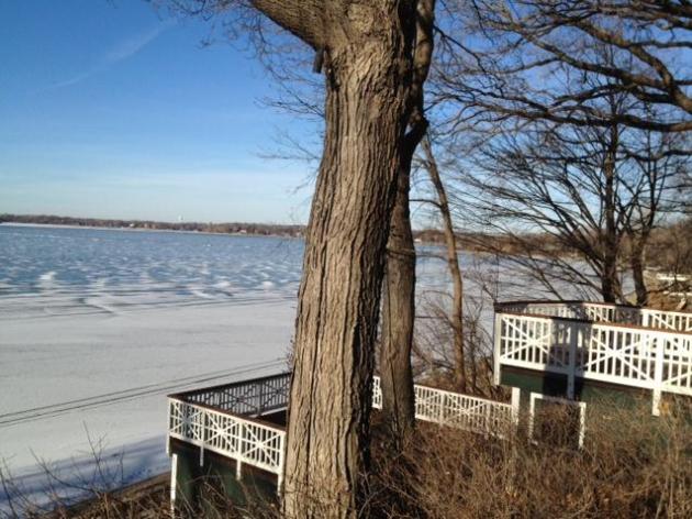
A Risk Of Brown. When I think brown I think of UPS, and maybe Cleveland...but not Minnesota in late December. The only real snow on the ground is over the Minnesota Arrowhead, a lousy 4-8", according to the latest DNR map. 2006 was the last brown Christmas, but I can't remember a December when we had so little snow on the ground as of December 23. More stark evidence of a deepening drought across the Gopher State.
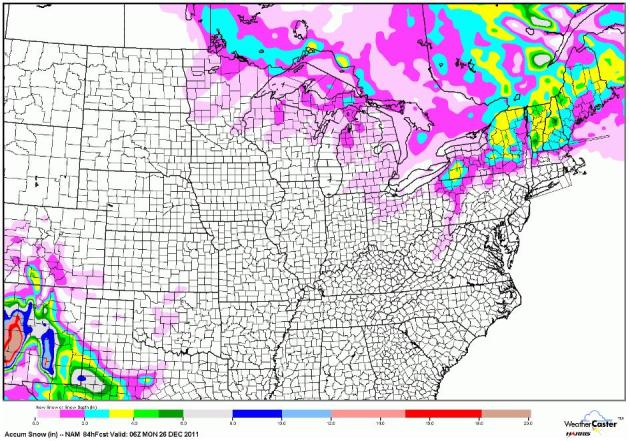
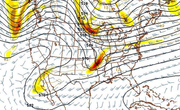
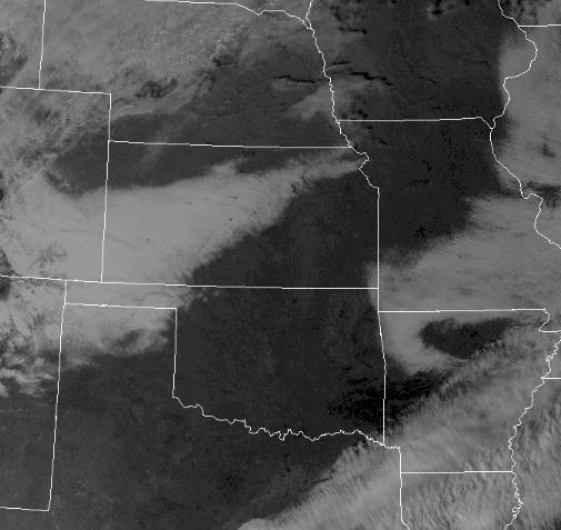
Additional Snow Between Now And Christmas. Parts of far northern Minnesota may still eek out a white Christmas, with 1" or more of snow on the ground. A few inches of snow is possible from the U.P. of Michigan into upstate New York and northern New England. That's pretty much it between now and Monday morning. NAM map above courtesy of NOAA and WeatherCaster.
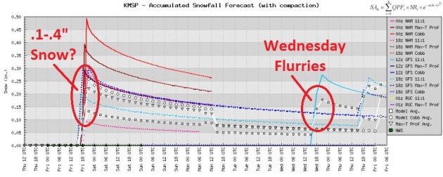
Dusting Of Snow Today? The models are hinting at a coating of snow from a fast-moving clipper today, maybe .1 to .4" snow - enough to coat some lawns and fields. Whatever does fall will probably melt Saturday afternoon with highs in the mid to upper 30s.
What Month Is This Again? The ECMWF (European) model may be overdoing the warming trend a bit - predicting 38-39 F. on Christmas Day and 44 on Monday. But a lack of snow means temperatures can climb 5-10 degrees higher than they would with snow on the ground, so I'm not discounting this altogether. Highs are forecast to be above freezing all next week, a slight chance of a light rain/snow mix on New Year's Eve. Don't get your hopes up too high.
An Early January Thaw? GFS numbers show a slow warming trend next week, highs consistently above freezing. These predicted temperatures are 10-15 degrees above average, nighttime lows more than 20 degrees warmer than normal.

Alaska declared a federal disaster area on Thursday making the state eligible for federal funding to supplement state and local recovery efforts in the area impacted by severe winter storms and flooding. As many as 4 separate storms packing hurricane-force wind gusts have affected Alaska since mid November. Photo courtesy of AP.
"This trend may produce a rare occurrence for many southern Minnesota observers, that of not having a single night of below zero F readings during the month of December!" - Dr. Mark Seeley, in his WeatherTalk blog referenced below.
"Our task is to win the debate on the merits, to employ, as best we can, honest and credible arguments in order to ascertain the reality of things. And if the science shows that Earth is warming and that humans have played a role in that, then we need to accept it, even if that puts us on the same side with some individuals we don’t find particularly appealing. What matters is where the truth lies, not the company we find ourselves in." - from an Op-Ed in Commentary Magazine below.
Many Ski Resorts Lack An Essential Ingredient. The New York Times has the cold, hard, snow-free facts: "WEST DOVER, Vt. — There were far too many skis on hand this week at High Altitude, a rental shop on the road to Mount Snow here, and Andrew Glover, the manager, was far too lonely. The problem was the weather. Week after maddening week of unusually balmy temperatures have made snowfall scant in New England, and, worse, wreaked havoc on snowmaking at ski resorts that like to have a healthy base of, at the least, manmade snow by Christmas." Photo courtes of the AP.
Not Ruling Out A Christmas Dusting. I'm not convinced we'll salvage a white Christmas (1" or more on the ground at KMSP), but a fast-moving Alberta Clipper may put down a coating of white early Sunday, a better chance of a carpet of snow north/east of the metro area. Talk about coming right down to the wire.
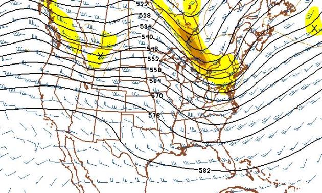
Dry/Mild New Year's Day. Weak ridging over the Upper Midwest should be good for 30s a week from Sunday- right now I don't see any major storms for January 1, with the possible exception of northern New England. Again, the flow is zonal, west to east, more typical of late October than the first day of January. Remarkable.
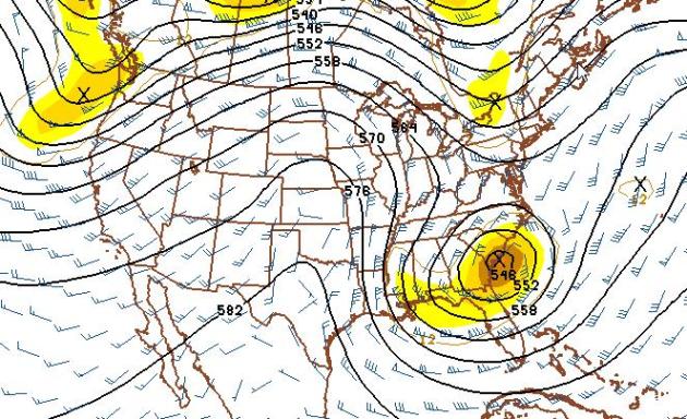
January 5 - 40s for Minnesota? The 570 line at 500 mb (18,000 feet) right over Minnesota...on January 5? I've never seen this in my 27 years here in Minnesota. If this verifies it could be good for mid 40s, 50 not out of the question. Talk about a dramatic January Thaw. The long-range GFS model is also hinting at a major storm for the southeastern USA, with a sharp cold frontal passage as far south as Florida. In fact it may not be that much warmer in Florida than it is in Iowa and southern Minnesota. What a strange pattern.
Here are candidates for the top five weather events of 2011 from the Minnesota Climatology Working Group.
#5 Extreme Cold of January 20-21
The coldest air mass to hit Minnesota in two years sideswiped the state on January 20-21, 2011. The coldest air temperature found on January 21 was -46 at International Falls. This was the coldest temperature at the "Icebox of the Nation" since -46 on January 6, 1968. The temperature also bottomed out at -46 at Babbitt as well. This was the coldest air to move over Minnesota since January 14, 2009 when Babbitt saw -48. This cold came in the middle of one of the snowier winters in recent years.
#4 Record-Setting Non-tornadic Winds in Kittson County: September 1
On September 1, severe thunderstorm winds were clocked at 121 mph at an automated station a mile west of Donaldson in Kittson County. Two large commercial grade steel bins were torn out from the local grain elevator and the significant tree damage in the area matched winds of that extreme range. 121 miles per hour is the strongest wind speed measured in Minnesota. While wind speeds of this magnitude, and higher have likely occurred in Minnesota in the past, there wasn’t any instrumentation that survived to record the wind speed. Due to the proliferation of automated weather stations in Minnesota, there is a greater chance that one of these gusts can be measured.
#3 Driest Meteorological Autumn in Twin Cities History
A scant 1.36 inches fell from September 1 to November 30 in the Twin Cities, the driest since modern records began in 1871. The dryness in the Twin Cities was a reflection of the large scale drought situation that intensified across Minnesota in the late summer and autumn. Soil moisture levels at the University of Minnesota Southern Research and Outreach Center in Waseca by mid November were the lowest seen in recent years.
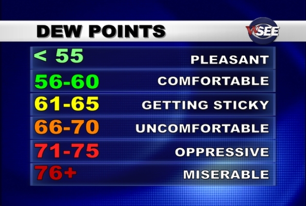
#2 Record Dew Point Temperatures: July 19, 2011 For the Twin Cities and Minnesota
On Tuesday, July 19, 2011 the dew point temperature reached 82 degrees at the Twin Cities, breaking the old record of 81 that was set on July 30, 1999. In addition, the highest dew point temperature recorded in Minnesota was set at the Moorhead Airport with 88 degrees, breaking the old record of 86 that was set at both Pipestone and St. James on July 23, 2005. The high dew point temperatures had some odd effects. When people wearing glasses walked outside from the indoor air conditioning, their eyeglasses instantly fogged up. Window air conditioners quickly sold out around the Twin Cities.

Minneapolis Tornado: Sunday, May 22, 2011. The Minneapolis tornado killed one person and injured 48. The hardest hit area was from Lowry Avenue and Logan Avenue in Minneapolis to 42nd and Lyndale Avenue. The tornado then crossed the Mississippi River and caused damage in Anoka County. This is the second tornado to hit Minneapolis in three years. There hasn’t been a tornado reported in Ramsey County since 1998.
Honorable Mention
Brown Christmas 2011
Similar to 2006 when most places south of Highway 2 from Grand Forks to Duluth had little or no snow on the ground. In 2011 the snow-free area looks to be even more extensive with northwestern Minnesota also most likely not having any snow on the ground on Christmas Day.
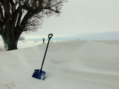
A Very White Christmas In The Mile High City. Thanks to Daisy Bailey for passing on this photo - she lives in Lakewood, a suburb of Denver, where a cool foot of snow fell. Must be nice, huh?
Snowfall Amounts In The Denver Area:
DENVER INTL AIRPORT 5.8 15.0 28.0
DENVER-STAPLETON 6.5 15.0 24.3
DENVER CITY PARK 4.0 13.5 26.8
EVERGREEN 21.0 38.9 56.5
NORTH LONGMONT 9.7 19.1 39.3
RALSTON RESERVOIR 13.0 20.5 33.0
WHEAT RIDGE 10.1 24.5 39.7
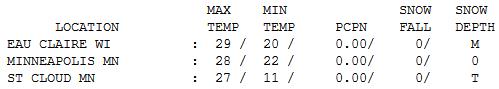

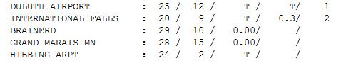
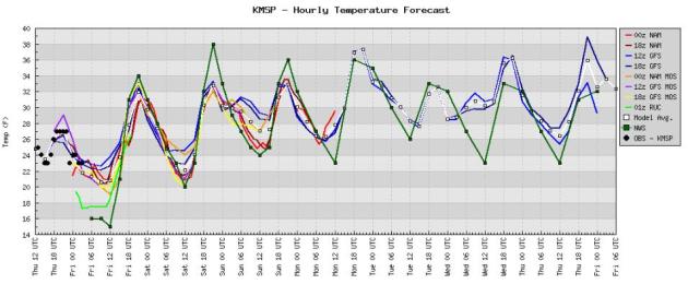
Thursday Numbers. Yesterday may have been the coolest day we'll see for the next week, maybe two. I know it sounds crazy, but I see a gradual warming trend next week, a string of 30s, 40 not out of the question. Thursday highs ranged from 20 at International Falls (2" snow on the ground), to 25 at Duluth (one whole inch reported), 27 at St. Cloud and 28 in the Twin Cities, a balmy 30 at Redwood Falls.
Paul's Conservation Minnesota Outlook for the Twin Cities and all of Minnesota:
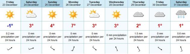
FRIDAY: More clouds than sun, flurries may dust a few roads, especially north/east of the metro area. Winds: SW 10-20. High: 36
FRIDAY NIGHT: Partly cloudy, seasonably cool. Low: 21
CHRISTMAS EVE: More sun, thawing out a bit. High: 37
SATURDAY NIGHT: Patchy clouds, tracking Santa on Doppler. Dusting of flurries late? Low: 24
CHRISTMAS DAY: Partly sunny, Wisconsin flakes taper. High: 35
MONDAY: Bright sun, feels like early November! Low: 24. High: 43
TUESDAY: Mix of clouds and sun, dry sky. Low: 22. High: 37
WEDNESDAY: More clouds, few flurries. Low: 23. High: 32
THURSDAY: More clouds than sun, dry roads. Low: 21. High: 34
Remembering 2011
Is the weather getting wilder or is it just our imagination? 2011 brought the most billion dollar weather disasters on record, and Minnesota had its fair share of eye-opening headlines. In fact, the Minnesota Climate Office just released their "Top 5 Weather Events of 2011" list. Coming in number 1: the May 22 Minneapolis tornado, the second tornado to hit the city in 3 years. Second place: the July 19 dew point of 82, an all-time record for the Twin Cities. The driest meteorological autumn on record came in at number 3; our predicted brown Christmas scored an honorable mention. Check it out on my blog. Never a dull moment.
NOAA's CPC, Climate Prediction Center, is backing (way) off an earlier prediction of colder and snowier for the northern tier states. La Nina, La Schmeena! It doesn't seem to matter that Pacific Ocean water is trending cooler than normal. A stupefyingly persistent west wind howling from Vancouver is keeping bitter air bottled up near the Arctic Circle; we should reach 30s (above zero) into the first week of January.
A feeble clipper whips up decorative flurries today (dusting or coating of snow can't be ruled out); a Christmas thaw may give way to November-like 40s by Monday. Remarkable.
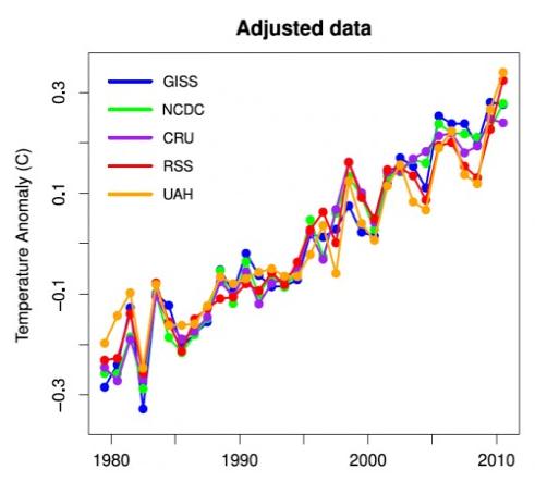


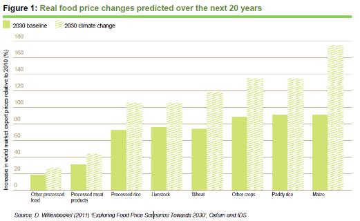
Foster and Rahmstorf (2011) have published a paper in Environmental Research Letters seeking to extract the human-caused global warming signal from the global surface temperature and lower troposphere temperature data. In order to accomplish this goal, the authors effectively filter out the effects of solar activity, the El Niño Southern Oscillation (ENSO), and volcanic activity. The result is shown in Figure 1 above.
From Planetsave (share this quote)

Top 5 Of 2011: #4. Who's Attacking Climate Scientists? The Institute For Southern Studies has the story: "But in 2011, Facing South's highest-profile story about climate-science shenanigans was our in-depth investigation into the forces behind a new type of attack on climate scientists: In October, we revealed the dirty-energy interests behind an effort to target those scientists using the Freedom of Information Act. Our story looked at the American Tradition Institute -- a free-market think tank that wants the public to believe human-caused global warming is a scientific fraud -- and its lawsuit against the University of Virginia seeking the release of emails and other documents from former professor Michael Mann (in photo), now at Penn State. One of the world's preeminent climatologists, Mann has become a target of the climate-denial movement because of his research documenting the recent spike in earth's temperatures."
Conservatives And Climate Change: Facts Need To Be Our Guiding Star. I couldn't agree more with an Op-Ed in Commentary Magazine. Here's an excerpt: "The second statement I want to focus on is this one: “Rather than the onus being on conservatives to bow to the dictates of warming science, it is the responsibility of those who wish to convince skeptics to make their case in a more accountable fashion.” To be clear: I’m not in favor of having conservatives “bow to the dictates of warming science.” But I am in favor of conservatives examining, in an independent and dispassionate manner, the best evidence we have on the matter of anthropogenic global warming (AGW). And the case for AGW has, in my estimation, been made. This doesn’t mean there aren’t some climate scientists who have exaggerated the threat or contorted the data. I said as much in my posts. But it’s simply not the case that this field of science is entirely corrupt or that the vast majority of climate scientists are dishonest and/or being intimidated to state conclusions with which they disagree."
"This year has seen a great many important climate stories. Obviously, the continued self-destructive failure of the nation and the world to reverse greenhouse gas emission trends always deserve to be the top story in some sense:
- Biggest Jump Ever in Global Warming Pollution in 2010, Chinese CO2 Emissions Now Exceed U.S.’s By 50%
- IEA’s Bombshell Warning: We’re Headed Toward 11°F Global Warming and “Delaying Action Is a False Economy”
And the energy story with the biggest climate implication was clearly Fukushima:
- Japan scraps plan for 14 new nuclear plants
- No nukes, No problem. Germany is proving a rapid transition to renewable energy is possible: “Within four decades, one of the world’s leading economies will be powered almost entirely by wind, solar, biomass, hydro, and geothermal power.”

No comments:
Post a Comment