19 days at or above freezing so far in December.
+ 7.1 F. December temperatures are running just over 7 degrees above average, according to the NWS.
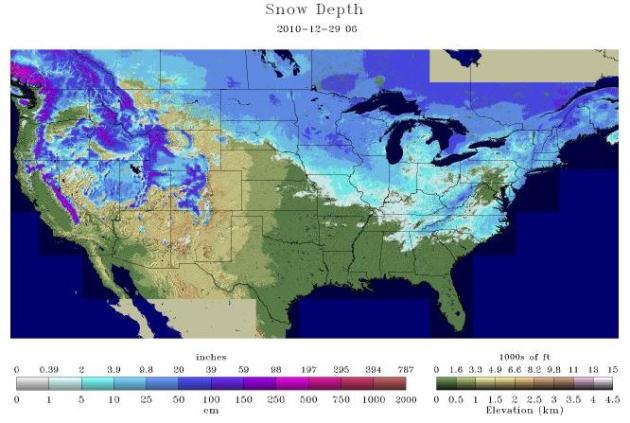
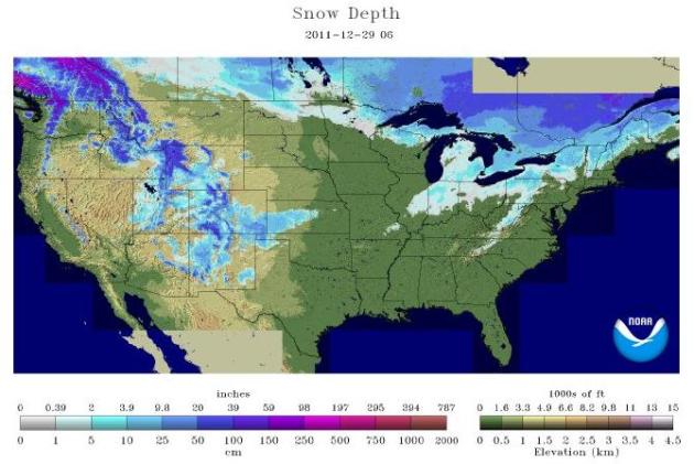
8.6" snow so far this winter season (5.6" of that fell in December).
43.2" snow fell as of December 29, last year.
3 minutes. As of tomorrow daylight will have increased by a whopping 3 minutes since December 21.
Early Morning Advisories. Both the Winter Weather Advisory and the Freezing Rain Advisory expire at 6 am this morning - the biggest concern is freezing rain/drizzle, rain freezing on contact with sub-freezing surfaces, mainly south/west of the Twin Cities. The metro area may pick up a coating to 1" of slushy snow today, mixed with a little freezing drizzle at times. With temperatures at or just above freezing I expect most roads to remain wet. Bridges and secondary roads, especially outside the metro area, may be icy.
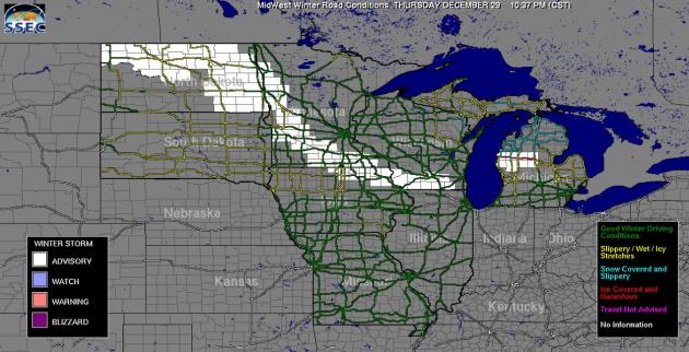
Road Conditions. The University of Wisconsin has a useful site displaying road conditions across the entire Upper Midwest. Yellow implies "slippery/wet/icy stretches". For the latest update click here.
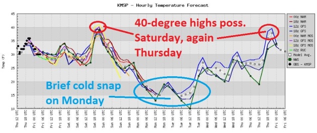
Big Swings. After peaking at or just above 40 New Year's Eve a vigorous cold front will knock highs into the teens Monday, but any (fresh) air will be brief. We start to warm up by the middle of next week; highs may reach the 40s again by Thursday of next week.
10 days above 50 so far this month in Kansas City, the most since 2006 when the city experienced 13 days above 50.
Cleveland still under 10″ of snow/yr. Since 1950 its happened 15 times! (source: Scott Sabol, Twitter).
YEAR PRECIP
1. 2008 50.86"
2. 2011 49.41" (through December 27)
3. 1983 49.35"
4. 1970 46.09"
5. 1954 45.92"
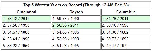
The year stands only 1.45" behind 2008. But given the forecast through Saturday it is highly likely that 2011 will remain as the second wettest year on record. Source: Chicago office of the National Weather Service.

Pacific Northwest Rainfall Amounts:
2.78" Skokomish, WA
2.06" Coos Bay, OR
2.04" Langlois, OR
New Ohio State Rainfall Record:
76.1" Cheviot (Hamilton County). Old record was 70.82", set in 1870 at Little Mountain, Ohio.
73.12" Cincinnati, Ohio: new yearly rainfall record (old record was 57.58" in 1990).
2.06" Coos Bay, OR
2.04" Langlois, OR
New Ohio State Rainfall Record:
76.1" Cheviot (Hamilton County). Old record was 70.82", set in 1870 at Little Mountain, Ohio.
73.12" Cincinnati, Ohio: new yearly rainfall record (old record was 57.58" in 1990).
Avalanche Warning For Wyoming. The Bridger- Teton National Forest Avalanche Center has issued an avalanche warning until midnight Friday. High winds and heavy snowfall have prompted this warning. Natural and man made avalanches are likely to occur. Source: National Weather Service.
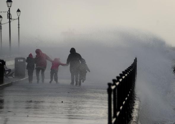
Photo credit: "High winds battered the promenade in Largs, with waves crashing over, while these two dogs were left looking a bit windswept by the weather. Photos: Robert Perry."
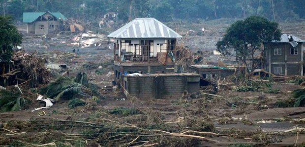
Sendong Was A Weak Storm, Ranked Among Most Destructive In PHL History. Here's an update from GMA News Online: "Tropical Storm Sendong was a bizarre weather creature — a "weak" storm by the standards of PAGASA yet it claimed more lives than any typhoon in more than a decade. Its destructiveness came from the rare and "very extreme" amount of rainfall dumped on northern Mindanao on Dec. 16. According to a new analysis of the storm by the scientific institution Manila Observatory, the 180 millimeters (mm) of rain that fell in Cagayan de Oro on that day far exceeded the previous record of 142mm in 1999. Rainfall has been measured in the Lumbia weather station in Cagayan de Oro since 1977. The same study by the Manila Observatory cited historical evidence that storms rarely make landfall in Mindanao. That fact has been used to explain why local officials and the public didn't show much of a response to warnings about Sendong's pending arrival. The Manila Observatory noted that in the last 15 years, only six tropical cyclones crossed Mindanao, and only one in 10 years in December." Photo credit here.
Top 5 Extreme International Weather Events Of 2011. The Washington Post's Capital Weather Gang has the story: "Earlier this week, we looked at the top five extreme weather events to impact the U.S. this year. Not confined to any particular borders, Mother Nature also brought extreme conditions to other parts of the world in 2011, including deadly storms, flooding and prolonged drought. Globally, extreme weather events were responsible for tens of thousands of deaths, not to mention billions of dollars in damages.
Related link: NASA scientist warns “climate dice” loaded for more extreme weather
Let’s take a look at the top 5 extreme weather events to occur outside the U.S. in 2011:
1. Drought in East Africa
By far the deadliest natural disaster of the year, a severe and prolonged drought in Somalia, Djibouti, Ethiopia and Kenya triggered a food crisis in July 2011."

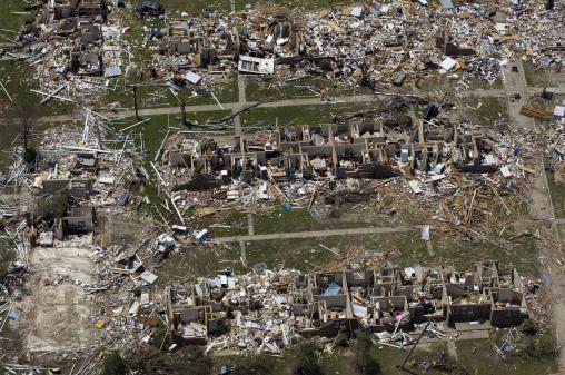
Top 10 Photo Galleries Of 2011: Hurricanes, Tornadoes, Maniacs And More. Masslive.com has the story: "2011 was a year made for photographs. Frankly, if we didn’t have the photographic evidence for some of these events, who would have believed that New England experienced a hurricane that caused widespread flooding, an unusually big autumn snowstorm and a tornado that ripped a 39 mile-long ‘Path of Fury’ through nine towns -- all within a span of a few months. Not surprisingly, The Republican's photographs of these natural disasters dominate the list of the Top 10 photo galleries of the year. Readers also found time to check out the entertaining side of the Pioneer Valley: from the annual Holyoke St. Patrick’s Parade to Southwick's Rugged Maniac Race, the photos show that Western Massachusetts knows how to play hard!" Photo courtesy of John Suchocki, The Republican.
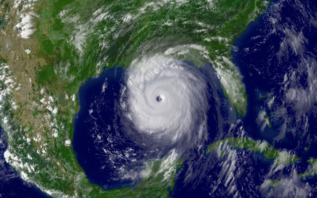
6 Years Later, Katrina Victims Fight FEMA Debts. SeattlePI.com has the story: "NEW ORLEANS (AP) — When the Federal Emergency Management Agency mailed out 83,000 debt notices this year to victims of Hurricane Katrina and other 2005 storms, one of the letters showed up in David Bellinger's mailbox. Bellinger, who is blind, needed a friend to read it and break the news that FEMA wants him to pay back more than $3,200 in federal aid he received after Katrina. "I nearly had a stroke," recalls the 63-year-old, who moved to Atlanta after the storm wrecked his New Orleans home. "I'm totally blind. I subsist entirely on a Social Security disability check. If I have to pay this money back, it would pretty much wipe out all the savings I have." Photo above courtesy of NOAA.
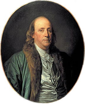
"Be always at war with your vices, at peace with your neighbors, and let each new year find you a better man." Benjamin Franklin. Photo above courtesy of Wikipedia.
"Many people look forward to the new year for a new start on old habits." - author unknown
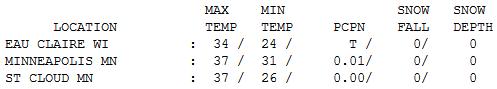

December Thaw - The Saga Continues. Is it me, or does this pattern more closely resemble early March than late December? You walk out the door, expecting to get knocked over by numbing air, and then quickly realize "this isn't so bad." A gray start gave way to a few PM peeks of sun Thursday, highs ranged from 34 at Eau Claire and Alexandria to 37 St. Cloud and the Twin Cities.
Paul's Conservation Minnesota Outlook for the Twin Cities and all of Minnesota:
TODAY: Periods of light snow and freezing drizzle; coating to 1" possible. Most roads should remain wet. Mostly cloudy. Winds: NW 7-12. High: 34
FRIDAY NIGHT: Partly to mostly cloudy. Low: 25
NEW YEAR'S EVE: Some mild sun, unseasonably mild. High: 41
SATURDAY NIGHT: Rain showers end as snow showers with about 1" accumulation expected. Turning gusty and colder. 19
NEW YEAR'S DAY: Windy and colder with more clouds than sun. Passing flakes. High: 24 (wind chill in the teens and single digits).
MONDAY: Coldest day in sight. Bright sun, less wind - a rare colder-than-average day. Low: 9. High: near 20
TUESDAY: Fading sun, light snow up north. Low: 8. High: 22
WEDNESDAY: Partly sunny, a bit milder. Low: 14. High: near 30
THURSDAY: Mild sun. Feels like March again. Low: 18. High: 43
Photo credit: icanhascheezburger.com.
Looks Like "Snow"
Snow /sno/ Noun. "Atmospheric water vapor frozen into ice crystals and falling in light white flakes or lying on the ground as a white layer." You remember snow right? This morning will be a subtle yet blunt reminder of where we're living. Brown ground in late December is an aberration, a fluke; not the natural order of things.
A slow-moving Alberta Clipper may drop a coating to 1" of slushy snow today, just enough to complicate the morning commute a bit (better chance of freezing rain/drizzle over southwest MN). This will be an almost March-like snow, temperatures near freezing - meaning mainly wet freeways, but potentially plowable amounts outside the metro.
Take a photo, because much of the snow will melt by tomorrow as the mercury passes 40 F; a New Year's Eve nearly 20 degrees warmer than average for much of Minnesota. Welcome to what will probably go down in the books as the 9th warmest December on record.
No subzero lows is unusual, but not unprecedented. According to meteorologist Dean DeHarpporte there have been 8 Decembers in the past 120 years where the mercury stayed above 0 all of December.
Expect a New Year's Day cold front; it will feel like January early next week. We thaw out midweek; more 40s by Thursday? Remarkable.

As Climate Change Worsens, Scientists Feel Increasing Pressure To Speak Out. InsideClimateNews.org has the story: "Factors contributing to climate change are moving faster than predicted and pushing us toward planetary conditions unlike any humans have ever known—this was one of the salient themes to emerge from this month's meeting of the American Geophysical Union, the world's largest gathering of earth and space scientists. Some scientists think we've already crossed that boundary and are, as Jonathan Foley, director of the University of Minnesota Institute on the Environment, said, "in a very different world than we have ever seen before."
Photo credit: "James Hansen of NASA, one of the most outspoken scientists when it comes to advocating for climate policies, participates in civil disobedience protests against the Keystone XL pipeline in Washington D.C./Credit: Rick Reinhard, flickr"

Global Warming: Wildlife Facing Extreme Weather Risks. The Summit County Citzens Voice (a consistently good source of climate news) has the story: "SUMMIT COUNTY — Extreme weather in 2011 may or may not be linked directly with global warming, but most climate scientists agree that droughts, flooding and other anomalous events are likely to become more frequent in coming decades. Along with potential impacts to human civiliation, the planet’s wildlife is also facing an unprecedented threat from natural disasters exacerbated by climate change — with no good way to identify vulnerable animal populations, according to a new paper published in Trends in Ecology and Evolution."
Photo credit: "Ice-dependent species like penguins are at risk from climate change. PHOTO BY BOB BERWYN."
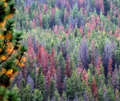
Photo credit: "Bark beetles have damaged pine trees in the Sawtooth Ridge area above the Methow Valley in the North Cascades. The beetles are whittling away at high-elevation trees once thought mostly safe from bugs. (Steve Ringman/Seattle Times/MCT)"
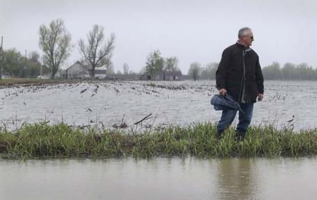
Quebec On The Verge Of Catastrophic Climate Change, Experts Say. The story from the montrealgazette.com: "Record floods, melting permafrost, shoreline erosion and intense winds caused havoc for thousands of Quebecers as 2011 proved to be yet another year of higher than normal temperatures. These higher temperatures add to the credibility of climate models that have predicted the march of global warming will accelerate the more greenhouse gases we pump into the atmosphere, scientists say. “It is striking that over the last 10 to 15 years we didn’t have a single season colder than normal,” said Alain Bourque, director of climate change impacts and adaptation at Quebec’s climate change research institute Ouranos. “That is a clear indication that Canada’s climate is heating up beyond any reasonable doubt.”
No comments:
Post a Comment