Tuesday, May 31, 2011

Summer Outlook (and why climate experts are using tougher language)

Paul's Conservation Minnesota Outlook for the Twin Cities and all of Minnesota:

TODAY: Sunny start (less wind). High clouds increase by late afternoon/evening. Winds: W 10-15. High : 73

WDNESDAY NIGHT: Partly cloudy - chance of T-storms late (a few may be severe over southwestern MN). Low: 61

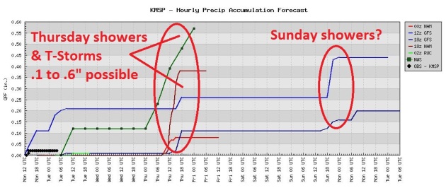
THURSDAY: Sticky, few strong/severe T-storms possible. High: 77

FRIDAY: Hot sun, get to the lake - fast! Low: 68. High: near 90 (!)

SATURDAY: Mix of clouds and sun, a bit cooler, but still pleasant. Low: 64. High: near 80

SUNDAY: Sunny start, stray PM T-shower? Low: 63. High: 79

MONDAY: Intervals of sun, still summerlike. Low: 66. High: 85

TUESDAY: Clouds increase, nighttime storms possible. Low: 65. High: 83


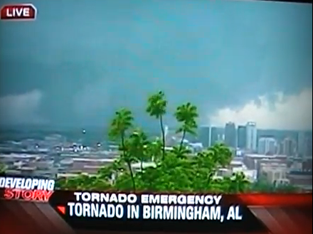
Amateur Tornado Chasing: Public Service or Menace?


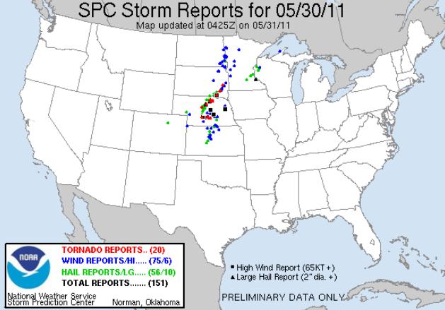
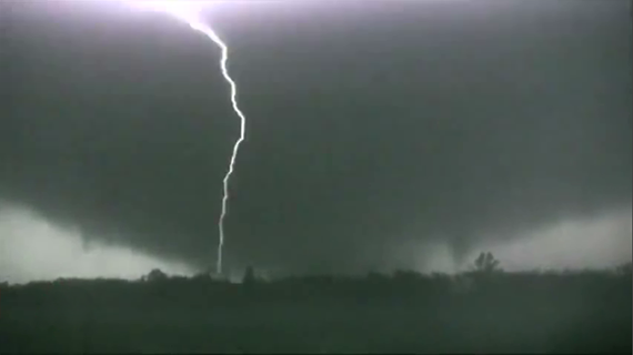
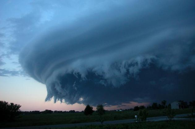
Severe Threat Tonight & Thursday for Minnesota.


First 90 On Friday?


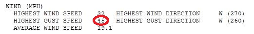
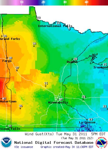
Wild Winds. The average wind speed on Tuesday was 19.1 mph at MSP, a peak wind of 45 mph. That's tropical storm force.


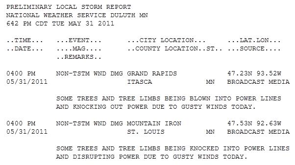
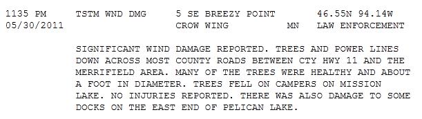
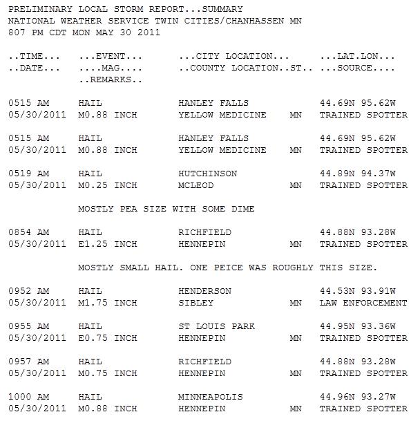
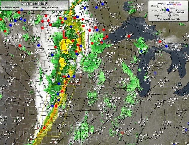
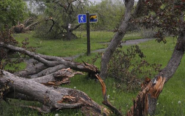
Wind Damage. High winds brought down trees and powerlines Sunday and Monday - the most extensive damage from near Breezy Point to Grand Rapids. A complete run-down of wind and hail-related damage from the NWS offices is here.


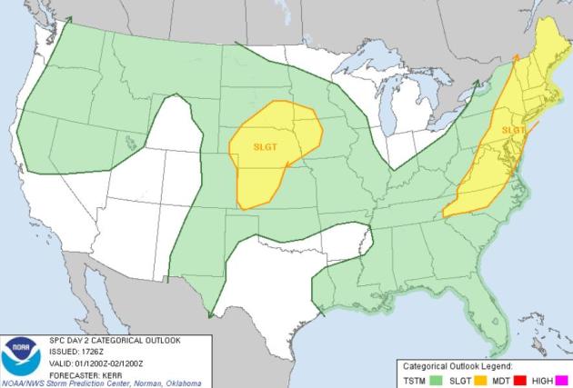
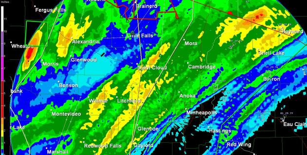
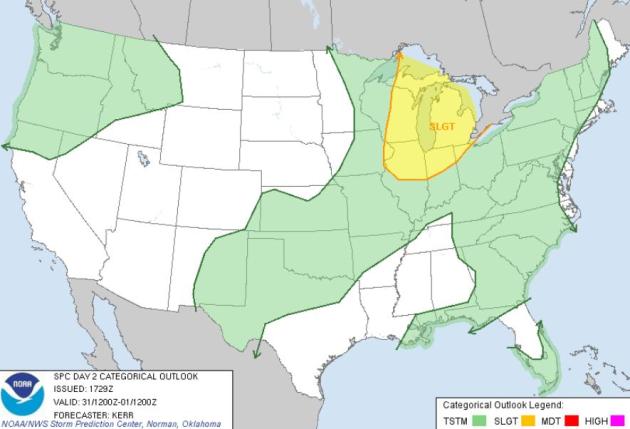
Another Severe Threat. The sun should be out much of today, clouds increasing during the PM hours, a good chance of T-storms late tonight into Thursday as another strong warm front surges north. A few storms over southwestern MN may exceed severe limits late tonight and early Thursday (58 mph wind gusts and/or 1" diameter hail). A few severe storms are possible in or near the Twin Cities Thursday afternoon into Thursday night as a 90-degree airmass approaches. Source: SPC.


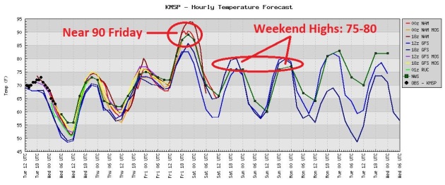
Friday Hot Front. Latest models show Friday highs in the mid 80s to near 90, followed by slight cooling over the weekend, when highs will range from the mid 70s (north) to the low 80s (south).


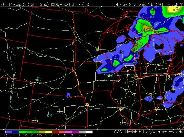
Saturday Preview. Models keep most of the state dry Saturday, with the exception of a few PM showers and possible T-storms over far southeastern counties. Highs should range from mid 70s (north) to low 80s south of the MSP metro. NAM model output valid 1 pm Saturday.


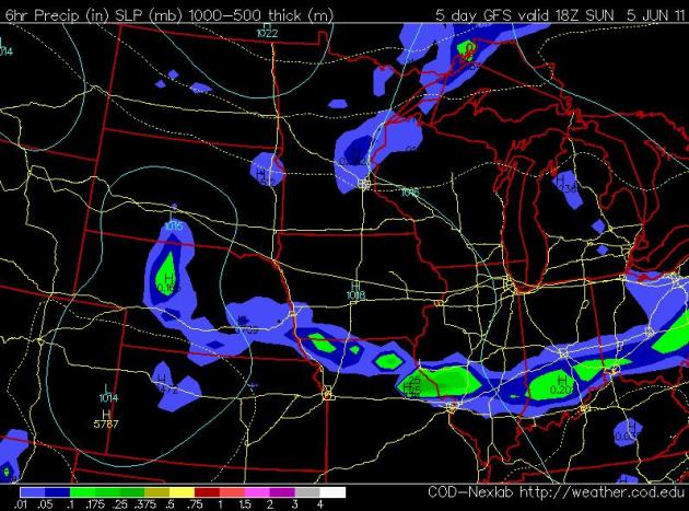
Stray PM T-Storm Sunday. Much of Sunday looks dry, but a weak disturbance in the upper atmosphere may fire off a few PM T-storms. Too early to try to get specific. Highs will be in the upper 70s to near 80. NAM map above valid 1 pm Sunday.

 
(Shakopee photo courtesy of kengillphotography.com).

BULLETIN - IMMEDIATE BROADCAST REQUESTED FLOOD WARNING NATIONAL WEATHER SERVICE TWIN CITIES/CHANHASSEN MN
...THE NATIONAL WEATHER SERVICE IN CHANHASSEN HAS ISSUED A FLOOD WARNING FOR THE FOLLOWING RIVERS IN MINNESOTA...MINNESOTA RIVER AT SHAKOPEE AFFECTING CARVER...HENNEPIN AND SCOTT COUNTIES
THIS RIVER FORECAST IS BASED ON OBSERVED PRECIPITATION OF A
QUARTER INCH UP TO A HALF INCH...OVER THE PAST 24 HOURS. ALSO
UPSTREAM AND DOWN STREAM GAGES, AND FORECAST PRECIPITATION
OVER THE NEXT 24 HOURS. DRIER WEATHER IS EXPECTED THE NEXT COUPLE
DAYS ACROSS THE MINNESOTA RIVER BASIN...FOLLOWED BY MORE HEAVY
RAINS LATE IN THE WEEK...THAT COULD CAUSE RIVER LEVELS TO RISE
EVEN HIGHER THAN CURRENTLY PREDICTED. THE NATIONAL WEATHER
SERVICE WILL MONITOR THIS DEVELOPING SITUATION AND ISSUE
FOLLOWUP STATEMENTS AS CONDITIONS OR FORECASTS CHANGE.

PRECAUTIONARY/PREPAREDNESS ACTIONS...
DO NOT DRIVE CARS THROUGH FLOODED AREAS.  TURN AROUND...DON'T DROWN.
STAY TUNED TO NOAA WEATHER RADIO OR YOUR LOCAL RADIO OR TV STATION
FOR THE LATEST INFORMATION CONCERNING THIS FLOOD EVENT.


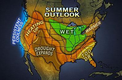
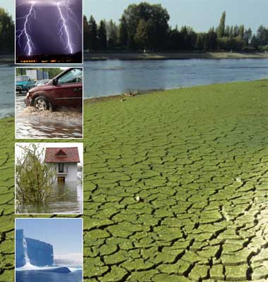
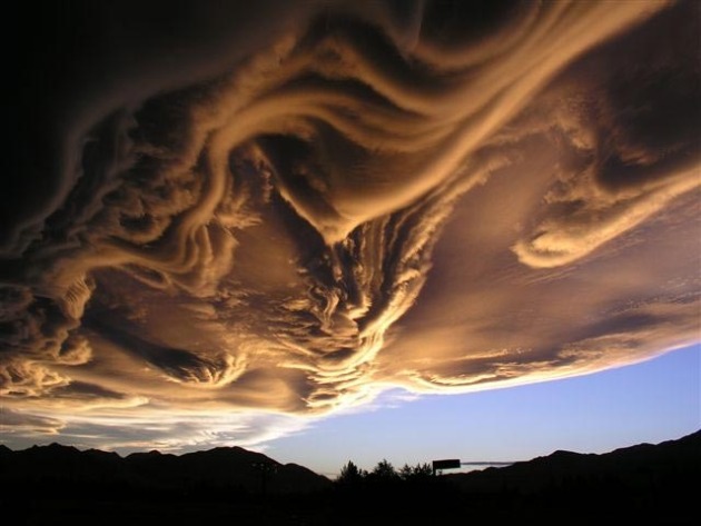
2011 Summer Outlook. Here is AccuWeather's summer outlook. I tend to agree (for the most part - a bias toward slightly cooler, wetter and stormier, with more severe storms than average, thanks to a jet stream blowing almost directly overhead for much of the next 60-90 days. More details: "The La Nina that has driven the extreme weather since winter is over, but the lingering effects mean no summer for the Great Lakes, drought conditions expanding out of the southern Plains, and flooding expanding into the Midwest from the Mississippi Valley. The end of the La Nina pattern will threaten to make this area a region "without a summer." Repeated intrusions of cool air from Canada along with showers and thunderstorms will keep temperatures below normal in many areas. Temperatures topping 90 F may be rare. The severe weather that has plagued the South this spring will shift northward. Frequent bouts of thunderstorms could mean numerous instances of flooding, hail and wind damage, even tornadoes. While we probably had the most extreme tornado activity of 2011 during April and May, the summer still has potential to bring a few moderate outbreaks of tornadoes. Flooding may be the biggest concern this summer, as already-soggy ground can handle only so much heavy rain."


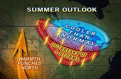
Stormier Than Average? I suspect AccuWeather has the right idea, with a forecast of more storms (severe and otherwise) than average this summer. Graphic courtesy of AccuWeather.


Storm Gashed Wirth Park. An update on the Minneapolis tornado from the Star Tribune: "The tornado that tore through north Minneapolis May 22 has left scars and open spaces that will remain for decades in the city's largest park. More than 300 trees were uprooted or badly damaged in 760-acre Theodore Wirth Park, which borders Golden Valley. They include giant cottonwoods, majestic elms and a heritage oak more than 300 years old. For Andrea Weber, a landscape architect with the Minneapolis Park and Recreation Board, the destruction was especially devastating. She manages several recreation projects around Wirth Lake that have been damaged or put on hold. Weber said crews had just finished building a 280-foot boardwalk that allowed people to walk from Wirth beach onto the lake and around the periphery of the swimming area. It was scheduled to open as soon as workers could pave a new parking area. Now the boardwalk is gone, reduced to fragments and blown across the lake. "It's trashed," said Weber. "It's disheartening to see things you just built get destroyed before people have even had a chance to use them."


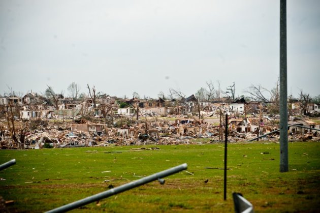
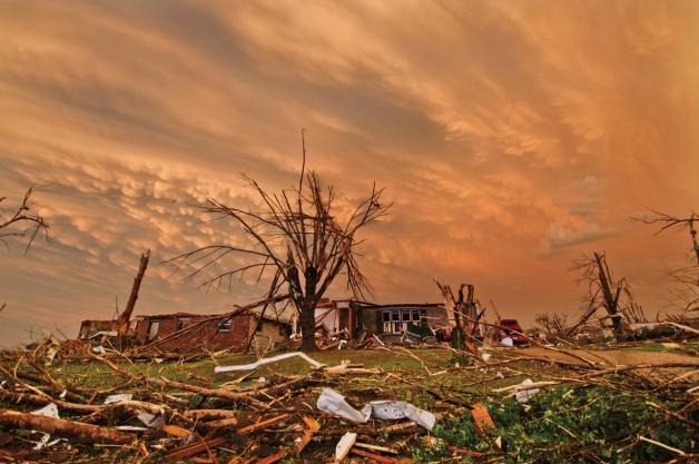
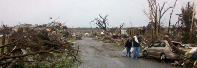
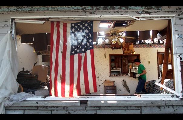
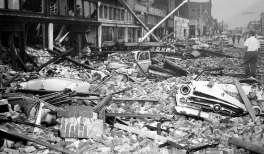
The Joplin Tornado: Six Miles Of Terror And Ruins. The register-herald.com has more details on the massive EF-5 tornado that swept through Joplin 9 days ago: "JOPLIN, Mo. — The eerie wail of warning sirens filled the warm, humid air at 5:20 p.m. Sunday, May 22, the day of Joplin High School’s graduation. Soon the sky faded from bright blue to green-gray, then to black, signaling a sense of imminent disaster. At 5:41 p.m. a monster tornado — described by a meterologist as “a fist coming out of the sky” — shattered the nervous calm that had enveloped Joplin, slowly crawling across the landscape at 20 mph with deadly force. For 20 minutes the twister chewed up one-third of this city of 50,000 like a giant dinosaur gone mad, obliterating homes, apartment buildings, businesses, churches, schools and one of the community’s two hospitals. The estimated toll: 8,000 structures, 300 businesses, 4,000 jobs, 1,150 injured and at least 142 lives lost. It was a cataclysmic day when the unthinkable happened. Those who survived remember what they were doing when the tornado struck. Here are their stories, mile-by-mile, along the path of destruction.


Are You Ready For More (Freak Storms?) Newsweek has the story: "Joplin, Mo., was prepared. The tornado warning system gave residents 24 minutes’ notice that a twister was bearing down on them. Doctors and nurses at St. John’s Regional Medical Center, who had practiced tornado drills for years, moved fast, getting patients away from windows, closing blinds, and activating emergency generators. And yet more than 130 people died in Joplin, including four people at St. John’s, where the tornado sucked up the roof and left the building in ruins, like much of the shattered city. Even those who deny the existence of global climate change are having trouble dismissing the evidence of the last year. In the U.S. alone, nearly 1,000 tornadoes have ripped across the heartland, killing more than 500 people and inflicting $9 billion in damage. The Midwest suffered the wettest April in 116 years, forcing the Mississippi to flood thousands of square miles, even as drought-plagued Texas suffered the driest month in a century. Worldwide, the litany of weather’s extremes has reached biblical proportions. The 2010 heat wave in Russia killed an estimated 15,000 people. Floods in Australia and Pakistan killed 2,000 and left large swaths of each country under water. A months-long drought in China has devastated millions of acres of farmland. And the temperature keeps rising: 2010 was the hottest year on earth since weather records began. From these and other extreme-weather events, one lesson is sinking in with terrifying certainty. The stable climate of the last 12,000 years is gone. Which means you haven’t seen anything yet. And we are not prepared."


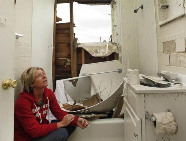
What Could Have Saved Joplin Lives? Basements. An estimated 10-20% of Americans have access to a basement or storm shelter - that's a big part of the challenge, especially if a large, violent (EF-4 or EF-5) tornado is moving in. Excavating a basement is cost-prohibitive across much of America, because of bedrock under the soil, or high water table levels. MSNBC has the story: "Like a lot of other Joplin homeowners, Herndon Snider rode out the May 22 tornado in a bathtub. Other popular places to take cover from the vicious tornado were closets and center hallways. Such is the price people pay for living in communities such as Joplin where basements are rare due to rocky, wet soil. About 87 percent of homes in Joplin have no basements, according to the Jasper County assessor's office. The vulnerability of residents to injury or death in tornadoes for lack of a basement has drawn attention to the need for more storm shelters for individuals or large groups of people. "I'll bet there will be a lot of them built here," Snider said. The EF-5 tornado has been rated the deadliest single twister in the United States since 1947. The official death toll was 146 as of Tuesday. Joplin Fire Chief Mitch Randles saw first-hand what a tornado can do. The twister destroyed his house, which has no basement. Nobody was home at the time. "My wife told me we are never going to own a home without a basement or storm shelter," Randles said. Digging basements in most of Joplin is impractical and cost-prohibitive because of a high water table and limestone just below the surface, said John Knapp, professor of geophysics at Missouri Southern State University in Joplin."


Environmental Dangers Lurking In Joplin Debris. KCCI-TV in Des Moines has the story: "Experts said environmental dangers could be lurking in the air, water and debris piles in Joplin, Mo., following last week's deadly tornado.Hazards range from liquid fuels and chemicals that may have leaked from ruptured containers to soot from smoky fires.Crews with the U.S. Environmental Protection Agency have been inspecting the devastated city. They say no major spills or other ecological crises have turned up, even though among the ruined structures are chemical suppliers, natural gas companies and paint manufacturers.Missouri officials have relaxed some environmental regulations to expedite the cleanup. The waivers allow limited burning of woody debris. Landfills can accept some types of waste that are normally off-limits.The tornado leveled much of the city and killed more than 130 people."


Elephant Helps With Tornado Clean-Up. Video News Feed and WFLA-AM radio report: "Elephants from the Picadilly Circus assist in the post-tornado cleanup in Joplin, Missouri, moving cars and other heavy debris."

Chiefs, Rams Lend Hand To Recovery Efforts In Joplin. Nice to see these guys stepping up, as reported at Sports Illustrated: "In 1994, when Matt Cassel was 11, his home was at the epicenter of the Northridge earthquake in California. Water from the inground swimming pool came crashing into the Cassel home, and a huge marble pillar pinned his father, Greg, beneath it. The family home was condemned. That's a heck of a thing for an 11-year-old to cope with. That was big. But last Thursday was bigger. Much bigger. Matt Cassel and his new teammate, wide receiver Jonathan Baldwin, drove two hours from Kansas City to Joplin, where a tornado the previous Sunday had torn a ruinous two-mile-by-six-mile path through what once was Americana. "It was the most shocking thing I've seen in my life, and I lived through being in the epicenter of a major earthquake,'' Cassel said over the weekend from his Kansas City home. "The devastation is like a nuclear bomb went off. Huge trees, 100 years old, ripped out by the roots. A car thrown up into the middle of a tree. It's one of those things you can't imagine unless you're there.'' Both NFL teams in Missouri pitched in last week. NFLPA czar De Smith swooped into Joplin with four Rams, including Sam Bradford and James Laurinaitis, on Thursday, and the club donated $25,000 to relief efforts. The Chiefs mobilized greater Kansas City, loading up six semis of water (187,490 bottles, by their count) and relief supplies, $35,000 from the club and $21,000 of private donations. Cassel, Baldwin and several other players went on the same day as the Rams, lifting spirits and clearing clogged yards and roads. "We may be in a work stoppage, but we're not in a life stoppage,'' Chiefs GM Scott Pioli said Friday. "This has given me a prime example of everything I was told this community was all about when I came here a couple of years ago.''


Compared With Other Disasters, Tornadoes Have Small Environmental Impact. Hurricanes impact a far larger area, but the build-up in wind is relatively gradual, over the span of 6-24 hours, going from 10 mph to 130 mph (for an extreme hurricane). With tornadoes the damage is far more localized, but winds reach 100-200 mph in a matter of SECONDS, resulting in swatchs of nearly total devastation, as reported by the Washington Post: "The 2011 tornado season has been particularly intense, killing more than 450 people and destroying untold millions of dollars worth of property. The tornado that ripped through Joplin, Mo., on May 22 killed at least 126 people and left a six-mile wide swath of destruction. But are tornadoes also environmental disasters? Not really. Tornadoes showcase nature’s raw power; but in the grand scheme of environmental threats — global warming, say, or agricultural runoff and algae blooms — they barely register. Consider their size. The average tornado is a mere 200 feet to 500 feet in diameter, and runs its course in just 1,500 feet. The biggest storms can leave tracks a mile wide and travel more than 30 miles on the ground. (There’s rarely noticeable damage more than a mile outside a tornado’s direct path.) Compare that to hurricanes, which average 300 miles across, for a total area of more than 70,000 square miles directly hit at a given moment. America’s largest forest fires have incinerated more than 4,000 square miles of land. The 2011 tsunami flooded 181 square miles in Japan. Earthquakes have damaged buildings across 50,000 square miles. Tornadoes are also relative weaklings. A tornado usually unleashes around 10,000 kilowatt-hours of energy — equivalent to nine tons of TNT. A hurricane weighs in around 10 billion kilowatt-hours. A magnitude 9 earthquake releases more than 550 billion kilowatt-hours of energy — the equivalent of 475 million tons of TNT or 25,000 nuclear bombs."


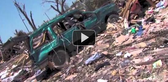
Tornado Survivor Captures Audio Of Walmart Destruction. Freight train? More like an angry fist from the sky punching the ground for 6 miles, a frightful wail of debris caught up in a shrieking, 200 mph blender. Ozarksfirst.com has the story:

"(Joplin, MO) -- A woman who survived the Joplin tornado says she's having a hard time getting the experience out of her mind. 

Rosie Peterson was in the Walmart store on South Rangeline Road with her husband and two daughters, ages 2 and 4. She said at first she thought the warning to take cover was a joke until a store employee began yelling, insisting everyone run to the back. Rosie and her husband did run, crouching by a display of DVDs and covering their daughters with a towel. She says when the worst of the storm passed, they still had strong hail and fierce lightning. When she saw the debris, she hit record on her cell phone. At that moment her survival instinct kicked in, and she tossed the phone in her purse, not realizing it was still recording the sounds of shock and disbelief as people tried to crawl through the wreckage to get to safety."


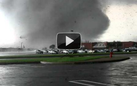
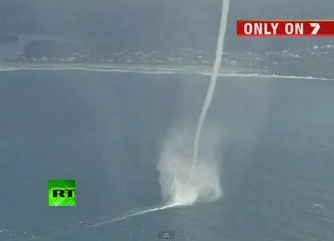
Our Tornado Voyeurism Problem. Andrew Freedman from the Capital Weather Gang has an intriguing post about the problem with tornadoes - and amateur tornado chasers (who are taking video when they should be heading for the basement). But as long as local TV stations and The Weather Channel keep playing (and paying) these video clips, people will continue to take huge risks: "I find these, and many other recent tornado videos, highly disturbing. Now I don’t have any disdain for storm chasing, quite the opposite, in fact. I’ve tagged along on two major storm research projects, most recently two years ago when I wrote a series of stories for this blog and saw my first tornado – from a safe distance. But both times I was embedded with scientists who were conducting research aimed at improving tornado forecasts. The tornado outbreaks during the past two months have propelled another breed of storm chaser - the idiotic amateur - into the limelight, raising many questions and concerns in the process. While lives are being lost, many of the videos show amateur chasers cheering the unprecedented weather, too caught up in the thrill of witnessing Mother Nature at her rarest (and deadliest) to comprehend the decidedly grim reality of what is taking place. On Sunday night, the National Geographic Channel aired a hastily put together documentary on the record tornadoes that occurred during April, “Tornado Swarm 2011.” The documentary featured many of the viral videos, strung together with narration by actor Campbell Scott. Although this surely was not the producers’ intent, one thing became glaringly obvious by watching video after video of people recklessly ignoring tornado warnings and rushing to view tornadoes up close, while screaming phrases like “This is awesome!” and “I’ll never see anything like this again!” - this country has a growing tornado voyeurism problem, and it’s one which may lead many to learn the wrong lessons from the recent deadly scourge of twisters. Call it the “YouTube Effect.” While they are sure to frighten some into taking more tornado precautions next time, these videos will very likely breed more amateur chasers who will run to the car when they hear tornado sirens, rather than heading for the basement."


Tornado Chasing: On A Downward Spiral Or Providing Public Value? The Capital Weather Gang poses an important question in the Washington Post. One of these days (amateur) tornado chasers and thrill seekers will be killed by a tornado, or trigger a horrific traffic accident. There are just too many people chasing (for sport) vs. trying to collect data critial for scientists to dissect after the fact: "Tornado chasing, largely limited to a small cadre of research scientists, photographers, and thrill seekers in the 1970s into the early 1980s, has transformed into a large and growing industry. Everyone wants to catch a glimpse of the action and these swirling vortices are swarming the TV networks and cyberspace - from reality TV to documentaries to movies to You Tube videos. They’ve even spawned a cottage tourism trade where you can fly to the Midwest and ride along with “expert” chasers. Earlier today, Andrew Freedman wrote about “Our Tornado Voyeurism Problem” - i.e. our obsession with viewing these violent storms, potentially putting ourselves and even others in harms way. Andrew featured some of the scathing commentary about the recent direction of tornado chasing from research meteorologist and pioneering tornado chaser Charles Doswell. But there is another point of view on proliferation of storm chasers...A couple weeks ago, I caught up with WeatherData CEO Mike Smith and author of “Warnings: The true story of how science tamed the weather”. For all of the criticism leveled at the flourishing chasing industry, Smith hasn’t soured on it like Doswell. “I believe it is a significant net benefit to society in general and the Great Plains in particular,” he said. “The storm chasing shows and, especially, the storm chase tour companies, I think ... give people an appreciation for the power and majesty of our atmosphere.


Despite Advances, Tornado Forecasts Show Limits. The average lead time warning for tornadoes has risen from 6 minutes in the 1970s to closer to 13 minutes today, nationwide. A tornado warning was issued roughly 25-30 minutes before the EF-5 tornado decimated much of Joplin, Missouri. An article in the New York Times highlights the limits of tornado prediction: "That tornado, in Arcadia, Neb., on June 7, helped for six decades to make 1953 the deadliest year for tornadoes since the National Weather Service and its predecessor, the Weather Bureau, began keeping records. That record of 519 fatalities has been eclipsed, with more than 520 recorded so far this year. Neither year, however, has had anything remotely approaching the 1925 Tri-State tornado, the deadliest single tornado in United States history, which killed 695 people by unofficial count. Tornado forecasting and the technology that accompanies it have improved greatly over the years, researchers say. Thanks to heightened reporting and awareness, better building practices and inventions like the radio and Doppler radar, tornado fatalities have declined steadily for nearly a century. But the disasters of 2011 underline a lingering reality: Many of the circumstances that were beyond science in 1953 are still beyond science today One factor is that, for unknown reasons, 2011 has had many more tornadoes than other recent years. Another is what the historian Thomas Grazulis describes with a single word: coincidence.


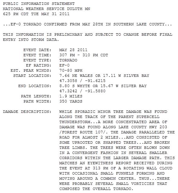
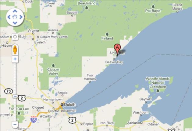
North Shore Tornado? The Duluth office of the NWS confirms a weak, EF-0 tornado on May 28 near Silber Bay. Winds may have reached 80 mph, a damage swath of nearly 2 miles of uprooted and snapped trees. Lake county may be Minnesota's safest counties, in terms of tornado risk - consistently cool winds blowing off Lake Superior are a deterent to supercell formation - making tornadoes between Duluth and Grand Marais very, very rare. That makes the May 28 tornado all that more unusual.


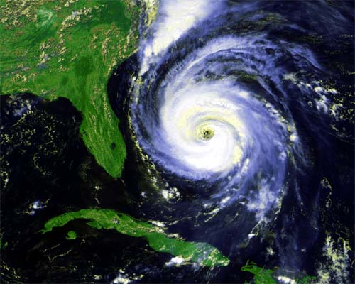
Our Take: On Hurricane Season. An update from the Orlando Sentinel on one of the few weather phenomenon we don't have to worry about here in Minnesota: "Images from recent deadly tornadoes in the Midwest are truly heartbreaking — but they should serve as a timely reminder for Floridians. The people in Missouri and Oklahoma and elsewhere didn't get a lot of warning before the killer tornadoes came roaring through. People have no time to get their homes properly protected and little time to be sure all family members are in a safe place. Not time to really do anything except hope you are not in the twister's path. A horrible tragedy, for way too many families. And a reminder that with the opening of hurricane season just ahead, we have the good fortune of time to properly prepare for what could happen. To an extent, we actually have months to prepare, since the peak of hurricane season isn't normally until the middle of August. If a storm heads our way, there are still usually days to prepare, particularly with the excellent forecasting accuracy for location and strength that we've seen in recent years."


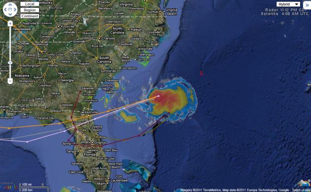
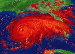
Tropical Storm Potential. Today marks the official kick-off of hurricane season, and right on cue, an area of disturbed weather is showing up off the southeast USA coast. Click here to see the latest satellite loop and forecast track from the Weather Underground.

Storm Phone Apps Rise To Popularity. USA Today has a timely review of some of the best storm apps out there. My favorite Doppler radar app remains "Radarscope". The best app I've found yet for getting real-time warnings is "My-Cast Weather Radar". Full disclosure: the My-Cast app is the brainchild of my previous company, Digital Cyclone, based in Eden Prairie. I've reviewed all the weather apps, and if you want timely warnings (for any location, including your current GPS location, as well as lightning alerts for cloud to ground strikes nearby) you can't do any better than My-Cast Weather Radar, in my humble (subjective) opinion. There's a one-time charge of $10, but it's worth every penny. No, I don't get a commission. Here are some other options highlighted in the article: "As images of destruction from recent tornadoes dominate TV news, weather apps for smartphones are in high demand. There's been a "definite change" in how consumers choose to receive severe-weather information, including alerts and forecasts, The Weather Channel's Melissa Medori says. Now that a ferocious tornado season is fading into the start of hurricane season, "we have definitely seen an increase in both app downloads and alert sign-ups," she says. Sign-ups have "steadily increased over the last couple years as more people become more reliant on their phones, and we also see spikes during severe weather events," such as the recent tornadoes in northern Alabama and in Joplin, Mo., says David Blumenthal of The Weather Channel. The Weather Channel's weather app for the iPhone has seen as many as 47,000 downloads a day, especially after the latest barrage of tornadoes. Most storm apps are based on data sent out by the National Weather Service, which the agency is happy to share.

117 Days/Row Without A Drop Of Rain. El Paso, Texas is in the midst of an exceptional drought - which may finally end today. Graphic courtesy of the National Weather Service.


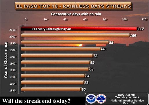
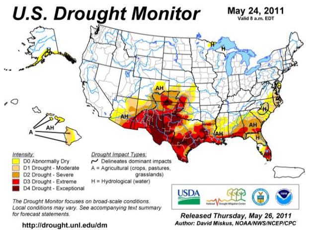
Expanding Drought. An "exceptional" drought is underway now across much of the Gulf coast - spreading westward into New Mexico, Colorado and Arizona. More from NOAA's Drought Monitor here.


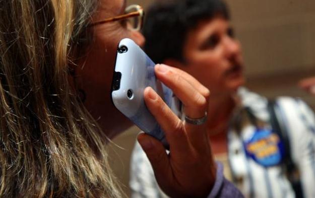
Experts Say Cell Phones Are Possibly Carcinogenic To Humans, Classify In Same Category As DDT. Great, just what I wanted to hear. Let me put my cell phone down and read this carefully. The Star Tribune has the details: "LONDON - A respected international panel of experts says cellphones are possible cancer-causing agents, putting them in the same category as the pesticide DDT, gasoline engine exhaust and coffee. The classification was issued Tuesday in Lyon, France, by the International Agency for Research on Cancer after a review of dozens of published studies. The agency is an arm of the World Health Organization and its assessment now goes to WHO and national health agencies for possible guidance on cellphone use. Classifying agents as "possibly carcinogenic" doesn't mean they automatically cause cancer and some experts said the ruling shouldn't change people's cellphone habits. "Anything is a possible carcinogen," said Donald Berry, a professor of biostatistics at the M.D. Anderson Cancer Center at the University of Texas. He was not linked to the WHO cancer group. "This is not something I worry about and it will not in any way change how I use my cellphone," he said — from his cellphone. After a week-long meeting, the expert panel said there was limited evidence cellphone use was linked to two types of brain tumors and inadequate evidence to draw conclusions for other cancers.


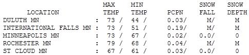
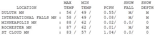
Blustery Tuesday. A tight pressure gradient whipped up 50 mph+ wind gusts across Minnesota yesterday. Highs ranged from 61 at Alexandria (1.41" rain) to 67 at St. Cloud, 73 in the Twin Cities (where only .02" rain fell).


Weather Slang

Partly cloudy means the same thing as partly sunny, right? Nope. A forecast of partly sunny implies more clouds than sun; while partly cloudy implies the sun will be out most of the day. Confusing? You bet. Probability of precipitation is another pet peeve. A 30% probability of showers doesn't mean it will rain 30% of the time, or 30% of us will get wet. It means that, on 3 out of 10 days with similar conditions, one location will pick up .01" rain or more. Say what? Just communicating the weather, choosing the right descriptive words, can be challenging.

Get ready for a big serving of severe-clear today, enough lukewarm sun for mid 70s. Expect a better hair day, winds under 15 mph. Soak up the blue sky, because the approach of a hot front will ignite more T-storms Thursday; a tiny percentage may turn severe. Friday will feel like July: 80s likely, with an outside shot at 90 from the MSP metro on south. A west/northwest breeze cools us off a few degrees Saturday, but expect a lake-worth day with highs in the 70s (north) to low 80s (south). A stray T-shower may sprout Sunday, but much of the weekend will be dry; suitable for shorts & T-shirts. No frost. No tornadoes. Whew..


Climate Truthers: Why Global Warming Deniers Are Conspiracy Theorists, Not Rational Skeptics. Stubborn skepticism in the face of overwhelming science is not a virtue - it's the celebration of ignorance, and let's call it what it is - denial. Sahil Kapur explains in Huffington Post: "The United States is experiencing a golden era of conspiracy theories. From the 9/11 Truthers to the Obama Birthers to the Trig Birthers and, most recently, the bin Laden Deathers, alternate theories of reality are alive and thriving on the American fringes, perhaps more so than ever in the age of digital media. One group of conspiracy theorists, however, has escaped the label -- and has even succeeded in bringing its theory into the mainstream. These are the people who deny that human activity is contributing to climate change, despite enormous evidence to the contrary -- call them the Climate Truthers, for lack of a better term. First the facts: the American and international scientific community overwhelmingly agree that carbon dioxide emissions are triggering a slate of harmful effects on the planet. "Climate change is occurring, is very likely caused primarily by the emission of greenhouse gases from human activities, and poses significant risks for a range of human and natural systems," declares a recent report by the U.S. National Academy of Sciences. The fact that a small percentage of scientists disagree -- which is also the case with, say, evolution -- doesn't mean the issue isn't settled. Yet unlike their counterparts, Climate Truthers aren't merely an irrelevant group of rabble-rousers -- on the contrary, the scientific consensus is denied by the leaders of one of America's two great political parties, as well as the majority of its ideological base. Speaker John Boehner, the most powerful Republican in the country, considers the notion that carbon emissions are harming the planet "comical." In recent years, this viewpoint has become something of a GOP litmus test, and today it's difficult to find Republicans who accept the scientific consensus."

Why Climate Experts Are Using Tougher Language. My friend and former WCCO-TV anchor/reporter Don Shelby has the story at minnpost.com: "A thermal scientist, a professor of meteorology, a certified genius on the planet's water and a journalist walk into a bar. The set up cries for a punch line. The reporter should end up the butt of the joke — unless the reporter keeps his mouth shut. Which I did. It was a bar at 15th and U Street in Washington, D.C. The four of us had gathered after each of us, variously, had attended sessions at the American Association for the Advancement of Science, the Union of Concerned Scientists and the World Bank. Three of the four at the table were among the leading thinkers in America on global warming. There was Professor Scott Mandia, of SUNY's Suffolk College, Professor John Abraham at the University of St. Thomas, Peter Gleick, the founder of the Pacific Institute and a MacArthur "genius grant" recipient. And, the guy with his mouth agape was me. I kept thinking, "I should have paid more attention in class." The three represented a small portion of the global-warming science community which had gathered to talk about why the message of human-induced global warming and its consequences was being overwhelmed by politics, and what scientists could do to make their findings clearer to the general public."

Climate Evidence Is In, It Is Time To Act As One. From the ABC Network in Australia: "The science of climate change has been subjected to intense scrutiny and has come through with its credibility intact. The findings continue to be sobering. Unfortunately, new data and analysis generally are confirming the likelihood that outcomes will be near the midpoints or closer to the bad end of what had earlier been identified as the range of possibilities for human-induced climate change. Global average temperatures have continued to track a warming trend. The year 2010 ranked with 2005 and 1998 as the warmest on record, with global average temperatures 0.53°C above the 1961–90 mean. For Australia, 2009 was the second-warmest year on record and the decade ending in 2010 has easily been Australia’s warmest since record keeping began. I noted in the 2008 Review the curious Australian tendency for dissenters from the mainstream science to assert that there is no upward trend in temperatures, or that if there had been a warming trend it has ceased or moved into reverse. Such assertions were prominent in some newspapers and blogs, but also appeared in serious policy discussions. The assertions were curious because the question of whether the earth is warming or not is amenable to statistical analysis....

...Progress has also been made on ruling out other possible causes of warming, such as changes in the amount of solar radiation reaching the earth. Scientists have identified ‘fingerprints’ of warming that confirm human influence. A primary example is the pattern of warming in the layers of the atmosphere. Under increased greenhouse gas scenarios, climate models predict that the lowest layer of the atmosphere (the troposphere) should warm, while the next layer up (the stratosphere) should cool. This has been confirmed by recent observation. If increased output from the sun were the cause, both layers could be expected to warm."
Limiting Global Temperature Rise To 2 C Now Looks Impossible. An update from gizmag.com: "Last year at the UN climate change talks in Cancun, it was agreed that cutting emissions sufficiently to limit the world's temperature increase to 2°C would require a far‑reaching transformation of the global energy system. To limit the world's temperature increase to 2°C, it was agreed that the long-term concentration of greenhouse gases in the atmosphere would need to be limited to around 450 parts per million of carbon-dioxide (CO2). Sadly, the International Energy Agency has just released figures indicating that energy-related CO2 emissions in 2010 were the highest ever, reaching 30.6 Gigatonnes (Gt). This means that to achieve the 2020 target, where emissions must not be greater than 32 Gt, emissions will need to rise less over the next ten years in total than they did between 2009 and 2010. "Our latest estimates are another wake-up call," said Dr Fatih Birol, Chief Economist at the IEA who oversees the annual World Energy Outlook, the Agency's flagship publication. "The world has edged incredibly close to the level of emissions that should not be reached until 2020 if the 2ºC target is to be attained. Given the shrinking room for manœuvre in 2020, unless bold and decisive decisions are made very soon, it will be extremely challenging to succeed in achieving this global goal agreed in Cancun." The IEA estimates that 40% of global emissions came from OECD countries in 2010, but OECD countries only account for 25% of emissions growth compared to 2009. Non-OECD countries - led by China and India - saw much stronger increases in emissions as their economic growth accelerated."


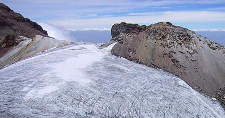
Melting Ice Has Its Downside For Canada. The article from marketwatch.com: "PORT TOWNSEND, Wash. (MarketWatch) — The famed “Ice Road Truckers” might become the Muddy Road Muckers if a new climate-prediction study that looks at the future of Canada’s melting permafrost is right. And forget the Northwest Passage, at least for now. But new far-north shipping routes opening up might well take up the slack. We’ve heard a lot the past couple of years about how climate change/global warming might open up northern Canada to farming and increased shipping. Not much about the downside. A trio of geographers at UCLA have released a study published in the journal “Nature Climate Change” saying that in the next 50 years, many of those ice roads you may have seen on the popular History Channel series will be impassable as the permafrost melts (one memorable episode featured a driver apparently risking his life to haul a truckload of salty snacks over frozen lakes to oil drillers). Global warming over the next 40 years “will cut through Arctic transportation networks like a double-edged sword, limiting access in certain areas and vastly increasing it in others,” the UCLA study predicts. “As sea ice continues to melt, accessibility by sea will increase, but the viability of an important network of roads that depend on freezing temperatures is threatened by a warming climate,” said the UCLA researchers. Read the UCLA study on the impact of global warming on Canada’s transportation.  If these scientific predictions hold true, it could have major implications, not just to remote villages that will become unreachable except by air, but also to industry. The study says implications could be “profoundly negative” for mining, energy and timber operations that now depend on winter ice roads."


Discouraging News. In a recent national study by the Yale Project on Climate Change Communication researchers investigated American teen middle and high school students knowledge of how the climate system works, and the causes, impacts, and solutions to global warming.   Using a straight grading scale 54 percent of teens received a failing grade compared to 46 percent of adults.
Broken up into three parts, Understanding of Climate ChangeKnowledge Gaps, and Common Misconceptions, a wide array of information was discovered.
  • 54% of teens say that global warming is happening, compared to 63% of adults.
  • 57% of teens understand that global warming is caused mostly by human activities compared to 50% of adults.
  • 17% of teens have heard of coral bleaching.
  • 35% of teens believe that the hole in the ozone layer is a large contributor to global warming.
“American teens recognize their limited understanding of the issue.  Fewer than 1 in 5 say they are “very well informed” about how the climate system works or the different causes, consequences or potential solutions to global warming, and only 27 percent say they have learned “a lot” about global warming in school. Importantly, 70 percent of teens say they would like to know more about global warming.“ (source: Scott Mandia).

Climate Change Linked To Social Collapses In Greenland Since 800 BC. Scientific American has the fascinating story "The Norse came to a new land around the end of the first millennium, borne on the backs of their Viking long ships and lured away from Iceland by the promise of Erik the Red's Greenland. The land was indeed green when they landed—and stayed that way for several centuries until natural variations in the planet's climate cooled the world's largest island by 4 degrees Celsius. Years of such cool summers doomed the Greenland Norse, and their outpost froze to death by 1500. The Norse "were primarily farmers who relied on the summer hay production to feed their livestock through the long Greenland winter," says geologist William D'Andrea at the University of Massachusetts Amherst, who presented new confirmation of this cooling and starving scenario in the May 30 issue of Proceedings of the National Academy of Sciences. "If summers got shorter and/or colder than the Norse were used to and their hay production was not able to meet their demands—and if this happened over a sustained period of time—it would have been difficult for them to maintain their way of life." Climate change has likely played a role in the shifting fortunes of all human civilizations in Greenland, from the Saqqaq who thrived there via caribou hunting thousands of years ago to today's Inuit, buoyed by a lengthening growing season and new discoveries of oil and gas. Using mud cores from two lakes in Kangerlussuaq, Greenland—Brya So and Lake E—D'Andrea and his colleagues found evidence showing that significant shifts in average temperatures correlate with the rise and fall of Greenland cultures."

Windy, Less Humid (shot at 90 by Friday?)

Paul's Conservation Minnesota Outlook for the Twin Cities and all of Minnesota:

TODAY: Partly sunny, very windy. Wisconsin storms (should flare up well east of MSP). Winds: SW 20-35. High: 76

TUESDAY NIGHT: Partly cloudy, still breezy (noticeably less humid). Low: 54

WEDNESDAY: Plenty of sun, no weather-worries. High: 74

THURSDAY: Few T-storms, sticky again. Low: 59. High: 81

FRIDAY: Hot sun, storms probably stay north. Low: 70. High: near 90

SATURDAY: Plenty of sun, "lake-worthy". Low: 67. High: 83

SUNDAY: Less sun, passing T-shower? Low: 63. High: near 80

MONDAY: Warm sun, feels like summer. Low: 65. High: 85


Hottest Day of 2011. After a thundery start the sun broke through Monday afternoon and the mercury soared to 88 in the Twin Cities, 90 at Rochester -  a tie for the hottest day of the year so far (tied with May 10 when the mercury reached 88 F. in the metro area). It was only the second time this year we've been in the 80s.


Memorial Day Damage Reports. Storms during the morning hours produced 1/2 to 1" diameter hail in the metro area. Monday evening winds gusted to 60 mph at Chokio, in Stevens county. Flash flood warnings were posted for Grant county, in west central Minnesota, with Doppler-indicated rainfall amounts of 2-3" in a relatively short period of time. Click here to see all the damage reports from the Chanhassen office of the National Weather Service.


Severe Storm Reports. According to SPC, as of 11:30 Monday night 20 tornadoes had touched down from Nebraska into South Dakota. No confirmations of touchdowns in Minnesota, but there were straight-line wind damage reports over western Minnesota, large hail reports closer to the metro area.


Memorial Day Rainfall Amounts. Doppler radar calculated some 1.5" rainfall amounts just north/west of the Twin Cities, bands of heavy rain from Willmar and Litchfield to St. Cloud. Some 2-4" amounts fell just east of Wheaton.


Blustery Tuesday. A cool frontal passage will whip up wind gusts in the 30-40 mph range, the strongest winds over central and western Minnesota.


Squall Line. The weather map at 11:30 pm Monday night showed an intense area of low pressure over the Red River Valley, a cold front trailing south. The strongest storms passed north of the Twin Cities overnight, but a few lingering showers can't be ruled out early today - heavy T-storms possible over Wisconsin (but any severe threat should stay east of MSP today).


Tuesday Severe Threat. Hail, straight-line wind gusts and a few isolated tornadoes are possible from Madison and Chicago to Detroit later today, but an infusion of cooler, drier, more stable air should prevent any wild storms across Minnesota.


Thursday Storms. We dry out today, gusty southwest winds pumping lower humidity into Minnesota. Dry weather should prevail Friday and Saturday with a slight chance of a shower or T-shower Sunday.


Evidence Of What An EF-5 Can Do. I stumbled upon this photo from Joplin and did a double-take. I've never seen anything like this - a "spear" of wood penetrating a concrete curb. This is what 200-250 mph winds are capable of.


University of Alabama Student Caught Up In Two Tornadoes In Two Months. What are the odds of this? A student, April Fuller, survived the Tuscaloosa, Alabama tornado, only to be struck again less than a month later in Joplin. Tuscaloosanews.com has her unbelievable story: "Like most University of Alabama students, April Fuller was shaken up after the events of April 27. She vividly remembers the yellow sky and the awful sound of the EF-4 tornado as it plowed through Forest Lake, three blocks from her home on Meador Drive, decimating homes and forever changing the landscape of the town she has called home for two years. “I honestly thought that was a once in a lifetime thing,” she said. It wasn’t. On April 29, Fuller began a long drive home to Joplin, Mo., where an EF-5 tornado leveled much of the town May 22. Fuller survived, but, for the second time in three weeks, a monstrous storm passed within three blocks of her. “At first I just burst into tears because I couldn’t handle this again, especially in my home town,” Fuller said. “It was just shock. I hate saying this, but I’m probably the only person in the world to go through both of those storms and then survive.” On April 27, the tornado glanced by her home. Her upstairs neighbors took pictures of the twister as it passed, and in the aftermath Fuller and her friends retreated to another friend’s house on campus to check on friends and see if the campus had been hit. She found no damage and all her friends were fine, but the mood on campus was still solemn."


Given The Choice, I'd Prefer A Hurricane. NO question about it - I would to. You can see hurricanes coming, usually days or even weeks before they make landfall. You have time to make plans, secure your most precious belongings and move to safety. Tornadoes? In spite of all our elaborate technology there's still no way to tell which town will be struck more than 10-30 minutes ahead of time. Diane Roberts from NPR has some thoughts on the subject: "Nature's fury has also been in evident in the killer tornadoes that have swept the Midwest and the South. Now comes hurricane season, which officially begins on Wednesday. Essayist Diane Roberts has seen both kinds of storms and she'd rather deal with only one. 

DIANE ROBERTS: I used to live in Tuscaloosa, Alabama. Every spring, the sirens would go off, and I'd cower in the downstairs hall of my old, old house, waiting for the roaring of the wind that signified the end of the world. I was lucky - the tornadoes always tore through somewhere else, some neighborhood across the river or a little to the south. I saw one once from my back porch. It was at least mile away, coiling, thick and dark against an ash-colored sky. To me, it looked as malevolent as a pit viper. In 2006, I came home to Florida, home to stockpiling bottled water and windows crisscrossed with masking tape, home to hurricanes. I look at the pictures of Tuscaloosa in the moments and hours after a tornado whipped through on April 27th. It is hardly recognizable. Many of my familiar places are gone. And the trees. Tuscaloosa is called the Druid City because of the old oaks that line the streets and shade everybody's yard. Now too many of them are just leaf-bare splinters. Give me a hurricane any day. They can be deadly, of course, but compared to tornadoes, hurricanes play by gentlemanly rules. They proceed at a stately pace. You have time to pack the insurance papers and put the photo albums in the car, grab the cat and the kids and drive inland. Tornadoes are not so sporting. They're born in the cloud world, angry stepchildren of the thunderstorm. Tornadoes are anarchic - you don't know where they're going. You can't outrun them. We have tornadoes in Florida sometimes, but it's hurricanes we're supposed to fear. For thousands of years, they have cut islands in half, made and remade beaches, pushed water up hills and turned forests into lakes. Yet the advent of hurricane season is a battle against willful amnesia. Too many Floridians don't remember Andrew or Ivan, much less Donna, the 1960 'cane that decimated the citrus crop, or the nameless monster that hit Okeechobee in 1928, killing 2,000 people. Maybe it's because half the state just moved here -to paradise. Who needs bottled water and evacuation route maps in paradise? We insist life is a beach, even as images of Joplin and Tuscaloosa flit like ghosts across our screens."


Amazing Waterspout Videotaped Off The Coast of Australia. Click here to see a remarkable waterspout YouTube clip: "Dramatic footage filmed from a helicopter by Australia's Channel 7 shows a series of powerful waterspouts near the coastal suburb of Terrigal, on Australia's New South Wales coast. Several powerful columns of swirling air could be seen blasting along the water's surface near the coastline. Channel 7 claimed the spouts reached heights of up to 600 metres (nearly two thousand feet), but dissipated as they neared land. The natural wonders came as strong winds and heavy rain also lashed other parts of the state, causing flash flooding and traffic chaos in Sydney."


So Much Snow That Aspen Is Re-Opening. Good grief. Nothing like a little June skiing. America's weather has gone off the deep end, as reported by the Aspen Times: "ASPEN — Aspen Mountain will reopen for skiing this weekend with a better base depth of snow on Memorial Day than it had on New Year's Day. The base depth has hovered around 70 inches at the mountaintop since the Aspen Skiing Co. announced last week it will extend the skiing season. The base was 38 inches on Jan. 1. The ample amount of snow convinced the Skico to fire the chairlifts back up on Aspen Mountain for the long holiday weekend and for future weekends as long as conditions hold up. There will be 25 trails and roughly 136 acres of mostly intermediate terrain open Saturday, Sunday and Monday, May 28-30. All the open terrain will be served by the Ajax Express lift from 10 a.m. to 2 p.m. The Silver Queen Gondola will run for rides up and down the mountain. There will be no top-to-bottom skiing. Temperatures have been below freezing at night so the snowpack has been pretty well preserved since Aspen Mountain closed on April 10, Skico spokesman Jeff Hanle said. The snow gets sloppy as temperatures climb during the day, so skiers and riders should be prepared for variable conditions. “Bring some wide skis and do some water skiing,” Hanle advised."


Yosemite Waterfalls Spectacular From Snow Melt. The story from azcentral.com: "YOSEMITE NATIONAL PARK, Calif. - Water, water everywhere - and it's a spectacular sight. Record Sierra snowfall over the winter now means record snow melt as temperatures rise, swelling Yosemite National Park's iconic waterfalls, streams and rivers to their most turbulent level in years. Yosemite Falls, the nation's tallest, is spewing enough water to fill a gasoline tanker truck every two seconds. The force of water at Bridalveil Falls across the valley kicks up a mist that clouds the meadow below. It means that until the peak melt around mid-June, visitors will experience more treacherous beauty in Yosemite than even the travel brochures promise. "Breathtaking, that's what it is," said Lynne Bousie of Scotland, who stopped to pose for a photograph at the spot where the paved trail to Yosemite Falls makes a turn and the first full view of its entire 2,425-foot drop comes into view. Water cascading from the many signature falls that cut across Yosemite's granite walls (as well as countless unnamed ones that spout only in peak years like this) is swelling the Merced River. For the next few months the roar of violently churning water will drown out all other background noise in the park."


Groundwater Depletion Is Detected By Grace Satellites. The New York Times has the story of a new generation of powerful satellites (polar-orbiting, about the size of a small car) that can actually sense what is happening below the Earth's surface: "IRVINE, Calif. — Scientists have been using small variations in the Earth’s gravity to identify trouble spots around the globe where people are making unsustainable demands on groundwater, one of the planet’s main sources of fresh water. They found problems in places as disparate as North Africa, northern India, northeastern China and the Sacramento-San Joaquin Valley in California, heartland of that state’s $30 billion agricultural industry. Jay S. Famiglietti, director of the University of California’s Center for Hydrologic Modeling here, said the center’s Gravity Recovery and Climate Experiment, known as Grace, relies on the interplay of two nine-year-old twin satellites that monitor each other while orbiting the Earth, thereby producing some of the most precise data ever on the planet’s gravitational variations. The results are redefining the field of hydrology, which itself has grown more critical as climate change and population growth draw down the world’s fresh water supplies. Grace sees “all of the change in ice, all of the change in snow and water storage, all of the surface water, all of the soil moisture, all of the groundwater,” Dr. Famiglietti explained. Yet even as the data signal looming shortages, policy makers have been relatively wary of embracing the findings. California water managers, for example, have been somewhat skeptical of a recent finding by Dr. Famiglietti that from October 2003 to March 2010, aquifers under the state’s Central Valley were drawn down by 25 million acre-feet — almost enough to fill Lake Mead, the nation’s largest reservoir."


Navy Roommates Shared Their Lives, Now Lie Together At Arlington. This is the heartbreaking story in the Baltimore Sun that chronicles the lives of two roomates at USNA, both suffering tragic deaths in Afghanistan, and the decision to have them buried side by side at Arlington National Cemetery. I hope you had a chance to reflect on the true meaning of Memorial Day yesterday, giving thanks for the incredibly brave men and women who sacrificed everything for the country they loved: "That Travis Manion and Brendan Looney ended up side by side should surprise no one. Loved ones had always been struck by the similarities between the Naval Academy roommates — both family men, both rugged athletes, both warriors who yearned to reach the heart of action.Now, they needed to be together again. It was the only bit of comfort Amy Looney could fathom as she watched white-gloved soldiers carry her husband's casket from the back of an airplane at Dover Air Force Base last September. Three years earlier, a sniper had shot Travis in Iraq after he exposed himself to enemy fire so he could drag wounded comrades from an ambush. Now, Brendan was gone as well, killed in a helicopter crash in Afghanistan. Confronted with that cruel reality, Amy Looney was sure what had to happen next: Brendan, the absurdly tough Navy SEAL she had fallen for back in Annapolis, would want to spend eternity beside Travis in Arlington National Cemetery. In life, they laughed at jokes that only they were in on, blended into one another's families and talked quietly of their hunger to fight where they were needed most. Amy Looney wanted all of that to endure beyond terrible loss. "It was the only peace I could find in the whole situation," she says. When she made her thoughts known, the Manions agreed that the men belonged together, even though that meant moving their son from a Pennsylvania cemetery. Travis was reinterred at Arlington on a Friday in early October, and Brendan was buried to his left the following Monday. There they lie. Though undeniably tragic, the culmination of Travis and Brendan's bond is more than that for the people who loved them. It's a story of bravery, of goodness, of two men who died doing what they were put on the earth to do."


Like Turning On A Switch. Light jackets Sunday with an overcast sky and a cool east wind, and then 18 hours later shorts, t-shirts and a hot southerly wind. The mercury peaked at 83 in St. Cloud, 88 in the Twin Cities, and a steamy 90 at Rochester. Meanwhile Duluth saw a high of only 56 with a stiff wind off Superior.


Tornado Hysteria

Of all the storms we track (and attempt to predict) nothing conjures up more fascination and dread than tornadoes. Conventional storms, floods, even hurricanes, take days to materialize; we can see them coming and evacuate, if necessary. Not so with twisters. The best we can do is tell when the atmosphere is ripe, and then only track them once they spin up on Doppler. It's an atmospheric version of a Deadly Lotto: which towns will get hit? There's no way to tell more than 10-30 minutes in advance.

You SHOULD pay attention to tornado watches. Don't change your plans, but watch the sky - and stay plugged into local media.

Out of 100 T-storms an average of 10 will be severe, only 1 will ever spin up a tornado. A greenish sky, lowering, rotating wall cloud, and large hail are all tip-offs that you may not be dealing with a generic T-storm.

The older I get the more respect I have for nature. With all our technology there's still no way to stop a tornado. All we can do is pay attention.

Expect a windy Tuesday with a sharp drop in humidity; a sunny, fine Wednesday. Thursday T-storms precede a "hot front": near 90 Friday. We cool down slightly next weekend, highs near 80. Not bad.


Weather-Weary Nation Not Surprised By Forecast Of "Blood Storms". O.K. This is a parody. But the way this year is going NOTHING would surprise me. In bad taste? Perhaps, but after the spring we've endured I thought a little levity might be in order. The Onion "reports": "WASHINGTON, DC—A National Weather Service advisory predicting that graphic blood storms will touch ground in the southern U.S. Wednesday is being met with numb resignation by weather-weary Americans. "Guess I should go buy some plastic tarps and cover up the house, or what remains of it," said Scott Huster of Waveland, MS, echoing the sentiments of a nation battered in recent months by a succession of violent hurricanes, tropical storms, and tornadoes. According to the advisory, clouds of pure blood have congealed in the atmosphere above Port-au-Prince, Haiti and are heading north at speeds of up to 80 miles per hour. NWS meteorologists predict that the unprecedented storm will splatter most of the Gulf states and West Coast by Friday. "I suppose I'll have to cancel the barbecue," said Larry Milhouse of Kiln, MS. Meteorologists are predicting an epic storm of biblical proportions, marked by bullet-velocity winds and flash blooding in low-lying areas. In the Great Lakes and New England states, blood may even coagulate and freeze into softball-sized clot-hail, shattering windows, damaging roofs, and triggering massive blockages on roads and highways. "Blood-hail can't be any worse than the early thaw in spring," Vermont mother of four Stacey Boswell said. "Still, I'd better take the clothes off the line."

Climate Stories:


A "Sudden" Climate Change Kills Millions Of Fish In The Philippines. Another bizarre story from the International Business Times: "Hundreds of thousands of milk fish washed up dead at Taal Lake in Talisay, Batangas, south of Manila on Sunday, baffling environmentalists and raising concerns over climate change issues. "About 500 metric tons (500,000 kilos) of fish, worth more than 50 million pesos (U.S. $ 1.159 million) were seen floating in the water in the six towns of Batangas province the past two days", a local mayor told Reuters. According to a local town agriculturist, the cause of the fish kill was a "sudden" climate change in the area. The common perception of fish death is linked to depletion of oxygen in water, which is caused due to a number of factors. Gases released from volcanic activities often lead to poor oxygen levels in nearby lakes, but scientists believe that the deaths are not related to activitities inside Taal volano, which is surrounded by the Taal Lake. However, they didn't rule out the possibility of a sudden drop in temperature for the cause of the deaths of millions of fish."


Climate Change Harder To Deny. Agweek.com has the story: "WASHINGTON — “Climate change is occurring, is very likely caused by human activities, and poses significant risks for a broad range of human and natural systems.” So says the National Research Council of the National Academy of Sciences, the country’s preeminent institution chartered to provide scientific advice to lawmakers. In its report, “America’s Climate Choices,” a panel of scientific and policy experts also concludes that the risks of inaction far outweigh the risks or disadvantages of action. The most sensible and urgently needed action, the panel says, is to put a rising price on carbon emissions, by means of a tax or cap-and-trade system. Accepting change: None of this should come as a surprise. None of this is news. But it is newsworthy, sadly, because the Republican Party, and, therefore, the U.S. government, have moved so far from reality and responsibility in the approach to climate change. Seizing on inevitable points of uncertainty in something as complex as climate science and on misreported pseudo-scandals among a few scientists, Republican members of Congress, presidential candidates and other leaders pretend that the dangers of climate change are hypothetical and unproven and the causes uncertain. Not so, says the National Research Council."


Prospect Of Limiting The Global Increase In Temperature to 2 C. Is Getting Bleaker. An ominous update from the IEA, the International Energy Agency: CO2 emissions reach a record high in 2010; 80% of projected 2020 emissions from the power sector are already locked in. "Energy-related carbon-dioxide (CO2) emissions in 2010 were the highest in history, according to the latest estimates by the International Energy Agency (IEA). After a dip in 2009 caused by the global financial crisis, emissions are estimated to have climbed to a record 30.6 Gigatonnes (Gt), a 5% jump from the previous record year in 2008, when levels reached 29.3 Gt. In addition, the IEA has estimated that 80% of projected emissions from the power sector in 2020 are already locked in, as they will come from power plants that are currently in place or under construction today. “This significant increase in CO2 emissions and the locking in of future emissions due to infrastructure investments represent a serious setback to our hopes of limiting the global rise in temperature to no more than 2ºC,” said Dr Fatih Birol, Chief Economist at the IEA who oversees the annual World Energy Outlook, the Agency’s flagship publication. Global leaders agreed a target of limiting temperature increase to 2°C at the UN climate change talks in Cancun in 2010. For this goal to be achieved, the long-term concentration of greenhouse gases in the atmosphere must be limited to around 450 parts per million of CO2-equivalent, only a 5% increase compared to an estimated 430 parts per million in 2000.  The IEA’s 2010 World Energy Outlook set out the 450 Scenario, an energy pathway consistent with achieving this goal, based on the emissions targets countries have agreed to reach by 2020. For this pathway to be achieved, global energy-related emissions in 2020 must not be greater than 32 Gt.This means that over the next ten years, emissions must rise less in total than they did between 2009 and 2010. “Our latest estimates are another wake-up call,” said Dr Birol. “The world has edged incredibly close to the level of emissions that should not be reached until 2020 if the 2ºC target is to be attained. Given the shrinking room for manœuvre in 2020, unless bold and decisive decisions are made very soon, it will be extremely challenging to succeed in achieving this global goal agreed in Cancun.”


Harrassing Climate Change Researchers. A timely Op-Ed from the Washington Post. The amount of money pouring into climate denail is almost criminal - hundreds of millions of dollars fueling some of the same pseudo-scientists who tried to convinced us that tobacco wasn't bad for us, there was no such thing as acid rain or an ozone hole. Now they're banding together, trying to maintain the status quo for as long as possible: "FREEDOM OF information laws are critical tools that allow Americans to see what their leaders do on their behalf. But some global warming skeptics in Virginia are showing that even the best tools can be misused. Lawyers from the Environmental Law Center at the American Tradition Institute (ATI) have asked the University of Virginia to turn over thousands of e-mails and other documents written by Michael E. Mann, a former U-Va. professor and a prominent climate scientist. Another warming skeptic, Virginia Attorney General Ken Cuccinelli II (R), recently demanded many of the same documents to determine whether Mr. Mann somehow defrauded taxpayers when he obtained research grants to study global temperatures. A judge quashed Mr. Cuccinelli’s chilling “civil investigative demand.” But even though Mr. Mann wasn’t an agent of the commonwealth in any practical sense when he worked at U-Va., the university hasn’t been able to dismiss ATI’s requests, since Mr. Mann’s e-mails are public records in a technical sense. U-Va. agreed last week that it will hand over all the material that state law obliges it to release by Aug. 22. ATI’s motives are clear enough. The group’s Web site boasts about its challenges to environmental regulations across the country. Christopher Horner, its director of litigation, wrote a book called “Red Hot Lies: How Global Warming Alarmists Use Threats, Fraud and Deception to Keep You Misinformed.” (We wonder whether the “alarmists” who wrote the National Research Council’s latest report on climate change are threatening, fraudulent or merely deceptive.) And ATI declares that Mr. Mann’s U-Va. e-mails contain material similar to that which inspired the trumped-up “Climategate” scandal, in which warming skeptics misrepresented lines from e-mails stored at a British climate science center."


Worst Ever Carbon Emissions Leave Climate On The Brink. Climate "alarmism?" When I watch the news these days I get pretty alarmed - every day seems to bring a new weather calamity. The U.K. Guardian has the story: "Greenhouse gas emissions increased by a record amount last year, to the highest carbon output in history, putting hopes of holding global warming to safe levels all but out of reach, according to unpublished estimates from the International Energy Agency. The shock rise means the goal of preventing a temperature rise of more than 2 degrees Celsius – which scientists say is the threshold for potentially "dangerous climate change" – is likely to be just "a nice Utopia", according to Fatih Birol, chief economist of the IEA. It also shows the most serious global recession for 80 years has had only a minimal effect on emissions, contrary to some predictions. Last year, a record 30.6 gigatonnes of carbon dioxide poured into the atmosphere, mainly from burning fossil fuel – a rise of 1.6Gt on 2009, according to estimates from the IEA regarded as the gold standard for emissions data. "I am very worried. This is the worst news on emissions," Birol told the Guardian. "It is becoming extremely challenging to remain below 2 degrees. The prospect is getting bleaker. That is what the numbers say." Professor Lord Stern of the London School of Economics, the author of the influential Stern Report into the economics of climate change for the Treasury in 2006, warned that if the pattern continued, the results would be dire. "These figures indicate that [emissions] are now close to being back on a 'business as usual' path. According to the [Intergovernmental Panel on Climate Change's] projections, such a path ... would mean around a 50% chance of a rise in global average temperature of more than 4C by 2100," he said. "Such warming would disrupt the lives and livelihoods of hundreds of millions of people across the planet, leading to widespread mass migration and conflict. That is a risk any sane person would seek to drastically reduce."

* "Global Warming: Bleaker and Bleaker". An Op-Ed from the Guardian.