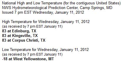
23 F. average high for January 11.
23 F. high temperature one year ago, on January 11, 2011.
Today is the coldest day of the year, based on the latest 30 year weather averages for MSP. Details below.
14 F. today's predicted high. Wind chill: -5. Today may be one of the 3 coldest days of winter.
Trace of snow flurries Wednesday.
Trace of snow so far this month.
"I like these cold, gray winter days. Days like these let you savor a bad mood." - Bill Watterson
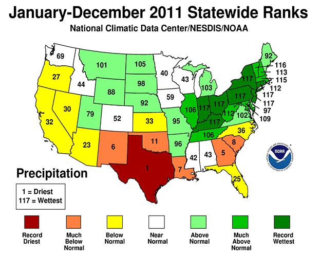
20 cities across the USA experienced the wettest year on record, a new national record for America. Details below.
23 days/row of measurable snow at Fairbanks, Alaska, a new record.
2011-2012: 0
2010-2011: 4
2009-2010: 1
Record Ice Deaths:
1982-1983: 22
2010-2011: 4
2009-2010: 1
Record Ice Deaths:
1982-1983: 22
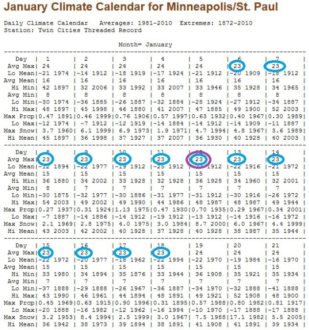
Welcome To The Coldest Day Of The Year (On Average). Weather data from 1981-2010 shows that high temperatures bottom out at 23 F (for maximum temperatures) between January 6 and January 18. The midpoint is January 12/13. I was a bit surprised too, assuming that the coldest weather of the year is late January. Average highs rise from 23 (now) to a whopping 25 by the end of January. Check out the MSP January averages for yourself, courtesy of the Minnesota State Climate Office.
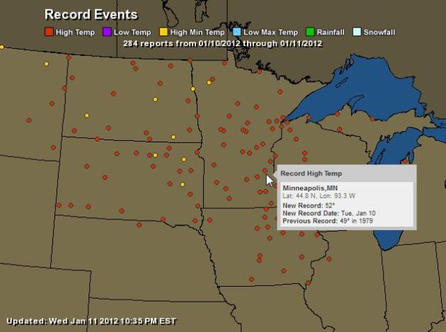
Tuesday Records. Scores of record highs (and record warm minimum temperatures ) were set on Tuesday. Click here for an interactive map, courtesy of Ham Weather.
"Entrepreneurship is the pursuit of opportunity without regard to resources currently controlled." - from an Inc. article highlighted below.
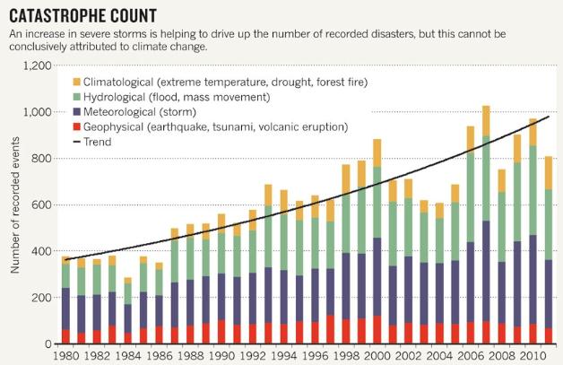
"Since 1980, the report notes, the number of severe floods has almost tripled, and storms have nearly doubled, which insurance experts link, in part, to the impact of climate change. “It would not seem plausible that climate change doesn’t play a role in the substantial rise in weather-related disasters,” says Ernst Rauch, head of Munich Re’s Corporate Climate Centre." - from a story in Nature, details below.

"Electronics are our talismans that ward off the spiritual vacuum of modernity; gilt in Gorilla Glass and cadmium. An in them we find entertainment in lieu of happiness, and exchanges in lieu of actual connections." - from a funny, well-written look at our enfatuation with gadgets and technology from Gizmodo below.
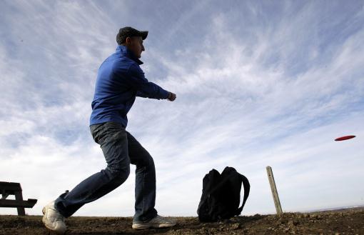
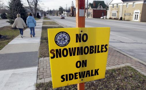
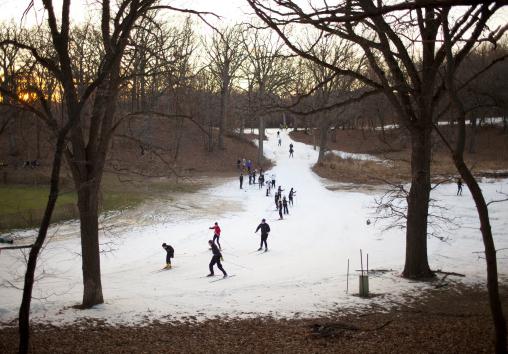
Too Early For Spring Fever? Short Answer: Yes. Unseasonably mild weather was the rule the first 10 days of January from the Upper Midwest into much of the northeastern USA: "In a Monday, Jan. 9, 2012 photo, Jordan Crandall plays a game of disc golf at a popular sledding hill during the mild winter weather in Orchard Park, N.Y. The warm, brown winter that has disappointed snow lovers in much of the U.S. has put more green in the pockets of governments and homeowners whose budgets were busted last year by the high cost of plowing and running roaring furnaces. (AP Photo/David Duprey)."

Waiting For Winter. Not good times for snow-related businesses across the USA: "In a Monday, Jan. 9, 2012 photo, trucks with snowplows are for sale at a business, during the mild winter weather in Newstead, N.Y. The warm, brown winter that has disappointed snow lovers in much of the U.S. has put more green in the pockets of governments and homeowners whose budgets were busted last year by the high cost of plowing and running roaring furnaces. (AP Photo/David Duprey)."
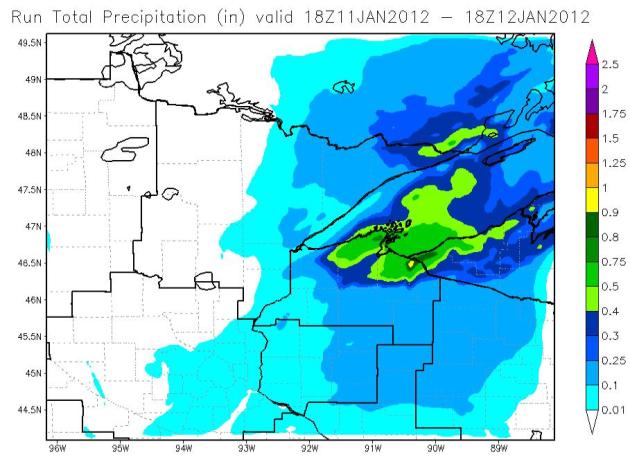
Looking For Snow? It's a bit pathetic, but you may have to drive a few hours to see significant (6-12"+) snows. The Duluth National Weather Service WRF run shows some .8 to .9" precipitation predictions, a foot or more of (lake effect) snow seems likely east of Superior, on up to Ironwood, Michigan, on the Upper Peninsula.
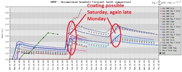
No Significant Snow Looking Out 1 Week. None of the models are hinting at significant snow, a parade of feeble clippers (moving quickly and starved for moisture) may drop a half inch of snow Saturday, maybe another coating Monday night as a reinforcing shot of Canadian air arrives. Pretty exciting stuff, huh? My boredom spells good news for commuters, I guess.
Texas
Houston- Hobby airport 4.06 inches
Lufkin – 2.75 inches
San Angelo SNOW – 2.6 inches/1.38 inches liquid (rain changed to snow)
Dallas-Fort Worth 1.31 inches
Midland SNOW – 10.6 inches/ 0.70 inches liquid water equivalent (mostly snow, some rain very early in event)
Louisiana
Lake Charles 6.26 inches
Lafayette 3.25 inches
New Iberia 2.72 inchesLong Range Forecast? Good Luck: the faster the jet stream winds blow, the more unstable the pattern is, and the tougher it is to make a forecast beyond a few days. Case in point: below was the 12z Wednesday morning run of the GFS model, valid January 27:
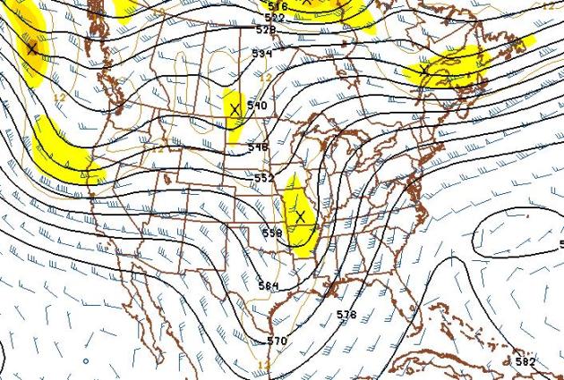
An Abbreviated January? Yes, it's colder, and seasonably cold weather will hang on into much of next week. But check out the latest 500mb (18,000 foot) winds predicted for January 27 (GFS) above. I'm no rocket scientist (my wife reminds me of that daily), but that sure looks like a resumption of a zonal, west-to-east flow, a modified-Pacific pattern with winds aloft blowing from Portland and Seattle, not the Yukon. That should mean a return to 20s and 30s by the last week of January - possibly a better chance of significant snow. A series of troughs, cold wrinkles in the upper level flow, will sweep eastward - it's just a matter of time before one of these is slow and deep enough to tap moisture from the Gulf of Mexico. Then again, we're in a drought - maybe that's just wishful thinking.


1. Don't start a company unless it's an obsession and something you love.
2. If you have an exit strategy, it's not an obsession.
3. Hire people who you think will love working there."
* Photo above courtesy of time.com.


"See everything; overlook a great deal; correct a little." - Pope John XXIII
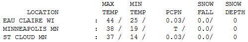

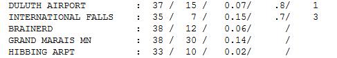
Wednesday Numbers. After a mild start gusty north/northwest winds set in, and temperatures fell through the 30s into the 20s by afternoon, a few hours of light snow and flurries coating the ground in spots. Nearly 1" fell at Duluth and International Falls. Highs ranged from 32 at Alexandria to 37 St. Cloud, 38 in the Twin Cities, and 44 at Eau Claire.
No Kidding. Photo courtesy of David Duprey, Associated Press.
Paul's Conservation Minnesota Outlook for the Twin Cities and all of Minnesota:
TODAY: Mostly cloudy, windy and cold. A few passing flurries. Windchill: -5. Winds: NW 15-25. High: 14
THURSDAY NIGHT: Partial clearing, still gusty, feels like 0 to -10. Low: 4
FRIDAY: Intervals of sun, less wind. High: 18
SATURDAY: Next clipper, coating of light snow/flurries? Low: 13. High: 25
SUNDAY: More sun, milder. Better travel day. Low: 15. High: 33
MONDAY: Some sun, fleeting thaw. Low: 19. High: 39
TUESDAY: Breezy and sharply colder. Blue sky. Low: 13. High: 21 (falling into the teens).
WEDNESDAY: Another clipper; light snow possible up north? Low: 10. High: 29
A "Winter" To Remember
Can you recall a winter this...odd? I can't. This is my 27th winter. We've had warm spells before, but I can't remember anything this off-the-scale. Dan Luna, Chief Meteorologist at the local National Weather Service agrees. "What I am most surprised about is the length of this warm spell. It is very unusual to see a cold spell or warm spell of this significance last a month" he said in a recent e-mail. January is running 15 degrees above average. Implications for the rest of the winter? "It will be hard to have a below normal winter in terms of temperatures. We would have to see a second half of January and all of February well below normal, and we see no indication of that" Luna added.
Is this evidence of climate change? Possibly. A 2-3 F. temperature rise over northern latitudes has loaded the dice in favor of milder, drier winters.
Since 1980 the number of severe storms has doubled, floods have tripled, according to a recent Nature paper. But proving cause/effect with the atmosphere is tricky.
Chicago sees 3-6 inches snow, some 8" amounts over central Wisconsin, while we see a Saturday coating. Another thaw is likely here early next week - I wouldn't be shocked to see freezing Sunday and 40 on Monday, followed by a reinforcing surge of Canadian air next week. No big storms; no prolonged arctic suffering either.
What a strange winter.
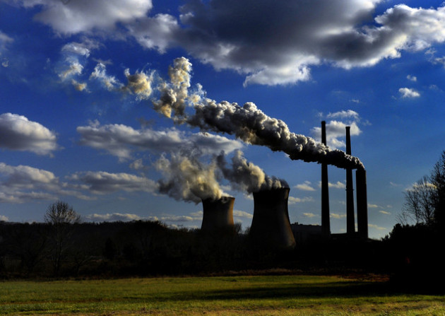
EPA: Power Plants Main Global Warming Culprits. The story from ABC News: "The most detailed data yet on emissions of heat-trapping gases show that U.S. power plants are responsible for the bulk of the pollution blamed for global warming. Power plants released 72 percent of the greenhouse gases reported to the Environmental Protection Agency for 2010, according to information released Wednesday that was the first catalog of global warming pollution by facility. The data include more than 6,700 of the largest industrial sources of greenhouse gases, or about 80 percent of total U.S. emissions. According to an Associated Press analysis of the data, 20 mostly coal-fired power plants in 15 states account for the top-releasing facilities." Photo above courtesy of Bloomberg.

In Big Environmental Speech Obama Thanks EPA, Mentions Climate Change In Passing. An excerpt from a post at Climate Progress: "Because of you, across the board, we’re cutting down on acid rain and air pollution. We’re making our drinking water cleaner and safer. We’re creating healthier communities. But that’s not all. Safeguarding our environment is also about strengthening our economy. I do not buy the notion that we have to make a choice between having clean air and clean water and growing this economy in a robust way. I think that is a false debate. (Applause.) Think about it: We established new fuel economy standards, a historic accomplishment that is going to slash oil consumption by about 12 billion barrels, dramatically reduces pollution that contributes to climate change, and saves consumers thousands of dollars at the pump, which they can then go spend on something else."

Investors Begin To Factor Climate Change Into Investment Decisions. Professionalpensions.com has the story: "Institutional investors worth trillions of pounds are factoring climate change into their investment decisions, a Mercer survey has revealed. The consultant surveyed 12 investors who participated in a previous report on climate change and represent almost $2 trn (£1.3trn) in assets under management. It found that more than half had decided to consider climate change in risk management and asset allocation processes. As the political solution to climate change falters following the Durban negotiations, Mercer global head of responsible investment Jane Ambachtsheer said climate change remained "a significant investment risk for the foreseeable future".
10.3" at the airport, we're closer to 7" up in the far NW metro.
ReplyDelete