28 F. high in the Twin Cities Friday (12:22 am). Afternoon high was only 17 F.
27 F. average high for February 10
12 F. high temperature a year ago, on February 10, 2011.
Snow on the ground 1 year ago today:
18" Chicago
13" Milwaukee
11" Twin Cities
* all 3 metro areas reported 0" on the ground as of Friday morning.
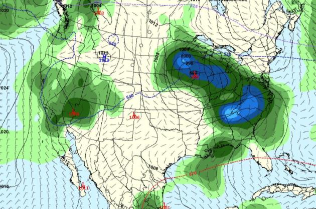
February 21-24: models hinting at significant rain/snow (GFS). It's too early to panic (or celebrate). Details below.
“
The decisions we are making today are going to influence the planet that my daughter inherits and that her children inherit,” Mann said. “That is a very deeply ethical consideration. What sort of planet do we want to leave our children?” - from an article in the Centre Daily Times below.
"
Friends are God's apology for relations." - Hugh Kingsmill
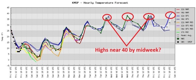
The Worst (Of The Cold) Is Already Behind Us. If you didn't experience subzero temperatures this morning, you may not see any more negative numbers for the rest of the winter season. All the models show a steady warming trend into next week, when we may experience 2-3 days close to 40, some 10-15 degrees above average. Again.
Brainerd Jaycees $150,000 Ice Fishing Extravaganza. Good timing with this current arctic front. After being postponed back in late January (due to unusually mild weather and unsafe ice conditions) it's all systems go for today's event, the largest charity ice fishing contest on the planet. Here's
more information: "
First held in 1991, this event has been postponed only one other time in 2002 and moved to a different lake once in 2006. Hailed as the world’s largest charitable ice fishing tournament with over 10,000 anglers attending annually, event organizers have donated nearly $3-million to Brainerd-area charities, most notably Confidence Learning Center. The volunteer-run event is organized by the Brainerd Jaycees who have over 150 members contributing more than 75,000 hours and $200,000 to the community annually. Find the most up to date event information at www.icefishing.org."
From the
Brainerd Dispatch: "
This year’s tournament is scheduled from noon to 3 p.m. Saturday on Gull Lake’s Hole-in-the-Day Bay. It originally was scheduled Jan. 21, but because of unseasonably warm weather and, in turn, poor ice conditions on Gull, it was pushed back three weeks, just as it was in 2002. “I remember it being much warmer,” Davis, co-owner of Davis & Lang Chiropractic, said of the 2002 contest. “I remember being on the ice the day it was originally scheduled to be held, and as we were measuring the ice we were listening to the radio and it said it was going to be warmer in Brainerd than in Tampa, Fla."
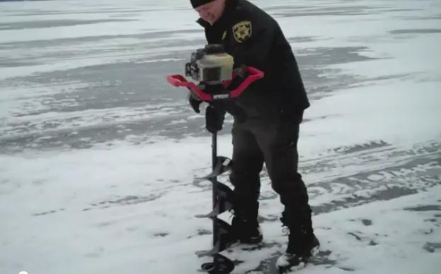
Measuring Ice. The Brainerd Dispatch has a good video covering how officials determine if the ice is safe enough. The
YouTube video is here: "
Crow Wing County Sheriff Todd Dahl displayed the ice thickness at 18 inches in the second hole drilled by the sheriff's office Thursday. The first hole was measured at 17 inches. After the two holes were cut, Dahl confirmed the permit to run the contest would be issued this afternoon."
Read more here: http://www.centredaily.com/2012/02/10/3085096/mann-details-intricacies-ethics.html#storylink=cpy
2012 2011
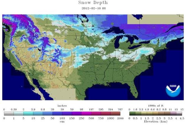
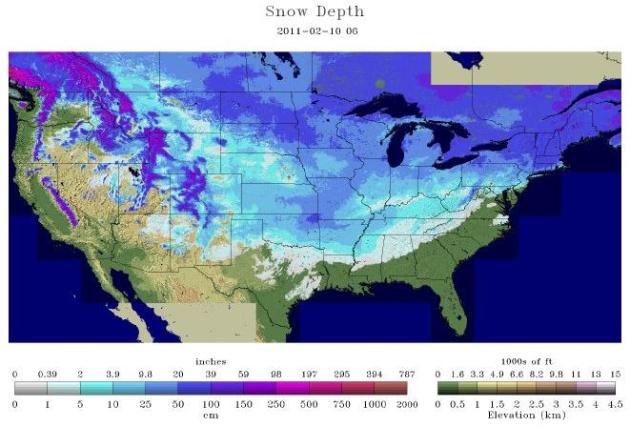
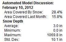
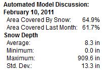
Latest USA Snowcover. According to
NOAA 28.4% of the USA is covered in snow, compared to last year, when
64.9% of America was snowcovered. Average snow depth now: 3" (nationwide). Average snow depth a year ago: 8.3"
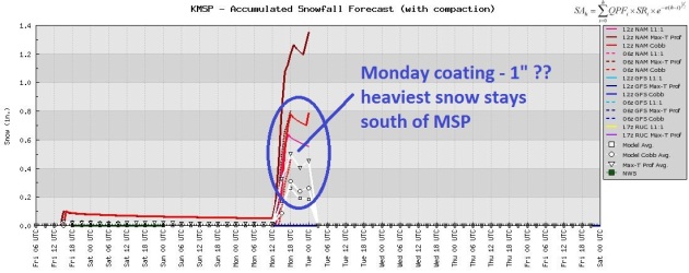
Shocking News: Snow Drought Lingers On. A weak disturbance may brush far southern Minnesota with a little light snow on Monday; little more than a coating to 1/2" of slush possible in the metro. It looks eerily quiet through the end of next week.
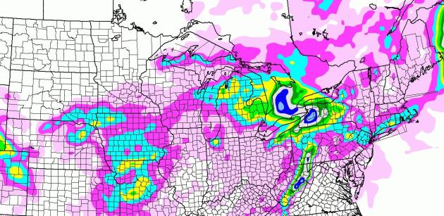
Snowfall Forecast Through Midday Monday. The big story (amidst a downright dull February) is an inch or two from New York City to Hartford, Providence and Cape Cod. Otherwise, the heaviest snow amounts will result from lake effect snow - the suburbs of Buffalo may wind up with 10" snow; closer to 2-4" east of Chicago (around Gary and Hammond). NAM forecast map courtesy of NOAA and WeatherCaster.
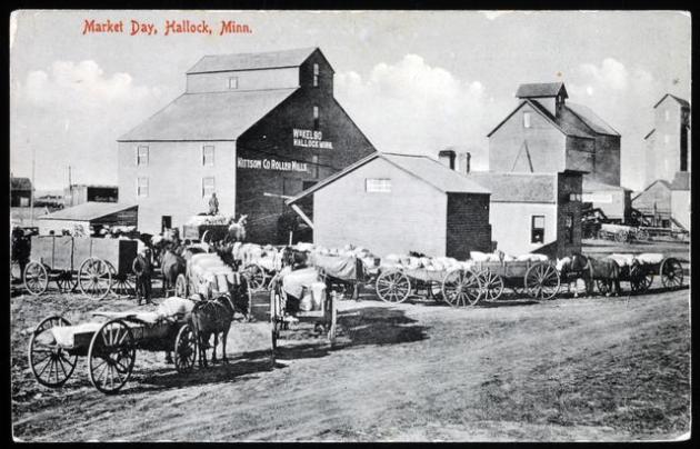
Planting In Spring? According to the MN State Climate Office "meteorological winter" (since December 1) has been the warmest since 1877-78. Dr. Mark Seeley has more on the mythical "Year Without A Winter" (1877-78) in this week's WeatherTalk blog: "
Historical records show that February of 1878 was so mild that many Minnesota farmers were in their fields planting small grains (wheat, barely, oats). Soils had thawed and were not too wet to till. Many observers reported temperatures in the 40s and 50s F for half the days of the month. It is the only time in Minnesota history, that much of the state was planted in the month of February." Photo credit
here.
Winter Snowfall Amounts (courtesy of Mark Seeley):
MSP
14.9 inches (2nd lowest total behind 1930-1931 when 14.2 inches fell)
Austin
13.2 inches (lowest since winter of 1976-1977)
Zumbrota
12.8 inches (lowest since winter of 1962-1963)
St Cloud
16.2 inches (lowest since 1967-1968)
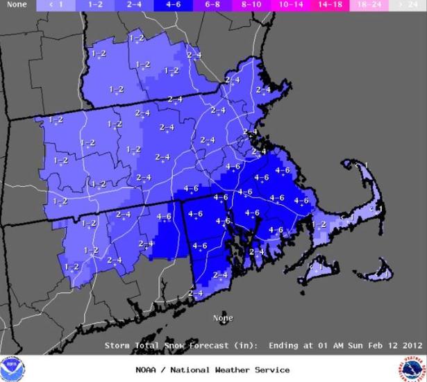
Accumulating Snow On Tap For Boston. From the National Weather Service in Boston: "
After one more dry and mild day today (Friday), a big change to weather will occur this weekend. A developing low pressure system will track southeast of Nantucket on Saturday, bringing accumulating snow to most of the region. The image below are the expected snow accumulations on Saturday. However, the potential for amounts to be a bit lower or higher still exists depending on the exact track, so stay tuned for further updates. The snow will end Saturday evening, with a brief shot of very cold air Sunday into early Monday."
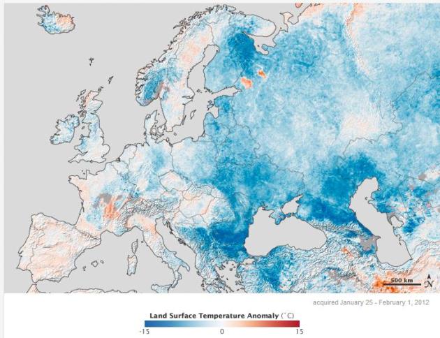
Europe Emerges From The Deep Freeze. Here's a good summary of the record cold gripping much of Europe and Asia, courtesy of NASA's
Earth Observatory: "
Rare snowstorms in Rome and Tripoli and mounting death tolls from exposure were among the consequences of a severe cold snap in Europe in late January and early February 2012. Meteorologist Jeff Masters described it as Europe’s worst stretch of cold weather since February 1991. This map above shows temperature anomalies for Europe and western Russia from January 25 to February 1, 2012, compared to temperatures for the same dates from 2001 to 2011. The anomalies are based on land surface temperatures observed by the Moderate Resolution Imaging Spectroradiometer (MODIS) on NASA’s Terra satellite. Areas with above-average temperatures appear in red and orange, and areas with below-average temperatures appear in shades of blue. Oceans and lakes appear in gray."
Last Week Of February: Zonal Flow. Another warming trend is imminent, and the GFS 500mb forecast for Feb. 26 looks more like mid or late March, with winds aloft howling from Seattle and Vancouver. That should mean rapid weather changes, highs in the 30s (and a few 40s) with little chance of the jet stream buckling sufficiently to pump real moisture into Minnesota. In other words: status quo.
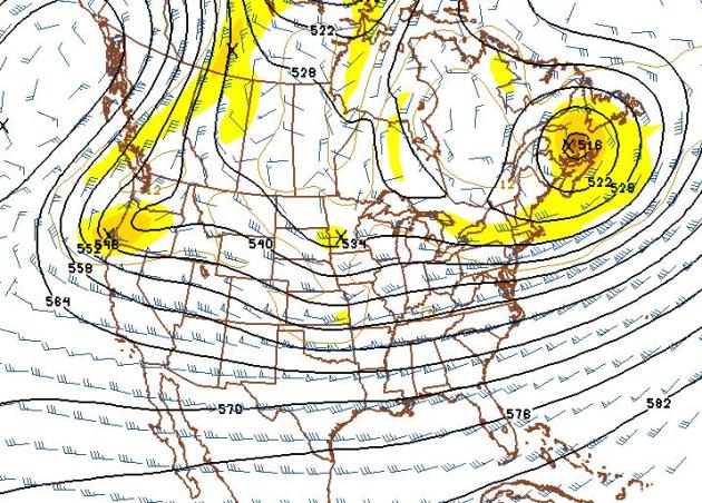
Last Week Of February: Chance Of An Actual Snowstorm? It's way too early to celebrate, but the GFS is suggesting a series of storms between February 21 and 24, possibly warm enough aloft for a mix of rain and wet snow. The models have been pretty awful lately, so my expectations are small, but it's the first real hint of....something I've seen since early December. By the way, we're due.
 Too Early To Celebrate (or panic).
 We've been down this road before, long-range models printing out phantom storms 1-2 weeks out, only to evaporate the next day, the next model run. So I shouldn't even be showing you this. But I
keep few secrets, and this is what the GFS
is printing out for February 23. Mark your calendars. Better yet, let's wait a few days and see if this is a true trend, or a fluke, a computer hiccup.
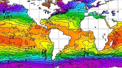
Adios La Nina: Quieter Hurricane Season? La Nina cooling phases of the Pacific correlate with a more active hurricane season (lighter winds over the tropics produce ripe conditions for T-storms to strengthen into tropical storms). Now that La Nina is forecast to wane during the spring months, that may be good news for people living along America's vulnerable coastlines.
ABC News reports: "
Those cooler-than-normal tropical Pacific ocean temperatures known as La Niña are expected to weaken and dissipate this spring, government forecasters said today. La Niña — or the lack of it — could mean good news when it comes to the upcoming hurricane season, said Mike Halpert, deputy director of NOAA’s National Climate Prediction Center. “If we have La Niña, that would argue for an active hurricane season. If you take it away, maybe it takes away some of the activity,” Halpert tells ABC News." Map above courtesy of NOAA.
Q&A For Paul
Hi, Paul!
Will WeatherNation be seen on local Comcast cable? I live in Crystal...hope to be able to see it.
George Carden
George - thanks for taking an interest in WeatherNation, our new, national weather channel that will be available shortly on KARE 11.2. That means free, over the air, as well as local cable systems. Yes, we will be on the local Comcast systems, as well as Mediacom and Charter. Stay tuned for more launch details.
_______________________________________________________________________________
Paul-
Any chance you were awake this morning (Friday morning) around 1:15? I swear I heard thunder. I suppose it could have been the front moving through, because the wind did kick up significantly, but it sure did sound like a 15-20 second long thunder rumble.
Thanks,
Larry
Minnetonka
Larry - not sure what you heard, but it probably wasn't thunder. Winds gusted over 35 mph with the arctic front - it must have been the roar of the wind through the trees. It's rare to get thunderstorms with air temperatures much below 40-50 F. When it's this cold there isn't nearly enough moisture or instability to support the violent upward motion necessary for thunder and lightning. Give it about 30-45 days. At the rate we're going I wouldn't be surprised to see the first T-storms by late March. Let's hope the drought comes to an end, and soon.
_____________________________________________________________________________
Hi Paul!
I get really annoyed when the weather report is wrong. Like the time I planned a garage sale because the forecast was for sunny skies. It poured all day. Boy was I mad! So my question is this. Isn't there a way to rank weather forecasters by accuracy? Like, whose forecast has been closest to the actual weather? Has anyone done this? If I know this I will know where to get my weather report.
Joan Philips
Falcon Heights, MN
Joan - I share your angst, and need to tread carefully here. The sad truth: every meteorologist has good days and bad days. It's a steep learning curve. Anyone can trumpet their best forecasts (and sweep their "busts" under the carpet), but that's pretty dishonest. Personally, I'm partial to Belinda Jensen on KARE-11 (full disclosure: I helped to hire her), but I think the Channel 11 team does a consistently excellent job with the weather. We're lucky: everyone on the air here in the Twin Cities is a professional meteorologist, meaning they went to a 4-year college to learn their stuff. That said, the only way to become a forecaster is to make predictions, get it wrong, and learn from your mistakes over time. Painful at times. There's a company called WeatherRate that goes into specific markets around the USA and runs surveys to try to determine who is most accurate, but I honestly don't know if they do this for the Twin Cities, or if they publish their results. Again, as tedious as this might be, my suggestion is to watch (everyone). See how they do, but don't judge them on one forecast. Snow is the most difficult phenomenon to predict. See who does the best job with the next storm (if it ever snows here again). Over time you'll get a pretty good feel of who does the best job with the forecast. And I'd encourage you to include the Star Tribune weather videos, which are updated frequently during the day. I'm biased, but I think my team of 11 meteorologists at Broadcast Weather do a very good job with Minnesota's ever-changing weather. Thanks for a good question.


.
BGR.com has the details: "
Apple is once again rumored to be going against the wishes of late co-founder Steve Jobs as it prepares to launch a 7-inch version of its popular iPad tablet. While speaking with Computerworld, Technology Business Research analyst Ezra Gottheil said that Apple may be preparing to launch two new products following the imminent release of the iPad 3. One is a case accessory that includes an integrated wireless keyboard, and the second is the oft-rumored iPad mini, which the analyst says will launch later this year."
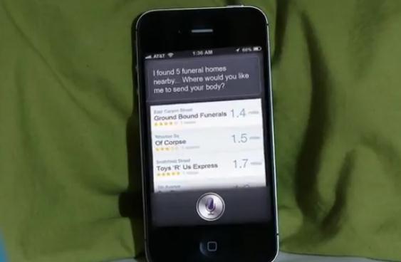
"Siri Is Trying To Kill Me!" OK, I saw this on CNN, thought if was pretty funny - reminds me of HAL in 2001, A Space Odyssey. What happens if there's a bug, a virus, and Siri (Apple's voice recognition program) goes crazy? The
YouTube clip has been viewed over 6 million times - it's worth a look. Rated PG for some salty language.
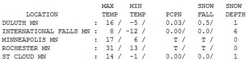
Coldest Day of February? I suspect that was the case - today should be a couple degrees milder, but still 5-10 degrees colder than average. In spite of a bright sun afternoon highs ranged from 8 at International Falls to 14 St. Cloud, 17 in the Twin Cities.
"People who fly into a rage always make a bad landing." - Will Rogers
Paul's Conservation Minnesota Outlook for the Twin Cities and all of Minnesota:
TODAY: Bright sun. Wind chill: 0. Winds: NW 10-15. High: 18
SATURDAY NIGHT: Mostly clear, not quite as cold. Low: 7
SUNDAY: Plenty of sun, closer to average. High: 26
MONDAY: Brushed by flurries. A coating? Low: 15. High: 31
TUESDAY: Intervals of sun, milder. Low: 21. High: 36
WEDNESDAY: Blue sky, quite pleasant for mid February. Low: 23. High: 38
THURSDAY: Mix of clouds and sun, March-like. Low: 25. High: near 40
FRIDAY: Patchy clouds, drizzle? Low: 27. High: 38
Coldest of February
"Isn't it interesting that the same people who laugh at science fiction listen to weather forecasts and economists?" mused Kelvin Throop. Yep. Forecasting the future is not for the faint of heart.
So THIS is what winter feels like? I had almost forgotten how to shiver. Almost. Considering we're enjoying/enduring the mildest meteorological winter since 1878; considering we've seen the least snow since 1930-31, I fear we're losing our coping skills.
This morning MAY have been the last subzero low of winter for much of Minnesota. The sun angle is higher now; we've picked up 86 minutes of additional daylight since December 1, it gets harder to get subzero (highs) into Minnesota by the latter half of February.
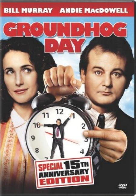
I feel like Bill Murray in the movie "Groundhog Day". Every day is the same, every forecast sounds like it was cloned. "No significant snow...milder than average. Ditto." A dusting of snow is possible Monday, but highs reach the 30s next week, 40 possible by next Thursday.
The last week of February brings more 30s, a few 40s, and a few (nuisance) snows. Still waiting for the big one. Unless the pattern breaks in March we could wind up with a 25 inch winter. Remarkable.
"Do not condemn the judgment of another because it differs from your own. You may both be wrong." - Dandemis
Climate Stories....
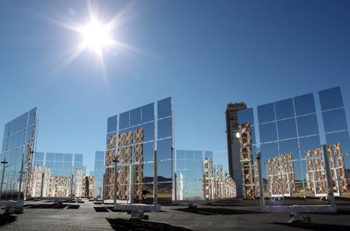
Where The U.S. Solar Industry Is Shining.
Bloomberg Businessweek has the details: "
There’s at least one bright spot in the troubled U.S. solar industry. After a plunge in prices sent panel manufacturers reeling, consumer demand for the alternative energy is soaring. That’s a boon for California companies such as SunRun, SolarCity, and Sungevity. These startups are buying panels at depressed prices and leasing them to homeowners at little or no up-front cost. By teaming up with lenders such as Bank of America (BAC) and U.S. Bancorp (USB) and taking advantage of a federal tax credit for renewable energy, installers can bring down the costs of panels, which for a home typically run between $30,000 to $40,000, and help consumers and businesses reduce the use of fossil fuels. Their success is helping revive the solar industry, which gained notoriety last year from the collapse of panel maker Solyndra."
Photo credit above: "
The sun shines above the field of mirrors that make up the National Solar Thermal Test Facility at Sandia National Laboratories in Albuquerque, N.M., on Thursday, Jan. 26, 2012. Energy Secretary Steven Chu toured the facility on Thursday before hosting a town hall with university students. (AP Photo/Susan Montoya Bryan)."
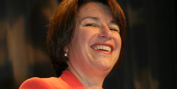
Senator Amy Klobuchar Champions Bipartisan Solutions To Our Energy And Environmental Problems. Here's a blog post at
Fresh Energy: "
On February 9, Senator Amy Klobuchar (D – Minnesota) addressed one of her top priorities in a speech on the floor of the U.S. Senate (watch the video at the bottom of this post):
“…the critical need to get serious about building a new energy agenda for America, one that keeps our businesses competitive in the global economy, preserves our environment and restarts the engine that has always kept our country moving forward, that is innovation.”
She spoke in support of energy tax credits, including extending the production tax credit that made it possible for wind energy to account for over one-third of all new electricity generation capacity installed in the United States in 2011."
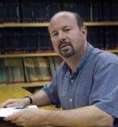
Mann Details Intricacies, Ethics Surrounding Climate Change. Here's an excerpt of an article from the
Centre Daily Times: "
Penn State climate scientist Michael Mann said climate change is often framed as a scientific or economic problem, but it’s also an ethical question. “ Mann, who has been a magnet for criticism, gave the talk at The Penn Stater as part of the university’s forum lunch series. A professor of meteorology known for the “hockey stick” chart on global warming, Mann was part of the team that won a Nobel Prize. He has also been one of the scientists caught up in the “climategate” scandal that followed the release of more than 1,000 emails scientists exchanged.
.....Some of our detractors like to make it like climate science is some sort of lovefest, but it’s not. It’s much more like a street fight,” Mann said. “Scientists — I speak as one — we’re often very opinionated, and we like to be right. And we love to try to prove the other person wrong. “That’s one of the things that makes science the self-correcting process that it is.”
The U.N. Is "Scaremongering" Over Climate Change, Says Energy Boss. Wow - this is pretty unusual, coming from an energy company. I think the ongoing denial (campaign) reflects the fear that laws will be passed preventing energy companies from extracting and burning more coal, gas and oil. That could cost energy companies (and their shareholders) trillions of dollars. There's no question the world needs ever-more energy to fuel growth (and consumption) but just ignoring the science probably isn't the best course of action. No, green energy can't provide all our energy needs today, or even the foreseeable future, but if the proper incentives are put into place, the markets will respond. Less government, more market-driven solutions. I hope that's the direction we go, but who knows? Here's an excerpt of a story in the U.K.
Express: "
An energy firm boss last night accused the United Nations of “scaremongering” over climate change. Chemist Fritz Vahrenholt, of German company RWE, said global warming arguments are supported by “weak science”. He claims reduced solar activity will end up causing the earth to cool down in years to come rather than get hotter. “The climate catastrophe is not occurring,” he said. “In my experience as an energy expert, I learned that the Intergovernmental Panel on Climate Change (IPCC) is more of a political than a scientific body."
Read more here: http://www.centredaily.com/2012/02/10/3085096/mann-details-intricacies-ethics.html#storylink=cpy
Read more here: http://www.centredaily.com/2012/02/10/3085096/mann-details-intricacies-ethics.html#storylink=cpy
Scientists Melt Mystery Over Icecaps And Sea Levels.
Reuters has the story: "
U.S. scientists using satellite data have established a more accurate figure of the amount of annual sea level rise from melting glaciers and ice caps which should aid studies on how quickly coastal areas may flood as global warming gathers pace. John Wahr of the University of Colorado in Boulder and colleagues, in a study published on Thursday, found that thinning glaciers and icecaps were pushing up sea levels by 1.5 millimeters (0.06 inches) a year, in line with a 1.2 to 1.8 mm range from other studies, some of which forecast sea levels could rise as much as 2 meters (2.2 yards) by 2100."
Major Tech Companies Leading The Fight Against Climate Change. The story from
Huffington Post: "
How are some of the world's biggest IT companies taking a stand against a climate change? A list released by Greenpeace this week ranks some of the world's largest information technology companies based on their efforts to mitigate climate change. The fifth edition of the Cool IT Leaderboard puts Google at the top, with Cisco and Ericsson grabbing second and third. According to a press release, the list "ranks 21 IT companies on their clean energy leadership potential, willingness to embrace clean energy solutions and potential to influence energy decisions."
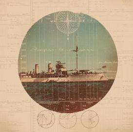
Volunteers Plug Holes In the Climate Records. Here's an interesting story from
Scientific American: "
Kathy Wendolkowski used to make candy in her spare time. for the past year and a half, this mother of three from Gaithersburg, Md., has been spending two to three hours a day on the Web site Old Weather (www.oldweather.org). There she transcribes temperature, pressure and wind-speed records from the logbooks of HMS Foxglove, a British minesweeper that patrolled the South Pacific in the years following World War I. It was a friend, a naval historian, who told her about the site soon after its launch in October 2010, Wendolkowski says."
Photo credit above: "
HMS Foxglove was a British minesweeper that patrolled the South Pacific from 1915 to 1945. Image: Illustration by Mark Weaver. National Archives, England (ship and logbook)."


No comments:
Post a Comment