Todd's Conservation MN Outlook for the Twin Cities and all of Minnesota:
THURSDAY: Some sun. Flurries up north. High: 38THURSDAY NIGHT: Mostly cloudy, a few flurries. Low: 26
FRIDAY: Potential for accumulating snow, especially east of St. Paul. Low: 26. High: 35
SATURDAY: Slow clearing, cool breeze. Low: 21. High: 33
SUNDAY: More clouds than sun, brisk. Low: 19. High: 32
MONDAY: Intervals of sun, turning milder. Low: 18. High: 41
TUESDAY: Early case of spring fever? Nice with plenty of sun. Low: 31. High: near 50
Biggest Snow of the Winter
How about this picture (courtesy WSAW) from Minoqua, where Carrie Schoon Czlapinski picked up almost 18" of fresh snow! For the first time EVER, I got stuck in my driveway. This heavy, wet stuff doesn't move/budge as easy as the fluffy stuff. I spent a good portion of Wednesday afternoon digging out of the DRIVEWAY! It was a long day!

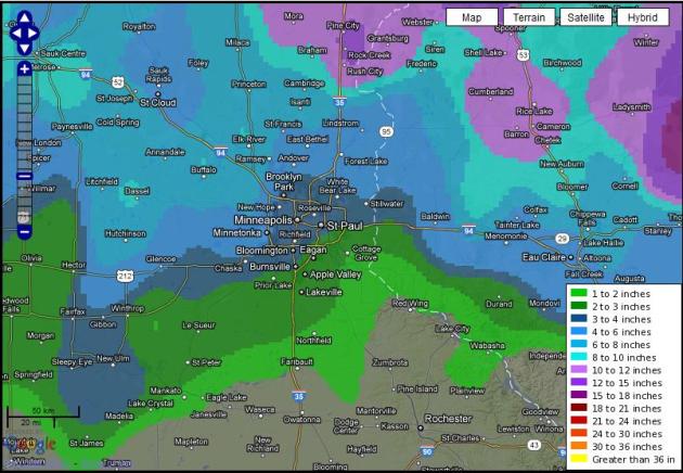
Snowfall Analysis
This is a look at the snowfall analysis from what fell Tuesday night into early Wednesday morning (thru 7am)

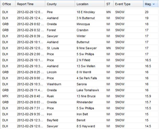
Biggest Snowfall Reports From The Event
These are some of the biggest snowfall reports I could see from the event (which encompassed the entire storm through PM Wednesday). The heaviest reports came out of Wisconsin.
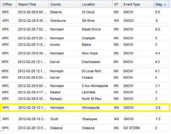
Around the Metro
What a messy forecast! Next time we have a set-up like this... I'll just forecast 1" to 9" across the Metro - good grief!
Actual Reports
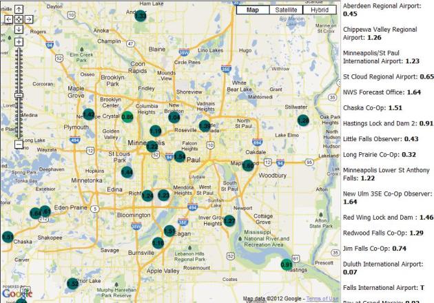
Much Needed Precipitation
Not all the moisture fell in the form of snow, but if it would have, we would have had quite a bit more snow! Here's a look some of the 24 hour precipitation totals (ending at 7am Wednesday).
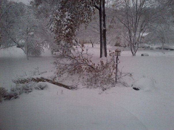
Water-logged Snow Event
The snow was so heavy that it brought down tree, tree limbs and even created power outages. Thanks to Matt Basil for the picture below.
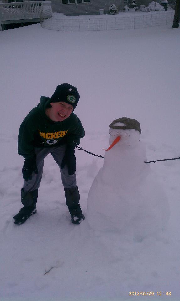
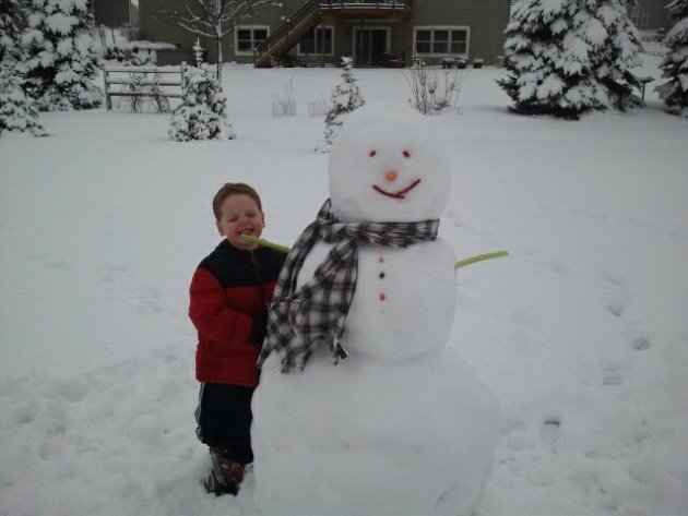
But Good For Snowman & Snowwoman Making
I got a kick out of seeing all the new faces around town! there were lots of creative ideas, and even a candyman!
Thanks Tim Furnish
Thanks Ann Mendenhal Lien
Note the candy face (and trying to be healthy with the celery arms...LOL)
Thanks Jodi Lussier Adkisson
Looks like a nice snowwomen!

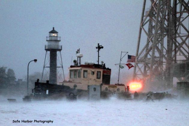
Duluth, MN - Crazy Weather
One of the most interesting spots across the state was in Duluth, MN. This was the scene yesterday in downtown Duluth (Canal Park). Look closely, you can actually see people milling around, watching the storm.
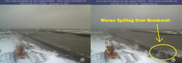
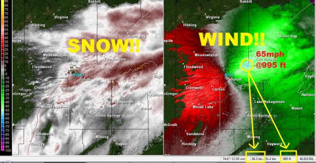
Duluth Blizzard
Duluth was actually in a blizzard warning for a time on Wednesday as several inches of snow piled of snow with 50mph to 60mph + wind gusts blasted the head of the lake.
Friction Free Winds
I love Duluth! The weather is amazing and storms like this make Duluth even more amazing. As a storm approaches from the southwest, intense northeasterly winds develop, which blow across the friction free lake (void of trees, buildings or terrain that would otherwise impede or slow it's progress). The northeasterly wind is then funneled into the head of the lake as the western tip of the lake shore narrows (towards Duluth) and speeds up even more. The result is an intense wind that slaps the western shores of Lake Superior. Yesterday, the winds at 995ft. above the ground (southeast of Two Harbors) came in at 65mph on the radar velocity signature... PRETTY COOL!
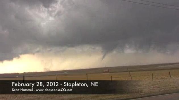
Severe Storms
This storm that also brought severe weather to the mid-section of the nation. In fact, a tornado in Nebraska became the first ever February tornado in Nebraska's recorded history.
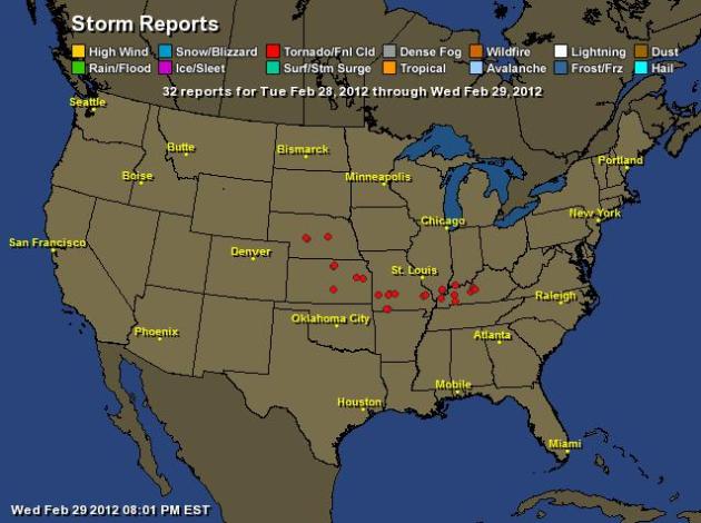
Storm Report Map
CBS News Has More on the Tornadoes
"(CBS/AP) HARRISBURG, Ill. - Twisters roared through the nation's heartland in the early morning darkness Wednesday, flattening entire blocks of homes in small-town Illinois and Kansas and killing at least nine people."

Thanks for checking in and have a great rest of your week.
Don't forget to follow me on Twitter @ TNelsonWNTV
-Meteorologist Todd Nelson-
No comments:
Post a Comment