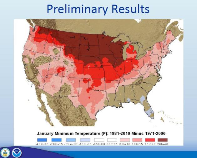
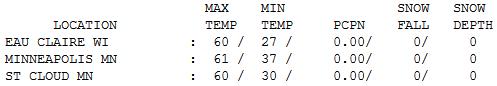
61 F. high in the Twin Cities Friday.
53 F. average high for April 6.
58 F. high temperatures on April 6, 2011.
+13.3 F. The first 5 days of April are running over 13 F. warmer than normal at KMSP.
.04" rain predicted for today (NAM model). Easter Sunday should be a bit sunnier and 1-3 F. milder:
low to mid 60s.
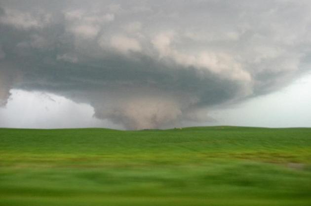
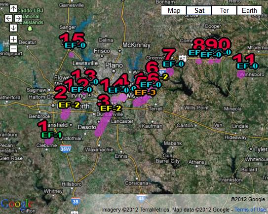
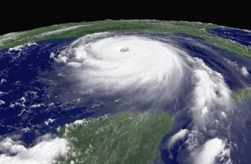
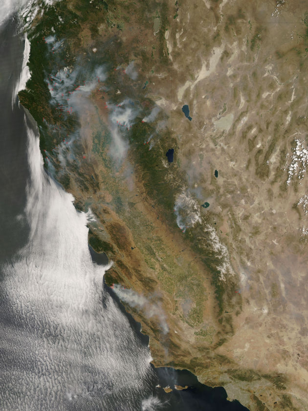
16 separate confirmed tornadoes from Tuesday's Texas tornado outbreak. Source: Ft. Worth NWS office. Details below.
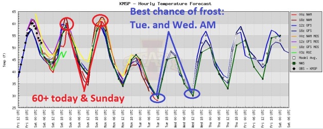
60-ish Today And Sunday, Then A Long Overdue Cool Smack. Yes, after 2 more mild days we'll get a little payback, but pretty timid by Minnesota standards. The best chance of a metro frost: Tuesday and Wednesday morning, followed by a slow warming trend late next week.
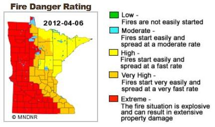
Growing Fire Danger. Here is the latest fire threat map, courtesy of the
Minnesota DNR. There is now an extreme fire danger over roughly the western half of Minnesota, meaning "
the fire situation is explosive and can result in extensive property damage."
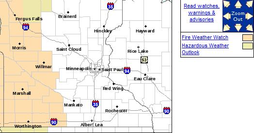
Fire Weather Watch For Western Minnesota. I have a hunch the watch will be upgraded to a Red Flag Warning later today as winds increase - not nearly enough rain to reduce the risk. More from the Twin Cities
NWS:
A FIRE WEATHER WATCH MEANS THAT CRITICAL FIRE WEATHER CONDITIONS
ARE FORECAST TO OCCUR. LISTEN FOR LATER FORECASTS AND POSSIBLE
RED FLAG WARNINGS.
Soil Moisture Still Short, But Improving In Some Places. Here's a snippet from this week's
WeatherTalk blog, courtesy of Dr. Mark Seeley: "
University of Minnesota Research and Outreach Centers monitor soil moisture conditions for Minnesota's major crops. Last fall's (2011) measurements made it obvious that soil moisture storage was well below normal going into the winter season. For many areas over winter and early spring precipitation has been inadequate to help fully restore soil moisture to near normal levels for the spring. At Lamberton the final measurements from last fall showed 2.95 inches of stored soil moisture in the top 5 feet of the soil profile. Measurements made earlier this week showed that the profile moisture content had only "improved" to 3.09 inches of stored moisture, still roughly 2.5 inches less than average for this time of year. Further much of this moisture lies well below 3 feet and is out of the reach of crop rooting systems early in the growing season. So additional spring rains in April and early May are needed to recharge the upper layers of the soil for good germination and early development of corn and soybean crops."
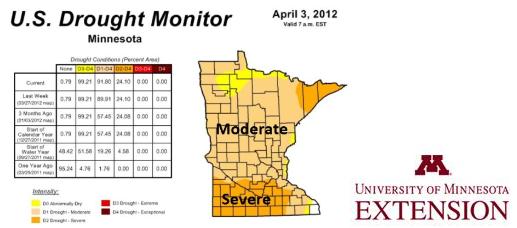
* The latest U.S. Drought Monitor, zoomed in on Minnesota, is
here - courtesy of NOAA.
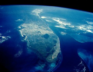
“
The average elevation in Florida is 6 feet,” London said. “Some places are as little as 3 feet above sea level. And sea level is going to rise as all that ice in the Arctic melts.” - from a Climate Central story below.
"
And the key thing then is that we always have weather, some of which is going in the same direction as the climate change. And when we approach those, what used to be limits before, now we're going through them and we're breaking records. And you know, this is sometimes the straw that breaks the camel's back kind of syndrome. You cross the threshold and suddenly you're in a completely different territory, and some bad things can happen as a consequence." - climate scientist Kevin Trenberth, in an NPR interview - details below.
"Averting the worst consequences of human-induced climate change is a "great moral issue" on a par with slavery, according to the leading Nasa climate scientist Prof Jim Hansen." - from a story in The Guardian; details below.
"
The U.S. is not alone in its skepticism that man contributes to global warming – a 2009 Gallup survey found Denmark, the United Kingdom, Norway and the Netherlands were other countries where less than half of respondents blamed global warming on human activity." - from a new poll conducted by the Orange County (California) Register. Details below.
Time For New Tornado Terminology? Is it time to fine-tune the wording used by National Weather Service meteorologists to better capture and communicate the threat-level to people in the path of a tornado? I don't pretend to have the answer key, but after listening to tornado experts for 30 years I would propose the following:
"Tornado Alert": rotation on Doppler radar - conditions ripe for a tornado to form. Stay alert and stay tuned to (multiple) different forms of media to monitor the situation. Be ready to move to a place of safety.
"Tornado Emergency": More emphasis than a garden-variety "Tornado Warning", an "Emergency" would only be issued for a confirmed tornado on the ground, based on SKYWARN spotters, law enforcement, or dual-polarization Doppler detecting a "debris ball", the actual signature of a tornado on the ground. Word the warnings to warn of "catastrophic damage" and "an immediate threat to life and property" to instill a sense of imminent danger to the public.
It's just a thought. The problem: most tornado warnings are "rotation-based", and more than 70% prove to be false alarms. That breeds apathy and cynicism. "They're always issuing warnings - we never see anything." That mindset can prove deadly when a real tornado does touch down, and people in the path don't take the warnings seriously.
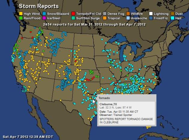
A Week's Worth Of Storm Reports. If you're keeping score (and who among us isn't): 2, 454 storm reports across the USA since March 31. Check out the interactive map, courtesy of one of my companies,
Ham Weather. Yes, I'm a geek, and I'm a bit biased, but I still think the interactivity is pretty cool.
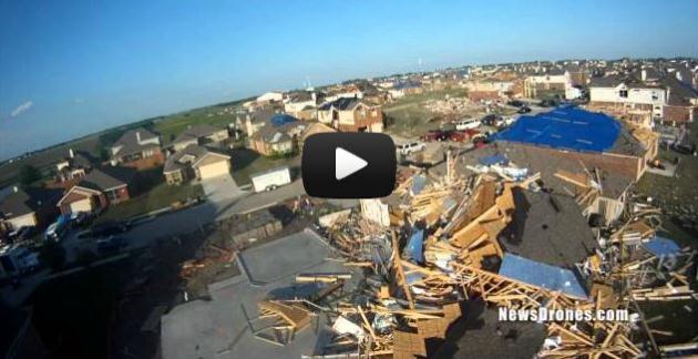
Forney (Texas) Tornado Damage From The Air. Here's a potentially revolutionary way to assess damage in close to real-time: use "news drones". This has amazing implications for covering breaking news too - some of the same technology used by the military is trickling down into civilians (and media) applications. The story from
newsdrones.com: "
This is exclusive aerial video of the damage caused by the Forney, Texas EF3 tornado east of Dallas. The tornado ripped a path through the Diamond Creek subdivision on Tuesday, April 3, 2012. A number of homes were damaged, and some were completely destroyed. The first home you see in the video was wiped down to the foundation in places. A retired woman was in this home, hiding from the storm in her bathroom, when the twister pulverized her house. Miraculously, She survived with no serious injuries."
Tornadoes: Scientists Are Working On A Model To Better Predict Twisters. The Holy Grail (in my humble opinion?) Hyper-local, high-resolution weather models that enable NWS meteorologists to determine, quickly, whether rotation might lead to a minimal EF-0 tornado, or if the atmospheric conditions/environment is ripe for a larger EF-3 twister, capable of extreme damage. We're not there yet, and may not be for another 5-10 years. Hurricane forecasters at NHC know - in close to real-time - whether a hurricane is a Category 2 or a Category 4, and can plan and warn accordingly. The challenge: right now we can't predict, with consistent accuracy, whether rotation on Doppler will lead to a mini-twister, or an EF-4 monster. Once we get a better handle on that, wording can be adjusted to better capture the threat level to the public in the path of the tornado.
WPTV-TV.com has an intriguing story: "
(EndPlay Staff Reports) - Unlike NOAA's Atlantic hurricane forecast released each May, experts are not yet able to predict expected tornado activity. For now, tornado watches typically give people only a few hours' notice that dangerous conditions are brewing. Only a few minutes warning is often available before a tornado actually strikes. Tornadoes in 2011 killed more than 550 people – more than in the previous 10 years combined, according to a news release from Columbia University's Earth Institute. On Tuesday, tornadoes struck the Dallas-Ft. Worth metro region. Scientists are working on a model for better predicting of tornadoes."
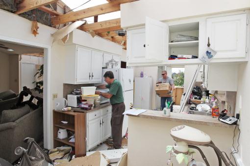
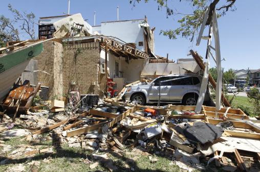
Photo credit above: "
Friends and family of homeowner Brad Smith help salvage what they can from Smith's destroyed kitchen , Wednesday, April 4, 2012 in Arlington, Texas. Preliminary findings indicate one of the tornadoes that struck North Texas had wind gusts ranging from 136 to 165 mph. As many as a dozen twisters touched down across Dallas-Fort Worth. Thousands remained without power Wednesday and hundreds of homes were severely damaged. Officials reported more than 20 injuries, but no deaths. (AP Photo/The Fort Worth Star-Telegram, Paul Moseley)."
16 Confirmed Tornadoes From Tuesday's Texas Tornado Outbreak.
Details from the Ft. Worth office of the NWS:
Tornado number 1 occurred southeast of Joshua, in Johnson county. This tornado produced EF1 damage. The path length was 1.1 miles and the path width was approximately 60 yards wide.
Tornado number 2 occurred in Kennedale and Arlington. This tornado produced EF2 damage. The path length was 4.6 miles, and the path width was approximately 150 yards. This width has been updated from earlier reports.
Tornado number 3 occurred in Lancaster and Dallas. This tornado produced EF2 damage. The path length was 7.1 miles, and the width was approximately 200 yards.
Tornado number 4 occurred in Mesquite. This tornado produced EF0 damage. The path length was 0.3 miles, and the width was approximately 30 yards.
Tornado number 5 occurred near Forney, in Kaufman County. This tornado produced EF3 damage. The path length was 8 miles, and the width was approximately 150 yards.
Tornado number 6 occurred near Royse City, beginning in Rockwall County before moving northeast into Hunt County. This tornado produced EF2 damage The path length was 3.1 miles, and the width was approximately 400 yards.
Tornadoes Fuel $1.2 Billion Monthly Storm Cost In U.S., AON Says. The details from
bloomberg.com: "
Severe weather in the U.S., led by tornadoes in the Midwest and Tennessee Valley, caused more than $1.2 billion of insured losses in March, according to Aon Corp. (AON), the world’s biggest insurance broker. Insurers reported more than 170,000 claims tied to storms from March 2 and 3, London-based Aon said in a report today. The insured losses exceeded $1.1 billion. Severe weather in the Great Lakes region in the middle of the month cost the industry more than $150 million, according to the report."
Photo credit above: "
A home totally destroyed by the tornado on Haverford Dr. in west Arlington, Texas on Thursday Apr. 5, 2012. (AP Photo/Fort Worth Star-Telegram, Ron T. Ennis)."
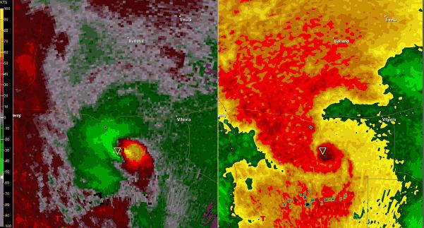
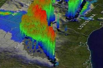
Satellite Spies Texas Tornado Storms In 3-D. Here's a fascinating article from
OurAmazingPlanet.com: "
These images, which were captured around 8:30 p.m. local time, show a line of severe thunderstorms stretching from northeast Texas to Arkansas. The 3-D images show the rate of precipitation produced by the storm clouds: The red areas are spots where the storms dropped 2 inches (5 centimeters) of rain per hour. In some places, the severe storms pelted the ground with hailstones the size of softballs. The National Weather Service initially received reports of 18 tornadoes, but the agency has now confirmed that 14 tornadoes touched down on Tuesday, ranging in strength from an EF-0 tornado on the tornado damage scale, which typically does negligible damage, to an EF-3 tornado packing winds of 150 mph (240 kph)."
Graphic credit above: "
The 3-D profile reveals heavy precipitation."
Mid-April: Rapid Weather Changes, Slightly Warmer Than Average. The jet stream is trending farther south, which should mean temperatures a little closer to average for average. The GFS forecast (above) for April 20 shows a major storm (rain and snow) for Pennsylvania, a zonal west-to-east flow for Minnesota. I see a continued dry bias for the next 2 weeks, which is bad news. I still suspect the drought will get worse.
70s Next Weekend - Potential For Severe Outbreak? I'm not we'll have enough moist, juicy air for a major outbreak, but the GFS is hinting at 70s a week from tomorrow, with well over .50" rain. We've seen this before: the GFS prints out rain, but as we approach the date the precipitation magically vanishes. No snow in sight, if that's any consolation.
Mixed Blessing: Cleaning Up Pollutants Fueled Hurricanes, Study Says. Say what? One more (possible) example of how our actions - sometimes - impact the atmosphere.
MSNBC.com reports: "
It's certainly not what officials had in mind when they curbed industrial pollutants called aerosols, but a new study suggests that doing so has had a big effect on Atlantic Ocean temperatures -- and in the case of the U.S. can be linked to warming seas that fueled hurricanes like Katrina. "When industrial pollution peaked over the Atlantic, this effect played a big role in cooling the ocean beneath," Paul Halloran, a study co-author and ocean scientist with the British government's Met Office weather service, said in a statement accompanying the study. "As pollution was cleaned up -- for example after the clean air legislation of the '90s -- the seas warmed." 3-D hurricane visualization above: NASA.
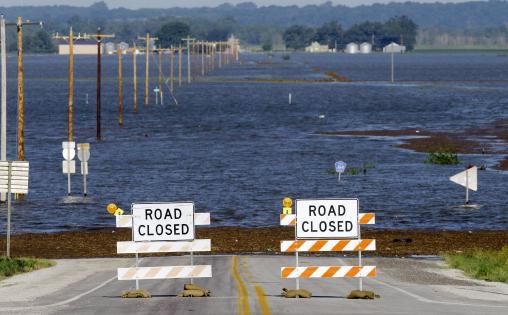
Missouri River Rise Of 2011 Brings Flood Of Information. Forecasters (and the public) were inundated with sometimes confusing and contradictory information during last year's historic 7 month flood on the Missouri River.
Yankton.net has a good story focusing on decision-making under impossible conditions: "
VERMILLION — Major disturbance events — such as the rise of the Missouri River last year — are out of the scope of most researchers and research projects, according to one expert. “We’ll still be understanding this flood decades from now, so it’s going to be very interesting how that information is compiled and brought forward as new people work on it,” said Gerald Mestl, Missouri River program manager with the Nebraska Game and Parks Commission. Mestl discussed some of the effects of last year’s river conditions and the history of flooding along the river as part of the annual Missouri River Institute Research Symposium, which was held Thursday at the University of South Dakota."
Photo credit above: "
Flood waters from the nearby Missouri River cover a county highway, Wednesday, June 15, 2011, in Hamburg, Iowa. The water level continues to rise and officials say that it should crest sometime later this week. (AP Photo/Charlie Neibergall)."
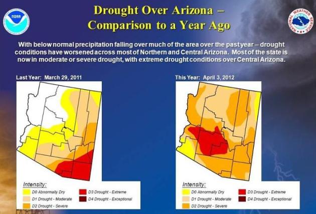
Arizona Drought Worsens. Details from the Flagstaff, Arizona office of the
NWS: "
The drought over Northern and Central Arizona has worsened over the past year...here's a quick comparison of the Drought Monitor graphics which illustrate the worsening conditions."
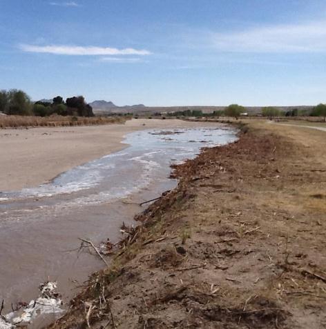
There's Water In The Rio Grande Again! Details from the El Paso, Texas office of the NWS: "
For several months the Rio Grande between El Paso and Las Cruces has been bone dry. On April 1st the Bureau of Reclamation began releasing water from Caballo dam. Almost six days later the water is just now creeping into west El Paso. This photo was taken by meteorologist Tom Bird looking south along the river with the Country Club bridge in the background."
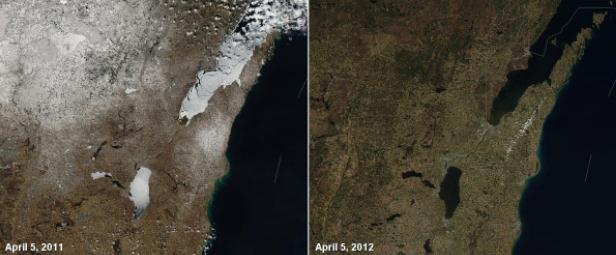
Green Bay - What A Contrast. The satellite image upper left was taken a year ago, showing lingering snowcover and plenty of ice on Lake Michigan. The image upper right was taken on Thursday. Thanks to Jeff Last at the GRB National Weather Service, image courtesy of
twitpic.com.
What Spring? Interested in a little April skiing or snowboarding? Check out condtions from the Park City, Utah Mountain Ski Resort, via
Facebook.
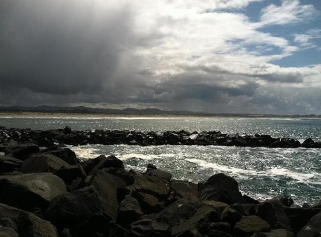
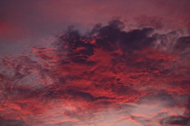
A Wild Sky. Thanks to Sam Carlson, who snapped this photo near Florence, Oregon on Friday.
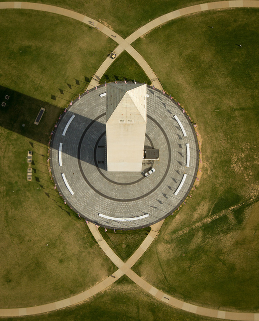
Washington Monument. Here's a new perspective! Thanks to NASA's Bill Ingalls for passing this along - more details on how this photo was taken
here.
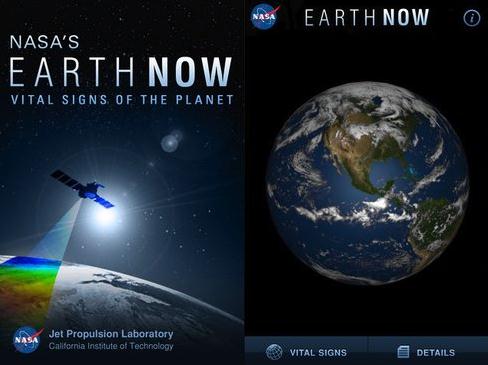
Visualize Climate Data With Free iPhone App From NASA. Treehugger.com has the details: "
They say a picture is worth a thousand words, and in this case, it might just be worth more than that. If the words 'climate change' seem more like trendy buzzwords than something concrete, then perhaps this new app from NASA's Jet Propulsion Laboratory can help you get your head around it. NASA's Earth Now is a free app that uses recent global climate data gathered from Earth Science satellites and displays it on a 3D model of the Earth, letting you visualize a variety of different types of data using "false color" maps. Choose between data sets of the Earth's carbon dioxide and carbon monoxide levels, water vapor, gravity, surface air temperature, ozone, and sea level variations, and rotate or zoom in on the model with just a swipe or a pinch."
Sir Jonathan Ive: The iMan Cometh. If you're a fan of Apple, and the design genius that has catapulted Apple to become more than a company and more of a lifestyle, here's an excerpt of an interview you don't want to miss - from
The London Evening Standard:
Q: How does a new product come about at Apple?
A: What I love about the creative process, and this may sound naive, but it is this idea that one day there is no idea, and no solution, but then the next day there is an idea. I find that incredibly exciting and conceptually actually remarkable.
The nature of having ideas and creativity is incredibly inspiring. There is an idea which is solitary, fragile and tentative and doesn’t have form.
What we’ve found here is that it then becomes a conversation, although remains very fragile.
When you see the most dramatic shift is when you transition from an abstract idea to a slightly more material conversation. But when you made a 3D model, however crude, you bring form to a nebulous idea, and everything changes - the entire process shifts. It galvanises and brings focus from a broad group of people. It’s a remarkable process.
Snakes On A Plane - For Real! No, I didn't believe it either, until I read this story from the AP and
The Washington Post: "
CANBERRA, Australia — An Australian pilot said he was forced to make a harrowing landing reminiscent of a Hollywood thriller after a snake popped out from behind his dashboard and slithered across his leg during a solo cargo flight. Braden Blennerhassett — unsure whether the snake was venomous — said Thursday that his heart raced as he tried to keep his hands still while maneuvering the plane back to the northern city of Darwin. The snake popped its head out from behind the instrument panel several times, Blennerhassett said, and then the ordeal worsened when the animal crawled across his leg during the approach to the airport."
Perfect Good Friday. I know, I shouldn't editorialize. In spite of the drought, and the fire risk over western Minnesota, it was hard not to fall in like with Friday's weather: light winds, low humidity, highs in the low to mid 60s. Friday highs ranged from 60 at St. Cloud to 61 in the Twin Cities, to 65 at Redwood Falls, a good 10 degrees above average.
Paul's Conservation Minnesota Outlook for the Twin Cities and all of Minnesota:
TODAY: More clouds than sun, windy and mild; passing shower possible. Winds: W 15-30. High: 62
SATURDAY NIGHT: Showers taper over Wisconsin, partial clearing. Low: 43
EASTER SUNDAY: Partly sunny, - still mild. A dry Easter this year. Winds: W 10-20. High: 64
MONDAY: Jacket weather, turning cooler - frost up north early. Low: 39. High: 49
TUESDAY: Frost possible, especially outlying suburbs. Bright sun. Low: 33. High: 48
WEDNESDAY: Better chance of frost in the suburbs - probably frost-free downtown. Blue sky. Low: 31. High: 52
THURSDAY: Clouds increase. Storm stays well south of Minnesota. Low: 37. High: 55
FRIDAY: Intervals of sun, mellowing a bit. Low: 39. High: near 60
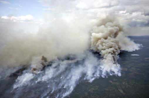
Fire Weather
The supernaturally brave and hardy homesteaders who moved to Minnesota, sight unseen, in the early 1800s had to grapple with unimaginable threats. Journals from Fort Snelling show a very healthy respect for tornadoes, floods and blizzards. Their biggest fear: brushfires. Imagine a 30-foot wall of flames racing across the prairie at 40 mph. There was nowhere to go, unless a lake or pond was within distance of a mad dash. Fire survivors told harrowing tales, of soaking burlap in water and covering their bodies, praying out loud the flames would spare them.
We've come a long way; we no longer have to live in mortal fear of fire - but the risk hasn't dropped to zero. According to the MN DNR there is an extreme fire danger over western Minnesota, meaning "situation is explosive; can result in extensive property damage." We need rain, but I don't see any significant storms peering out 2 weeks into the future.
Today's cool front sails through town dry; highs top 60 through Easter. The real surge of chilly air doesn't arrive until Monday - keep a jacket handy; you'll need it the first half of next week.
A metro frost is possible Tuesday & Wednesday "Cover your begonias!" We should rebound to 60 late next week. Mean date of the last 32 at MSP? April 28.
It's payback time.
Photo credit above: "
In this Sept. 13, 2011 file photo, smoke rises from a fire in the Boundary Waters Canoe Area Wilderness in northeastern Minnesota. The U.S. Forest Service currently expects 76 campsites will still be closed because of safety concerns when the 2012 season opens in a popular part of the area that was blackened by the huge forest fire. (AP Photo/The Duluth News-Tribune, Clint Austin, File)."
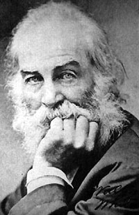
"
There's a man in the world who is never turned down, wherever he chances to stray; he gets the glad hand in the populous town, or out where the farmers make hay; he's greeted with pleasure on deserts of sand, and deep in the aisles of the woods; wherever he goes there's a welcoming hand - he's the man who delivers the goods." - Walt Whitman.
Photo credit.
Climate Stories....
Link Between Extreme Weather And Climate Change. Here's an excerpt of an interview with noted climate scientist Kevin Trenberth, on
NPR. It's worth checking out the full transcript of the interview; here's a snippet:
"TRENBERTH: Spring has been moving up. It has been generally the case, but - this year especially so. And the tornado season seems to have moved up as well.
CONAN: And that means there are going to be more of these storms, no?
TRENBERTH: Well, you know, tornadoes vary quite a lot from year to year, and they depend on other factors, as to whether the jet stream is in just the right location and certainly the warm moist air coming out of the Gulf. And, you know, that's part of the climate change aspect, is that the air coming out of the Gulf is a bit warmer and moister. And so it helps to invigorate the thunderstorms that host these tornadoes. So that is one factor that's underplayed, but there is a lot of variability, of course, from year to year."
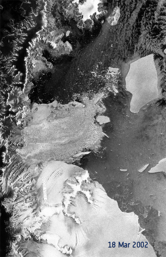
Proof Of The Disintegrating Arctic Ice Shelf; China's Weird Weather. Here's a story (and great time-lapse photo sequence) from
The Atlantic Wire: "
Perhaps you're a visual learner? Or maybe you just can't believe stories without photo evidence. Well, now you have some! From a European Space Agency Satellite, we get these images of the ice shelf over the last 10 years in GIF form. Over the last decade, the ice shelf has disintegrated by 1790 sq km, which is about as big as the biggest island of the Galapagos. Granted, this shelf has seen it worse than most other areas of the world. "The northern Antarctic Peninsula has been subject to atmospheric warming of about 2.5°C over the last 50 years -- a much stronger warming trend than on global average, causing retreat and disintegration of ice shelves," said researcher Helmut Rott. But, geez, that's a lot of ice meltage. [ESA]"
Ice Age Study Delivers Blow To Global Warming Skeptics. The story from
The Christian Science Monitor: "
Rising levels of carbon dioxide drove much of the global warming that thawed Earth at the end of the last ice age. That's the conclusion a team of scientists has drawn in a new study examining the factors that closed the door on the last ice age, which ended about 20,000 years ago. The result stands in contrast to previous studies that showed temperatures rising ahead of increases in atmospheric CO2 levels. This has led some skeptics of human-triggered global warming to argue that if warming temperatures came first, CO2 wasn't an important factor then and so can't be as significant a factor today as most climate scientists calculate it to be."
Photo credit above: "
Changed patterns of deep sea circulation resulted in less sea ice around Antarctica at the end of the last ice age, part of a broader process that led to an influx of carbon dioxide in the atmosphere. This photo shows Antarctic sea ice today. Alister Doyle/REUTERS/File."
NASA Scientist: Climate Change Is A Moral Issue On A Par With Slavery. The story from the U.K.
Guardian: "
Averting the worst consequences of human-induced climate change is a "great moral issue" on a par with slavery, according to the leading Nasa climate scientist Prof Jim Hansen. He argues that storing up expensive and destructive consequences for society in future is an "injustice of one generation to others". Hansen, who will next Tuesday be awarded the prestigious Edinburgh Medal for his contribution to science, will also in his acceptance speech call for a worldwide tax on all carbon emissions. In his lecture, Hansen will argue that the challenge facing future generations from climate change is so urgent that a flat-rate global tax is needed to force immediate cuts in fossil fuel use."
Photo credit above: "
Prof Jim Hansen: 'We’re handing future generations a climate system which is potentially out of their control'. Photograph: Melanie Patterson/AP."
Poll: Many Conservatives Doubt Global Warming. Here's an excerpt from
The Orange County Register: "
Among Orange County Republicans polled, 69 percent say man does not contribute to global warming or that there is no global warming. Among Democrats here, 98 percent say man does contribute to global warming. These findings by the OC Political Pulse poll portray an even starker partisanship than shows up in a Gallup nationwide poll, perhaps because OC Political Pulse participants signed up for the polling project and so may be more politically engaged and ideological than those randomly phoned by Gallup. Even more striking: Among county Republicans, 44 percent say no global warming is taking place. Among Tea Party identifiers, 54 percent say there's no global warming."
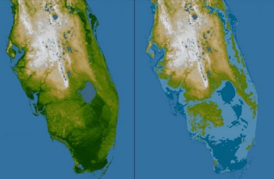
The Future Is Now For Sea Level Rise In South Florida. Here's an excerpt of a post from
Climate Central: "
It’s not unusual for Keith London to run into people who doubt that global warming is really such a big deal. “I tell them, ‘the ocean is rising,’ ” he said. “They say, ‘so?’ It drives you crazy.” London is no scientist; he’s a city commissioner in Hallandale Beach, Fla., a municipality of about 37,000 that sits on the Atlantic coast between Fort Lauderdale and Miami. But he talks to scientists and engineers all the time as part of his job, and the story they tell him isn’t pretty. “The average elevation in Florida is 6 feet,” London said. “Some places are as little as 3 feet above sea level. And sea level is going to rise as all that ice in the Arctic melts.”
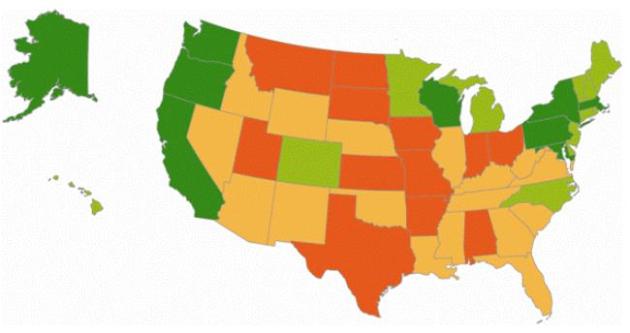
Ready Or Not: Is Your State Prepared For Climate Change? Here's a story from a senior attorney at the NRDC, the Natural Resources Defense Council, at
Huffington Post: "
Every state in the U.S. is vulnerable to the water-related impacts of climate change, but a new 300-page report from NRDC reveals that 29 states are failing to adequately prepare for these impacts. Only nine states have undertaken comprehensive planning efforts. Meanwhile, six states -- Alabama, Indiana, Kansas, North Dakota, Ohio and South Dakota -- have not taken any meaningful action to prepare for climate change or to address the climate pollution that threatens our communities and the economy."
California At Top In Climate Change Preparedness. More details from
The San Francisco Chronicle: "
Scarce water supplies and coastal flooding may be part of California's future, but the Golden State is as ready as any state to tackle those and other problems caused by climate change, according to a national study released Thursday. California is one of only nine states that have developed comprehensive strategies and implemented policies to deal with water shortages, droughts, a shrinking snowpack and other water-related problems that are expected to occur if global temperatures increase this century as predicted by scientists, the Natural Resources Defense Council report said." Image credit: NASA.
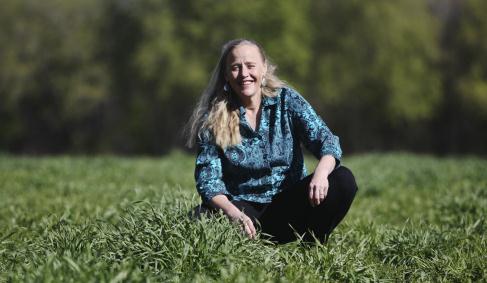
Many Corn-Belt States Unprepared For Climate Change. The story from
cattlenetwork.com: "
The Natural Resources Defense Council released a new report ranking states in terms of how their governments have addressed the challenges posed by climate change. The report shows that many Corn Belt states rank in the bottom two categories of four category ranking system NRDC created for the report. Since many Midwestern states don’t have as many water challenges, their governments do not appear to be as focused on setting climate change directives. NRDC’s report focuses on how state governments across the nation are planning and preparing for the water-related impacts of climate change. These impacts include more severe and frequent storms, intense rainfall, sea-level rise, warmer water temperatures and drought events." Photo: David Joles, Star Tribune.
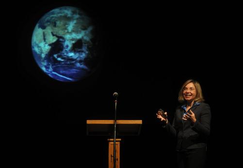
Report Finds Texas Lags In Preparing For Climate Change. Details from
The Houston Chronicle: "
Texas lags behind most states in planning for the unavoidable impacts of climate change on its landscape and economy, according to a national report released Thursday. The Natural Resources Defense Council (NRDC), which prepared the report, said Texas must work not just to curb emissions of carbon dioxide and other heat-trapping gases, but to prepare for rising sea levels and declining water supplies. The environmental group lumped Texas with 11 other states that have no strategy for responding to the effects of climate change, particularly those related to water. Texas' ongoing drought clearly shows its vulnerability to higher temperatures and changes in rainfall, said Steve Fleischli, director of the NRDC's water and climate program."
Photo credit above: "
Climate scientist Katharine Hayhoe delivers her Faith Based Response to Climate Change talk to students and faculty during chapel at Hardin-Simmons University Tuesday, April 3, 2012, in Abilene, Texas. (AP Photo, Abilene Reporter-News/Nellie Doneva)."
Global Warming Affects Russia More Than Others - Meteorologists. From
RT.com: "
Russia is suffering from global warming more than any other country, say state meteorologists. The weathermen’s latest report focuses on climate indicators in 2011, as well as on the trends of the last 35 years. The scientists say that climate change in Russia appears to be double that in other countries. In the last 35 years, the average temperature in Russia went up by 1.5 degrees, while the average figure across the world is 0.8 degrees. “The report shows that global warming is not a gradual process,” said Aleksey Kokorin, the head of WWF Russia climate service. “Although the average temperatures are going up slowly, the temperatures’ actual leaps are 10 times bigger. The number of alarming climate phenomena has gone up by two times.”
Video credit above:
"Spring" in Moscow (RIA Novosti / Vladimir Astapkovich).
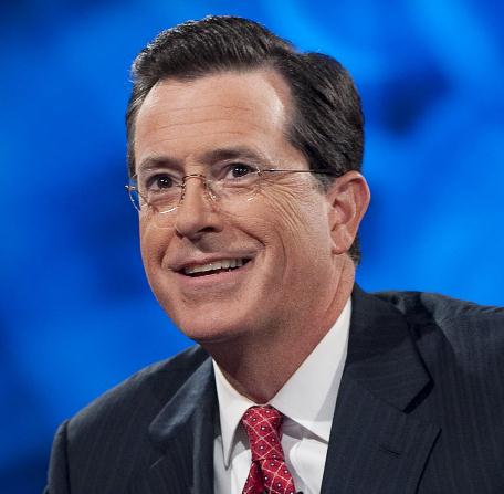
Stephen Colbert: Scientific Pioneer? Here's a fascinating post from Chris Mooney - check out the full story at
Huffington Post: "
In my last post here, I explored what I called the science of "truthiness": How we can come to understand the denial of science, on issues like global warming, by examining the underlying psychology of political conservatism itself. But I must confess that in that item, I was relying on a fairly clichéd understanding of the word "truthiness." Since it was first coined by Stephen Colbert in 2005, the term has taken on a massive life of its own -- coming to mean, in its broadest sense, the problem of people making up their own reality, one just "truthy" enough that they actually believe it. Frankly, though, most of us only have a "truthy" sense of what "truthiness" actually meant in its original formulation."
Photo credit above: Scott Gries/PictureGroup.
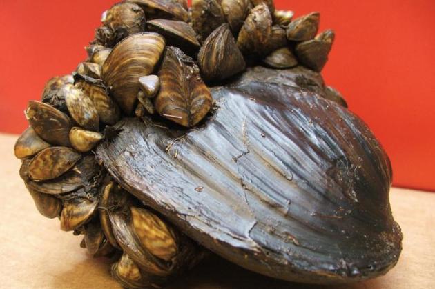
Fending Off Invaders In A Warmer Climate.
NOAA has the story: "
Invasive species come in many shapes and sizes; some might even be swimming around in your aquarium right now. But one characteristic that many of them share is that they tend to thrive under a wide range of environmental conditions, giving them an advantage in the face of climate change. In the Great Lakes region, conservation and resource managers are already fending off attacks by multiple invasive species while trying to anticipate what might happen in the future. One of the region’s most prolific invaders from the past several decades is the zebra mussel. Since the arrival of this invasive species, zebra mussels have all but eliminated native mussels by attaching to their shells (demonstrated in the photo above), inhibiting their movement, and competing with them for food."
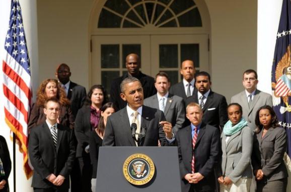
Fossil Fuel Subsidies: Helping The Richest Get Richer. Here's an excerpt of a story at
The L.A. Times: "
Last week, the Senate voted on a proposal by New Jersey Sen. Robert Menendez to end some of the billions of dollars in handouts enjoyed by the fossil-fuel industry. The Repeal Big Oil Tax Subsidies Act was a curiously skimpy bill that targeted only oil companies, and just the five richest of them at that. Left out were coal and natural gas. Even so, the proposal didn't pass. But that hasn't stopped President Obama from calling for an end to oil subsidies at every stop on his early presidential-campaign-plus-fundraising blitz. And this month Vermont Sen. Bernie Sanders will introduce a much tougher bill that tackles all fossil fuels and their purveyors."
Photo credit above:
"US President Barack Obama delivers remarks urging Congress to vote on the 'Repeal Big Oil Tax Subsidies Act', as supporters look on, in the Rose Garden of the White House in Washington D.C. (Michael Reynolds / EPA / March 29, 2012)."


No comments:
Post a Comment