70 F. high in the Twin Cities Monday, 8 degrees shy of a record.
51 F. average high for April 2.
54 F. high temperature a year ago, on April 2, 2011.
3.4" snow fell on April 2, 1920. Good grief.
3.1" snow falls on KMSP during an average April. There's a nugget that'll cheer up a friend. Source:
NOAA.
Frost risk remains for next week, as early as a week from this morning. Expect 2, maybe 3 nights at or below freezing for the Twin Cities suburbs next week, followed by a significant warming trend after April 16 or so.
 "Step Away From The Annuals."
 The more I look at the models, the more convinced I am that much of the metro will see a frost the first half of next week, anywhere from 1-3 nights at or below 32. It's too early to know if it'll be a killing freeze (3-4+ hours colder than 28 F.) but I could see some frost damage in about one week. You've been warned.
Red Bud Tree courtesy of Joan Kruhoeffer in Lancaster, PA.

"
There is not a shred of political correctness in what the military is doing with energy efficiency or renewable energy," said Dennis McGinn, a retired Navy vice admiral who now serves as president of the D.C.-based American Council on Renewable Energy and as vice chair of the military advisory board for CNA, a 70-year-old think tank that began as a Naval antisubmarine research group during World War II. "From lance corporal to general, they are on board. They live with the problems from the over-reliance on fossil fuels." - from a Scientific American article on the military preparing for climate change, details below.
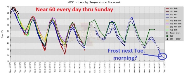 A Mild Week, Then Frost?
 The models are in pretty good agreement - temperatures only 10 degrees above average through the weekend, followed by a real cold front early next week.
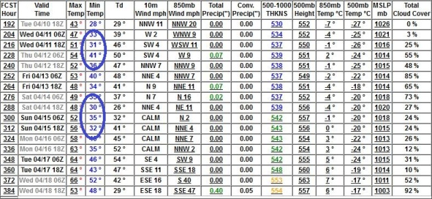 Frost Potential Next Week.
 Latest (GFS) runs aren't quite as cold as they were a few days ago, but there's a potential for frost (especially suburbs) from Tuesday morning through Saturday morning. Right now it doesn't look like a widespread freeze (few hours below 28) but it's still too early to know for sure. Don't pack away the (light) jackets just yet.
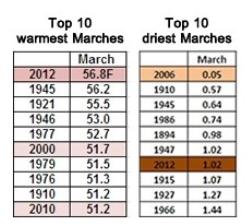
Warmest March On Record For Washington D.C. Area. From Matt Rogers at the always-excellent
Capital Weather Gang at The Washington Post: "
Our very warm March has come to a close and not only was it the warmest on record (since 1871), but it also extends our streak of above normal monthly temperature averages to 5 months in Washington, D.C. The warm March pattern brought about an explosive start to spring. The D.C. cherry blossoms had their earliest peak (3/20) since March 2000 (3/17)."
Graphic credit above: "
Top 10 warmest Marches on record (left), top 10 driest Marches on record (right) in Washington, D.C. (Years in top 10 since 2000 highlighted.)"
March 6 March 20
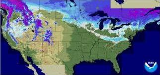
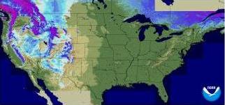
Fast-Forward Melt-Down. This
NOAA animation shows the amazing rate of snow-melt last month.
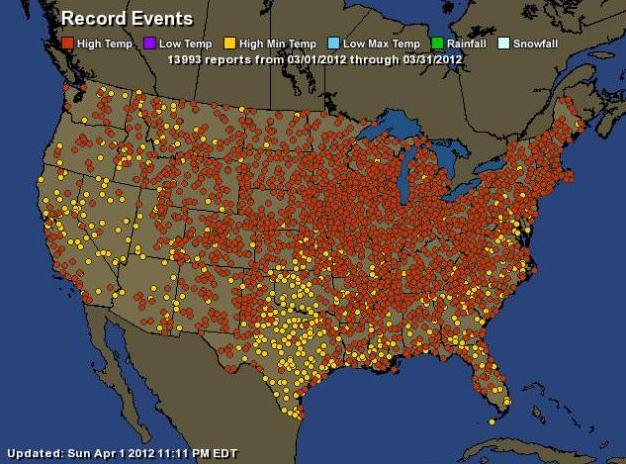
Feds: "Meteorological March Madness" Mostly Random. ABC News has the story; here's an excerpt: "
The National Oceanic and Atmospheric Administration analyzed the causes and chances of what it nicknamed "meteorological March madness." Meteorologist Martin Hoerling said the main cause was a persistent warm wind sending toasty air north from the Gulf of Mexico. The study is not peer-reviewed and some outside scientists say it is short-sighted. "Climate change was certainly a factor, but it was certainly a minor factor," Hoerling said. He said the bigger issue was wind patterns. Low pressure in the Pacific Northwest and high pressure in New England created a perfect funnel, like the gutter lane in a bowling alley, for warm air in the Gulf of Mexico to head north."
The 2012 "Eastern Heatwave".
NOAA has a very good explanation of what happened last month, mostly meteorology (strong blocking pattern, Bermuda high and unusually warm air from the Gulf of Mexico streaming north over snow-less ground), but most experts believe a warmer atmosphere - influenced by a warming climate - may have turbo-charged some of these records: "
Conditions more fitting of June than March prevailed east of the Rocky Mountains since the start of the month. The numbers are stunning. Take, for example, the nine consecutive record high temperatures in Chicago from 14-22 March, eight of which saw the mercury eclipse 80°F. For those unfamiliar with the area’s climatology, high temperatures do not normally begin exceeding 80°F until after commencement of the Summer solstice. NOAA’s National Climate Data Center reported that over 7000 daily record high temperatures were broken over the U.S. from 1 March thru 27 March. With beachgoers flocking to the balmy shores of Hampton Beach, New Hamsphire this week, one wonders if a new normal is emerging for the preferred destination of Spring-break revelers."
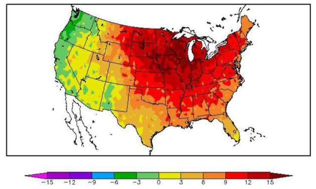
A March To Remember. Temperatures from the Great Plains to the Upper Midwest, Great Lakes and much of the Northeast were 9-18 degrees F. above average. Details from
NOAA: "
Temperature departures from normal for March 2012. South Florida was 2 to 4 degrees warmer than normal for the month. Much higher temperature departures occurred over the Great Lakes, Midwest and Northeastern United States corresponding to the location of the stronger-than-normal high pressure cell."
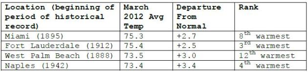
Even South Florida Experienced A Warmer Than Normal March. Most cities were 2-3 F. warmer than average last month. More information from
NOAA.
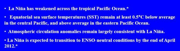
La Nina Weakens. And a good riddance to you, La Nina. What I find almost supernaturally odd: America (lower 48 states) had the 4th warmest winter, in spite of a La Nina ENSO cooling phase in the Pacific. Very odd. We're transitioning into an ENSO-neutral phase this summer, with a growing chance of moving into an El Nino (warming) phase later in 2012 and 2013, which more strongly correlates with a warmer bias downwind, over North America. If that's the case we might expect fewer hurricanes in late summer and fall, and an even milder winter season next year. That's pure speculation - all bets are off. For more than you ever wanted to know about the current ENSO phase,
click here for a pdf, courtesy of NOAA.
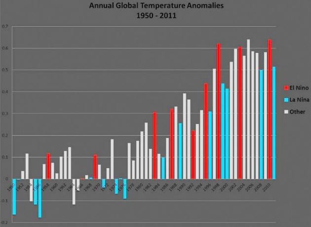
La Nina Has Been Neutered. The data doesn't lie - you may not like the data, but the graph above shows a statistically significant trend since about 1978-1980. In years gone by (60s and 70s) El Nino correlated strongly with warmer weather, La Nina cooling phases in the Pacific usually resulted in a cold bias. No more. Now the phase doesn't seem to matter; both El Nino and La Nina phases wind up producing warmer temperature anomalies (El Nino phases - in red - still trend a little milder). ENSO trends since 1950 courtesy of
NOAA NCDC.
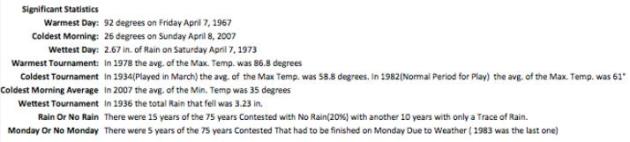
Weather For "The Masters". Rumor has it there's a big golf tournament in Augusta, Georgia this week. Here are a few weather nuggets related to weather for The Masters:
Warmest Day: 92 degrees on April 7, 1967
Coldest Morning: 26 degrees on Sunday April 8, 2007
Warmest Tournament: In 1978, the avg. of the Max Temp was 86.8 degrees
* the latest outlook for weather at The Masters is
here, courtesy of Ham Weather.
"Where Have All The Flowers Gone?" Our fast-forward spring is showing up in unexpected spots, like Augusta.
ESPN reports: "
AUGUSTA, Ga. -- Something is missing from the Masters this year, a tradition that ranks right up there with Amen Corner, endless roars on Sunday afternoon and the winner's green jacket. Color. Red, pink and white azaleas that typically are ablaze for the opening round, have lost their bloom or were wilting fast. The beautiful contrast of white against the lush course comes from sand in the bunkers, not dogwoods. Spring arrived early in many parts of the country this year, and not even Augusta National was immune."
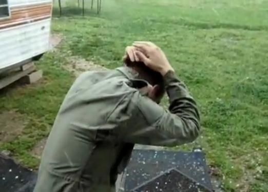
"Pelted With Hail." Check out this
YouTube clip of a barrage of hail in northwestern Georgia.
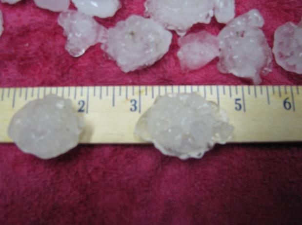
"Hailers" In Indiana. Thanks to Katherine King at
WTHR-TV in Indianapolis for posting these. More details from their web site: "
Large hail (as large as egg sized 2” in diameter fell in Lawrence), while golf-ball sized hail fell in Cumberland and New Palestine. Ping pong ball sized hail fell in Lapel, Lawrence, Greenfield, near Arlington .. and quarter sized hail in Carmel, Castleton, NE Indy, Shelbyville, among other spots. The storms fired up as very isolated cells late Sunday evening and moved out of Indiana between midnight and 1am. Here’s one picture from Lawrence – from Katherine King who posted on WTHR’s facebook page."
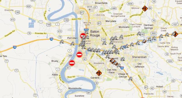
High Water In Louisiana. Many parishes are still submerged, the result of 5-10" rains in the last 1-2 weeks. Many roads around Baton Rouge are closed.
Details: "
Currently there are high water road closures in Calcasieu, Natchitoches, and Vernon Parishes. For more information visit www.511la.org and sign up at www.twitter.com/L A D O T D Emergency."
Warm Weather, Dearth Of Snow Leave Ski Resorts Scrambling To Keep Terrain, Chairlifts Open. The story from
realaspen.com: "
Flowers are blooming along the sidewalks. Snow on the mountains is melting fast. Residents here aren't sure whether to ski or golf. But most of them are certain of one thing: Climate change is not a hoax. The Aspen Skiing Co., the mayor, a pair of county commissioners and many residents in town are pressuring the Aspen Chamber Resort Association to quit paying dues and divorce itself from the U.S. Chamber, which has aggressively lobbied against climate legislation over the years. The 680-member local chamber wrote a letter to the national group in 2010 delineating its political differences, but the debate this ski season — the driest one here since 1976-1977 — has become far more heated."
Photo credit above: "
A skier navigates Corkscrew run on the bottom part of Aspen Mountain last weekend. The run has since closed. Photo by Troy Hooper."
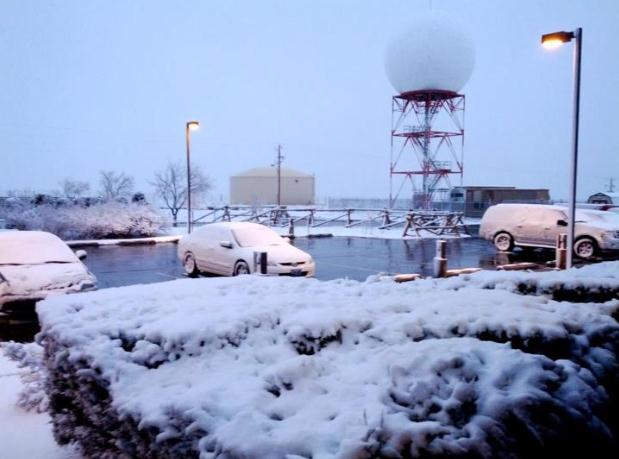
What Spring? Check out the view out the front door of the Riverton, Wyoming National Weather Service Office. Details from their
Facebook site: "
As of 6 AM 2.4 inches of snow has fallen here at the office, while only a trace has fallen in downtown Riverton (it remained rain overnight). What a difference about 500 feet in elevation can make!"
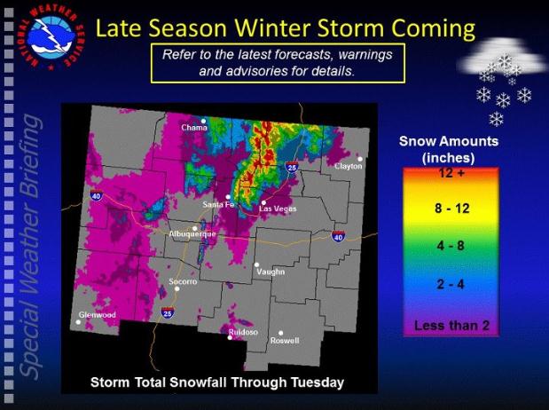
Significant Snow For New Mexico. Here is more information from the
Albuquerque, New Mexico office of the National Weather Service: "
A late season winter storm will develop over Northern New Mexico today. Here is a graphic of the snow amounts we’re anticipating."
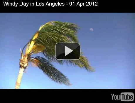
Windy Outlook For L.A. What I'd give to have a palm tree in my yard. Maybe 30 years from now at the rate we're going? Here's a
YouTube clip showing high winds in Los Angeles on Sunday.
The 2012 Hurricane Season Is Coming: What You Need To Know.
Redorbit.com meteorologist Joshua Kelly has some highlights, tips, and changes to the NHC hurricane classification scale this year: "
As we look at the calendar and see that winter is behind us for another year here in the Northern Hemisphere and the severe weather season is upon us, that can mean only one thing – hurricane season is on its way and now is the time to prepare yourself and get ready. The National Hurricane Center in Miami, Florida has adjusted the winds for tropical weather this year to be as follows. The changes will impact these three CATS:"
- Cat 3 will be winds from 111-129 mph.
- Cat 4 will be 130-156 mph.
- Cat 5 will not be anything 157 mph and greater.
* photo credit: NASA.
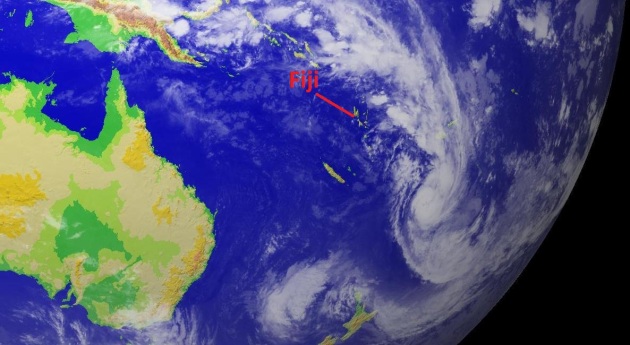
Fiji Faces Chaos As Cyclone Threatens To Worsen Flooding. An update on historic flooding on the Pacific island of Fiji from one of my favorite publications,
Bloomberg BusinessWeek: "
Fiji, an island chain in the South Pacific, is battling heavy flooding that’s caused fatalities and may be exacerbated by a tropical cyclone that formed today. “There are thousands of people in evacuation shelters, many of whom had to leave their homes quickly,” the government said in a statement on its website today. “Combined with the fact that electricity is out in many areas, inhibiting communications, this all leads to confusion. Debris exists below the surface and currents are very strong.” Tropical Cyclone Daphne was about 550 kilometers (342 miles) west-southwest of Nadi at 1 p.m. local time, moving southeast at about 35 kilometers an hour, according to a Fiji Meteorological Service bulletin issued at 4 p.m. today. An alert is in effect for all of Fiji, with severe flood warnings in force for all major rivers, streams and low lying areas of Viti Levu, the service said."
* Pacific satellite image courtesy of "
DigitalCyclone".
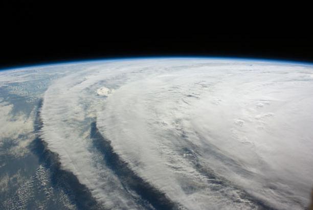
"Ask Paul". Weather-related Q&A.
Hi Paul,
"I was just curious as to what causes a cloud pattern such as this. I'm a pilot and thought it would be high winds aloft but the winds around 3-6000 ft (hight of clouds) are only 20-25 kts. I'm not sure if the picture shows clearly but not only are they wavy but also have ridges."
Thanks,
Ken
Ken- your photo is a great example of "wave clouds", caused by an inversion, temperatures warming with altitude, which gives the clouds a smooth, laminar appearance. You don't necessarily need to be in the vicinity of hills or mountains to get wave clouds (although they are more common near the Rockies and western mountain ranges). It's evidence of cool air at the surface and warmer air aloft. It also looks like "cloud streets" setting up with the cloud layer about 10,000 feet above the ground. Great shot!
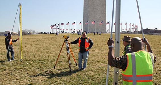
Surveying On The National Mall: Did The August 2011 Quake Shift The Ground Underneath The Monument? Tremors in D.C.? I'm expecting a plague of locust to show up on Doppler any moment now. The story from
NOAA: "A rare 5.8-magnitude earthquake near Washington, D.C., on August 23, 2011, shook the nation’s capital with enough force to crack stones and loosen mortar in the Washington Monument. But not all effects of the earthquake are visible to the naked eye. What if the ground underneath the Monument shifted because of the quake? Experts from NOAA’s National Geodetic Survey (NGS) are nearing completion of a leveling survey that will help answer this question. This is the first phase of a planned longer-term effort to assist the National Park Service (NPS) by regularly surveying the grounds of the National Mall.
Photo credit above: "
Surveyors prepare to take height measurements near the Washington Monument. From left to right, Clyde Dean, cartographic technician; Davey Crockett, geodetic technician; Jeff Olsen, geodesist; and Eric Duvall, geodetic technician."
Swiss-Army Inspired Modular Camping Box Turns Your Car Into A Small RV. Because I want nothing more than to turn my car into an RV. That said, this is pretty cool - details from the amazing techo-geeks over at
gizmag.com: "
The problem with campers is that you need a good tow vehicle with hitch to travel with them. If you have a smaller, less powerful car or lack a hitch, you'll need to spend money on a better car or hitch installation before you can even consider a camper. The Swiss Roombox levels the playing field, allowing even small car owners to enjoy many of the conveniences of a camping trailer. The device is a removable set of modules that turns the average car into a mini-motor home."
This Kid Can Dance! I had to include this - one of the funnier (cuter) things I've seen online lately. Nearly 9 million hits for 2-year old William Stokkebroe. Why do I think he's going to wind up on "Dancing With The Stars" (if the show survives, that is. Check out the
YouTube clip: "
The boys name is William Stokkebroe. After seeing his parents Kristina and Peter Stokkebroe and the dancers of studie43 practising he is showing what he has learned at the Galla opening 2. Marts 2012."
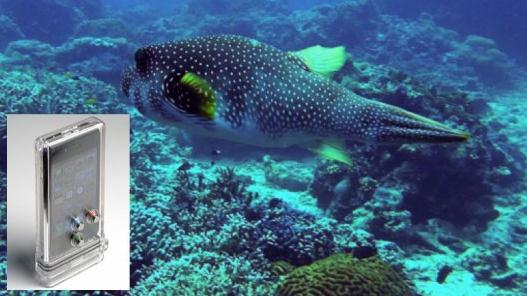
"TAT7" Case Keeps Your iPhone Clicking Underwater. If you spend a lot of time near (or in) the water and you don't want to part with your precious iPhone, even for a moment, check out the details from
gizmag.com: "
There was a time, back in the days of film cameras, when the only ways of getting underwater photos were to buy an expensive waterproof SLR, an expensive waterproof housing for a regular SLR, or a cheap disposable waterproof camera that took horrible shots. Now, all you have to do is buy a housing like the TAT7 iPhone Scuba Case, and start snapping high-res pics – assuming you’ve got the phone to go with it."
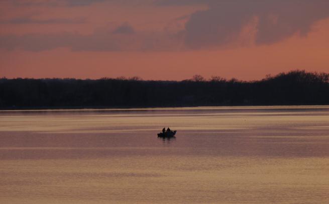
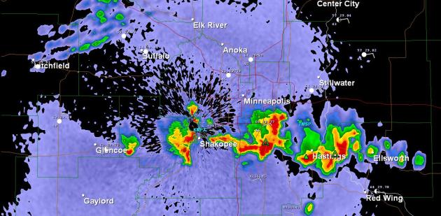 First T-storms Of Spring
. This was last night's NWS Doppler radar image at 11:25 pm, showing an east-west line of storms over the south metro. GR2 Analyst estimated 1/2 to 1" diameter hail with a few of the storms near Hastings.
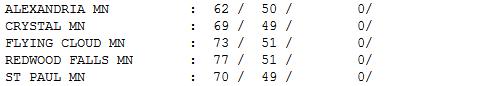 Another Day - Another 70
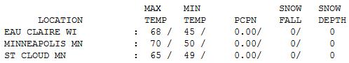
. Much of Minnesota broke out into the "warm sector" ahead of a cool front; enough sun for a high of 70 at MSP International Airport and St. Paul, 73 Eden Prairie and 77 at Redwood Falls. St. Cloud saw more cloudiness, with a respectable high of 65. T-storms (first of the season) popped up over the metro area around 11 pm last night as the cool front approached.
 Paul's Conservation Minnesota Outlook for the Twin Cities and all of Minnesota:
TODAY: Damp, gray start. Slow clearing, cool breeze. Winds: NE 10-20. High: 61 (50s greater Minnesota)
TUESDAY NIGHT: Clear to partly cloudy - brisk. Low: 42
WEDNESDAY: Partly sunny, above average temperatures. High: 62
THURSDAY: Mix of clouds and sun. Still dry. Low: 40. High: 59
FRIDAY: Fading sun, breezy. Low: 41. High: near 60
SATURDAY: Showers likely. Have a "Plan B" (wetter day of the weekend). Low: 46. High: 58
SUNDAY: Partly sunny, breezy. Drier day - but cool. Low: 45. High: 57
MONDAY: Bright sun. Frost late at night? Low: 38. high: 55
* Good chance of frost next Tuesday and Wednesday morning - possibly as far south as the Twin Cities suburbs. We slowly warm back up again toward the end of next week.
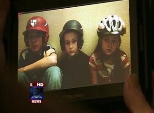
Tornado Helmets?
In the movie "Twister" an F5 tornado was called the "finger of God". I don't think any of us can imagine what 200 mph sustained winds for 2-3 minutes must be like; a horrific blender of debris, capable of scraping homes down to foundation.
May 22, 2011: Joplin, Missouri. One of six 2011 EF-5 tornadoes strikes (with 24 minutes warning). 161 people die instantly; another 1150 people injured. A mile-wide tornado roars through the city of 50,000 people.
"The tornado was leveling 1,000 homes, injuring 100 people, killing 10 every single minute" said veteran tornado chaser Jeff Pietrowski, who came up on a scene of indescribable carnage. He put his camera down, dug survivors out of rubble, setting up a triage center. Cell phones were useless; it would take hours for help to arrive. He told me something I'm sharing with you: "When a tornado warning is issued everyone should be wearing HELMETS; football, hockey, bike helmets, doesn't matter." Most tornado injuries are from blunt head trauma. It may look goofy, but it may just save your life.
Nothing severe in sight; no big storms either - highs near 60 this week.
Keep a light jacket handy; a light frost is possible next week.
* photo above courtesy of
myfoxatlanta, which has an excellent story on using helmets during tornadic storms
here.
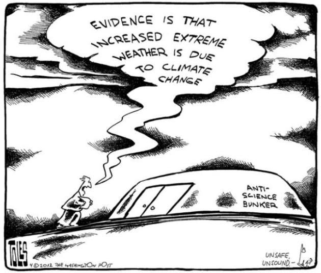
Climate Stories...
Thanks to
Tom Toles at The Washington Post for this one...
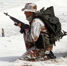
U.S. Military Forges Ahead With Plans To Combat Climate Change. Wait, now the military is in on this vast liberal conspiracy? Wow. Who knew. Thank God someone in The Pentagon has some common sense and still sees a place for science. Here's an excerpt from an article at The Daily Climate and
Scientific American: "
The U.S. military's elite forces have always pushed the envelope. And this summer will be no exception, as the Navy deploys SEALs with $2 million of new gear on missions to save hostages, combat pirates, and counter terrorism around the world. What sort of next-generation weaponry, armor, or transportation will the funds provide? None. The cash will pay for solar technology, enabling the SEALs to power up equipment and purify water while on the move, and even refrigerate medical supplies and food. "It's really the first step in the Navy's effort to make the SEALs net-zero energy and net-zero water (use) down the road," said Thomas Hicks, the Navy's Deputy Assistant Secretary for Energy."
Photo credit above: "
Image: Wikimedia Commons/Harald Hansen."
Climate Change Deniers Don't Want Us To Connect The Dots On Extreme Weather. The story from
The Huffington Post: "
I've just had a fascinating up close and personal experience of the right-wing climate denial echo chamber in action. It all started with an ABC Australia report on Thursday, by a journalist who apparently thought he had a scoop in publishing information from a purportedly secret document produced by the Global Campaign for Climate Action (GCCA). The GCCA is an alliance of NGOs for which I serve as the Executive Director. The document in question was a resource for communicating to public audiences the scientific conclusions of the latest IPCC report on the link between climate change and extreme weather. The report shows that climate change has already, or will in the future increase the frequency and severity of many kinds of extreme weather (strange that THAT wasn't the headline news). The fact that the document was published on our website and had been distributed to hundreds of people apparently escaped him."
Do Temperature Records Reliably Show The Planet Is Warming? Here's an excerpt of a story at the
The Guardian: "
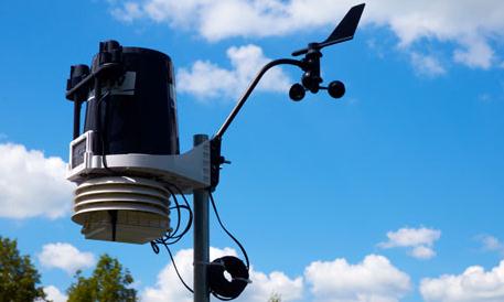
Global temperature records are crucial to scientific assessment of climate change, so many steps are taken to ensure that the records are reliable and that any factors which could cause biases are accounted for. One example is "urban heat islands" – the phenomenon of temperatures in cities being higher than those in rural locations. To make sure records from cities don't skew the bigger picture, estimates of global warming either omit urban stations or compensate for them by incorporating adjustments based on differences between temperatures at urban and rural sites. Air temperatures are also screened against other air temperatures from nearby locations to detect erroneous values, false trends and jumps which are then corrected or removed."
Photo credit above: "
A weather station that records rainfall, temperatures, wind speed and direction. Photograph: Alamy."
Science And The Doubting Conservatives. Here's an excerpt from a
Los Angeles Times article: "
With so many scientific issues becoming battlefields in the culture wars — from climate change to stem-cell research to evolution (see above) — we hardly needed a new study to tell us that scientists have become a favorite target of the right. Yet a paper written by University of North Carolina doctoral fellow Gordon Gauchat and published last week in the American Sociological Review also contains a highly counterintuitive finding. Common sense, as well as past research, suggests that distrust of science correlates with lack of education; the less education a person has, the more likely he or she will favor traditional beliefs or religious dogma over scientific evidence. There's even an academic name for this theory: the "deficit model" of scientific literacy. When it comes to modern conservatives, however, the deficit model does not apply."
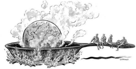
Cartoon credit above: "
Analyzing results from the General Social Survey, which has been conducted by the University of Chicago's National Opinion Research Center since 1972, University of North Carolina doctoral fellow Gordon Gauchat found that for conservatives with college degrees, trust in science declined more over time than it did for conservatives with only a high school degree. (David Gothard / For The Times / March 30, 2012)."
A Tour Of The New Geopolitics of Global Warming. An excerpt from
Scientific American: "
Energy security and climate change present massive threats to global security, military planners say, with connections and consequences spanning the world. Some scientists have linked the Arab Spring uprisings to high food prices caused by the failed Russian wheat crop in 2010, a result of an unparalleled heat wave. The predicted effects of climate change are also expected to hit developing nations particularly hard, raising the importance of supporting humanitarian response efforts and infrastructure improvements. Here's a look at several geopolitical hotspots that will likely bear the unpredictable and dangerous consequences of climate change and current energy policies."
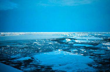
Global Warming Began In Oceans 135 Years Ago, Suggests Study. Here's an excerpt of a story from
The Christian Science Monitor: "
The world's oceans have been warming for more than 100 years, twice as long as previously believed, new research suggests. The findings could help scientists better understand the Earth's record of sea-level rise, which is partly due to the expansion of water that happens as it heats up, researchers added. "Temperature is one of the most fundamental descriptors of the physical state of the ocean," said the study's lead author,Dean Roemmich, an oceanographer at the University of California, San Diego. "Beyond simply knowing that the oceans are warming, [the results] will help us answer a few climate questions."
Photo credit: "
This undated handout photo provided by NOAA shows Arctic ice. A new study reveals that ocean surface temperatures have been increasing for twice as long as previously believed. NOAA/AP/File."
How The Big Energy Companies Plan To Turn The United States Into A Third-World Petro-State. An Op-Ed in
The Huffington Post: "
The “curse” of oil wealth is a well-known phenomenon in Third World petro-states where millions of lives are wasted in poverty and the environment is ravaged, while tiny elites rake in the energy dollars and corruption rules the land. Recently, North America has been repeatedly hailed as the planet’s twenty-first-century “new Saudi Arabia” for “tough energy” -- deep-sea oil, Canadian tar sands, and fracked oil and natural gas. But here’s a question no one considers: Will the oil curse become as familiar on this continent in the wake of a new American energy rush as it is in Africa and elsewhere? Will North America, that is, become not just the next boom continent for energy bonanzas, but a new energy Third World? Once upon a time, the giant U.S. oil companies -- Chevron, Exxon, Mobil, and Texaco -- got their start in North America, launching an oil boom that lasted a century and made the U.S. the planet’s dominant energy producer. But most of those companies have long since turned elsewhere for new sources of oil."


No comments:
Post a Comment