83 F. high in the Twin Cities yesterday.
70 F. average high for May 17
68 F. high temperature on May 17, 2011.
99 F. high yesterday in Madison, Minnesota,
96 F. at Granite Falls.
41 mph:
highest gust yesterday at KMSP.
June 3: date of the first 90-degree plus day last year (91 F).
.36" rain predicted by midday Sunday in the Twin Cities (NAM).
64.6 F. dew point predicted Saturday evening in the metro area. Translation: a serious case of the stickies.
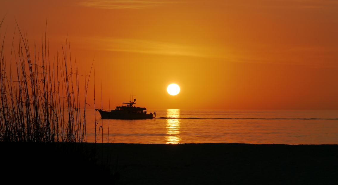 May 18, 2012
 Sunrise:
5:40 AM CDT Sunset: 8:39 PM CDT
14 hours, 57 minutes of daylight today in the Twin Cities.
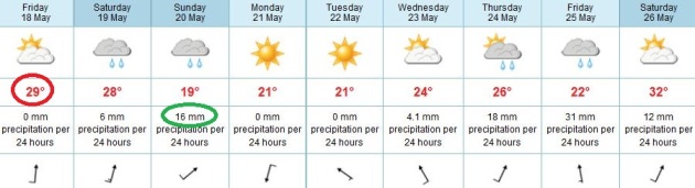 Near 90 Today - Sunday: Wettest Day
.
The weekend won't be a total loss, but have a viable Plan B for late
Saturday and Sunday, which (based on the fairly reliable ECMWF data)
appears to be the wetter day of the weekend, temperatures 10-20 degrees cooler than Saturday.
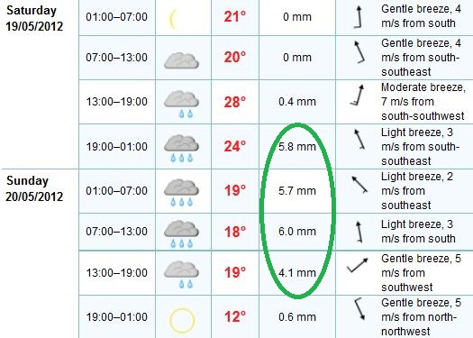 Weekend Weather Details
. Rest assured - those temperatures are in Celsius. The best chance of significant rain:
late
Saturday into mid afternoon Sunday, as a slow-moving cool front pushes
across Minnesota. Your best odds of salvaging some dry weather this
weekend? Saturday morning, and late in the day Sunday, after the dinner
hour. Data courtesy of ECMWF.
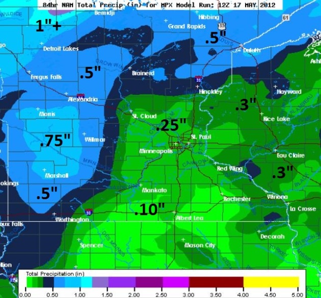 Weekend Rainfall Outlook
. The latest NAM
model predicts the heaviest rains (.5 to 1") over western and northern Minnesota.
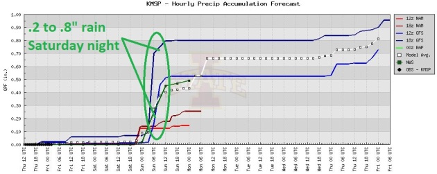 Timing The Rain
.
The models print out the most significant rain (showery rain and
embedded thunderstorms, some possibly heavy) from late Saturday into
Sunday morning. Graph: University of Iowa Meteorology Department.
"
The U.S. just experienced the hottest 12 months since the
National Weather Service began keeping records in 1895; extreme weather
events are on the rise around the globe; and the Midwestern grain belt
is overdue for a major drought." - from an article at The Fiscal Times below.
"
Six- and seven-day forecasts would be about as accurate as a
five-day forecast was a decade ago: about 430 miles on either side of a
forecast line, the hurricane center said." - from a Palm Beach Post article about longer-range forecasts on the way from The National Hurricane Center, NHC.
"
States in the upper Midwest fared worse than those in the south
part of the region, the study found, with the number of severe
rainstorms rising by 203 percent in Wisconsin, 180 percent in Michigan,
160 percent in Indiana and 104 percent in Minnesota." - from a new climate study; details in a story from Planet Ark below.
Extreme Rain Doubled In Midwest: Climate Study. No,
the rain is not falling as gently as it did for your grandparents.
Here's an excerpt from a breaking climate-news study at
Planet Ark: "
The
number of extreme rainstorms - deluges that dump 3 inches or more in a
day - doubled in the U.S. Midwest over the last half-century, causing
billions of dollars in flood damage in a trend climate advocates link
to a rise in greenhouse gas emissions. Across the Midwest the biggest
storms increased by 103 percent from 1961 through 2011, a study
released by the Rocky Mountain Climate Organization and the Natural
Resources Defense Council reported on Wednesday. States in the upper
Midwest fared worse than those in the south part of the region, the
study found, with the number of severe rainstorms rising by 203 percent
in Wisconsin, 180 percent in Michigan, 160 percent in Indiana and 104 percent in Minnesota."
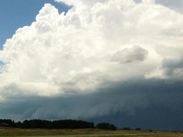
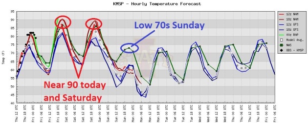 90 Possible Today and Saturday
.
Models are in pretty good alignment. Assuming the sun is out much of
today and at least the first half of tomorrow, we stand a good chance of
reaching the 90-degree barrier both days, followed by a noticeable
cool-down on Sunday. HIghs next week will be more moderate, generally in
the 70s to near 80 by the end of the week.
Australia Has Hottest 60 Years In A Millenium. The story from the U.K.
Guardian; here's an excerpt: "
The last 60 years have been the hottest in Australasia for a millennium and cannot be explained by natural causes, according to a new report by scientists that supports the case for a reduction in manmade carbon emissions.
In the first major study of its kind in the region, scientists at the
University of Melbourne used natural data from 27 climate indicators,
including tree rings, corals and ice cores to map temperature trends
over the past 1,000 years."
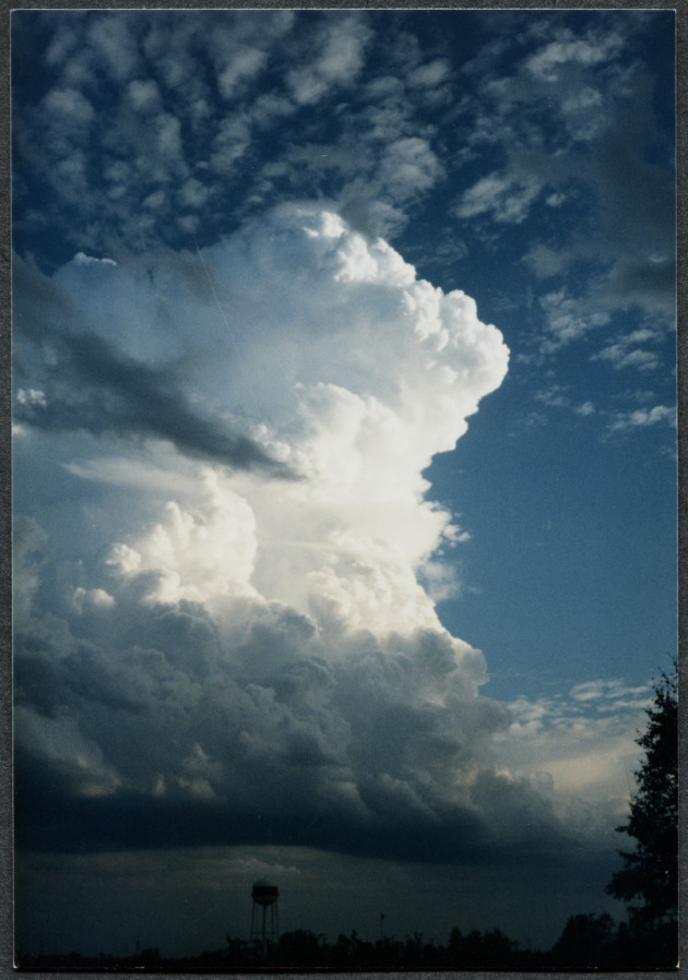
How much does a large thunderstorm cloud weigh? It must contain a lot of water. Here's a great question, and a thorough answer, from Dr. Mark Seeley's weekly
WeatherTalk blog:
Answer: "
Thomas Schlatter, a NOAA scientist and
contributor to Weatherwise magazine addressed this question in a past
issue. Of course the answer is highly dependent on cloud volume. But
consider a cumulus cloud with a volume of one cubic mile (1 mile
wide, 1 mile long, and 1 mile deep) and a water content of 1
gram/cubic meter. This would calculate to a weight of about 9 million
pounds (nearly 1.1 million gallons). That's quite a load to remain
suspended in the atmosphere, but of course it does, primarily because
of the droplet size and the updraft winds that hold these water
droplets aloft until they reach a critical mass."
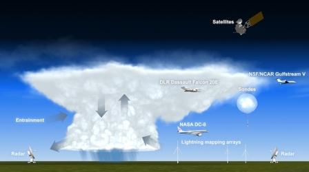
Major New Project Targets Mystery Of Thunderstorms. Here's a clip of an informative article from meteorologist Andrew Freedman at
Climate Central: "
A
multifaceted air and ground-based scientific field campaign is
underway in the Central and Southern U.S., with about 275 scientists,
pilots, and technicians out to solve meteorological mysteries about how
thunderstorms affect the chemistry of the upper atmosphere. The 45-day
field campaign, known as the Deep Convective Clouds and Chemistry Project,
or DC3, could help climate scientists fine tune their computer models
and improve simulations of global warming. The project, which involves
experts from the National Oceanic and Atmospheric Administration
(NOAA) and NASA, along with researchers from Germany and numerous
universities, employs a wide array of assets, including ground-based
research radars, sophisticated lightning mapping arrays, as well as
three heavily-modified research aircraft that will help measure changes
in atmospheric chemistry before, during, and after thunderstorms move
through a particular region."
Graphic credit above: "
Diagram of the field campaign's research platforms gathering data on a thunderstorm. Click on image for a larger version." Credit: NCAR.
Experts To Test Earlier Hurricane Forecasts. Details from
The Palm Beach Post; here's an excerpt: "
Buoyed
by the increasing accuracy of its three- and five-day forecasts, the
National Hurricane Center will test six- and seven-day forecasts this
storm season. Those forecasts, however, won't be made public anytime
soon. And Gov. Rick Scott says he hopes forecasts of any length won't
matter for Florida this year. "I hope we continue the plan of not
having any hurricanes," Scott told Wednesday's opening session of the
Florida Governor's Hurricane Conference. No hurricanes have made
landfall in the state in six storm seasons. The six- and seven-day
forecasts would pick up on work the hurricane center started last year.
It stopped because of budget cuts - and because some forecasts were
leaked to the public before they were ready."
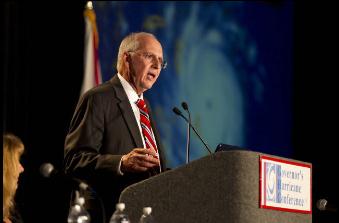
Hurricane Center Recalls Monster "Andrew". Here's a snippet from a story at
The Miami Herald:
"In
this age of smart phones, Twitter and a 24/7 news media, every
tropical wave rolling off faraway Africa is almost as closely monitored
as a Kardashian sister shopping on South Beach. Things were a lot
different 20 hurricane seasons ago, when a weak little system named
Andrew meandered toward the Bahamas, not getting a whole lot of
attention until it morphed overnight into a Category 5 killer, one of
the strongest storms on record. South Florida had just two days of high
alert to hunker down for what would become one of the costliest
natural disasters in United States history, a catastrophe that exposed
gaping holes in emergency planning."
Photo credit above: "
Max Mayfield gives some first hand
accounts of his experiance during Hurricane Andrew to an audience of
weather experts and emergency managers as they look back at how
Hurricane Andrew changed what they do. The 20th anniversary of the big
one is a main topic at the annual governor's hurricane conference in
Lauderdale. C.W. Griffin / Miami Herald Staff."
Read more here: http://www.miamiherald.com/2012/05/16/2803087/hurricane-summit-recalls-monster.html#storylink=cpy
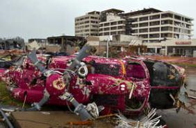
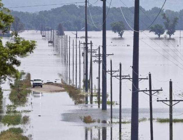
Storms Of 2011 Among Most Costly Storms Ever, Insurers Report.
KansasCity.com has the story; here's an excerpt: "
Last
spring’s storms — including deadly tornadoes in Joplin, Mo., and
Tuscaloosa, Ala. — ranked among the most damaging events to property in
U.S. history, an insurance industry report said Wednesday.
Collectively, 2011’s tornadoes, hail and winds inflicted $21.3 billion
in insured property damage in a few months, the report from the New
York-based Insurance Industry Institute said. The total ranks fourth,
behind the $24 billion associated with the Sept. 11 terrorist attacks
in 2001, the $25 billion in losses from Hurricane Andrew in 1992 and
the $47.6 billion in damage from Hurricane Katrina in 2005."
Photo credit above: "
The medical helicopter at St. John's
Hospital was tossed into the in the parking lot after a tornado on May
22, 2011, swept through the center of Joplin, Mo., causing widespread
damage."
Minnesota Off-Road Cyclist Weather Blog. Kudos to WeatherNation TV meteorologist Kristin Clark for launching a
new blog, marring two of her passions: mountain biking and meteorology. Here's a snippet: "
The
science behind riding a bicycle is not very well understood. At first
this might seem odd or even trivial but consider this: scientists
understand airplanes better than bicycles! A bike is an extremely
complex object. It would take 30 pages of equations to describe just
how mass, geometry, inertia, etc. interact together on a bike. You
would think after 200 years we would have this figured out. Well, one
such scientist (and bike enthusiast) is determined to get to the bottom of it."
What Is The Business Model For "New Media"? An interesting read from
techzone360.com; here's an excerpt: "
Media,
whether old or new, social or linear, has become a complicated matter.
Google insists that it is a technology company, even if its business
model is based on advertising, this typically is the case for most
media. Facebook is a social network, yet gets in excess of 80 percent of
its revenue from advertising. Facebook also serves as a way people
discover interesting content, and a way people create content. Amazon
is a retailer, but much of its retailing success hinges on the content
its users supply, and a growing part of what Amazon sells are content
products. Facebook may look and function like a social network for the
majority of its users, but on the business side it looks almost exactly
like a traditional media company."
Read more here: http://www.kansascity.com/2012/05/16/3614631/storms-a-year-ago-among-most-costly.html#storylink=cpy
Read more here: http://www.kansascity.com/2012/05/16/3614631/storms-a-year-ago-among-most-costly.html#storylink=cpy
The $19K "Quadrofoil": Ecologically Sound Sportscar For The Water. I expect one of these to show up any day now on area lakes;
gizmag.com has the details: "
Due
to the remarkable efficiency of hydrofoils, it achieves its 25 mph
top speed with just one 3.7 kW electric motor, and thanks to its
lightweight (150 kg - 330 lb) carbon fiber and Kevlar body and in-built
4.5 kWh lithium batteries, it has a range of 100km (62 miles). It can
also be recharged from a domestic powerpoint in an hour, or via the
flexible solar panels which come with each Quadrofoil and are designed
to be folded inside the watercraft as an emergency power source, or to
top up the battery when "off the grid."
Sony Puts A Phone Display On Your Wrist. Paging Dick Tracy - your watch/computer has arrived. More from the New York Times's Gadgetwise: "
You
know how people who rudely check their phones every 42 seconds can
drive you completely bonkers? Thanks to Sony they won’t do that any
longer. Instead they will drive you bonkers by checking their watches.
Sony’s SmartWatch
links with a phone to show text messages, e-mails, photos and updates
from your social networks on its face. The watch can also be used to hit
redial and control other functions, like the smartphone’s music player.
Oh — it also tells time." Photo courtesy of Sony, which has more information on the SmartWatch
here.
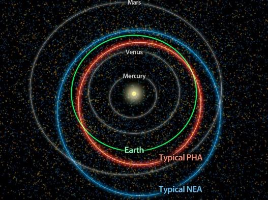
Tracking Potential Hazardous Asteroids. Here's
another fascinating article about new technology helping astronomers
track asteroids that could strike the Earth. Yep, don't sweat the
thundershowers.
Gizmag.com reports: "
Potentially
hazardous asteroids (PHAs) are a subset of near-Earth asteroids
(NEAs) that have the potential to come within five million miles
(eight million kilometers) of Earth, and are of a size large enough to
make it through Earth’s atmosphere to cause significant damage on a
regional, or greater, scale. NASA’s asteroid-hunting NEOWISE mission
has now provided the best estimate yet of the number of PHAs in our
solar system, along with their origins and the potential dangers they
might pose. While all NEAs have an orbit that brings them within close
proximity to Earth, only some of them have orbits that intersect with
Earth’s and are of a large enough size to be classified as PHAs."
Illustration credit above: "
Diagram showing the
differences between orbits of a typical near-Earth asteroid (blue) and a
potentially hazardous asteroid, or PHA (orange) (Image:
NASA/JPL-Caltech)."
I'd Like A "Roast Beef And Finger Sandwich" Please.
Read this story and try not to gag. Hey accidents happen, but this one
just makes you shake your head. Ah, the perils of fast food. This
cautionary tale is brought to you by AP and
The Washington Post: "
JACKSON,
Mich. — A Michigan teen finishing off an Arby’s roast beef sandwich
chomped down on something tough that tasted like rubber, so he spit it
out. Turns out it tasted like finger. The fleshy, severed pad of an
unfortunate employee’s finger, apparently. Ryan Hart, 14, told the
Jackson Citizen Patriot on Wednesday that once he got a good look at
it, he knew right away what had been in the junior roast beef sandwich
he was eating last Friday. “I was like, ‘That (has) to be a finger,’”
Hart said. “I was about to puke. ... It was just nasty.”
Photo credit above:
Jackson Citizen Patriot, Danielle Salisbury/Associated Press. "Ryan
Hart, poses for a photo in Jackson, Mich. Hart, 14, found a piece of
finger in his Arby’s sandwich. Jackson police and the county health
department say an Arby’s employee cut her finger on a meat slicer.
Health officials believe the employee then left her station, and other
workers continued to fill orders before they became aware of what
happened."
A 4 Inch Screen For The iPhone 5? Calling rumor central. Here is more speculation about the next iteration of the iPhone, from those amazing techno-geeks at
gizmag.com: "
Apple
is expected to unveil the next iPhone at its annual mobile keynote
this year and as is the case with any high profile product launch,
rumors about the device are beginning to materialize months before the
event is scheduled to take place. Most recently, Wall Street Journal
sources suggest that Apple intends to upsize the iPhone’s display from
3.5 to 4 inches. The information comes from sources "familiar with the
matter" who appear to have connections at screen manufacturers Sharp
and LG. While this is far from official information, if true, it could
mean that Apple is finally feeling the pressure from competitors like
Samsung, whose 4.8-inch Galaxy SIII is one the most anticipated
devices of the year."
Welcome to Canada! Image courtesy of
Facebook.
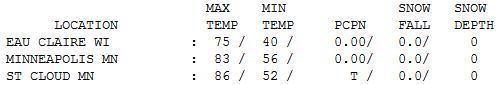
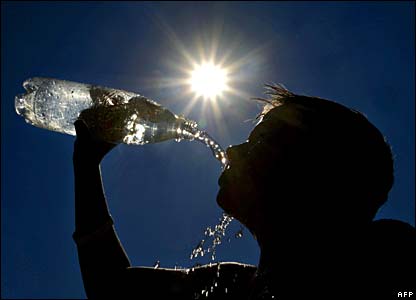
 Warming Up
.
Yesterday was only the appetizer - the main course (of heat and
humidity) comes later today and tomorrow. In spite of clouds lingering
into mid afternoon highs reached 86 at St. Cloud, 83 in the Twin Cities,
91 at Alexandria and 92 at Redwood Falls.
Paul's Conservation Minnesota Outlook for the Twin Cities and all of Minnesota:
TODAY: Hot sun, gusty winds. Winds: S 15-30. High: 89
FRIDAY NIGHT: Warm and sultry - very humid. Low: 67
SATURDAY: Morning sun, T-storms possible late. Winds: S 15-30. High: near 90
SATURDAY NIGHT: Heavy showers and T-storms. Low: 61
SUNDAY: Cooler, still damp with heavy showers, T-storms. Winds: N 10-20. High: 75
SUNDAY NIGHT: Gradual clearing. Low: 53
MONDAY: Could have guessed this: sunny and beautiful! High: 75
TUESDAY: Sunny and warmer. Low: 56. High: 79
WEDNESDAY: Partly sunny. Late T-storms possible far west. Low: 59. High: near 80
THURSDAY: Showers, few heavy T-storms. Low: 60. High: 77
Relative Risk
"Anyone who has spent a few nights in a tent
during a storm can tell you: The world doesn't care all that much if you
live or die" wrote Anthony Doerr.
If you're heading out to enjoy Minnesota's
10,000 plus lakes take a radio, or a few storm apps on your smart phone.
Riding out a severe storm in your car or truck is probably safer than
huddling in a tent with 90 mph winds shrieking overhead.
That said - the odds are in your favor. Out of
100 thunderstorms fewer than 10 will become severe; less than 1 will
ever go on to spawn a tornado.
A new research study shows the number of 3 inch
downpours hitting Minnesota has doubled since 1961; a 203% spike for
Wisconsin. The rain is not falling as gently as it did for your
grandparents. Welcome to Weather 2.0. Details on the weather blog.
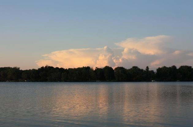
A "hot front" lures the mercury near 90 today,
again Saturday - probably the hottest weather of 2012, to date. The
dreaded dew point may reach mid 60s tomorrow, a good excuses to take a
dip in the nearest lake. Strong storms rumble in late Saturday. The
European (ECMWF) solution keeps heavy rain around much of Sunday, as
temperature drop into the 70s.
Monday looks perfect. No surprise there.
Climate Stories....
Weather-Related Disasters On The Rise. Here's a story from
The Fiscal Times: "
If
you don’t have enough to worry about with the stock market sagging and
the economy in the doldrums, ponder these facts: The U.S. just
experienced the hottest 12 months since the National Weather Service
began keeping records in 1895; extreme weather events are on the rise
around the globe; and the Midwestern grain belt is overdue for a major
drought. This isn’t a story about climate change or a subtle
advertisement for hybrid vehicles.
Global warming wasn’t even a concept during the 1930s dust bowl, the
rain-scarce late 1950s or the major droughts that hit the U.S. plains in
1980 and 1988."
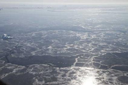
Arctic Death Spiral: More Bad News About Sea Ice. The trends are alarming for the Arctic region;
Climate Central brings us up to date: "
The sea ice that blankets the Arctic Ocean each winter peaked in early March this year, as usual, and is now in retreat,
en route to its annual minimum extent in September. How low it will go
is something scientists worry: ice reflects lots of sunlight back into
space, and when the darker ocean underneath is exposed, more sunlight
is absorbed to add to global warming. That’s the simple version of the
story, but things look even worse when you dig into the details. For
one thing, all that open water does re-freeze each winter, but it
freezes into a relatively thin layer known as seasonal, or first-year
ice. Because it’s so thin, first-year ice tends to melt back quickly
the following season, giving the ocean a chance to warm things up even
more in what National Snow and Ice Data Center director Mark Serreze has called a “death spiral” that could lead to ice-free Arctic summers by 2030."
Photo credit above: "
The sun reflects over thin sea ice and a few floating icebergs." Credit: Jefferson Beck/NASA
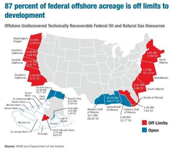
What The Oil Industry Wants - In Charts. Here's an excerpt from a
Washington Post article: "
In many ways, life has never been better for the U.S. oil and gas industries. Production is up,
thanks to new fracking technology. Profits are high. There’s little
chance Congress will cap carbon emissions anytime soon. What more could
they ask for? Quite a bit, it turns out. On Tuesday, the American
Petroleum Institute released a report
full of recommendations to the Republican and Democratic committees
that are crafting their party platforms this summer. Basically, this is
Big Oil’s wish list. It includes everything from opening up more
federal lands for drilling to avoiding strict new federal rules on
natural-gas fracking. And API has also included a slew of charts that help give a better sense for what’s driving the oil and gas industry."
A Bright Future For Renewable Energy. Here's a clip from an article at
The Huffington Post: "
The
current market for the renewable energy sector in the United States
and around the world is a mix of challenge and opportunity. However,
the long-term future of clean energy is bright. According to our recent
report, "Who's Winning the Clean Energy Race? 2011 Edition,"
last year saw record private investments globally. And the United
States received more investments for clean energy than any other nation.
These investments resulted in record deployment levels -- 83.5 gig
watts of clean generating capacity overall, including an unprecedented
30 gig watts of solar. But like other emerging high-technology
industries before it, the clean-energy sector is going through a period
of profound transition. The industry faces powerful financial and
policy cross currents."
Only Biofuels Will Cut Plane Emissions. The story from
The Guardian: "
As
a small, maritime trading nation Britain has always been some distance
from big international markets. Our ability to visit far-off places
and people, and their access to us, has always been at the heart of our
ability to punch above our weight in the world, whether that's
commercially, culturally or diplomatically. In the past we were
dependent on ships, now we are reliant on commercial airlines, as well
as the Channel Tunnel and secure data networks. This infrastructure is
critical for our future, particularly as we look to major economies like
India, China and Brazil for export opportunities. But it is also vital
for sustaining our outward facing society and culture; one that's
confident engaging with the world and welcoming of its diversity."
Photo credit above: "
A plane taking off from Newcastle airport." Photograph: Owen Humphreys/AP
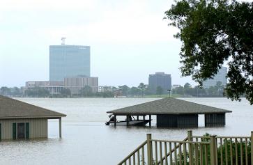
Corporations Are Tackling The Risks Associated With Climate Change. Here's an excerpt from
thomasnet.com: "
Companies
are accustomed to managing risks such as legal liabilities,
accidents, natural disasters, credit and finance risks and security
threats. But what about risk arising from climate change, such as its
potential effect on production and business operations, regulatory and
litigation risks or reputational risks? Processes and policies around
climate risk — the risk profile of a company’s exposure to climate
change — are still evolving, but companies are addressing climate
change in ways that cross over between traditional risk management and
corporate sustainability efforts."
Photo credit above: "
Post-hurricane flooding in Lake Charles, La. Credit: Chuck Simmins, CC BY 2.0."
Himalayas Warming Faster, Facing Severe Climate Change Impact: Study. Details from
The Times of India: "
NEW
DELHI: A scientific study published on Wednesday revealed that the
Himalayas, one of world's richest biodiversity zones, is warming faster
than other parts of the globe. The research, conducted by
Boston-based University of Massachusetts and Bangalore-based Ashoka
Trust for Research in Ecology and Environment (ATREE) points that the
average mean temperature during a 25-year period (1982-2006) in the Himalayas
has increased by 1.50 degree Celsius. The researchers claimed that the
rise in temperature in the Himalayas is three times greater than the
increase in global average of temperature during the same period." Photo above: NASA.
Margaret Thatcher, Others: Neither "Murderers, Tyrants , Nor Madmen". The Heartland billboard (fiasco) continues to reverberate; here's a post from
The Yale Forum on Climate Change and the Environment: "
This
month’s “This Is Not Cool” Yale Forum video explores a phrase
popularized — or more likely made infamous — by the recent Heartland
Institute Chicago highway poster featuring Unabomber Ted Kaczynski:
“murderers, tyrants, and madmen.” In a word-association game, it’s
unlikely that many would bring up the names of Margaret Thatcher, or of
Columbia University’s Wallace Broecker. Nor, for that matter, those
of NASA scientist James Hansen; of the late biochemist and novelist
Isaac Asimov; of theoretical physicist, author and cosmologist Stephen
Hawking; of the late Cornell University astrophysicist and author
Carl Sagan; of Microsoft’s Bill Gates; of Navy Admiral David Titley;
or of Nobel Laureate, and now Secretary of Energy, Steven Chu."


This comment has been removed by the author.
ReplyDelete