74 F. high in the Twin Cities yesterday.
69 F. average high for May 15 in the metro area.
64 F. high temperature on May 15, 2011. Source:
NOAA.
12.6 mph: average wind speed yesterday in the cities.
31 mph: peak wind gust at KMSP.
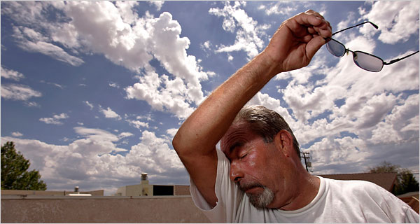
90 F. possible Friday in the Twin Cities, possibly the first 90, and the warmest day of 2012 so far.

"
Spring has returned. The Earth is like a child that knows poems." - Rainer Maria Rilke
"
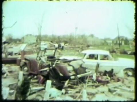
The last time researchers saw a storm like that was May 6th,
1965 when twisters swept across the metro. Thirteen people died,
hundreds were left injured. Blumenfeld says research shows storms like
that happen every 40 to 50 years. "We really haven't had one like that
in over 50 years almost. It means it's probably going to happen sooner
rather than later," he said."- from a KARE 11 special pondering the probabilities of a major tornado hitting the Twin Cities; details below.
"
As one of its major goals within the 10 years, the hurricane
center hopes to generate six- and seven-day forecasts to give
residents, businesses and the military more time to
prepare....Currently, the center issues track forecasts out to five
days, with an average error of about 275 miles." - from a story at staugustine.com; details below.
"
From February through April, pollen was at record high levels.
This coincided with one of the driest and warmest winters on record." - from a story at NJ.com - details below the 7-Day.
"Scientists say climate change might also
be adding an extra kick to La Nina and El Nino because warmer oceans
add more fuel to storms and weather patterns." - from a Reuters article below.
“
Critics are our friends, they show us our faults.”
-
Benjamin Franklin
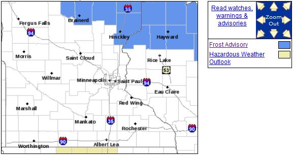
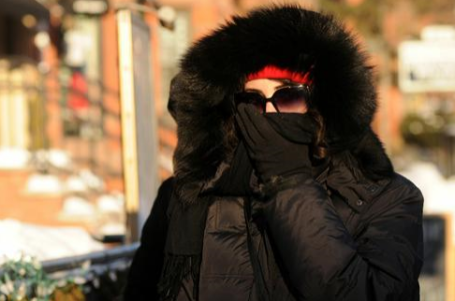
Frosty Relapse. A Frost Advisory is posted early this morning as close to the metro as Hinckley and Hayward - a little close for comfort.
Details from the Twin Cities office of The National Weather Service:
...FROST ADVISORY IN EFFECT FROM 2 AM TO 8 AM CDT WEDNESDAY...

THE NATIONAL WEATHER SERVICE IN DULUTH HAS ISSUED A FROST
ADVISORY...WHICH IS IN EFFECT FROM 2 AM TO 8 AM CDT WEDNESDAY.

* LOCATION...AREAS OF FROST ARE EXPECTED ACROSS MOST OF THE
  NORTHLAND...EXCEPT ALONG THE LAKE SUPERIOR SHORELINE AND SAINT
  LOUIS BAY.

* TEMPERATURE...LOWS TONIGHT WILL RANGE FROM 33 TO 38 ACROSS THE
  TWIN PORTS...THE BRAINERD LAKES REGION AND MOST OF NORTHWEST
  WISCONSIN.

* IMPACTS...FROST WILL DAMAGE AND MAY KILL SENSITIVE OUTDOOR
  PLANTS.
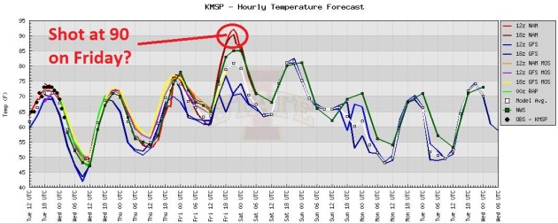 Frost on a Wednesday - 90 on a Friday
.
Don't like the weather? Stick around a few minutes; it'll change. A few
models are hinting at 90 in the metro Friday. If the sun stays out much
of the day we should see upper 80s, possibly 90 - in all probability
the warmest day of 2012 so far.
Storm-Ready. Is The Twin Cities Prepared For A Major Tornado?
The short answer is no, but I'm glad KARE 11 is running this series,
trying to break through a wall of apathy and skepticism. "Tornadoes
always hit somewhere else....we never get hit....stop hyping the weather
and interrupting my favorite TV show!" We get this a lot. One of these
days an EF-4 is going to hit the suburbs, or even the downtowns, and the
results could be catastrophic. More from
KARE-11: "
GOLDEN
VALLEY, Minn. - The images of tornadoes twisting and turning, leaving
devastation in their wake can be jaw-dropping. From semi-trailers tossed
like toys in Dallas, Texas earlier this year, to total destruction in
Joplin, Missouri last year. That is why KARE 11 teamed up with Minnesota Public Radio News to find out if the Twin Cities is storm ready. Our meteorologists Belinda Jensen and MPR's Paul Huttner put together a simulation of a major tornado hitting Minneapolis."
"The reality is if you put a large tornado over a populated area,
people are going to get hurt," said Ken Blumenfeld, University of
Minnesota geography professor and tornado researcher.
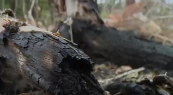
Pagami Creek Wildfire Burn Zone Showing Signs Of New Life.
Drought conditions are worst over far northern Minnesota, just about
the only part of Minnesota that didn't see heavy rain 10 days ago.
WDIO.com in Duluth reports on growing concerns about the Pagami Creek blaze rekindling: "
Images
of burning trees and billowing smoke had most of us in awe, as the
Pagami Creek Wildfire ravaged the Boundary Waters Canoe Area Wilderness
last fall. It took just a matter of hours for the small, monitored fire
to grow out of control. But now, with the fire out, you can see the
damage up close, and the first signs of a healing forest. The damage is
everywhere. Black, charred bark covers weak and often toppled trees.
Those that still stand look nothing like they used to. Needles used to
cover red and jack pine, and birch trees were wrapped with white bark.
But it's all destroyed now."
First Tropical Storm of 2012: "Aletta". A threat to
ships and slow-moving whales, T.S. Aletta is pushing west, out into the
colder waters of the Pacific Ocean, where it should slowly weaken - no
threat to land. More from
NASA's Facebook site: "
The
eastern Pacific hurricane season starts today. Just slightly ahead of
schedule tropical storm Aletta formed yesterday well to the southwest
of the Mexican coast. Aletta will intensify a little more to 40 knots.
After tomorrow, adverse atmospheric conditions will prompt weakening
and dissipation as the cyclone continues to move just north of west.
Max winds are near 35 knots, it is centered near 10.6 North and 109.6
West."
* image above: Naval Research Lab.
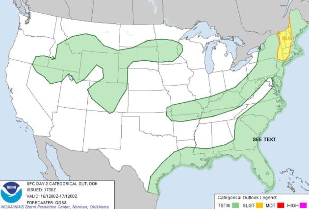 Wednesday Severe Threat
.
An eastbound cool front may spark enough convergence for a few severe
storms from Albany to Worcester, Burlington and Montpelier, Vermont.
Map: SPC.
 A "Plan B Weekend?"
 It's
still early and the forecast may change (for the better), but we've had
a few days/row of fairly gloomy model outlooks. A slow-moving cool
front may spark heavy showers and T-storms from the PM hours Saturday
into the first half of Sunday; models hinting at some 1 to 1.5" rainfall
amounts.
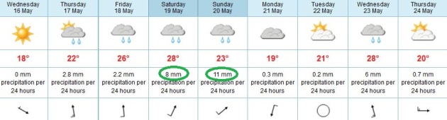 Another Sloppy Nail In The Weekend Coffin
.
I don't think we'll see a steady rain, or an all-day washout.
Precipitation should be convective, showery, with embedded heavy showers
and T-storms late Saturday into a portion of Sunday. The latest ECMWF
model predicts 19 mm. of rain Saturday and Sunday, about .75" rain.
"Hammock Weather." Thanks, I needed this.
WeatherNation TV meteorologist Bryan Karrick was kind enough to navigate
his iPhone and send in this photo from his favorite hammock out in
Cologne yesterday. Go easy Bryan.
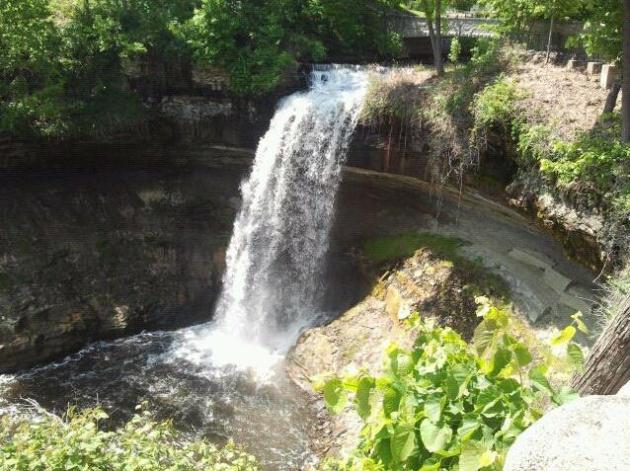
Minnehaha Falls. Thanks to Siah C. for showing us a reassuring amount of water coming over the falls as of May 15, 2012.
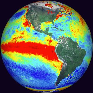
Why Do El Nino And La Nina Trigger Weather Chaos? Reuters has an informative article; here's an excerpt: "
From
record floods to crippling droughts and wildfires, a natural swing in
Pacific Ocean temperatures can trigger climate chaos around the globe. The El Nino ocean-weather pattern is linked to droughts in Australia
and floods in parts of South America, while its sibling La Nina causes
the opposite, with the two phenomena occurring at irregular intervals.
A powerful La Nina triggered record floods in eastern Australia in
2011 and has been blamed for the withering drought in Texas and severe
dry spells in South America, hitting corn and soy crops."
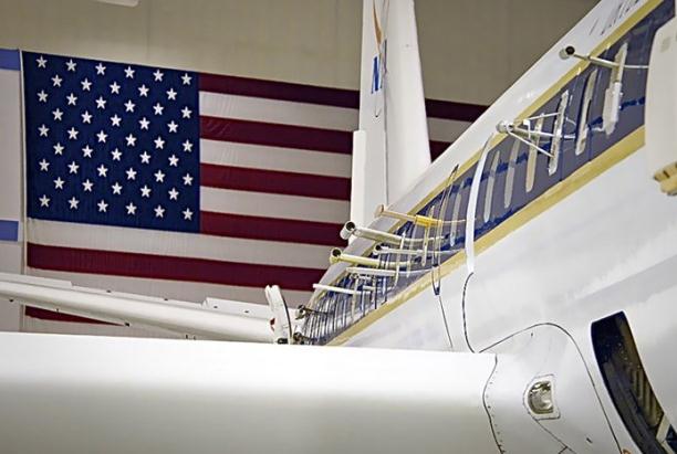
DC3: Chemistry of Thunderstorms. Flying planes into
thunderstorms to gather more data? I suspect drinks are not served on
these flights; here's an excerpt of an eye-opening article at
redorbit.com: "
NASA
researchers are about to fly off on a campaign that will take them into
the heart of thunderstorm country. The Deep Convective Clouds and
Chemistry (DC3) field campaign will use an airport in Salina, Kan., as a
base to explore the impact of large thunderstorms on the concentration
of ozone and other substances in the upper troposphere. The campaign is
being led by the National Center for Atmospheric Research in Boulder,
Colorado, and is funded by the National Science Foundation (NSF) and
NASA. “Thunderstorms provide a mechanism for rapid lifting of air from
the surface to higher altitudes in a matter of minutes to hours,” said
James Crawford of NASA’s Langley Research Center in Hampton, Va., and a
member of the mission’s scientific steering committee."
Photo credit above: "
NASA's DC-8 Earth Science laboratory
sports numerous probes for collecting atmospheric samples. The aircraft,
based at the Dryden Aircraft Operations Facility in Palmdale, Calif.,
is ready to participate in the DC3 campaign. Credit: NASA/Tom Tschida."
NASA researchers are about to fly off on a campaign that will take them into the heart of thunderstorm country.
The Deep Convective Clouds and Chemistry (DC3) field campaign will
use an airport in Salina, Kan., as a base to explore the impact of large
thunderstorms on the concentration of ozone and other substances in
the upper troposphere. The campaign is being led by the National Center
for Atmospheric Research in Boulder, Colorado, and is funded by the
National Science Foundation (NSF) and NASA.
“Thunderstorms provide a mechanism for rapid lifting of air from the
surface to higher altitudes in a matter of minutes to hours,” said
James Crawford of NASA’s Langley Research Center in Hampton, Va., and a
member of the mission’s scientific steering committee.
“This allows molecules that are short-lived and more abundant near
the surface to be transported to the upper troposphere in amounts that
could not happen under normal atmospheric conditions,” he said.
Hurricane Center To Develop 6 And 7 Day Forecasts. Details from
staugustine.com: "
FORT
LAUDERDALE — For the first time, the National Hurricane Center plans
to develop six- and seven-day track forecasts for an entire storm
season. It also plans to do a better job keeping them secret, as they
leaked out to the public last year, cutting the experiment short. “We
weren’t able to button them up; people were finding them,” said James
Franklin, the center’s top hurricane specialist. The long-range
forecasts are one of four in-house experiments the hurricane center
plans to conduct in the upcoming season, which officially starts June 1."
Hurricane Center Testing Forecast Improvements. Here's another perspective from
The Boston Herald: "
MIAMI
-- The National Hurricane Center plans to broaden its forecasting
capabilities by conducting four in-house experiments in the upcoming
season, including developing six- and seven-day track projections. The
other tests include extending the tropical weather outlook from two to
five days, developing advisories for disturbances before they become
tropical systems and issuing watches and warnings if disturbances
threaten land. At the same time, it will employ more sophisticated
models to help with intensity predictions, an area where forecasters
have struggled for decades."
"Lessons From Hurricane Ike Prompts Action". The story (and video clip) from
phys.org: "
As
teachers go, Hurricane Ike isn't likely to win any popularity
contests. But the 2008 storm, the third-costliest hurricane in U.S.
history, taught severe-storm experts much about how to protect Houston
and Galveston from the ravages of future storms. In the new book
"Lessons from Hurricane Ike," Rice University severe-storm expert Phil
Bedient and more than 20 researchers from the Severe Storm Prediction,
Education and Evacuation from Disasters (SSPEED) Center give a 194-page
accounting of all they have learned in more than two years of studying
Ike, which caused nearly $25 billion damage and killed dozens."
U.S. Government, Wireless Carriers, Launch Weather Emergency Alerts This Month.
Text alerts should be part of your family's severe weather action plan,
along with TV, radio, web, e-mail, NOAA Weather Radio (and sirens).
Details from
mobileburn.com: "
The
U.S. Government and wireless carriers in the States are set to launch
the Wireless Emergency Alert (WEA) system this month. The WEA is a free
service that uses text message alerts to inform cellular phone users
of nearby weather emergencies. The alerts will warn users of weather
emergencies and dangerous weather conditions such as tornadoes,
hurricanes, floods, typhoons, blizzards, dust storms, extremely high
winds, and ice storms. The system is location based, so users will only
get alerts that apply to where they are currently located. The WEA
system is supported by AT&T, Cellcom, Cricket, Sprint Nextel,
T-Mobile, U.S. Cellular, and Verizon Wireless, which combined offer
cellular service to about 97 percent of the users in the United States."
Exposure To Natural Cold and Heat: Hypothermia and Hyperthermia Medicare Claims, 2004-2005. With a rapidly aging population, more baby boomers moving into their "golden years", I found this research paper at
medscape.com interesting. Here's an excerpt: "
Older
adults (≥ 65 years) and persons with chronic diseases are at risk for
heat- and coldrelated mortality and morbidity during extreme ambient
temperatures. Even slight changes in temperature can adversely affect
these populations because of their weakened physiological adaptability
and socioeconomic factors. As the growing evidence of global climate
change supports anticipated increases in the intensity and frequency of
heat waves and extreme cold events, older adults and those with
chronic diseases will be at an increased risk for hyperthermia and
hypothermia. The US Census Bureau projects that the number of older
adults will rapidly increase during the 2010 to 2030 period.
Accordingly, it is projected that by 2030, the older population will be 2
times greater than in 2000, growing from 35 million to 72 million, or
nearly 20% of the total US population."
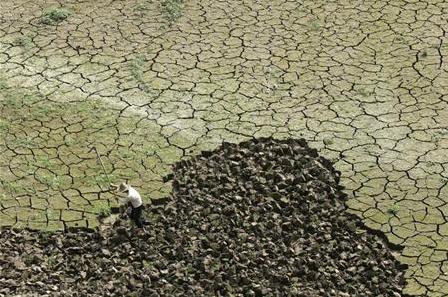
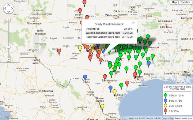
Data App: Track Texas Reservoir Levels. Although the
drought has eased a bit over parts of Texas, water levels are still
very low, especially from the Hill Country into the Texas Panhandle.
The Texas Tribune has details of a new online resource for tracking reservoir water levels: "
The most intense drought in Texas history lowered reservoir levels around the state, stirring widespread concern about water shortages.
By April 2012 many had bounced back, particularly in Central and East
Texas, after those areas saw an unusually rainy spring. But many West
Texas levels remain very low. Using data collected from the Texas Water
Development Board's reservoir status tracker,
we have built a tool that visualizes the current levels of the state's
reservoirs. The map will be updated daily with fresh data. Each icon
on the map represents an individual reservoir, color-coded based on how
full it is currently."
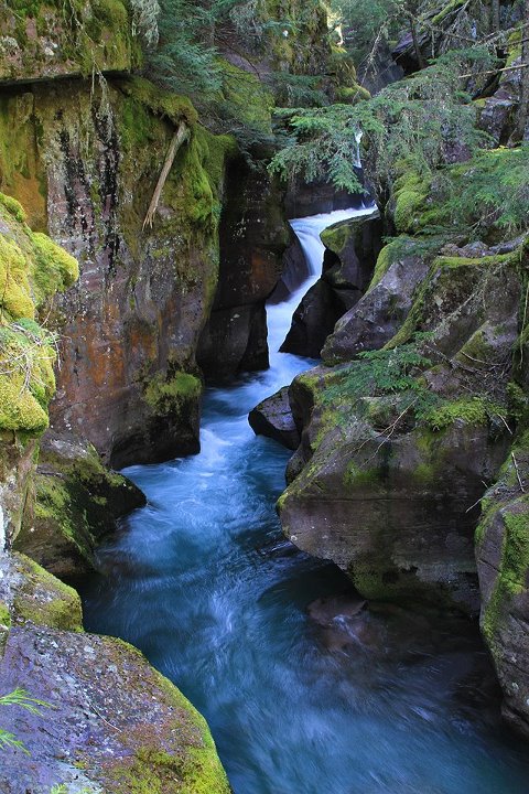
Postcard-Perfect. Here's a post from Glacier National Park, brought to you by
Mark Zuckerberg. Hey, is Facebook going public? Here's a hot tip: buy low, sell high. Good luck. "
It
is turning out to be another spectacular day in Glacier, and Avalanche
Gorge never looked so good. At this location on the Trail of the
Cedars, you can witness the power of water. From its sculpting and
erosional action, to the nourishment it provides to plants and animals,
and the emotional impact it has on us, water is very significant here."
World's Most Expensive Camera Sells At Auction For $2.77 Million. Some people have more money than sense, as reported by
gizmag.com: "
The
Viennese WestLicht Photographica Auction House continued its stellar
run of success with its 21st Camera auction in just its eleventh year
as an auction house, when it recently broke its own world record for the
fifth consecutive time by selling one of the original Leica 0-series
cameras for €2,160,000 (US$2.77 million), including the buyer’s premium."
Get Rich U. Author Ken Auletta writes "there are no
walls between Stanford and Silicon Valley. Should there be? Here is an
excerpt of a thought-provoking article at
The New Yorker:
"Stanford University is so startlingly paradisial, so fragrant and
sunny, it’s as if you could eat from the trees and live happily
forever. Students ride their bikes through manicured quads, past
blooming flowers and statues by Rodin, to buildings named for
benefactors like Gates, Hewlett, and Packard. Everyone seems happy,
though there is a well-known phenomenon called the “Stanford duck
syndrome”: students seem cheerful, but all the while they are furiously
paddling their legs to stay afloat. What they are generally paddling
toward are careers of the sort that could get their names on those
buildings. The campus has its jocks, stoners, and poets, but what it is
famous for are budding entrepreneurs, engineers, and computer aces
hoping to make their fortune in one crevasse or another of Silicon
Valley.
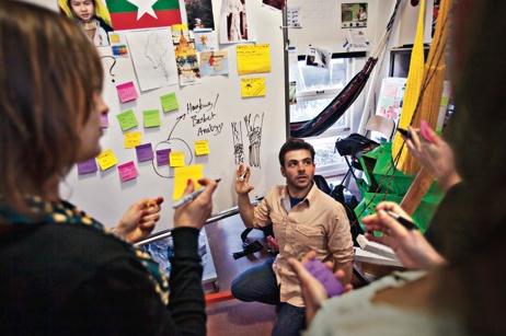
Photo credit above: "Students
at the Institute of Design at Stanford, or d.school, work this spring
on an irrigation project for farmers in Burma. The work is part of the
university’s focus on interdisciplinary education. Photograph by Aaron
Huey."
"Sturgeon Weather".
Thanks to Joe Buckley, for sending in this shot from Ottertaill Lake
in western MN. He caught this 25 lb. sturgeon. Well done!
Read more about sturgeon HERE.
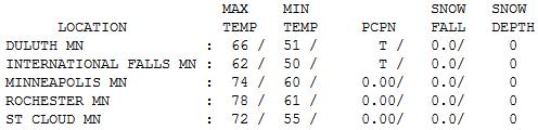
Free A/C.
It felt pretty good out there yesterday, cool, clean, Canadian exhaust
on the backside of a fast-moving clipper (that went on to spark severe
T-storms near Chicago Tuesday evening). With a mix of clouds and sun and
a fresh northwest wind at 10-20 mph, with higher gusts, Tuesday highs
ranged from 62 at International Falls to 66 at Duluth, 72 at St. Cloud,
74 in the Twin Cities and 78 at Rochester.
Words To Live By. Better yet, avoid camels altogether.
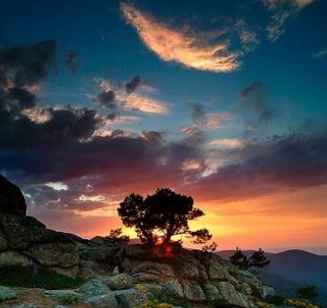
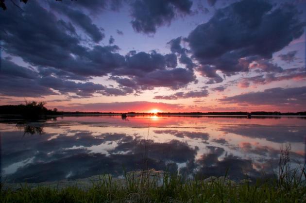
Postcard-Worthy Sunset. Thanks to Steve Burns who lives in Lino Lakes for one of the best photos I've seen in recent weeks. What a weather pattern...
Paul's Conservation Minnesota Outlook for the Twin Cities and all of Minnesota
TODAY: Sunny and perfect. Low humidity. Winds: S 5-10. High: 74
WEDNESDAY NIGHT: Clouds increase - chance of a T-storm late. Low: 56
THURSDAY: More clouds and humidity, few T-storms (best chance north of the metro area). High: 80
FRIDAY: Hot, steamy sun. First 90 of 2012? Winds: S 10-20. Low: 64. High: near 90
SATURDAY: Sunny, hazy and humid start, heavy PM T-storms. Low: 65. Winds: S 10-20. High: 84
SUNDAY: Heavy showers and T-storms. Some 1-2" rain possible. Winds: W 10 Low: 61. High: 72
MONDAY: Sun returns (naturally). Dry sky. Low: 53. High: 74
TUESDAY: Sunny and pleasant; low humidity. Low: 56. High: 76
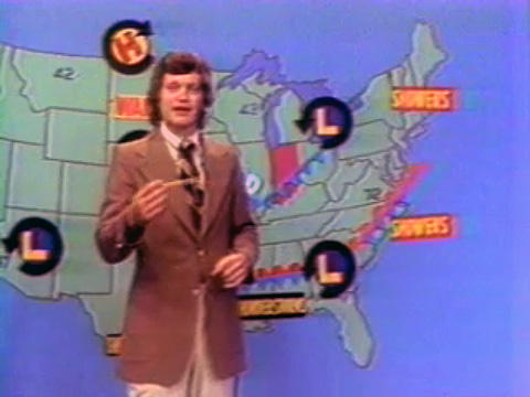
Weather Personalities
It was David Letterman who coined the phrase
"hail the size of canned hams" while doing TV weather in Indianapolis
back in the 70s. Pat Sajak and ABC News legend Diane Sawyer also got
their start pointing to a (green) weather map.
Visitors touring our studios are always
surprised by the spontaneity, the ad-libbing that goes on. "Where are
the Teleprompters?" The reality: meteorologists wing it. They study the
maps, arm themselves with a few factoids, and then make it up as they
go.
I used to remind Don Shelby that a trained monkey could be taught to "read the news". No comment.
Today will be another atmospheric daydream, the day you were wishing for back in February.
A surge of sticky, 80-degree air may set off a
few Thursday storms (best chance north of the metro). Highs surge near
90 Friday, 80s on Saturday - a summerlike dew point near 65 F. Yes,
neighbors will be whining about the humidity within 48 hours.
A cool front surging east may spark 1-2" rain
late Saturday Sunday. We can't rule out a few strong/severe storms late
Saturday. Stay alert. Your best odds salvaging warm, dry,
sunglasses-worthy weekend weather? First half of Saturday.
I'm just the messenger.
*
Letterman Photo above courtesy of MNN, Mother Nature Network, which has an
excellent article on other "personalities" and stars who started out in weather.
"
The activist is not the man who says the river is dirty. The activist is the man who cleans up the river." - Ross Perot
Climate Stories...
 As Global Warming Advances, Risky Responses Gain A Following
.
Here's an important article focused on geo-engineering, using
technology to slow or reverse the effects of global warming. Good idea?
What could possibly go wrong? Here's an excerpt from
MinnPost.com: "
A British chemical engineer, Peter Davidson, presented a webinar
early this morning on his strategy to combat global warming: Fog
Earth’s upper atmosphere with paint particles, streamed from giant
balloons, to reflect sunlight away from Earth and offset the greenhouse
effects of burning fossil fuel. Plan B, indeed. As
the years roll by with essentially no meaningful progress on cutting
carbon emissions, “geo-engineering” solutions like Davidson’s attract
more attention and perhaps even faith from those inclined to believe
that since technology got us into this mess, technology can somehow get
us out."
Photo credit above: Columbia Scientific Balloon Facility. "
A new paper proposes using large balloons to scatter sunlight and slow global warming."
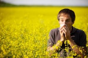
Climate Change Is Making Allergies Worse.
NJ.com has the story; here's an excerpt: "
Spring
is in full swing and swung into New Jersey earlier than ever this
year. Extreme weather events and drastic changes in weather patterns
are becoming a common occurrence. The effects of climate disruption on
human health already are afflicting allergy and asthma sufferers along
the East Coast and throughout the continental United States. May is
“Asthma Awareness Month” and this spring’s pollen levels are making
history. Unseasonably warm temperatures affect both air quality and
pollen levels."
Photo credit above: "
Photo courtesy of the American Academy of Allergy, Asthma and ImmunologyAirborne ragweed pollen is pictured in this file photo."
 Global Warming To Affect Fish Guts.
Oh no - not fish guts! There may be aquatic winners and losers as lake,
river and ocean water temperatures continue to rise, as reported in
this excerpt of a story at New Zealand's 3news.com:
Global Warming To Affect Fish Guts.
Oh no - not fish guts! There may be aquatic winners and losers as lake,
river and ocean water temperatures continue to rise, as reported in
this excerpt of a story at New Zealand's 3news.com: "
Global warming may cause some stocks of fish species
to decline, while others may grow. The gastrointestinal system of fish
is much more sensitive to rises in sea temperatures than previously
thought, according to new research. The researchers found that the gut in fish is the most temperature-sensitive organ. "Our
work is largely about trying to identify the physiological bottlenecks,
in other words which parts of the body will fail first - whether the
heart or the gut is the most sensitive part of the system," said study
researcher Albin Gräns, of the University of Gothenburg, in a statement."
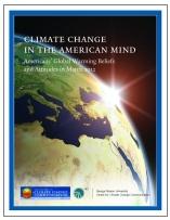 Climate Change In The American Mind: March, 2012. Here's an excerpt from some recent polling conducted by The National Center For Science Education:
 "...
Asked about the cause of global warming, on the assumption that it is
happening, 46% of respondents said that global warming is caused mostly
by human activities — a slight decrease — while 37% said that it is
caused mostly by natural changes in the environment, 9% volunteered that
it is caused by both human activities and natural changes, 5% opted for
"none of the above because global warming isn't happening," 2% offered
other views, and 1% volunteered that they did not know."
Oil And Gas Industry Moving Aggressively To Silence Critics. Here's an excerpt from a story at
The Huffington Post: "
At an industry public relations conference last year, Michael Kehs of Chesapeake Energy described a Wall Street Journal op-ed
to gathered oil and gas officials, saying it pointed out the industry's
"credibility problem." “And I’m sure some of it relates to
defensiveness,” Kehs added. (MP3 Audio) Small wonder. For years, the oil and gas industry has adopted a war-like mentality
towards its critics. When confronted with problems caused by drilling
and fracking, instead of acknowledging them and working to prevent
more, their approach has too often been to cover up the issues while
attacking any critics who make problems known publicly. This pattern has
sharply accelerated in recent months."
New Push To Limit "Super Greenhouse" Gases. Meteorologist Andrew Freedman from
Climate Central has the story; here's an excerpt: "
United
Nations climate change talks may be on a slow train to nowhere, but
that doesn't mean countries can't try tackling global warming at the
international level. Friday, the Federated States of Micronesia, a
Pacific island nation, submitted a plan
to amend the 1989 Montreal Protocol on Substances That Deplete the
Ozone Layer to phase down the production and use of so-called
"super-greenhouse gases." The Micronesian proposal, which has garnered
the support of more than 100 parties to the ozone treaty, including the
U.S. and the European Union, seeks to cut emissions of
hydrofluorocarbons, or HFCs, which are compounds that contain carbon,
hydrogen, and fluorine. These substances are used as solvents,
refrigerants, firefighting agents, and propellants. They were
introduced as a substitute for the chloroflourocarbons, or CFCs, that
scientists discovered were destroying the Earth's protective ozone
layer — thereby allowing greater amounts of the Sun's harmful
ultraviolet rays to reach the Earth's surface."
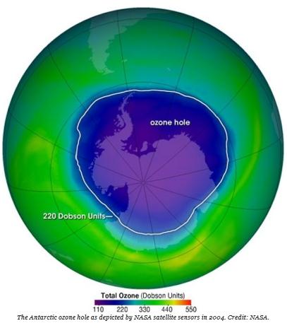
Photo credit above: "
The Antarctic ozone hole as depicted by NASA satellite sensors in 2004. Credit: NASA."
Wind-Generated Energy Is Working Well For Us In Iowa. Here's an excerpt of a letter to the editor of the
Wall Street Journal from Iowa Governor Branstad: "
Your recent editorials on the federal wind-energy Production Tax Credit (PTC) and renewable portfolio standard (RPS) ("Gouged by the Wind," May 5 and "Windy Republicans,"
May 7) are off the mark. The wind-power industry is an American
success story that is helping us build our manufacturing base, create
jobs, lower energy costs and strengthen our energy security. As a
country, we should support energy diversity and development of all
domestic resources, creating an "all of the above" energy strategy. To
that end, our state and national energy plans have long relied on
varying policies and incentives, such as the PTC and RPS, to deploy
technologies that ensure a diverse domestic energy fleet.Iowa has long
played a leadership role in developing wind power—a clean, domestic,
affordable resource. During my first term as governor, I signed the
first RPS in the country, and it continues to drive billions in private
investment in Iowa, as well as helping electric consumers."
Americans Would Pay More For Clean Energy. Would Congress? Here's a snippet from
The Washington Post: "
Would Americans be willing to pay more for cleaner electricity? A new study
finds that they would — $162 a year extra, on average. But there’s a
catch: This “willingness to pay” isn’t evenly spread across the country,
which may explain why Congress isn’t eager to pass a clean-electricity
bill. Last year, a trio of researchers from Yale and Harvard conducted
a national survey asking Americans a very simple question: Would they
be interested in a law that required utilities to get 80 percent of
their electricity from low-carbon sources such as wind, solar and
nuclear by 2035? Different respondents were given different
descriptions of the bill and different price tags. (After all,
low-carbon energy often costs more.) The results were recently published in Nature Climate Change. And, on average, $162 a year extra was the breaking point. That’s what Americans would pay."
Photo credit above: "
Would you pay $162 for this? (Paul Sakuma - AP)."
Hawaii's Beaches Are In Retreat, And Way Of Life May Follow. Here's an excerpt from
The New York Times: "
Little by little, Hawaii’s iconic beaches
are disappearing. Most beaches on the state’s three largest
islands are eroding, and the erosion is likely to accelerate as sea
levels rise, the United States Geological Survey is reporting. Though
average erosion rates are relatively low — perhaps a few inches per
year — they range up to several feet per year and are highly variable
from island to island and within each island, agency scientists say.
The report says that over the last century, about 9 percent of the
sandy coast on the islands of Hawaii, Oahu and Maui has vanished.
That’s almost 14 miles of beach."
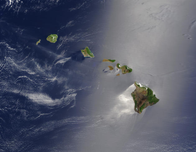
Photo credit above: Hawaii from space courtesy of
universetoday.com.
Inhofe Staffer Asks Oil Lobbyist "Partners" For "Better Coordination and Communication". Think Progress has the story: "
Republicans are the default choice for oil and gas dollars, having received 88 percent
of the industry’s political contributions in 2011. In return, House
and Senate Republicans block regulations the industry deems a potential
threat. In an April 23 e-mail acquired by National Journal,
a staffer for Sen. James Inhofe (R-OK) called on the industry to
utilize their partnership to coordinate attacks on the White House:
Senate Republicans, who led a successful fight this spring against
Obama’s proposal to repeal billions of dollars in tax subsidies enjoyed
by major oil companies, felt betrayed by the industry’s collaboration
with the White House on fracking regulations."
Earth's Environment Getting Worse, Not Better, Ahead of Rio+ 20. The Guardian has the story - here's a clip: "
Twenty years on from the Rio Earth summit, the environment of the planet is getting worse not better, according to a report from WWF. Swelling population,
mass migration to cities, increasing energy use and soaring carbon
dioxide emissions mean humanity is putting a greater squeeze on the
planet's resources then ever before. Particularly hard hit is the
diversity of animals and plants, upon which many natural resources such
as clean water are based. "The Rio+20 conference next month is an
opportunity for the world to get serious about the need for development
to become sustainable. Our report indicates that we haven't yet done
that since the last Rio summit," said David Nussbaum, WWF-UK chief
executive."
Running From Climate Change May Trip Up Some Species, Study Says. Here's an excerpt from
The Boston Herald: "
As
climate change transforms their habitat, some animals are already on
the move. But a new analysis from the University of Washington warns
that many species won’t be able to run fast enough to survive a warming
world. On average, about 9 percent of the Western Hemisphere’s mammals
migrate too slowly to keep pace with the rapid climate shifts expected
over the next century, says the study published Monday in the
Proceedings of the National Academy of Sciences. In some areas,
including parts of the Appalachian Mountains and the Amazon basin,
nearly 40 percent of mammals may be unable to reach safe haven in time."
Antarctic Ice Sheet Collapse Recorded In Octopus DNA. Here's a fascinating story from
Scientific American: "
Octopuses
have made themselves at home in most of the world’s oceans—from the
warmest of tropical seas to the deep, dark reaches around hydrothermal
vents. Antarctic species, such as Turquet’s octopuses (Pareledone turqueti), even live slow, quiet lives near the South Pole.
But these retiring creatures offer a rare opportunity to help
understand how this extreme part of the Earth has changed in recent
geologic times—and what climate change might bring there in the near
future."
Chance Of Bangladesh Sinking Under Rising Sea Levels. Here's an Op Ed from
The Financial Express: "
Science
as a Contact Sport; inside the battle to save Earth's climate" by
Stephen Schneider is an illuminating book by a world renowned climate
scientist and professor at the Woods Institute for the Environment at
Stanford University. In 2007, Schneider received the Nobel Peace Price
on behalf of the International Panel for Climate Change (IPCC), along
with Al Gore. His book is a recounting of his efforts over three decades
to get the US government and the rest of the world to pay attention to
climate change science. The basic question which climate science has
tried to answer is: how serious is climate change? But communicating a
scientific answer to this question has been impossible, Schneider says,
as politicians, journalists and the average person
on the street does not understand that scientific predictions and
models of climate change can only predict probabilities of particular
outcomes." Photo above:
NASA.
Climate Change Believers Split From Heartland Institute. An update from
slate.com: "
On
Friday, the libertarian, Chicago-based Heartland Institute made a
routine-sounding announcement. It would "spin off its insurance research
project effective May 31." The D.C.-based Center on Finance,
Insurance, and Real Estate would break off; its director, Eli Lehrer,
would found some new project. "We urge any individual, foundation, and
corporation with an interest in insurance and related finance issues to
contribute to Eli’s new organization once it is up and running," said
Heartland President Joseph Bast in a statement. "We look forward to
working closely with Eli in the future." Today, the spin-off -- dubbed
the R Street Institute -- sent out a statement from its spokesman, R.J.
Lehmann. Most of it was boilerplate about how the team of six
Heartland refugees would keep working on "much the same portfolio of
issues we already have been."
On Climate Change, A Need For A Realistic Plan. Here's a snippet from an Op Ed at
The Montreal Gazette: "
Despite
sustained misgivings within party and caucus ranks, the federal
Conservative government has, however reluctantly, come around to
acknowledging that human-generated greenhouse gases are a driving
factor in global climate change that is becoming increasingly evident
and undeniable. What is still lacking, however, is a comprehensive
approach to the problem and adequate information to educate the
Canadian public as to the scope of the effort required to cut those
emissions to sustainable levels, and the costs involved. These failings
were cast into sharp relief by this month’s report by the federal
commissioner of the environment and sustainability, which challenged
the government’s assurances that it has an effective climate-change
plan in place with an achievable target for greenhouse-gas reduction."


No comments:
Post a Comment