81 F. high in the Twin Cities Wednesday.
65 F. average high for May 2.
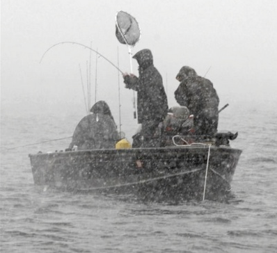
40 F. high temperature a year ago; on May 2, 2011.
80+ high temperature expected today, the last warm day in sight.
Heaviest rains forecast from Saturday PM into midday Sunday.
1.3" of additional rain predicted by Saturday night in the Twin Cities.
 79 F
79 F. Wednesday at Duluth, warmest day of the year so far.
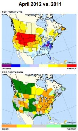
Driest April for USA Since 2001. Details from Planalytics below.
April was the 12th month in a row of warmer than average temperatures in the Twin Cities.
"Veep". My new favorite show on the boob tube. Check out the details from
HBO. Imagine Seinfeld, in The White House, where everyone is heavily medicated.
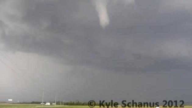
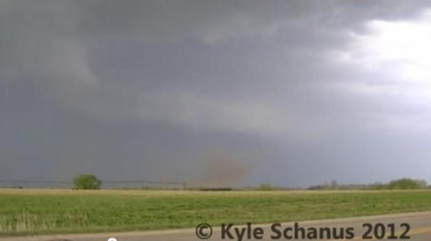
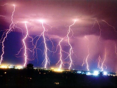
"Supercell". Thanks to Kyle Schanus for some
amazing YouTube footage
of the rotating supercell thunderstorm that spawned numerous funnels
and tornado touchdowns near Brooten Tuesday evening; reports of 2-3"
diameter hail from this cell which tracked for nearly 100 miles,
eventually weakening over the far northern suburbs of the Twin Cities.
It passed directly over St. Cloud, sparking large hail and over 3" of
rain at St. Cloud State University: "
Sped up version of rapidly rotating mesocyclone and tornado just NE of Brooten, MN."
* all damage reports (hail, high winds, funnels and tornado touchdowns) for the last 2 days can be found
here, courtesy of NOAA.
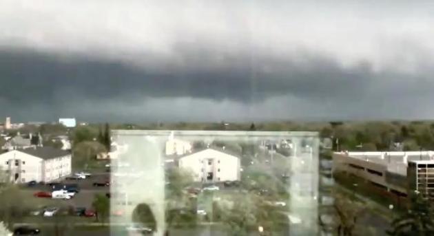
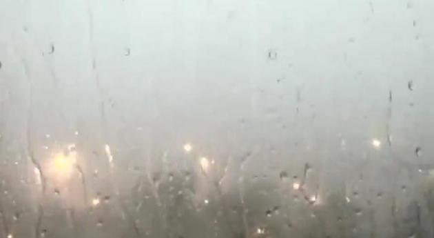
Time-Lapse of Tuesday's St. Cloud "Supercell".
Thanks to Samanta Kuffel, who set up her laptop to look out the window
and record the advancing storm (that's the reflection of her laptop in
the upper left image). The YouTube clip is
here.
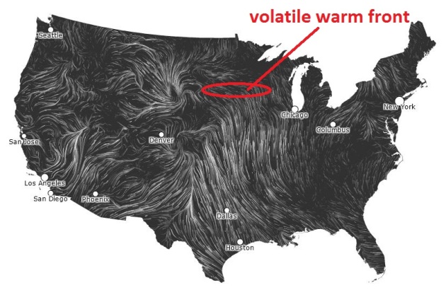
Severe Threat Shifts South. The best chance of
hail/damaging winds later today will be over far southeastern Minnesota,
shifting into Iowa by Friday as winds at the surface swing around to
the north/northwest, and both temperatures and humidity levels drop,
pushing a volatile front 200 miles south of MSP. More details from the
Twin Cities
NWS.
Convergence. 60-65 F. dew point air is surging north
across Iowa, a warm frontal boundary draped over southern Minnesota
sparking strong/severe T-storms, especially evening into the overnight
hours. Another wave of low pressure rippling east along that boundary
will spark another round of showers and T-storms late Thursday and
Friday - the best chance of severe storms over Iowa and far southeastern
Minnesota. Check out the short-term NDFD high-resolution wind forecast
for the USA
here.
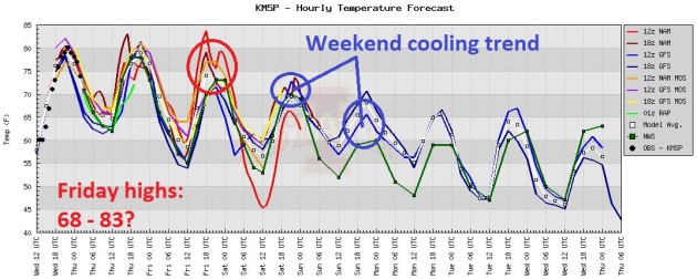
80 Today, Then Cooling Off. There's some debate
about Friday: some of the models show MSP topping 80, but the latest NAM
predicts surface winds blowing from the northeast, hinting at 60s to
near 70. If the warm front surges north we could, in fact, approach 80
(with another round of severe T-storms), but I think the odds are fairly
low. One thing that seems fairly certain: we will cool off over the
weekend with (wait for it)...more rain.
Lawn Watering Optional. Convective, showery rains
are likely later today, again Friday. The heaviest/steadiest rains may
come Saturday PM into Sunday morning as a storm tracks just south of
Minnesota. The good news: we need the rain, and a southerly track would
keep any severe storms to our south as well, as close as Iowa. The bad
news: another mostly-foul weekend is shaping up - periods of rain, highs
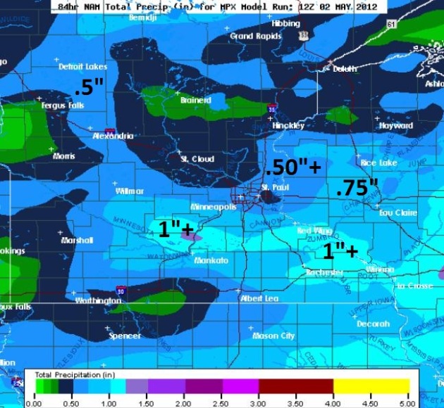
ranging from mid 50s to upper 60s. Have a Plan B. NAM model data
(above) hints at some 1"+ rainfall amounts over southern Minnesota by
Saturday night.
April Climate Summary. Details from the
Twin Cities National Weather Service office: "
After
a record breaking March, April was a more typical month for the region,
with the observed average temperatures for the month slightly above
normal. In fact, the average temperatures for the month of April were
only a couple degrees warmer at St. Cloud and the Twin Cities than they
were in March. In fact, at Eau Claire, the average temperature of 47.2
degrees for April was two tenths of a degree colder than the average
temperature for March (48.4 F)! In addition, this marks the 12th
consecutive month that the average monthly temperature for the Twin
Cities has been above normal."
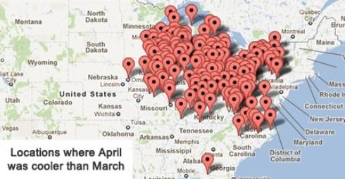
April Cooler Than March? Yep, from southeastern Minnesota to Virginia it was a "backwards spring". The Capital Weather Gang has details below.
Green Bay, Wisconsin: this past winter saw 5 feet less snow than the winter of 2010-11. Source: Jeff Last, NOAA.
Snowless winter reported at Asheville, North Carolina, for the first time since modern-day records were started in 1889-1890.
"You're 30 times more likely to die from a rip current than from a shark at the beach, according to NOAA." - from an article on rip current safety below. Photo courtesy of NOAA, which has more information on rip currents
here.
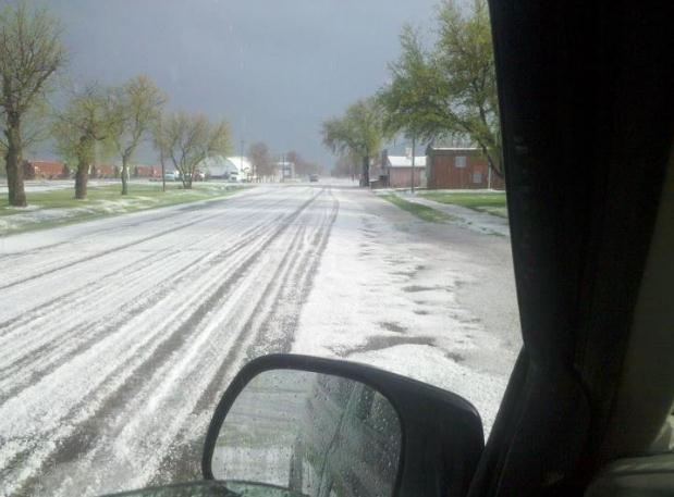
Plowable Hail Event. Check out the photo from Crystal, North Dakota, courtesy of
WDAZ-TV's Facebook site: "
Hail covering the ground in Crystal, ND, around 6:20 pm. Thanks to Tom Engelmann."
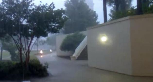
Soaking Rains For Mobile. Check out the
YouTube video clip
from weatherdudeva: "We've gotten over 5 inches of rain in just 2.5
hours from an incredible thunderstorm that's set up over Mobile, AL and
surrounding areas. At its heaviest, the rain was falling at 0.15" per
minute. This video was taken at the Mitchell Center at the University
of South Alabama. The wind was blowing the door closed, so I had to
keep the video short.
A "Backwards Spring": April Cooler Than March In Many Cities Across Northeast And Midwest. The Capital Weather Gang's Justin Grieser has the remarkable details: "
During
a typical year, monthly average temperatures move steadily upward as
spring progresses. Not so in 2012. In a stunning reversal of the
seasons, April 2012 averaged cooler than March in numerous locations
across the Midwest and Northeastern United States. An unprecedented March heat wave not only set thousands of daily high temperature records but also smashed monthly March temperature records
by such a wide margin that April had nowhere to go but down. Chicago,
Buffalo, and Washington, D.C. (at Dulles Airport) were among some of
the cities that accomplished this unusual feat. The March temperature
at Washington-Dulles International Airport averaged 54.3 degrees, but
fell slightly to 54.0 degrees in April."
Driest April For USA Since 2001. Here are a few interesting meteorological nuggets from
Planalytics:
"
While March was the warmest ever recorded in North America, April
continued to provide favorable weather for seasonal demand as well as
foot traffic. North America had its 4th warmest April in 50 years, and
warmest since 2010. Precipitation was the least since 2001. In the
U.S., April 2012 was the warmest since 2006 and driest since 2001.
Canada experienced a warmer than normal April while precipitation was
below normal.
- All 4 weeks of the month
trended drier than last year in both the U.S. and Canada. In most
instances, precipitation was also well below normal, helping
support foot traffic into shopping centers and restaurants.
- Drought conditions persisted in the
Southeast, Texas, and Southwest. Drought conditions also expanded
along the Atlantic coast.
Easter
occurred on April 8th, and was the driest in 25 years across North
America. Additionally, the run-up week to Easter was warm and dry."
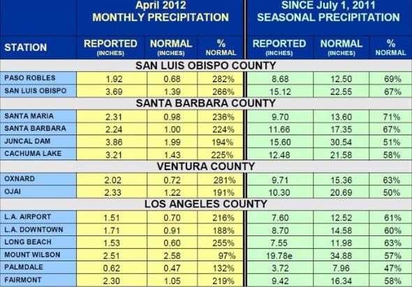
Soggy April In Los Angeles. Here's an update from the L.A. office of The National Weather Service, by way of
Mark Zuckerberg: "
We
experienced a wet April at nearly all locations within our forecast
area. In some cases it was more than 200 percent of normal! This
followed an above normal March as well. Still from a seasonal
perspective, we are well below normal for the water year which ends June
30th. Thankfully we had a wet March and April otherwise think where we
would be."
Complacency And Concern As St. Louis Faces Vulnerability To Deadly Storms. Many people, it seems, aren't taking the warnings seriously. Here's an excerpt of a story at
The New York Times: "
ST.
LOUIS — The music blared and beer flowed as dozens of people milled
around outside a downtown bar last week, celebrating another victory by
their beloved baseball champions, the Cardinals. Dark, thunderous skies
and rain did not stop the fun. But in a quick few seconds, winds
gusting at highway speeds tore a large white party tent from its
anchors and whipsawed it high onto an elevated railroad track, killing
one person, injuring more than a hundred and leaving this metropolis to
confront the fatal collision of an innocent tradition and a loathed
reality."
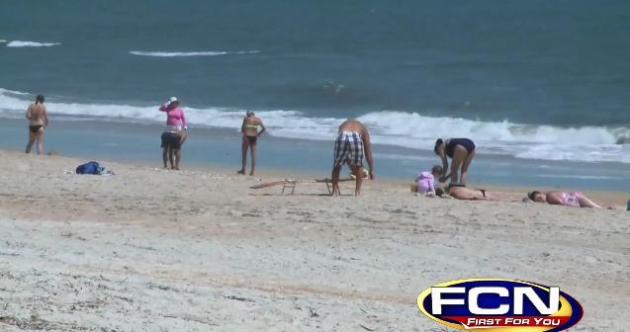
NOAA: Rip Currents Kill More Than Sharks, Tornadoes And Hurricanes. This one made me do a triple-take.
Firstcoastnews.com has more details: "
According
to the National Oceanic and Atmospheric Administration, rip currents
killed more people in Florida in the last 25 years than hurricanes and
tornadoes did combined. You're 30 times more likely to die from a rip
current than from a shark at the beach, according to NOAA. The agency
also noted that 80% of beach rescues in Florida are due to rip currents
pulling people away from the shore."
Weather Insider: What Tomorrow' Shift In The La Nina - El Nino Cycle Means.
We may be transitioning into a mild El Nino (warming) pattern later
this year. The fact that we had the 4th warmest winter on record across
the USA, in spite of a moderate La Nina (cooling) ENSO phase still blows
my mind. Here's an excerpt from
InsideClimateNews.org: "
Changes
are brewing in the equatorial Pacific, and they could profoundly
affect weather across the U.S. and much of the globe next winter and
spring. La Niña, which has held sway since last fall, will be officially
declared a goner Thursday, an official at the Climate Prediction Center
in Maryland told InsideClimate News. And while nobody is quite certain
what will happen next, some long-range forecast models are pointing to
the possible emergence of the opposite phenomenon: El Niño."
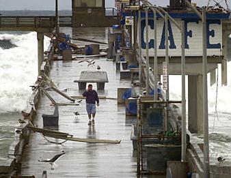
Photo credit: "
Powerful storms often pound the coast of
California in El Nino years. In December 2002, huge waves battered the
pier and damaged the cafe operated by Chuck Fisher (pictured) at San
Diego's Ocean Beach. Credit: San Diego Union-Tribune/John Gibbins."
Cool Summer, Few Hurricanes No Help To Energy Markets, MDA Says.
Bloomberg has the story; here's a clip: "
Temperatures
in the U.S. this summer will be cooler than the past two years and the
number of hurricanes coming out of the Atlantic will probably be less
than 2011, forecasters from MDA EarthSat Weather said. While June to
August may be warmer than both the 10 year and 30 year averages,
temperatures aren’t forecast to reach the record hot levels of 2011 and
2012, said Travis Hartman, energy weather manager at MDA in Gaithersburg, Maryland.
That means less energy will be needed to cool homes and businesses. “If
you are sitting in this room looking for a bullish story this isn’t the
presentation to watch,” Hartman said at a joint presentation by MDA and
Bloomberg LP in New York today."
"Ask Paul". Weather-related questions:
"
Are we done with frosty conditions for the season in the metro area?
Roger Asplund
Park Nicollet Health Services
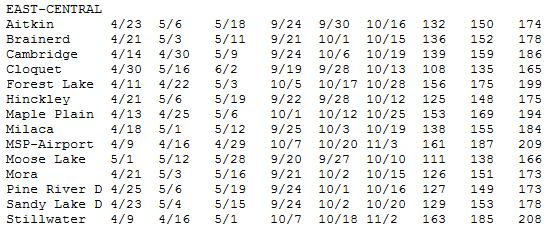
Median Data of Last 32 F Reading. For MSP
International the last 32 usually comes on April 29, May 3 at Forest
Lake and May 19 at Pine River. If you're really bored check out the data
for yourself, courtesy of the
Minnesota Climatology Working Group. Dan, I think you're probably safe to go ahead and feel fresh dirt underneath your fingernails.
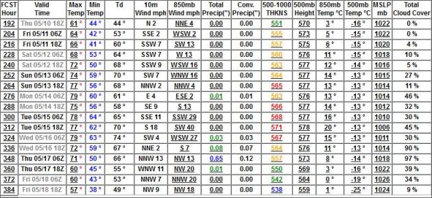
No Cold Fronts In Sight. The GFS shows a run of 60s
and 70s from May 10-18, even 1 or 2 das above 80. The only chance of
significant rain: May 17 (over half an inch predicted).
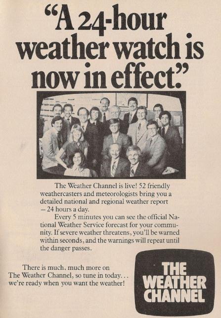
30 Years Of The Weather Channel. Happy birthday
Weather Channel! Short, boring anecdote. In 1982 I was working at SNC,
Satellite News Channel, owned by ABC and Westinghouse. It was an all
weather, sports and weather format, a 22 minute "wheel" of information
for the nation. Before I took that job (to be closer to my fiance who is
now my wife - at the time she was finishing up her architecture degree
at Penn State) I flew to Atlanta to meet with John Coleman, the
legendary founder of The Weather Channel. He couldn't have been nicer
(I remember him chain-smoking and drinking one can of Tab after another,
going on and on about what The Weather Channel would become). He was
right. They've done a remarkable job over the years, informing Americans
and making all of us more weather-wise.
TVNewser.com
has a good story about the 30 year anniversary of the launch of TWC;
here's an excerpt: "
30 years ago today, the world of cable television
changed forever with a very simple idea: what if there was a channel
where viewers could turn to and get the latest weather? And with that
simple idea, The Weather Channel was born. Now, of course, people get
their weather forecasts online or on their phones (usually through Weather.com,
which gets a redesign today, or an app made by Weather Channel), but
The Weather Channel stays with us. Whenever there is a big weather event
like a hurricane or blizzard, The Weather Channel is still the first
place people turn to for their meteorological news and information." Via
Cablevision’s
Jim Maiella,
check out this 1982 ad. (above)
How Weather.com Is Building A Social Media Alert System. Here's an excerpt of an interesting article from
mashable.com: "
Forget
the screeching emergency tone that interrupts TV and radio shows
during severe weather. The Weather Channel wants to build a weather
alert system based on social media, and it’s started laying down that
framework with a site redesign that launched Wednesday. The redesign,
among other updates, lets users tweet weather warnings or post them to
Facebook. Weather Channel VP of Web Products Mike Finnerty calls this
social media implementation “phase one.” The channel is working with
Facebook on “phase two,” which involves incorporating weather warnings
into Facebook’s open graph."
Viewer: WCAU Meteorologist "Saved My Life". This story shows the power of local broadcasters to truly serve their local community; here's an excerpt from
TVSpy.com: "
Last week, after undergoing double bypass surgery, WCAU chief meteorologist Glenn “Hurricane” Schwartz went public with his fight against heart disease, warning viewers about the symptoms.
Schwartz’s warning made an impact almost immediately, as one viewer
went to the emergency room after watching the WCAU story and found out
that his main artery was 99% blocked, just like Schwartz’s had been."
Fox Rant: Preempting Prime Time. For all the viewers
who become apoplectic when tornado warnings cover up "Dancing With The
Stars" - this one is for you, courtesy of
fox23.com: "
It
happens every time the weather gets bad enough, for us to preempt
normal programming to bring you Breaking Weather updates. A small but
very vocal minority of viewers gets upset. Not just a little upset,
really upset. The FCC says one of broadcasters' "most basic
obligations" is providing the public emergency information, specifically
mentioning tracking storms house-by-house."
Croatia's $980,000 Electric Supercar. Kind of defeats the purpose of a "green car". Oh well, here are details from
Fox News: "
Croatian firm Rimac Automobili used the recent Top Marques Monaco 2012 event to unveil the latest version of its Concept One electric supercar,
which has been upgraded with tires from Dutch firm Vredestein. While
the addition of new tires, even those designed by Italdesign Giugiaro,
isn’t all that exciting on its own, the big news is that Rimac’s
concept one is available for sale, though anyone interested will have
to fork over $980,000. Rimac is currently taking reservations and
deposits for a production version of the Concept One, which the company
says will be limited to just 88 units in total and enter production
next year."
Photo credit above: RIMAC.
Shades of June. It was nice to see the sun (without
staking out the nearest basement or storm shelter). Highs ranged from 75
at Alexandria to 81 in St. Cloud and the Twin Cities, 82 at Eden
Prairie. Rainfall amounts ranged from .13" at St. Cloud to 1.1" at
Crystal.
Paul's Conservation Minnesota Outlook for the Twin Cities and all of Minnesota:
TODAY: Warm sun, still sticky with a few stray T-storms (best chance south). Winds: W 10-20. High: 82
THURSDAY NIGHT: Another round of showers and T-storms possible. Low: 60
FRIDAY: Cloudy and cooler with light showers. Winds: NE 15. High: 69
SATURDAY: Cool and damp with steadier rain. Winds: E 10-15. Low: 51. High: 64
SUNDAY: Periods of rain. Soggy. Winds: E 15. Low: 51. High: 60
MONDAY: Clearing, turning cooler, drier. Low: 47. High: 62
TUESDAY: Mostly cloudy, chilly. Low: 44. High: 59
WEDNESDAY: More sun, free A/C. Low: 40. High: 63
Million Dollar Rain
"Are we done with frosty conditions for the
season in the metro area?" asked Park Nicollet's Roger Asplund? The
answer is a cautious yes. We'll cool off into the 60s from Saturday into
most of next week, nights may see readings in the upper 30s. There's a
lot of wisdom in that old adage "wait for annuals until after Mother's
Day."
We're seeing a multi-million dollar rain event for farmers
this week; some 1-4" rainfall amounts putting a sizable dent in our
long-term drought.
According to the Midwestern Regional Climate
Center 48% of Minnesota's corn was planted by April 29. That compares
with 1% last year. Our fast-forward spring limps on.
Waves of showers and T-storms bubbling up along a
fickle warm front will keep us partly-thundery today, tapering to light
showers Friday. A few storms may still turn severe later today,
especially over far southern Minnesota. If the sun stays out for a few
hours we may brush 80 F. today, but readings will probably hold in the
60s from Friday into the first half of next week.
The weekend? "How 'bout that stadium bill!" The
best chance of (heavier/steadier) rain comes Saturday into Sunday, as a
strong storm tracks just south of Minnesota - with the heaviest amounts
over central and southern Minnesota. Have a Plan B (indoors) for part of
the weekend, or just embrace the rain. For now I'm happy to see rain,
especially on a weekday.
Climate Stories...
"
Nature's laws affirm instead of prohibit. If you violate her laws you are your own prosecuting attorney, judge, jury and hangman." - Luther Burbank
Scientific Consensus Stronger Than Scientists Thought? Here is an excerpt from
The Yale Forum on Climate Change and the Media: "
More than two decades after the Intergovernmental Panel on Climate Change (IPCC) began publishing the latest scientific consensus
on the globe’s changing climate, widespread doubts persist in the U.S.
over whether there really is widespread agreement among scientists.
It’s the primary argument of those who deny basic scientific
foundations of warming. But new and innovative survey results suggest
the consensus among scientists might actually be stronger than the
scientists themselves had thought. The battles to define and debunk
scientific consensus over climate change science have been fought for
years. In 2004, University of California San Diego science historian Naomi Oreskes wrote about a broad consensus she found after studying 928 scientific papers published between 1993 and 2003."
Video: Extreme Weather And Rapid Arctic Warming. I
keep telling people that we are in uncharted waters, waters that are
becoming increasingly ice-free in the Arctic. What's fascinating (and
more than a bit troubling) to me is the teleconnection, the links
between what's happening in an Arctic region that's warming twice as
fast as North America, and a possible domino effect with jet stream
winds and configurations that may favor patterns getting "stuck."
Climate Central's meteorologist Andrew Freedman has more: "
Recently I reported on a study
showing links between rapid Arctic climate change and shifts in the
jet stream throughout the Northern Hemisphere. The study, led by
Jennifer Francis of Rutgers University, suggests that there may be an
Arctic connection to some extreme weather events, particularly ones
that result from stuck, or "blocked," weather patterns. "The study
shows that by changing the temperature balance between the Arctic and
mid-latitudes, rapid Arctic warming is altering the course of the jet
stream, which steers weather systems from west to east around the
hemisphere. The Arctic has been warming about twice as fast as the rest
of the Northern Hemisphere, due to a combination of human emissions of
greenhouse gases and unique feedbacks built into the Arctic climate
system. The jet stream, the study states, is becoming “wavier,” with
steeper troughs and higher ridges. As a result, weather systems are
progressing more slowly, raising the chances for long-duration extreme
events, like droughts, floods, and heat waves."
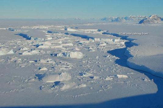
Stunning Antarctic Images Reveal Changes In Continent's Ice. Here's an excerpt from
Yahoo News: "
Photographs snapped last week of the Antarctic Peninsula
reveal a glittering landscape of ice and snow, crowned by rugged
mountains rising majestically in the distance. Yet no human captured the
stunning view — it was the work of machines. Thanks to the combined
technological powers of satellites and weather stations scattered around the Antarctic Peninsula,
researchers can now keep tabs on the region's shifting ice — which in
recent years has undergone dramatic changes — from the comfort of their
offices. AMIGOS 6, one of many specialized weather stations staked
around the region, took the above image on April 24 and relayed it to a
satellite the same day."
Climate Change's Impact On International Arctic Security. Here's a story from
The Energy Collective: "
Today we released a new report today titled Climate Change & National Security: The Arctic as a Bellwether.
The lead author of the report is Dr. Rob Huebert, Associate Director
of the Centre for Military and Strategic Studies at the University of
Calgary. Official military doctrine in the United States now holds that
“climate change, energy security, and economic stability are
inextricably linked.” Nowhere is this linkage more clearly illustrated
than in the Arctic, and that’s why we think the region is a bellwether
for how climate change may reshape global geopolitics in the post-Cold
War era."
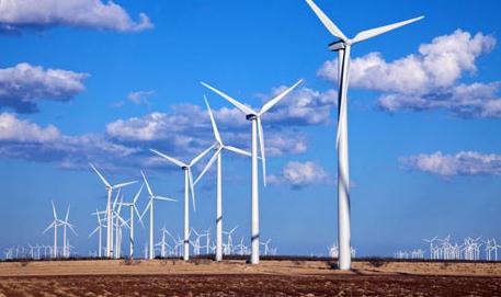
Impact Of Wind Farms On Land Surface Temperatures. Here is the paper that sparked a little mini-controversy at
nature.com: "
The
wind industry in the United States has experienced a remarkably rapid
expansion of capacity in recent years and this fast growth is expected
to continue in the future. While converting wind’s kinetic energy into
electricity, wind turbines modify surface–atmosphere exchanges and the
transfer of energy, momentum, mass and moisture within the atmosphere.
These changes, if spatially large enough, may have noticeable impacts on
local to regional weather and climate."
Obama: Focus On Climate Change To Bolster The Economy. Here's a snippet from a story at
Triple Pundit: "
From
Jimmy Kimmel Live to Jon Stewart to Rolling Stone, President Obama’s
re-election campaign is gearing up with a strong emphasis on youth and
particularly the left-leaning, activist youth vote. Tapping into the
same coalition that was instrumental in securing his victory in 2008 is
a crucial part of the plan for 2012. It might be a harder sell this
time around because of a fragile economic recovery, stubbornly high
unemployment — especially for grads and younger workers trying to enter
the workforce — and a well-financed opponent in Mitt Romney who will
say just about anything true or not, including blaming the president
for the economic disasters wrought by the Bush Administration, Wall
Street and an obstructionist Republican Party dedicated blocking
Obama’s every move."
Global Warming: New Research Emphasizes The Role Of Economic Growth. Here's an excerpt from a story at
physorg.com: "
That's the implication of an innovative University of Michigan study examining the evolution
of atmospheric CO2, the most likely cause of global climate change. The
study, conducted by José Tapia Granados and Edward Ionides of U-M and
Óscar Carpintero of the University of Valladolid in Spain, was
published online in the peer-reviewed journal Environmental Science and
Policy. It is the first analysis to use measurable levels of
atmospheric carbon dioxide to assess fluctuations in the gas, rather
than estimates of CO2 emissions, which are less accurate. "If 'business
as usual' conditions continue, economic contractions the size of the
Great Recession or even bigger will be needed to reduce atmospheric
levels of CO2," said Tapia Granados, who is a researcher at the U-M
Institute for Social Research (ISR)."
Climate Change And The Body Politic. Here's an excerpt from an article from
The New York Times: "
The latest installment in our Temperature Rising series, just published,
is about an argument between mainstream climate researchers and
contrarians over how clouds will change on a warming planet. As their
many other objections to climate science have been undermined by the
growing evidence, the contrarians have settled on clouds as a kind of
last-resort reason that the scientific majority just has to be wrong. In
the course of reporting the article, I had some intriguing
conversations with scientists who had thought hard about how to frame
the problem of climate change in the public mind."















No comments:
Post a Comment