83 F. high in the Twin Cities yesterday at 12:50 am (afternoon temperatures fell through the 70s).
80 F. average high for June 20.
77 F. high temperature on June 20, 2011.
.07" rain fell at KMSP Wednesday.
0" predicted rain for the next 84 hours, out through Saturday night (00z NAM model).
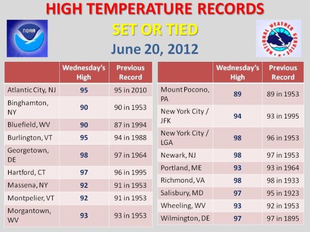
98 F. high at New York and Newark, New Jersey Wednesday - new records for June 20.
95 F. high at Burlington, Vermont, another record high.
2/3rds of the Duluth Zoo was underwater for a time yesterday.
Climate change. Did a warmer, wetter atmosphere
contribute to record flooding in Duluth? 3"+ downpours have doubled
since 1961 - details below. Photo: Duluth News Tribune.
Historic Duluth And Northland Flooding: June 19-20, 2012. The
Duluth office
of The National Weather Service has a good meteorological explanation
of what happened leading up to what may go down in the record books as
the worst flash flooding in Duluth history; here's an excerpt:
"
Three day rainfall amounts of 8 to 10 inches were common across
the Minnesota Arrowhead and northwestern Wisconsin from June 17th
through June 19th. The heavy rain took its toll on the road
infrastructure and caused rivers and streams to flood.
A cold front approached Minnesota from the High Plains on Sunday,
June 17th and this front set off numerous thunderstorms through the
evening. Duluth NWS received nearly an inch of rain (0.71”). The rains
that fell on Sunday had indundated the soil, and created more saturated
conditions than normal, which primed the Duluth area for runoff in the
extreme rain event that we received. On Tuesday, June 19th another
front slowly approached northeastern Minnesota. This front continually
formed thunderstorms that developed over east central Minnesota and
tracked northeast into the Duluth area, the north shore of Lake Superior
and into northwestern Wisconsin. The official rainfall in Duluth on
the 19th was 4.14 inches up until 1 am. The thunderstorms finally
ended when a strong cold front moved through Wednesday afternoon. The
rainfall on the 20th was 3.10”. Total rainfall for the large rainfall
event was 7.24”.
Numerous roads were washed out from the deluge of rain from
Carlton County through the Duluth metro area and into Douglas County
and Bayfield County in Wisconsin.
A state of emergency was declared in Duluth, Hermantown and Superior, WI."
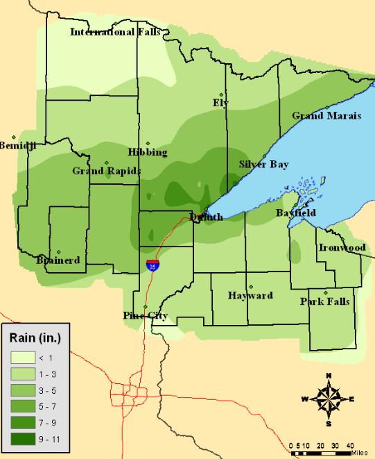
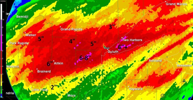
How Much Rain Fell. Thanks to the Duluth office of the NWS for posting this map, available
here.
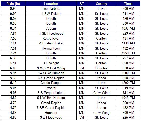
Staggering Amounts Of Water. Two Harbors picked up nearly 10" of rain, 8.38" in downtown Duluth. Graphic courtesy of the DLH National Weather Service.
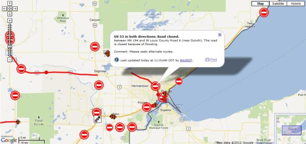
Road Closures. The Minnesota Department of Transportation has
real-time information
about flood-related road closures. Getting around The Northland is not
going to be easy anytime soon - many roads require significant repair to
support traffic.
Flash Flood Warning. Even though the rain is over,
the flood threat is not. Warnings remain in effect for the Duluth area;
here's the latest from The National Weather Service:
BULLETIN - EAS ACTIVATION REQUESTED
FLASH FLOOD WARNING
NATIONAL WEATHER SERVICE DULUTH MN
1026 AM CDT WED JUN 20 2012
THE NATIONAL WEATHER SERVICE IN DULUTH MN HAS ISSUED A
* FLASH FLOOD WARNING FOR...
NORTHEASTERN CARLTON COUNTY IN NORTHEAST MINNESOTA...
NORTHWESTERN DOUGLAS COUNTY IN NORTHWEST WISCONSIN...
SOUTH CENTRAL ST. LOUIS COUNTY IN NORTHEAST MINNESOTA...
* UNTIL 1030 PM CDT WEDNESDAY
* AT 1026 AM CDT...LOCAL LAW ENFORCEMENT OFFICIALS REPORTED FLASH
FLOODING ACROSS THE WARNED AREA. THERE HAVE BEEN EVACUATIONS IN
THE FOND DU LAC AND THOMPSON NEIGHBORHOODS...AS WELL AS SPAFFORD
TRAILER PARK IN CLOQUET.
* SOME LOCATIONS THAT WILL EXPERIENCE FLOODING INCLUDE...CARLTON...
CLOQUET...ESKO...FOND DU LAC...NEW DULUTH...OLIVER...PROCTOR...
SCANLON AND THOMSON.
PRECAUTIONARY/PREPAREDNESS ACTIONS...
ADDITIONAL RAINFALL AMOUNTS OF 1 TO 3 INCHES ARE POSSIBLE IN THE
WARNED AREA.
FLOOD WATERS ARE MOVING DOWN THE FROM THE HEADWATERS OF THE CLOQUET
RIVER DUE TO EXCESSIVE RAINFALL FLOWING THROUGH THE ISLAND LAKE
RESERVOIR. THAT FLOW WILL CAUSE SIGNIFICANT RISES DOWNSTREAM ALONG
THE SAINT LOUIS RIVER...AND WILL LIKELY CAUSE FLOODING FOR ADJACENT
AREAS ALONG THE SAINT LOUIS RIVER...INCLUDING CLOQUET...AS WELL AS
THE THOMPSON AND FOND DU LAC NEIGHBORHOODS.
Flooding Drowns Zoo Animals In Duluth, Minnesota. Here's an excerpt of a story at
msnbc.com: "
Several animals at the Lake Superior
Zoo in Duluth, Minn., drowned overnight when torrential rain caused
flooding across the city, swamping roads and sending sewage spilling
outside overflow tanks. "We have 11 confirmed dead animals, most of them
barnyard animals," zoo marketing director Holly Henry told msnbc.com.
"Two thirds of the zoo is under water." All but one of the zoo's
barnyard animals died, zoo spokeswoman Keely Johnson said in a
statement earlier. That included the zoo's donkey, goats and sheep."
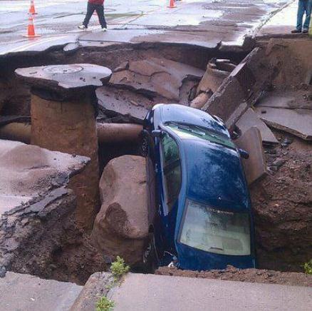
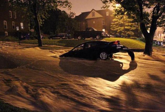
Photo credit above:
Andrew Krueger / The Duluth News-Tribune via AP. "A car is stuck in a sinkhole as floodwaters rush down a street in Duluth, Minn., early Wednesday."
* more on the sad story from the Duluth Zoo from
dl-online.com.
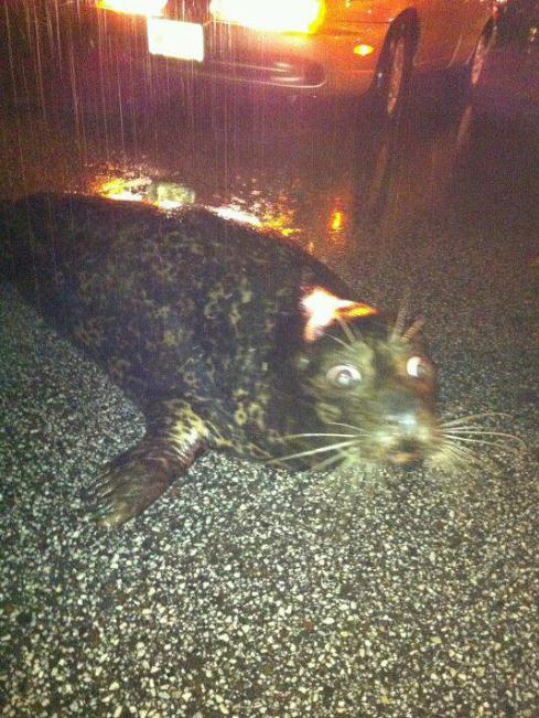
What The...? Duluth motorists were met with some
surreal sights at the height of flash flooding Wednesday morning. Feisty
The Seal was just fine, but other zoo animals didn't fare nearly as
well. Photo credit
here.
Duluth Zoo's Barnyard Ravaged; Escaped Seal Captured.
The Star Tribune has more information about a heroic effort to rescue as many zoo animals as possible.
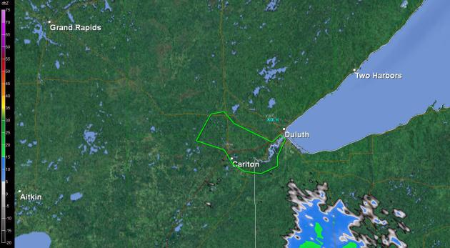
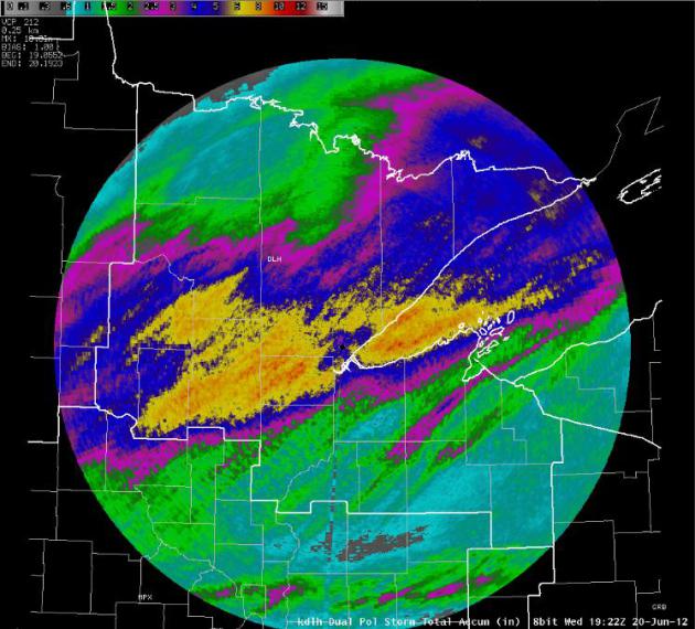
Dual-Pol Doppler. The Duluth office of the NWS just
turned on the new hardware/software upgrade to their Doppler - the Dual
Polarization Doppler can do an even better job refining raindrop sizes,
increasing our ability to estimate rainfall amounts. The
rainfall estimates (above) show a wide swath of 8-10" radar estimates.
Doppler Radar Rainfall Estimates. This is data from
the Duluth National Weather Service Doppler, showing a huge area of 4-6"
rainfall amounts from near Brainerd and Crosslake to Grand Rapids,
Duluth and the Iron Range - nearly 3 month's worth of rain falling in
less than 24 hours.
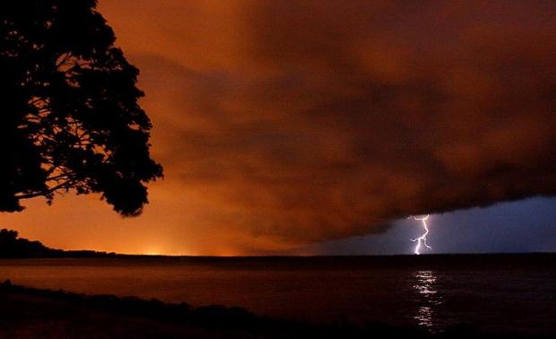
Photo Of The Day: Lightning At Lake Winnebago (Neenah, Wisconsin). Thanks to Brad Birkholz for an amazing photo of the storm moving in.
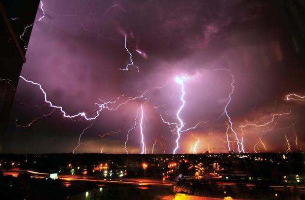
Like Something Out Of The Book Of Revelations. Check out this time lapse (I hope) photo taken in Minneapolis on June 19, courtesy of Eric Jaakkola. Amazing.
Record Heat On First Day Of Summer. Here is a short list of some of the scores of record highs set on Wednesday, courtesy of
NOAA.
"Here
is a list of the record highs set or tied today. There will likely be
even more tomorrow. Drink plenty of fluids and avoid prolonged work
in the sun or poorly ventilated areas."
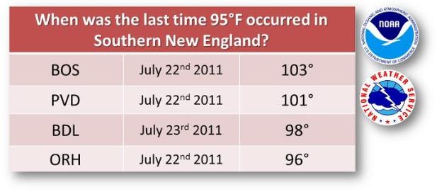
New England Heat Wave. The National Weather Service
has posted a graphic, showing the last time the mercury surged past 95
F. in Boston, Providence, Windsor Locks and Worcester. Source:
NOAA/Facebook.
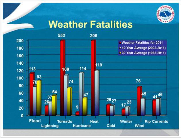
Heat: America's #1 Weather Killer. It may be
counterintuitive, but extreme heat/humidity claims more lives, on
average, than tornadoes, hurricanes, even floods. Map above courtesy of
NOAA.
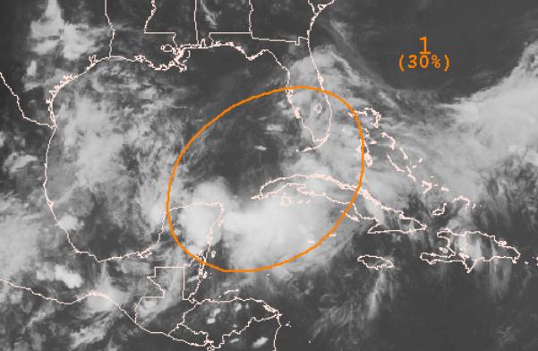
Tropical Depression. Could this swirl of clouds entering the Gulf of Mexico become "Debby". According to
NHC
there is now a 30% probability of strengthening into a tropical cyclone
within the next 48 hours - up from a 10% probability Tuesday evening.
In spite of considerable wind shear, water temperatures in the Gulf are
trending warmer than average, so further strengthening is a distinct
possibility. More from NHC:
A SHARP TROUGH OF LOW PRESSURE OVER THE SOUTHEASTERN GULF OF MEXICO
IS PRODUCING A LARGE AREA OF CLOUDINESS...SHOWERS...AND
THUNDERSTORMS THAT EXTEND FROM THE NORTHWESTERN CARIBBEAN SEA
ACROSS CUBA TO THE BAHAMAS AND FLORIDA.  STRONG UPPER-LEVEL WINDS
OVER THE GULF OF MEXICO ARE EXPECTED TO GRADUALLY DIMINISH...AND
SOME SLOW DEVELOPMENT IS POSSIBLE AS THE DISTURBANCE MOVES SLOWLY
NORTHWESTWARD TOWARD THE CENTRAL GULF OF MEXICO OVER THE NEXT
COUPLE OF DAYS.  THIS SYSTEM HAS A MEDIUM CHANCE...30 PERCENT...OF
BECOMING A TROPICAL CYCLONE DURING THE NEXT 48 HOURS.  HEAVY RAINS
AND LOCALIZED FLOODING ARE POSSIBLE ACROSS WESTERN CUBA...SOUTHERN
FLORIDA...THE CENTRAL BAHAMAS...AND THE YUCATAN PENINSULA THROUGH
FRIDAY.
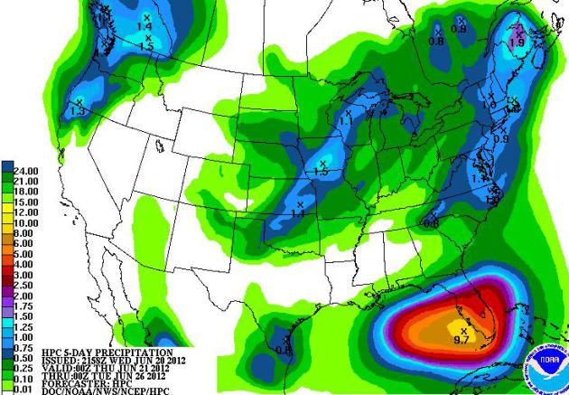
5-Day Rainfall Prediction. NOAA HPC's 5-day
prediction calls for 8-10" rains near Naples and Ft. Myers (from a
tropical depression that may strengthen into Tropical Storm Debby in the
coming days). The Pacific Northwest will pick up over 1" of rain, so
will major northeastern cities, breaking the heat wave by the weekend.
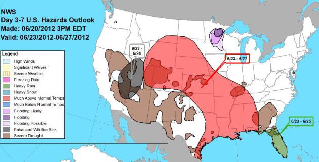
Weather Hazards.
NOAA
is predicting excessive heat for much of America's heartland, an
"enhanced" risk of wildfires from Las Vegas to Salt Lake City, flooding
rains for much of Florida.
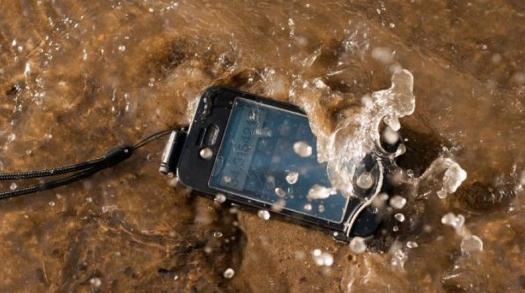
"driSuit" Case Keeps Your iPhone "dri" Under Water.
Hey, I don't write these headlines, but this one did catch my eye,
because I absolutely need to be checking my latest FB posts when I'm
swimming in the lake. Details from
gizmag.com:
"People just love their iPhones ... sometimes to the point where they
don’t want to stop using them when they enter the water. That’s why the
driSuit Endurance was invented. It’s a water- and shockproof case for
the iPhone 4 and 4S, that allows users to still take advantage of all of
the phone’s touchscreen controls – even when underwater."
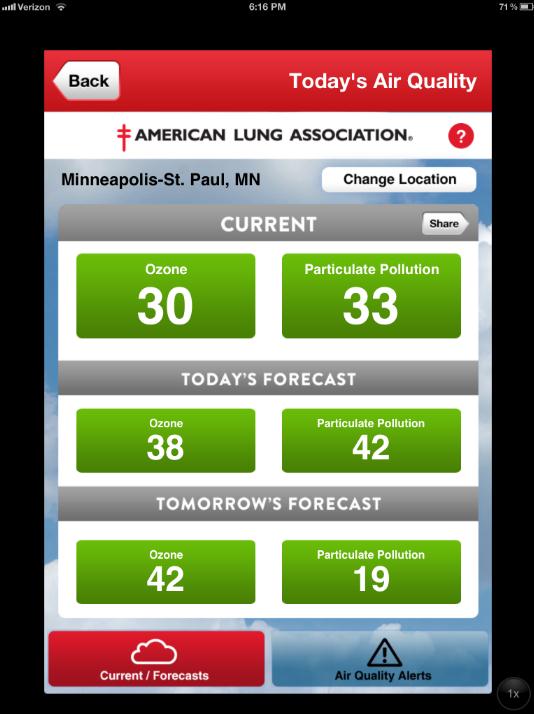
App Of The Day. Here is a free app, called "
State of the Air",
available on iTunes, that measures current air quality, and the
forecast for ozone, particulant pollution and other things you probably
don't want to be breathing into your lungs, courtesy of the American
Lung Association.
Apple TV: To Infinity And Beyond. Yes, we're still
dealing with rumors, but something (big) is cooking out in Cupertino.
Can Apple can do for television what it did for music and cell phones?
Stay tuned. Here's a portion of an article at
Seeking Alpha: "
Rumors have been swirling about a much anticipated Apple TV (AAPL) for several months, recently being semi-confirmed by Foxconn's investment in Sharp.
If the Apple TV turns out to be anything close to what the experts are
predicting, it has the potential to permanently change the TV
industry. Here's a look at both the positive and negative aspects of a
potential Apple TV, and what could make the it such a disruptive
product:
Pros
Possibility Of A La Carte Content
This is exactly what the cable industry is most afraid of.
Current leaders of the TV industry such as Comcast (CMSCA) and Dish
Network (DISH)
provide channel packages with a very standardized form, leaving very
little room for individual preference or customization. The possibility
of Apple being able to provide channels in an a la carte manner would
be far more cost efficient for consumers, who could only choose to
subscribe to the channels they prefer."
* image above courtesy of smokingapples.com, which has
another article about a potential Apple iTV.
Leaked: XBox 720 Slated For 2013 Release. Gamers may have a passing interest in this
gizmag.com post; here's an excerpt: "
Rumors about a possible next-gen Xbox have been swirling for quite awhile now, dropping minor details
like Blu-Ray support and major details like software that prevents
used games from playing. But those were tiny pebbles compared to the
avalanche of possible features that were recently revealed when a
56-page document purportedly leaked from Microsoft showed up online."
Graphic above courtesy of GraphJam.
Mom Really Shouldn't Use A Digital Camera.
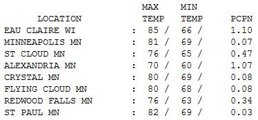
Wednesday Numbers. A threatening sky hovered
overhead much of the day, but the heaviest T-storms swept across central
and northern Minnesota, the cool front weakening as it drifted across
the metro area. Highs ranged from 70 at Alexandria to 76 St. Cloud, 83
in the Twin Cities (shortly after midnight). Over 1" of rain soaked Eau
Claire and Alexandria.
"
We are consumed by that we are nourished by." - William Shakespeare
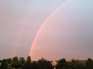
Double Rainbow. Thanks to
WeatherNation TV meteorologist Bryan Karrick for sharing this photo from Cologne.
Paul's Conservation Minnesota Outlook for the Twin Cities and all of Minnesota:
TODAY. Sweet relief. Partly sunny, breezy and pleasant. Dew point: 56. Winds: NW 10-20. High: 77
THURSDAY NIGHT: Clear to partly cloudy. Low: 60
FRIDAY: More sun, still comfortable. Winds:NW 10-15. High: 81
FRIDAY NIGHT: Clouds increase, slight chance of thunder by daybreak. Low: 62
SATURDAY: More clouds. Isolated T-shower possible. Dew point: 63. Winds: S 10-15. High: near 80
SUNDAY: Sunnier, nicer day of the weekend. Dew point: 58. Winds: NE 10+. Low: 64. High: 83
MONDAY: Sunny and beautiful (naturally). Low: 63. High: 81
TUESDAY: Intervals of sun, lukewarm. Low: 62. High: 82
WEDNESDAY: Hazy sun, warming up again. Low: 66. High: 86
An Unholy Weather Lotto
Why are we so mesmerized by the weather? The
technology? The uncertainty? Weather is democratic; we're all at the
mercy of the elements. Almost every day brings news of another weather
disaster. Will my neighborhood be next?
"We never see tornadoes or floods!"
Until you do.
Residents of Duluth are mopping up from what may
have been a 1-in-100 year flood. 8-10" rain in the North Woods?
Sinkholes, mudslides, roads washed away? Wednesday's flood may exceed
the previous high-water mark set in 1972.
This is why climate science matters. A warmer,
wetter sky is stacking the deck in favor of more extreme rainfall
events. Research shows 3" downpours across the Upper Midwest have
doubled since 1961. Weather on steroids.
What happened? A "train-echo" effect set up.
Much like the cars in a train pass over the same section of track,
T-storms kept redeveloping over the same counties, unleashing a summer's
worth of rain in 24 hours. Tropical floods in Duluth - who's next?
I wish I knew. Every day Mother Nature spins the wheel - all you can do
is hope and pray your number doesn't come up. Melodramatic? Tell that to
folks up in Duluth, still wondering what just happened.
Canadian air arrives today - we catch a break. A
fine Friday leads to T-showers Saturday - Sunday still looks like the
sunnier, drier day.
Sunny & quiet next week? Yes. Siren-free. Life vests and hip boots optional.
Climate Stories...
The Battle Over Climate Science. I know Michael
Mann. He's a fellow Penn State graduate, and one of the world's leading
climate scientists. I've gotten my fair share of insults, flame-mail and
angry e-mails by just reporting the state of climate science - but
nothing like what Micheal Mann has endured; nothing short of a global
campaign of harrassment and intimidation. He's a scientist - he didn't
sign up for this, but in spite of death threats and unimaginable,
vitriolic attacks Mann continues to publish and speak out on what he
believes will be one of the most important stories of our age.
Popular Science
has an impressive article that summarizes what the most ardent climate
denialists will do to try and shut up the most prolific researchers in
this field. Sad that it's gotten to this point. Here's an excerpt: "...
.“Weird”
is perhaps the mildest way to describe the growing number of threats
and acts of intimidation that climate scientists face. A climate
modeler at Lawrence Livermore National Laboratory answered a late-night
knock to find a dead rat on his doorstep and a yellow Hummer speeding
away. An MIT hurricane researcher found his inbox flooded daily for two
weeks last January with hate mail and threats directed at him and his
wife. And in Australia last year, officials relocated several
climatologists to a secure facility after climate-change skeptics
unleashed a barrage of vandalism, noose brandishing and threats of
sexual attacks on the scientists’ children. Those crude acts of
harassment often come alongside more-sophisticated legal and political
attacks. Organizations routinely file nuisance lawsuits and onerous
Freedom of Information Act (FOIA) requests to disrupt the work of
climate scientists."
Photo credit above: "
Heating Up."
Daniel Schumpert and Jason Briney
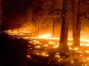
Connecting The Dots: How Climate Change Is Fueling Western Wildfires.
It's not your imagination - western fires are increasing in frequency
and intensity over time, and a warming (drying) climate, warmer winters,
and more pests are all conspiring to increase the odds of massive
fires.
Think Progress has a story, originally run at The National Wildlife Federation; here's an excerpt: "
Western
wildfires are dominating headlines in June – but the media coverage
focuses only on effects while ignoring a major cause. We hear about an
increase in the number and intensity of wildfires. And separately, we
hear about ongoing global warming, like how May was the 2nd-hottest on record globally
behind only May 2010. Why aren’t those dots being connected? There’s
compelling evidence that talking about western wildfires without
mentioning climate change is like talking about lung cancer without
mentioning cigarettes. I want to walk you through what’s happening out
west right now, what the latest science tells us about why it’s
happening, how it’s affecting people and wildlife in the region, and what we can do about it."
On Eve Of Rio Summit, Americans See Environment Deteriorating. The story from
The Washington Post; here's an excerpt: "
On the eve of a major gathering to discuss the state of the planet, a Washington Post poll shows
that most Americans think the world’s natural environment has
deteriorated over the past decade, and more than six in 10 say humans
are making the problem worse. Leaders from more than 130 nations will
meet in Rio de Janeiro on Wednesday for the high-level session of the U.N. Conference on Sustainable Development, also known as the Rio+20 Earth Summit.
The meeting, which happens once a decade, aims to identify how to
achieve economic growth without depleting the planet’s natural
resources."
Photo credit above: "
Agentina's President Cristina
Fernandez de Kirchner, second from left, gestures after arriving late
to Brazil's President Dilma Rousseff, second right, during the group
photo at the United Nations Conference on Sustainable Development, or
Rio+20, in Rio de Janeiro, Brazil, Wednesday, June 20, 2012. Bottom row
from left: Benin's President Boni Yayi, Agentina's President Cristina
Fernandez de Kirchner, France's President Francois Hollande, Sha
Zukang, Secretary-General of the Rio+20, and UN General Assembly Nassir
Abdulaziz Al Nasser, Brazil's President Dilma Rousseff. (AP
Photo/Victor R. Caivano)."
How Cities Are Leading The Way In Climate Change Fight. The story is in
greenbiz.com; here's an excerpt: "
When
it comes to solving climate change challenges, city mayors aren't
waiting around. On the eve of this week's Rio+20 event, a group of mayors around the globe announced
they have taken steps to slash emissions of greenhouse gases by 248
million metric tons in 2020, and by more than 1 billion tons by 2030.
The C40 Leadership Group,
which includes 59 cities producing about 14 percent of the world’s
greenhouse-gas emissions, have undertaken nearly 5,000 climate-related
actions since the network first formed in 2005."
What Does Climate Change Mean For Water In The Colorado River Basin? Here's an excerpt of an interesting story at
National Geographic. Clean water, not oil will quickly become the most precious natural resource on the planet. Here's an excerpt: "
Secretary
of State Hilary Clinton recently celebrated the work of an Israeli
scientist whose innovations in water conservation have been applied
throughout the Middle East, noting “the
importance of getting the most out of every drop of water. In many
regions of the world, water is either too scarce or too unpredictable to
sustain an American style of agriculture.” But it’s not
clear that the American Southwest can sustain an American style of
agriculture, or for that matter an American style of lawn. Nearly every
climate change model puts a red bulls-eye on the Colorado River Basin,
suggesting profound temperature increases over the coming decades."
Photo credit above: "
Sunset over the Rockies, which are soon to get hotter and drier." Credit: Rocket Scientist X, Flickr Creative Commons
Kaiser Permanente Links Climate Change To Health Care. Here's a snippet of a story at
Huffington Post: "
Kaiser
Permanente (KP), one of the largest health care providers in America,
has a clear mission: improve health. In a surprising and welcome twist,
KP is publicly recognizing that climate change threatens that mission.
This health care leader is showing how an authentic, mission-driven
connection to global issues can drive change. The topic of climate
change has become so politicized, it's rare to hear company
representatives and CEOs admit that they're taking a course of action
specifically in response to a climate-related threat. But that's
starting to change, even in sectors you might not think have a direct
stake in climate change."
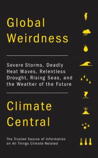
A Good Summary of "Global Weirdness" From Climate Central.
The meteorologists and climate scientists at Climate Central have just
published their first book, and it's worth a look. It summarizes some of
the jaw-dropping things I've been seeing on the weather map in recent
years. No, you're not imagining it - our weather is morphing into
Weather 2.0: warmer, stormier, more extreme rainfall events, intense
heat, drier droughts, more wildfires, increasing stress on water
resources - the list goes on. More from
Climate Central: "
There’s
always a sense of uncertainty in publishing a book. You think you did a
good job, and your editor presumably does, too — but that doesn’t
always guarantee that the rest of the world will end up agreeing. We’re
about to find out: Climate Central’s first book project officially hits
the stores on July 24. It’s titled Global Weirdness: Severe Storms, Deadly Heat Waves, Relentless Drought, Rising Seas and the Weather of the Future, published by Pantheon,
and it’s an attempt answer the challenge Thomas Friedman issued in the
New York Times back in 2010: “In my view,” he wrote, “the
climate-science community should convene its top experts — from places
like NASA, America’s national laboratories, the Massachusetts Institute
of Technology, Stanford, the California Institute of Technology and
the U.K. Met Office Hadley Centre — and produce a simple 50-page
report. They could call it “What We Know,” summarizing everything we
already know about climate change in language that a sixth-grader could
understand, with unimpeachable peer-reviewed footnotes.”









No comments:
Post a Comment