82 F. high temperature on Thursday in the Twin Cities.
76 F. average high for June 7.
103 F. high temperature on June 7, 2011.
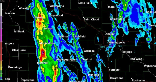
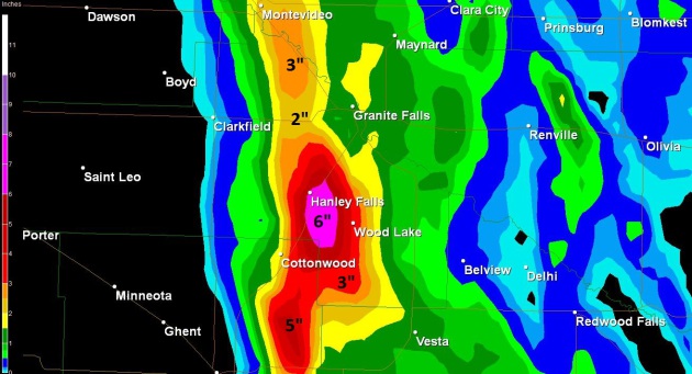
6" rainfall estimates near Hanley Falls yesterday. Details below.
.19" rain predicted today in the cities - showers and T-showers possible.
.30" rain scheduled for Sunday night into Monday morning as a cooler front arrives.
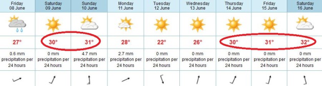
90-92 F. Saturday; dry with a south wind at 15-25 mph.
92-97 F. Sunday; south/southwest winds at 15-30 mph - showers and T-storms possible after 5 pm.
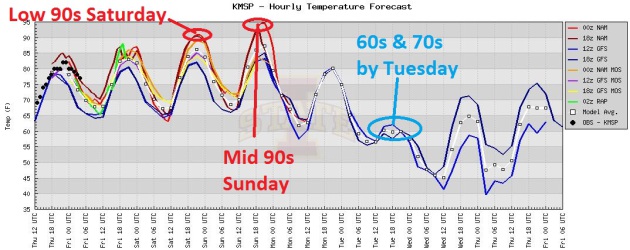
Hot Spell. We're still on track for highs near 90
today, low 90s Saturday and possibly mid 90s Sunday. After cooling to
near 70 for a high Tuesday temperatures warm again, reaching 90+ again
by the end of next week, according to the ECMWF model.
Trending Warmer. It's fascinating to see the
ECMWF take the lead, and the other (U.S.) models catching up as time
goes on. The European model was predicting 90s for the weekend as early
as Sunday of this week, while the GFS was predicting low 80s. Each run
got progressively warmer - now most of the models are suggesting 90+
Saturday and low to mid 90s on Sunday. Graphic courtesy of Iowa State.
"
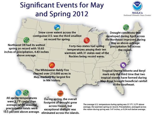
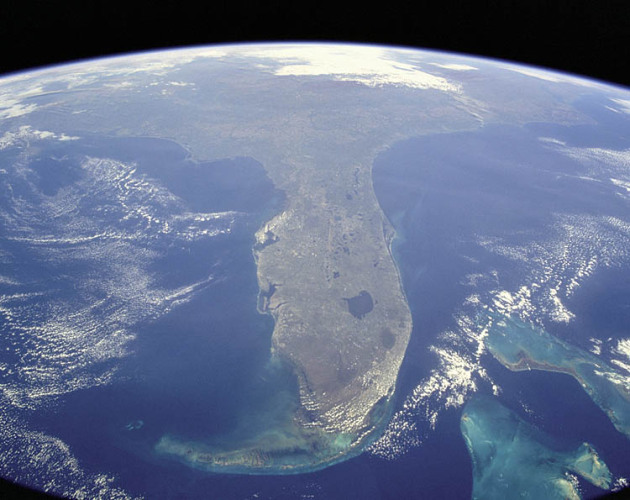
Record and near-record warmth dominated the eastern two-thirds of the nation during spring," according to the National Climatic Data Center report. "Thirty-one states were record warm for the season. Only Oregon and Washington had spring temperatures near normal." - from a USA Today article about a record warm spring for the USA; details below.
The "New (Warmer) Normal". Minnesota is heating up, which, on the face of it, sounds like a pretty good thing. There
will
be plenty of silver linings in the years to come as we continue to
warm: longer growing seasons, less snow and ice, a more temperate
climate that will attract new residents. Less fear of Minnesota's
"brutal winters". The downside: more extreme weather and record
downpours.... and potentially more pests, more ticks and beetles that
aren't killed off during our (warmer) winters, meaning a rising risk to
our North Woods. Pete Boulay at the Minnesota Climatology Working Group
sent me this e-mail yesterday:
"
The 12 month period from June 2011 to May 2012 is the warmest
June to May temperature in the Twin Cities, going back to 1872. I arrive
at 51.7 F. for the average temperature, and that beats second place
(2005-06), when the average temperature was 49.5 F.
We are also the warmest year to date from 1891-2012 (January 1 - June 6), although that probably isn't too surprising."
Here's the Top 3 (Warmest) Years for MSP (1891 - 2012):
1). 43.7 F. 2012
2). 42.9 F. 1987
3). 41.1 F. 2006
USA Had Warmest March-May On Record. Here's an excerpt from
USA Today: "
The surreal heat that enveloped much of the USA
this spring turned out to be a record breaker: Federal scientists
announced today that the spring was the warmest ever recorded in U.S.
history. Climatologists define spring as the months of March, April and
May; weather records go back to 1895. "Record and near-record warmth
dominated the eastern two-thirds of the nation during spring," according
to the National Climatic Data Center report. "Thirty-one states were record warm for the season. Only Oregon and Washington had spring temperatures near normal."
Second Warmest May - Hottest Spring On Record For USA. Details from
NOAA NCDC: "
The average temperature for the contiguous U.S. during May was 64.3°F, 3.3°F above the long-term average, making it the second warmest May on record. The month's high temperatures also contributed to the warmest spring, warmest year-to-date, and warmest 12-month period the nation has experienced since recordkeeping began in 1895."
"Train Echo Effect". Much like the cars in a train
pass over the same section of track, showers and thunderstorms kept
redeveloping over the same counties of central Minnesota yesterday,
resulting in some extreme rainfall amounts. MPX Doppler estimates show
some 6" amounts near Hanley Falls.
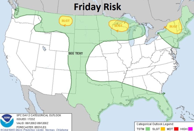
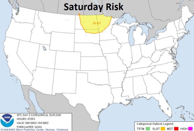
Severe Threat. SPC is predicting a slight risk of
severe storms over northern New England, northern Wisconsin and parts of
Montana later today - the threat shifts to North Dakota and the Red
River Valley Saturday as a slow-moving cool front pushes east.
118 mpg? The new Honda Fit is the most fuel-efficient car in the USA, but be prepared to dig deep into your wallet. Details below.
Severe Storms Hit Metro Denver.
KDVR.com has the details: "
DENVER
— Unusual overnight severe weather hit the metro area Wednesday into
Thursday, bringing lightning, thunder, heavy rain, hail and flooding to
much of the region. Despite several Tornado Warnings, there were no
confirmed tornado touchdowns with the round of late night storms. Hail
hit the southern and western parts of metro Denver especially hard.
Several inches were on the ground Thursday in places such as Castle
Rock, Parker and Highlands Ranch. Some roads were flooded and there was a
lot of standing water around the city. Motorists needed to allow extra
time for their morning commute Thursday."
Photo caption above: "
Hail at I-25 and Founders Pkwy. Castle Rock, Colo. June 6, 2012."
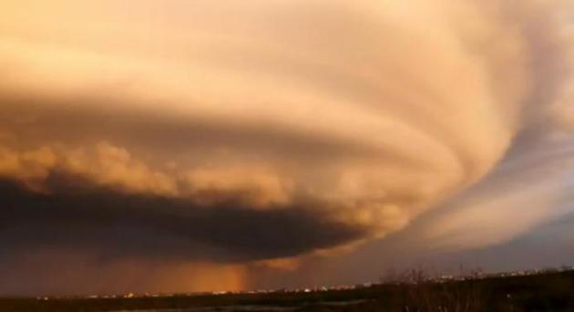
Supercells In Unlikely Places. It's a short
YouTube clip,
but unlike anything I've seen recently, video taken by Joe Prince up in
Bethel, Alaska! I had no idea Alaska even experienced rotating,
"supercell" thunderstorms.
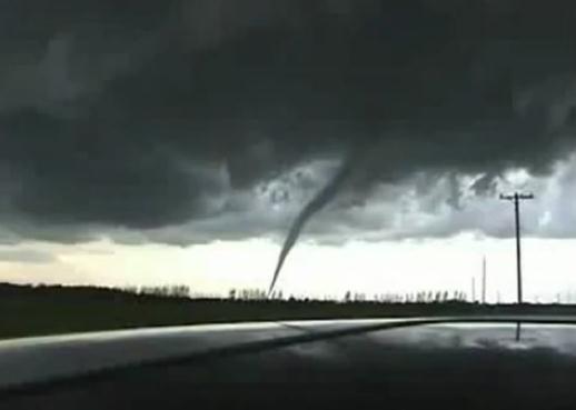
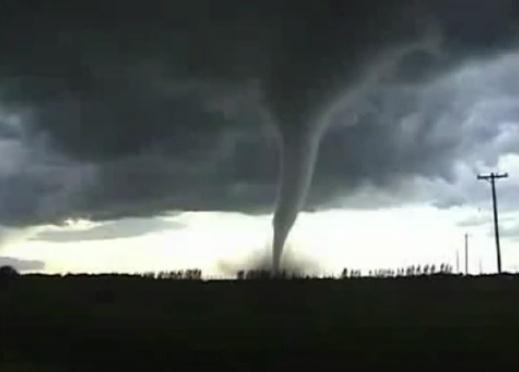
Holland Tornado. How good is your Dutch? I guess a
tornado needs no captions, even when it touches down in Europe - this
one is particularly fascinating to watch from beginning to end. Details
via
YouTube: "
Prachtige
beelden met schokkend commentaar op de tornado die ons prachtige
montfort trof op 7 juni 2012. De daken worden letterlijk van de huizen
gerukt door de onmenselijke kracht van deze natuurramp!"
Image Of The Day: Enterprise Moves To Intrepid. Thanks to Bill Ingalls of
NASA for sharing this moving photo. Details: "
Atop
a barge on Wednesday, June 6, 2012, the space shuttle Enterprise was
towed on the Hudson River past the Statue of Liberty on its way to the
Intrepid Sea, Air and Space Museum, where it will be permanently
displayed."
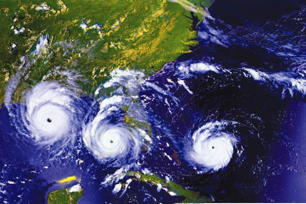
Welcome To Hurricane Season Circa 2012. The story from
Huffington Post; here's an excerpt: "
A hard rain's gonna fall. Question is how hard and how often. June 1 marks the official start of the Atlantic hurricane season. This year the atmosphere kind of jumped the gun by spawning two named Atlantic storms
-- Alberto and Beryl -- in May. That fast start out of the gate
notwithstanding, the official hurricane forecasts for 2012 envision a
fairly ho-hum year: see here, here and here. For example, the forecast by the National Oceanic and Atmospheric Association has a 70 percent chance of:
- nine to 15 named storms (with minimum wind speeds of 39 miles per hour),
- four to eight hurricanes (with minimum wind speeds of 74 miles per hour), and
- one to three major hurricanes (Categories 3 to 5 with minimum wind speeds of 111 miles per hour)."
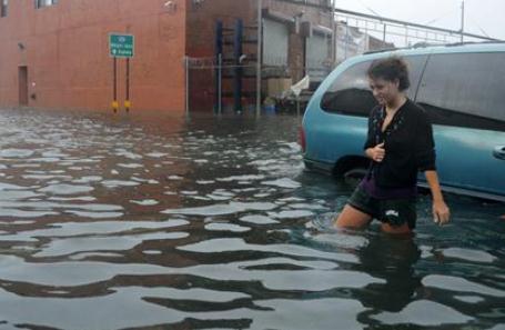
Study: Storm Surge From Hurricanes Threatens 4 Million Homes.
USA Today has an eye-opening story - here's an excerpt: "
A
survey of the USA's vulnerability to hurricane-driven storm-surge
damage found that more than four million homes worth over $700 billion
are at risk along the Atlantic and Gulf Coasts. Storm surge — the
massive mound of water that builds up and comes ashore as a hurricane
moves over the ocean or Gulf of Mexico— is typically the most dangerous
aspect of hurricanes. The report, released this morning by research
and consulting firm CoreLogic of Santa Ana, Calif., found that Florida
is the state most prone to storm-surge damage, with about 1.4 million
homes at risk, worth a total value of $188 billion."
Photo credit above: "
Maggie Dagrossi walks through flooded
streets in Brooklyn, N.Y., in August 2011, shortly after Hurricane
Irene hit New York City." By Chris Maddaloni, Gannett.
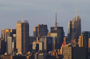
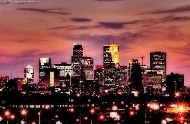
New York City At High Financial Risk For Hurricane Damage. Talk about a worst-case scenario;
The Christian Science Monitor has an important story - here's an excerpt: "
When people think of hurricane damage they usually think of Miami or New Orleans, but a new report suggests the greatest financial risk of all may be much farther north: the greater New York City area. Data analysis firm CoreLogic
said in a new report released on Thursday that the U.S. metropolitan
area at greatest risk, both in the number of properties affected and the
potential value of damage, was New York City. For the firm's purposes,
the area also includes Long Island and northern New Jersey.
"The summer of 2011 gave us some startling insight into the damage
that even a weak storm can cause in the New York City metro area,"
CoreLogic vice president Howard Botts said."
Photo credit above: "
The skyline of midtown Manhattan in
New York is seen at sunset from Jersey City, New Jersey June 3.
Pictured are the New York Times Building (L), the GE Building at
Rockefeller Center (2nd L), the Conde Nast Building (2nd R) and the
Bank of America Building (R)." Gary Hershorn/REUTERS
If A Hurricane Hits We'll All Pay. Here's an excerpt from an Op-Ed in
The Miami Herald: "....
Contrary
to news reports that continue to quote individuals who believe the
mention of crippling hurricane tax assessments is nothing more than a
scare tactic, the proof is in the numbers, and there are some things we
know for certain:
• Citizens is far from the insurer of last resort, with
approximately 25 percent of Florida’s homeowners insurance market and
rates that are about 40 percent below where they need to be to cover its
risk. Citizens claims are subsidized by non-Citizens policyholders,
which account for the 75 percent of Florida homeowners who have private
homeowners insurance. So, 75 percent of Floridians are not only paying
for their own risk but are also being taxed (assessed) to help pay
past storm claims for Citizens policyholders. And, depending on the
severity or frequency of storms that make landfall in Florida this year,
unfortunately and in all probability, they will be required to pay
more in the future."
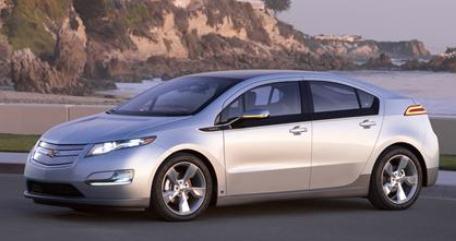
Chevy Volt Plug-In Sales Surge In California, Outsells 'Vette Too. Details from
The Washington Post: "
It's
quite the morning for electric-car news today, but we didn't want to
let one from yesterday slip by either. After a lumpy start to sales of
the Chevrolet Volt, it appears that California dealers now can't keep
the range-extended electric car in stock. According to an analysis of
registration data from January through March provided by R.L. Polk, the Detroit Free Press
reports that California bought more Volts by far--837 of them--than in
the second-highest state, which was Michigan at just 232."
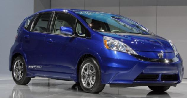
118 MPG? Honda Fit Most Fuel-Efficient Car In USA, But Steep Cost To Buy Electric Car.
The Washington Post and AP have the story; here's a clip: "
DETROIT
— At 118 miles per gallon, the Honda Fit electric vehicle is the most
fuel-efficient in the United States. But getting that mileage isn’t
cheap — and it isn’t always good for the environment. Honda announced
the eye-popping figure Wednesday, making the small, four-door hatchback
more efficient than electric rivals like the Ford Focus, Nissan Leaf
and Mitsubishi i-MiEV. It goes on the market this summer in Oregon and
California. The electric Fit has an estimated price tag nearly twice as
high as the gasoline-powered version. It would take 11 years before a
driver makes up the difference and begins saving on fuel."
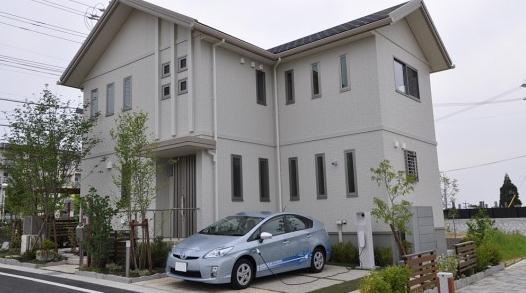
Toyota Vehicle-To-Home Technology Turns Prius Plug-In Into Emergency Generator.
O.K. Line up those Priuses in the parking lot so we can keep the lights
on - pretty cool idea though, especially when power goes out after a
thunderstorm rumbles through. Details from
gizmag.com: "
Electric
vehicle charging has been a hot topic for years, but it's mostly been a
one-way discussion: how the EV charges from a given home charging
system. Toyota turns the conversation around, experimenting with how
the home can draw power from the EV. Toyota's vehicle-to-home (V2H)
charging system offers two-way charging between the Prius Plug-in and a
home power supply. Obviously, the Prius Plug-in's small lithium-ion
battery isn't enough to pull a home off the greater electric grid, but
Toyota envisions the two-way system working as an emergency generator
during blackouts."
"
Groggy Boy After Surgery". In the mood for a
funny video clip; check out this entry to StupidVideos: "
This young guy is just out of surgery, and despite feeling a little dizzy, his confidence seems to be just fine!"
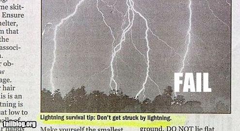
Lightning Fail. Thanks to failblog.org for passing this useful nugget along. I need to remember this...
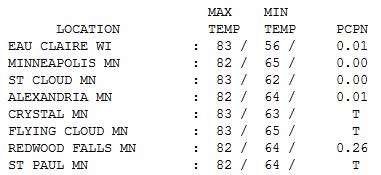
Feels Like June. Temperatures were fairly uniform
statewide yesterday with a mix of clouds and sun, slightly higher
humidity levels, and a band of persistent (heavy) showers and storms
during the morning/midday hours over parts of western and central
Minnesota. Highs reached 82 at the Twin Cities, 83 St. Cloud, with .26"
rain at Redwood Falls.
Paul's Conservation Minnesota Outlook for the Twin Cities and all of Minnesota:
TODAY: AM thunder? Hot sun. Dew point: 64 Winds: SW 15+. High: 89
FRIDAY NIGHT: Muggy, T-storms up north. Low: 68
SATURDAY: Hot sun. Dew point: 66. Winds: S 10-20. High: 92
SATURDAY NIGHT: Warm and sultry - dry. Low: 71
SUNDAY: Sizzling, uncomfortably hot and humid. Dew point: 70. Winds: High: 96
SUNDAY NIGHT: T-storms arrive, some heavy. Low: 69
MONDAY: Morning showers, thunder. Slow clearing, less humid. Dew point: 61. Winds: NW 10. High: 82
TUESDAY: Comfortable sun. Dew point: 54. Low: 57. High: 72
WEDNESDAY: Few T-showers likely. Dew point: 55. Low: 56. High: 75
THURSDAY: Partly sunny and sticky. Dew point: 63. Low: 60. High: 85
Warming Trend
Consulting meteorologist Dean DeHarpporte sent
me an e-mail earlier this week, the tone one of incredulity. "Paul, the
numbers are startling. Our last subnormal month at MSP was May 2011,
when it was 0.9 F degrees below average. Since then all months have
been above average, 7 of them by more than 5 degrees." DeHarpporte added
that the last 12 months have averaged 5.6 F above normal, but 2012 is
7.4 F above average; on track for the warmest year since 1891.
It's the "new normal": no more gradual heat waves that build over many days. Now we usually experience sudden "heat spikes".
I don't expect any records but we should hit 90
today - low to mid 90s Saturday & Sunday before a cooler front
provides a surge of Canadian relief. The dreaded dew point may top 70,
making it feel even more oppressive.
The atmosphere will be "capped", meaning too hot
and dry aloft for any storms to fire until late Sunday. Get thee to a
lake, pool or air-conditioned shopping mall, stat!
A cooling trend returns, highs in the 70s much of next week, although we may warm back into the 80s by the end of the week.
Finally, Pete Boulay at the Minnesota Climate
Office reports the 3 warmest years at MSP have occurred since 1987.
Eye-opening details on the weather blog.
Climate Stories...
Climate Change Message Needs To Be Closer To Home To Hit Home, Researchers Say. Details from
phys.org: " In a project that aimed to analyse public perceptions of global warming,
the researchers focused on ‘psychological distance’ in prompting
people to go greener and the significance of uncertainty as
justification for inaction. The study, led by Dr Alexa Spence, found
that in general the closer people felt to the problem, the more
concerned about climate change they were. It also recommends that more
needs to be done to communicate the global impacts of climate change
and highlight the severity of the problem....She said: “Climate change
is abstract, and if we make it more real for people then they are more
likely to act sustainably.”
Waffling On Climate Change? Consult Friends, Not Science.
I found this article to be something of a head-scratcher but the bottom
line is this: people often defer to friends and "group-think" when it
comes to potentially complicated, scientific challenges like climate
change. It's easier to agree with an influential friend than to dig into
the science and reach your own conclusions, based on the facts. Here's
an excerpt of a
Reuters article: "....
A
hierarchical individualist who expresses anxiety about climate change
might well be shunned by his co-workers at an oil refinery in Oklahoma
City. A similar fate will probably befall the egalitarian communitarian
English professor who reveals to colleagues in Boston that she thinks
the scientific consensus on climate change is a hoax. In other words,
people form opinions about climate change based on their worldview and
the views of the communities to which they belong. Science, yet again,
has little to do with it. These findings give heft to the vague feeling
that’s been dogging climate campaigners, that political affiliation,
not science, is what determines a stance on climate change."
Climate Change: It's The Science. Here's a snippet from Gannett's
Green Energy Blog: "
When
talking about climate change, the question that almost invariably
comes up is — how do we know that the current warming of the earth’s
atmosphere and oceans is the result of human activity and not just a
natural cycle? This is a valid question and not often well discussed, so
I have to hand it to the Union of Concerned Scientists (motto: Independent science, practical solutions) who have lived up to their name with a new book, “Cooler Smarter: Practical Steps for Low-Carbon Living.” The
book — and an interactive website the group has launched – sets
readers a challenge of cutting their personal greenhouse gas emissions
by 20 percent and lays out a range of well-documented, science-based
options for achieving the reductions by making changes in their everyday
lives."
Warming Nears Point Of No Return, Scientists Say. An ominous headline from
The San Francisco Chronicle: "
The
Earth is reaching a "tipping point" in climate change that will lead
to increasingly rapid and irreversible destruction of the global
environment unless its forces are controlled by concerted international
action, an international group of scientists warns. Unchecked
population growth, the disappearance of critical plant and animal
species, the over-exploitation of energy resources, and the rapidly
warming climate are all combining to bring mounting pressure on the
Earth's environmental health, they say. Scientists from five nations,
led by UC Berkeley biologist Anthony Barnosky, report their analysis
Thursday in the journal Nature."
Are We Nearing A Planetary Boundary? The
New York Times has the story; here's an excerpt: "
The
earth could be nearing a point at which sweeping environmental
changes, possibly including mass extinctions, would undermine human
welfare, 22 prominent biologists and ecologists warned on Wednesday.
Acknowledging in a new paper
that both the likelihood and timing of such a planetary “state shift”
were uncertain, the scientists nonetheless described warning signs that
it could arrive within a few human generations, if not sooner. The
problems are familiar by now: they include a planetary warming that, while slow on the scale of a human lifetime, is extremely rapid on a geologic time scale, the scientists said."
Geoengineering Projects: Global Warming Solution Or Climate Disruption? The story from
Huffington Post: "
LONDON
(Reuters) - Large-scale engineering projects aimed at fighting global
warming could radically reduce rainfall in Europe and North America, a
team of scientists from four European countries have warned.
Geoengineering projects are controversial, even though they are largely
theoretical at this point. They range from mimicking the effects of
large volcanic eruptions by releasing sulphur dioxide into the
atmosphere, to deploying giant mirrors in space to deflect the sun's
rays. Proponents say they could be a rapid response to rising global
temperatures but environmentalists argue they are a distraction from
the need to reduce man-made carbon emissions."
Are There Errors In The IPCC Reports? Here's an excerpt from
The Guardian: "
Every five to seven years, the UN's Intergovernmental Panel on Climate Change (IPCC) produces a detailed and influential report summarising the science of climate change.
The accuracy of these documents came under scrutiny in early 2010,
after two highly publicised errors were discovered in the 'Impacts,
Adaptation and Vulnerability' part of the Fourth Assessment Report (AR4). One was the claim that Himalayan glaciers could disappear by 2035 – hundreds of years earlier than the accepted figure – and the other was an incorrect number for the percentage of land in the Netherlands that is below sea level. Both mistakes were acknowledged by the IPCC and corrected in statements and errata notes."


No comments:
Post a Comment