72 F. high temperature on Friday in the Twin Cities.
74 F. average high for KMSP on June 1.
76 F. high last year, on June 1, 2011.
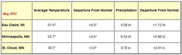
+ 4.6 F. May temperatures were 4.6 F. warmer than average in the Twin Cities.
.06" rain predicted for KMSP Sunday night (00z NAM model).
Warmer than average temperatures predicted for Minnesota looking out the next 2 weeks. Details below.
 4.34"
4.34" average June rainfall in the metro area (1970-2000 averages from
NOAA).
Weekend Summary
Today: mix of clouds/sun. Winds: NW 10-15. Highs: 72-77 F. Slowly falling barometer.
Sunday: Warm sun, a nighttime shower or T-shower. Winds: SW 5-10. Highs: 79-84. Falling barometer.
A Much-Needed Dry Spell. The ebb and flow of
weather, the ying and the yang of meteorology. After a May soaking
Mother Nature will take a badly needed breather in the coming 1-2 weeks,
a mostly-dry week shaping up next week, the only real chance of showers
and T-showers next Wednesday, according to the European (ECMWF) model.
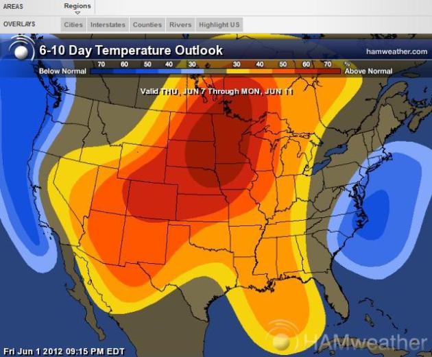 Beach-Worthy, Pool-Compatible
.
I'm liking what I see from CPC, NOAA's Climate Prediction Center -
forecasting a warm bulls eye right over Minnesota and the Upper Midwest
for not only the next 6-10 days, but looking out 2 weeks. Map courtesy
of
Ham Weather.
Second Wettest May On Record For The Twin Cities.
9.34" of rain fell last month, the second wettest since 1877, and the
wettest May since 1906, when over 10" of rain soaked the cities. Source:
Minnesota Climatology Working Group and Pete Boulay. Thanks Pete!
May Climate Summary. Here are some very impressive stats from the
Twin Cities office
of The National Weather Service: "After months of persistent drought
conditions across much of the area, the dry trend was completely
reversed in May. While May was warmer than normal, it will be remembered
for the high precipitation amounts, and ending the drought for most of
the area. In fact, the month began with drought and abnormally dry
conditions, and ended with multiple river flood warnings in effect. Some
of the heaviest rain was observed across central and eastern Minnesota.
- Minneapolis recorded its second wettest May on record with 9.34" of rainfall. The record is 10.33" set in 1906.
- St. Cloud recorded its second wettest May on record with 8.76" of rainfall. The May record is 9.68" set in 1912.
- The NWS Forecast office in Chanhassen recorded an impressive 11.23" of rainfall in May.
4th warmest May on record for Des Moines (average temperature of 68.5 F).
“
It’s highly likely that these fires are going to get so big that
states are going to need outside resources to fight them,” said Jeremy
Sullens, a wildland fire analyst at the National Interagency Fire
Center." - from a Washington Post article below focused on New
Mexico's largest wildfire, and the specter of more major fires to come
later this summer.
How To Kill Your Career In One Easy (Miami Beach) Evening.
ABC News 20/20 has the tale of John Bolaris, a great meteorologist who
got in over his head in a scam, and is still living with the
consequences. Details below.
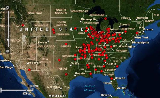
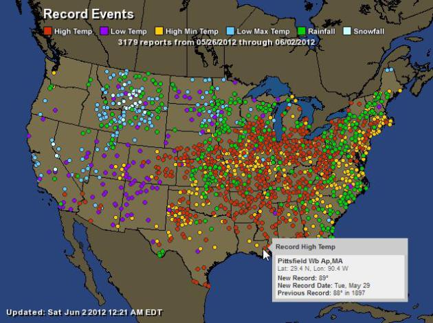
Warmest May Temperatures On Record. Every one of the
cities marked with a red dot experienced the warmest May temperatures
ever recorded. Here's a list of the cities from NOAA's
NCDC.
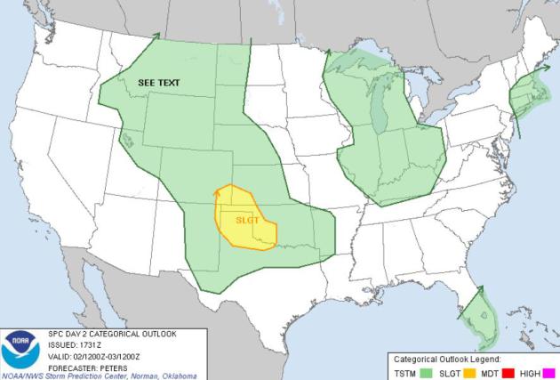 Saturday Severe Risk
.
According to SPC, the Storm Prediction Center, parts of the southern
Plains will experience a few storms with hail, damaging winds and
isolated tornadoes later today. The cool front that sparked a few
tornadoes from Pennsylvania into Maryland Friday is now sweeping all
that rough weather out to sea.
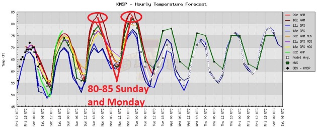
Looks Like Summer. No more frost up north -
temperatures reach the mid 70s today, but top 80 Sunday and Monday; mid
80s not out of the question early next week before temperatures cool
slightly. No scorching heat, but a spell of lake-worthy weather is
shaping up. Graph above: Iowa State Meteorology Department.
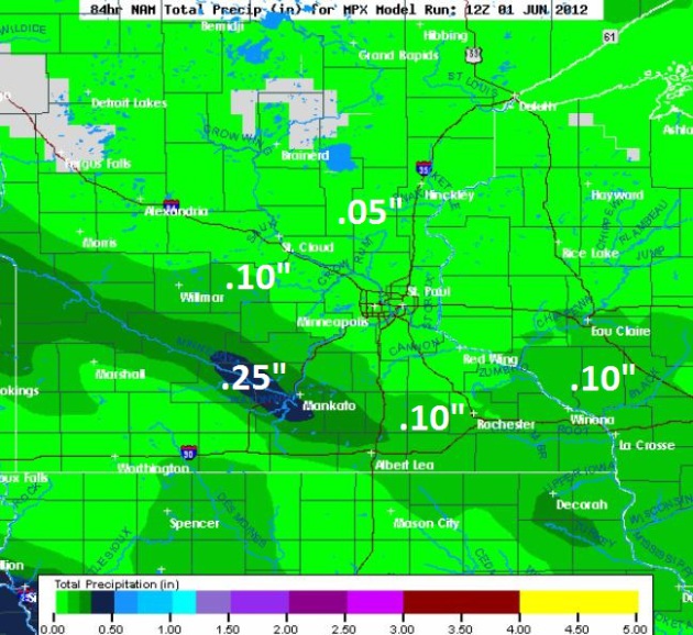
84-Hour Rainfall Outlook. A few showers and T-storms
are possible Sunday night, but the atmosphere will be too dry for any
heavy rain or severe storms. The best chance of a quarter inch of rain
tomorrow night: the Mankato area. NAM model data courtesy of NOAA and
Weathercaster.
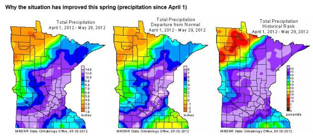
The Drought Is Over (For Much Of Minnesota). Here's the latest summary from the
Minnesota Climatology Working Group: "
As of May 29, the U.S. Drought Monitor places some northwest Minnesota counties in the Moderate Drought category. Stream flow measurements
at many locations in this part of the state rank below the 25th
percentile when compared with historical data for the date. Topsoil
moisture in portions of the Red River Valley is said to be Short.
Roughly one-third of the state is rated in the Abnormally Dry category.
The Abnormally Dry designation is often used by the U.S. Drought
Monitoring authors to indicate that the landscape is "coming out of
drought", with perhaps some minor lingering drought impacts. Over
one-half of Minnesota is free of drought designation. This week's map
shows substantial improvement in the drought situation when compared
with early May
when 60 percent of Minnesota was said to be in the Moderate Drought or
Severe Drought categories. The notable improvement in drought
conditions in the southeastern two-thirds of Minnesota is attributable
to an extraordinarily wet spring, including very heavy May rainfall totals."
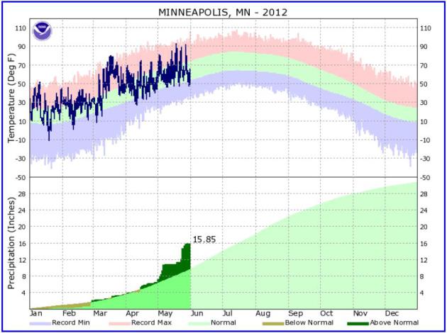
La Nina? La Schmeena... In spite of a La Nina
cooling phase through April, which correlates with colder, snowier
winters in Minnesota and northern tier states, temperatures have been
trending consistently above average since January 1. The 2012 graph of
temperatures and precipitation above is courtesy of the
local NWS.
May Recap. Here's a good summary of what turned out to be a warm and very wet May, from Mark Seeley and his weekly
WeatherTalk blog:
"In the simplest of terms May was warm and wet. Mean temperatures for
the month were 2 to 5 degrees warmer than normal, with several days in
the 90s F. The extremes for the month were 97 degrees F at Madison on
the 18th, and just 24 degrees F at Brimson and Embarrass on the 16th.
Minnesota reported the coldest temperature in the nation just twice
during the month. Rainfall during May was abundant and above normal in
all areas of the state except the northwest. Many individual climate
observers saw their wettest ever May. Some of these included:
Pipestone with 11.06 inches
Windom with 10.83 inches
Lamberton with 9.87 inches
Hawley 6.72 inches
Floodwood 9.14 inches
* Photo above courtesy of Yahoo.
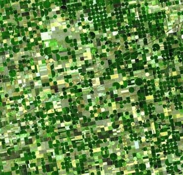
High Plains Farmers Depleting Groundwater, Study Says. Meteorologist Andrew Freedman from
Climate Central has the story; here's an excerpt: "
Irrigated
agriculture is rapidly depleting groundwater resources in parts of the
High Plains and the Central Valley region of California, which are
both critical regions for food production, according to a new study.
According to the study, if groundwater depletion were to continue at
current rates, 35 percent of the southern High Plains will no longer be
able to support irrigation within the next 30 years. With climate
change projections showing that more severe droughts in both the
Southwest and High Plains are likely as the climate continues to warm,
groundwater resources are going to be even more highly stressed in the
coming decades, the study says."
Photo credit above: "
Satellite image of fields that have
been irrigated by central pivot systems, which use less water than many
other irrigation methods. Credit: Wikipedia Commons."
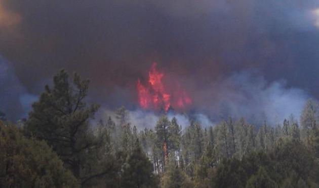
Massive New Mexico Blazes Marches Through Wilderness As Fears Grow Of More Western Wildfires To Come. Here's an excerpt from an update at
The Washington Post:
"
RESERVE, N.M. — A smoky haze hangs over the rugged canyons and
tree-covered expanses of southwestern New Mexico as the largest wildfire
in the state’s recorded history marches across more of the Gila
Wilderness. The virtually unchecked wildfire is fueling experts’
predictions that this is a preview of things to come as states across
the West contend with a dangerous recipe of wind, low humidity and
tinder-dry fuels. The Whitewater-Baldy blaze has charred more than
190,000 acres, or nearly 300 square miles, in Gila National Forest and
has become the largest wildfire burning in the country."
A Week's Worth of Temperature Records. Record 24
hour snowfall amounts for parts of Montana, while much of America east
of the Rockies continues to simmer - record rainfall reports from the
Midwest to the east coast. Truly something for everyone.
Click here for an interactive map from Ham Weather.
| Total Records: |
3179 |
| Rainfall: |
465 |
| Snowfall: |
42 |
| High Temp: |
1158 |
| Low Temp: |
154 |
| Low Max Temp: |
328 |
| High Min Temp: |
1032 |
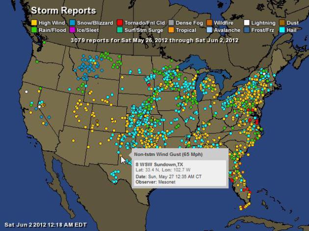
A Wild And Stormy Week. NOAA reports over 3,000
individual severe storm reports in the last week (not counting Friday).
We're heading into a quieter, drier pattern - I suspect next week won't
be nearly as severe from coast to coast. For an interactive map from Ham
Weather (one of my companies)
click here.
Atlantic Storm Forecast Raised By University Team.
MSNBC.com
and Reuters has more details: "Colorado State University researchers on
Friday raised their forecast for the 2012 Atlantic hurricane season to
13 tropical storms, with five hurricanes and two major hurricanes. In
April they forecast 10 tropical storms, with four strengthening into
hurricanes and two becoming major hurricanes with winds of at least 111
miles per hour during the six-month season that began on Friday. The
revised numbers would still be slightly below average for hurricanes in
the region that includes the Atlantic Ocean, the Caribbean Sea and the
Gulf of Mexico, the pioneering forecast team said.
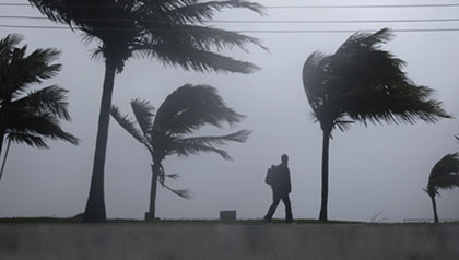
How Jacksonville TV Handles Hurricanes. Here's an excerpt of an illuminating, informative article about TV hurricane preparation from
jacksonville.com: "
They
offer First Alert Doppler HD and the 2-Minute Advantage to track
hurricanes, smartphone apps to alert us to bad weather and animation
software to dissect a storm's guts. But when Tropical Storm Beryl churned through a week before today's official start of the hurricane season,
that tech was augmented by all meteorologists on deck at Action News,
First Coast News and News4Jax. Using desks full of computers and their
accumulated knowledge, each station's weather experts gave viewers the
windy news in every way possible, starting with Beryl's approach to its
soaking departure through the rest of the week."
Photo credit above: WOODY HUBAND/Jacksonville.com. "
John
Gaughan, senior meteorologist at WJXT TV-4, says people shouldn't think
that meteorologists are "crying wolf" just becaues a hurricane hasn't
hit Northeast Florida in 48 years."
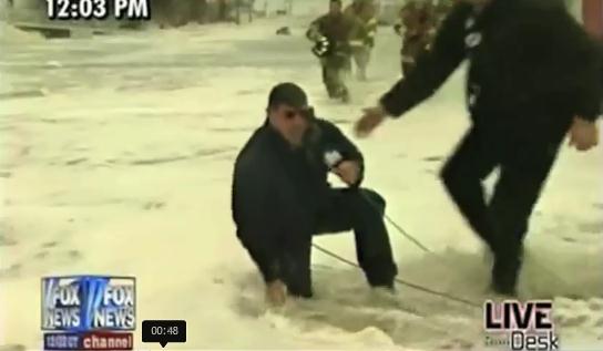
Hurricane Reporter (Fails). Don't you love it when
the meteorologists tell you to evacuate inland, while they're frolicking
on the beach, hanging onto poles, trying to keep from becoming
airborne? Here's a lovely tribute to everything stupid about hurricane
reporting from
Huffington Post: "
We
love weather reporters. They warn us about dangerous hurricanes and
tornadoes, giving us enough time to duck and take cover. That said,
we're also highly entertained that at the very same time that we're
taking cover, they're marching right into the eye of the storm with a
camera and microphone. And while their reports protect many of us from
getting injured, their (debatably excessive) bravery results in some
pretty entertaining footage."
Drugged, Scammed By Beautiful Women: Weatherman Tells His Story.
Wow, if this isn't a cautionary tale, I'm not sure what is. Note to
self: if it looks and sounds too good to be true, it probably is.
ABC News 20/20 has the story (and video) of John Bolaris, and how a weekend getaway in Miami went very, very bad: "
John
Bolaris was a TV weather forecaster in Philadelphia, but even he could
not predict the intentions of two comely women that approached him at a
luxury hotel bar in Miami. He woke up two days after the encounter with
little memory and even less money -- allegedly drugged twice on
consecutive nights and charged more than $43,000 on his credit card.
Bolaris had become another mark in a scheme run by an alleged Eastern
European crime ring. Hours of FBI surveillance videos and photos
obtained by ABC News show how the group of so-called bar girls, known
as "b-girls," lived and operated in South Beach -- targeting wealthy
male tourists and bilking them of thousands of dollars."
All-Electric Aircraft To Emulate Lindbergh's Historic Transatlantic Flight. Details from
gizmag.com; here's an excerpt: "
Eighty
five years ago, Charles Lindbergh became the first pilot to
successfully fly from New York to Paris non-stop, claiming a substantial
cash prize and securing a place in history in the process. Now another
world record holder, Chip Yates, has announced plans to take on the
same aviation challenge ... but this time the aircraft making the 3,600
mile non-stop flight will be all-electric. The ambitious project is
still in its early stages but the Flight of the Century team has
already developed a patent-pending battery deployment solution to
replenish depleted batteries while the aircraft is in flight."
Social Media Policies At GM, Target, Dish Network Deemed Unlawful By Labor Official. Details from
Huffington Post: "
WASHINGTON
-- In an effort to control employees' activities on Facebook and
Twitter, some U.S. companies have instituted social media policies that
run afoul of labor law and infringe on workers' rights, according to a
memo issued Wednesday
by the general counsel of the National Labor Relations Board. General
Motors, one of the largest automakers in the world, has gone so far as
to forbid employees from posting anything potentially "misleading"
about the company online and even told employees to be careful about
"friending" their co-workers on Facebook, the memo indicates."
How To Make Money On Mobile, In Three Easy Steps. Here's an interesting story from
cnet.com: "...
First,
the only apps and companies making significant money on mobile right
now are making most of that money off in-app purchases. The apps are
free, and if you want upgrades like extra jewels, more levels,
additional features and so on, you pay small amounts of money over time.
Research house IHS speculates that in-app purchasing would generate $5.6 billion in revenue
in 2012, up from $970 million in 2011. That number would equal fully 64
percent of app revenue. And in-app purchases can take all kinds of
forms: it doesn't just have to be buying extra jewels in Bejeweled 2 or the Mighty Eagle to get you out of your Angry Birds jam. It's a popular option in photo filter apps, fitness apps like Skimble are trying it for additional workouts, and the model works fine for subscriptions, as well."
Google To One-Up Apple, Announce 3-D Maps A Week Earlier (Video). Navigating not only 2-D, but 3-D spaces? Sounds pretty cool, and potentially powerful. Here's an excerpt from
mashable.com: "
At
an event entitled “The Next Dimension of Google Maps” next Wednesday,
Brian McClendon, vice president of Google Maps and Google Earth is
slated to give event goers an inside look at what’s in the works for
Google’s mapping service and “provide a sneak peek at upcoming features
that will help people get where they want to go – both physically and
virtually.”
Solar Geoengineering Could Lead To Whiter, Brighter Skies. And who wouldn't want whiter, brighter skies? Gizmag.com takes a look: "
We’ve already heard reports that placing small, reflective particles into the upper atmosphere could actually improve crop yields, but would also significantly reduce the amount of electricity generated by solar power plants and do little to arrest the acidification of the world’s oceans.
Now another potential side effect has been theorized by Californian
researchers, who say that solar geoengineering could lead to whiter
skies."
Photo credit above: "
Solar geoengineering could lead to whiter skies, similar to the hazy and white effect often seen in urban areas (Photo: Shutterstock)."
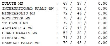
Pinnacle of Weather Perfection? I can't imagine a
nicer day: low 70s, low humidity, a gentle breeze, bug count under
control. Wow. Highs ranged from 54 at Grand Marais (raw breeze of Lake
Superior) to 72 at St. Cloud and the Twin Cities, 73 at International
Falls.
Paul's Conservation Minnesota Outlook for the Twin Cities and all of Minnesota:
TODAY: Mix of clouds and sun, mild. Winds: W/NW 10-15. High: 77
SATURDAY NIGHT: Partly cloudy and quiet. Low: 58
SUNDAY: Warmer with plenty of sun, stray nighttime shower or T-storm possible. Winds: SW 10. High: 83
MONDAY: Warm sun, a bit more humid. Low: 63. High: 83
TUESDAY: Sunny, summer returns. Low: 62. High: 84
WEDNESDAY: More clouds, isolated T-shower possible. Low: 61. High: 78
THURSDAY: Plenty of sun, still dry. Low: 59. High: 76
FRIDAY: Blue sky, storms stay south. Low: 59. High: 79
Weather Psychosis
Mother Nature needs medication. Lately our
weather has zigged and zagged between some pretty crazy extremes. Winter
snowfall in the Twin Cities goes from 86" one winter to 22" the next.
Over 60% of Minnesota was in a moderate or severe drought a month ago.
Now some rivers are overflowing their banks; a summer's worth of rain
soaked many Minnesota towns in May.
A moderate drought lingers up in he Red River
Valley - and it may expand in the coming weeks. I don't see any
significant rain (or severe weather episodes) through the second weekend
of June. I know, a meteorological miracle.
Good news for grad parties, June brides and
anyone hoping to fish, canoe, or loiter by the pool. A siren-free spell
of weather? Sounds good.
Patchy clouds arrive today but it should stay
dry. A T-shower is possible Sunday, but major storms and sloppy fronts
will detour south and west of Minnesota into next week.
No scorching heat in sight; comfortable 70s
today, highs hitting 80 Sunday - probably the better day at the
lake.
A quiet June? Makes sense. We had May in March. June is
the wettest, most severe month of the year. Kind of sounds like last
month. Confused? Join the club.
Have fun!
Climate Stories...
Hurricanes And Climate Change. Here's an excerpt of an interesting story from
cleanenergy.org: "
This blog is the first of a four-part series by Simon Mahan, Chris Carnevale and Jennifer Rennicks
on hurricanes and energy. Future blogs will focus on Hurricanes and
Wind Farms, Hurricanes and Coastal Adaptation, and Hurricanes and Oil
Rigs. Today officially marks the start of the 2012 Atlantic hurricane season
— the six months each year when hurricanes, tropical storms and
tropical depressions form in the Atlantic Ocean. While there’s nothing
particularly magical about the time between June 1 and November 30 that
precludes storms from brewing outside of this range, it is worth noting
that neither Tropical Storm Alberto nor Tropical Storm Beryl waited
for the official starting gun. Thus, for the first time in more than
100 years, two tropical storms with high enough wind intensities to
earn names have formed before the season officially began."
North Carolina Wishes Away Climate Change. Here's a clip from a fascinating story at
Mother Jones: "
Some
lawmakers will go to great lengths to deny the reality of climate
change. But this week, North Carolina lawmakers reached new heights of
denial, proposing a new law
that would require estimates of sea level rise to be based only on
historical data—not on all the evidence that demonstrates that the seas
are rising much faster now thanks to global warming. The sea level
along the coast of North Carolina is expected to rise about a meter by
the end of the century. But business interests in the state are worried
that grim projections that account for climate-induced sea level rise
will make it harder for them to develop along the coast line."
Photo credit above: "
Shad fishing on the NC coast, circa 1935 to 1940." State Archives of North Carolina/Flickr.
Climate Science: The X's And O's Of CO2. How sound is the science? Here's a good overview from
Huffington Post: "...climate "science" is a joke, not a scientific field."
-- Tom Blumer, NewsBusters Says you, Tom!... and the
U.S. Chamber of Commerce... and the
American Reform Party...But
just how legit are the scientific assessments of these unscientific
bodies? Let's apply a simple layman's litmus test and see if their
claims merit deeper analysis.
Is the basic premise of global warming even logical?
What on Earth has
previously addressed the soundness
of global warming's underlying formula. Greenhouse gases and the
greenhouse effect occur naturally in our environment. Earth would be
too cold for our survival without them, and their existence has been
proven by "
centuries of science, laws of physics and direct observation." A simple experiment can demonstrate CO2's heat-trapping properties, as you'll see at the 48-second mark of
this Bill Nye video. Or you can see the principle proven in
Mythbusters' "Young Scientists Special."
More Corporate Contradictions On Climate.
Huffington Post has the story; here's a snippet: "
A few weeks ago I wrote a piece
revealing that a number of major U.S. corporations that publicly
acknowledge the threat of global warming are members of the American
Legislative Exchange Council (ALEC), a stealthy lobby group that
ghostwrites legislation to scuttle climate change initiatives. This
corporate disconnect on climate goes way beyond ALEC. A new report
analyzing more than two dozen Standard & Poor 500 companies found
that despite their public pronouncements about the reality of global
warming, three-quarters of them at least indirectly hindered climate
change mitigation efforts through lobbying, campaign contributions,
agency comments, or their affiliations with trade associations and
advocacy groups."
Photo credit above: "
ConocoPhillips CEO James Mulva has
testified on Capitol Hill about the "potential long-term risks
associated with climate change," but his company has flip-flopped on
the issue for years." (AP)
Conservatives Attack Scientific Findings About Why They Hate Science (Helping To Confirm The Science). Here's an interesting post from Chris Mooney at
alternet.org: "
Two months have passed since my new book, The Republican Brain, was published, and so far it has gotten a lot ofmediaattention.
However, the coverage has followed a noteworthy pattern: while
progressives and liberals seem intrigued about what I’m saying, the
so-called “mainstream” media—the CNNs of the world—have shied away from
the subject. What’s up with this? Well, a book with conclusions closely
related to mine—Norman Ornstein’s and Thomas Mann’s It’s Even Worse Than It Looks: How the American Constitutional System Collided With the New Politics of Extremism—seems as though it is being handledsimilarly by
some in the press. And perhaps there’s a reason: Centrist (aka
“mainstream”) journalists might well prefer that the findings of these
books not be true."
Photo credit above: shutterstock.com.
Companies Need To Disclose Climate Risk: Investors.
Reuters has the story; here's an excerpt: "
Institutional
investors and environmental advocates on Thursday urged companies to
disclose their risks from the impact of climate change, two years after
the Securities and Exchange Commission issued guidelines for firms to
do just that. While the
SEC guidelines do not force publicly traded corporations to assess such
climate-related events as severe storms, droughts, floods and heat
waves, some companies have done so anyway. But those disclosures have not been particularly useful, according to Maryland State Treasurer Nancy Kopp."
The People-Power-Inflicted Downfall Of Heartland. Details from
The Huffington Post: "
It
has been a rough few weeks for the Heartland Institute, the
"intellectual" nexus of the fossil fuel-powered machine to disparage
climate science in the United States. Nineteen corporations have pulled
more than $1 million in expected funding, leading President Joe Bast to
ask attendees at the recent Heartland climate denial conference
whether they had a "rich uncle"
who could help out. Seriously. In a time when most news about climate
change is bad, Heartland's decline has been a rare bright spot. Which
has caused many observers to tackle the obvious question: how did this
happen? In the reductive rendering of the mainstream media, the
narrative has become that Heartland simply overplayed its hand by
launching a billboard campaign
comparing people who believe in global warming to the Unabomber and
Osama Bin Laden, one of the single dumbest PR moves in recent history."


No comments:
Post a Comment