High anxiety
By: Paul Douglas
"We're still shell-shocked around here.
When storms pop up we pay attention to the meteorologists" my
sister-in-law, Diane Wright, confided. After a late June derecho,
packing 90 mph gusts, carpet-bombed her Washington D.C. suburb (Potomac)
the neighborhood looked like a war zone. "It was post Apocalyptic" she
sighed. "Everyone has a story. People are traumatized - many have bought
emergency generators. People are still having flashbacks..we don't
ignore the warnings anymore" she added.
Much of the USA has a healthy case of
PTSD: Post Traumatic Stress Disorder. In a recent survey 2 out of 3
Americans said they were personally impacted by extreme weather in the
last 2 years. "What's wrong with the weather?" Good question. How much
time do you have? Some days I wonder if Mother Nature isn't having a
nervous breakdown.
Minnesota will be on the northern
periphery of blast-furnace heat this week; today and tomorrow the
hottest days (low to mid 90s). Swirls of energy rippling along a stalled
front may spark heavier T-storms by midweek; the worst of the heat
shoved south, over Iowa.
More significant relief is possible next week as Canadian air finally pushes south. What a summer.
______________________________________________________________________________________________
Todd's Conservation MN Outlook for the Twin Cities and all of Minnesota:SUNDAY: Front lifts back north early with a slight chance of thunderstorms early. Dew point: Near 70. Winds: SSE 10-15. High: 93
SUNDAY NIGHT: Slight chance of overnight thunder. Low: 73
MONDAY: Another very warm and unsettled late. Intervals of sticky sun. High: 93
TUESDAY: Still summery with a slight chance of thunder.. Low: 73. High: 88
WEDNESDAY: Sweaty with some heavy downpours. Low: 74. High: 86.
THURSDAY: Warm streak continues... passing thundershower potential. Low: 72. High: 90.
FRIDAY: A slight break in the heat? Lingering afternoon shower or brief storm. Low: 69. High: 86.
SATURDAY: Quiet with sun. Not as hot or humid. Low: 68. High: 85
_________________________________________________________________________________________
Saturday Sunset
Can't complain about the sunset last
night... really was something to marvel at. Had a chance to chat with a
couple enjoying the weather on the outdoor patio of a local restaraunt;
good conversation. Somebody mentioned that it was a little hot or almost
too humid, but I said I'd take this over 30 below wind chill ANY day!
Summers are short, enjoy them!

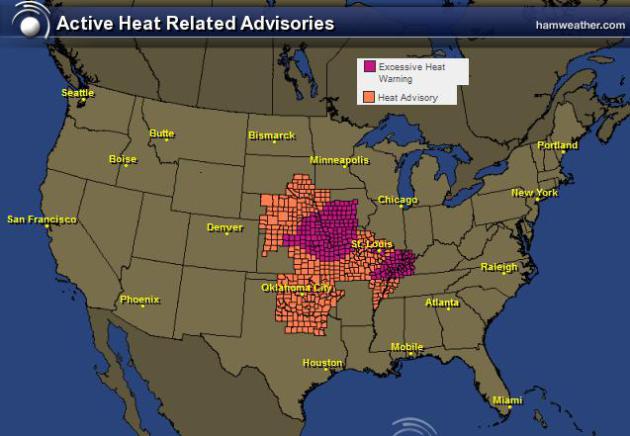
Extreme Heat Continues
The National Weather Service continues
excessive heat headlines for many locations in the central part of the
country. In some locations, afternoon heat index values could top out
around 110F... YIKES!
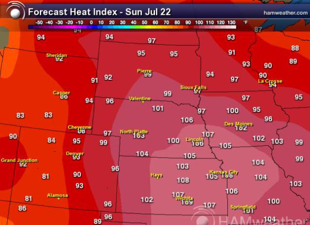
Afternoon Heat Index
Maximum heat index values on Sunday in the central part of the country are listed below...
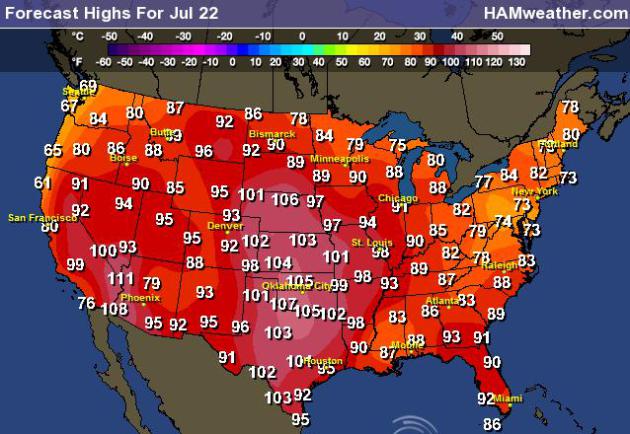
High Temperature Forecast for Sunday
Actual air temperatures on Sunday will be in the 90s and 100s once again with some nearing record highs.
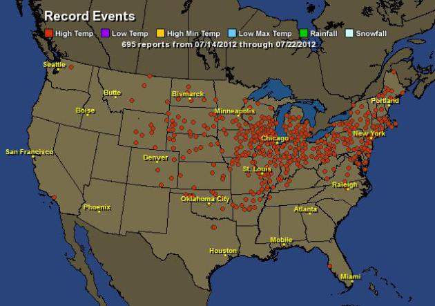
Record Highs Continue to Fall
According to Hamweather.com there have been nearly 700 record high temperatures either tied or broken.
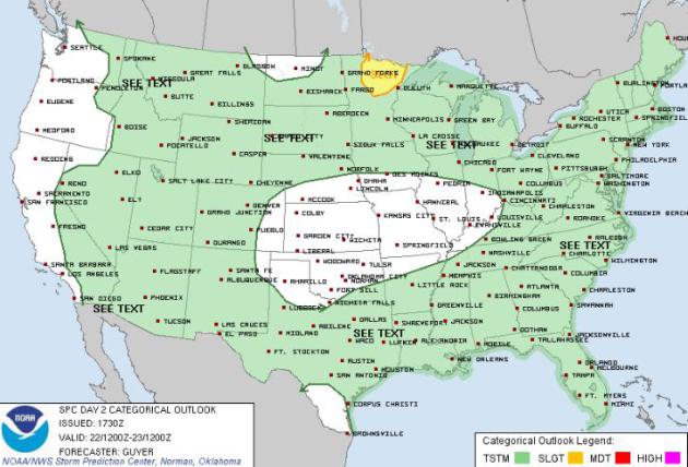
Sunday Storm Threat
The Storm Prediction Center has a SLIGHT RISK of severe weather across far northern Minnesota of Sunday.
However, showers and isolated thunderstorms will continue to rotate
around the center of extreme heat, so areas shaded in green will have a
slight chance at seeing a few strong thunderstorms during the day
Sunday.
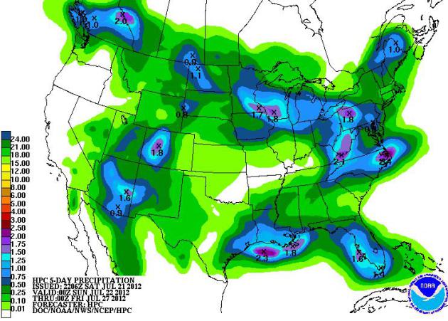
5 Day Rainfall Forecast
NOAAs
HPC 5 day rainfall forecast shows several pockets of heavy rainfall,
but still mostly dry in drought stricken areas of the mid-section of the
country.
Thanks for checking in, have a great rest of your weekend!
Don't forget to follow me on Twitter @TNelsonWNTV

No comments:
Post a Comment