81 F. average high for August 11.
84 F. high on August 11, 2011.
9" rain in the metro since June 1.
9.9" average amount of rain at KMSP between June 1 and August 11.
"However, the summer figures provide the real shock. In 2004 there was about 13,000 cubic kilometres of sea ice in the Arctic. In 2012, there is 7,000 cubic kilometres, almost half the figure eight years ago. If the current annual loss of around 900 cubic kilometres continues, summer ice coverage could disappear in about a decade in the Arctic." - excerpt from an article at The Guardian below; new research from The European Space Agency's CryoSat-2 satellite suggests summer ice loss in the Arctic is 50% higher than computer models have been predicting.
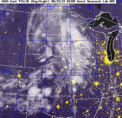
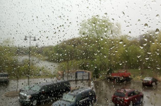
Good Mall & Movie Day. We're running nearly a 1" rainfall deficit since June 1 in the Twin Cities, so yes, "we need the rain". Certainly southwestern Minnesota, in the midst of a severe drought, really needs some rain, so in spite of the lousy timing - no whining about today's puddles. A weak twist of cold air aloft will keep us mostly cloudy today with a few light rain showers - the atmosphere overhead to stable and cool for anything severe. Image: Naval Research Lab.
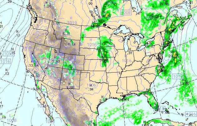
Sunday Weather Map. The WRF model, valid at 4 pm today, shows rain showers from central Minnesota southward to Kansas City (strong storms possible from Des Moines into northern Missouri). Rain lingers for coastal New England with more strong to severe storms over Florida, dry weather the rule over the western third of the USA.
Big Temperature Swings. Another day, another glance at the ECMWF, which keeps us showery into a portion of Monday, then warms us up into the mid and upper 80s by Wednesday (with strong to severe T-storms late in the day). Those storms herald the arrival of another cool front; highs may hold in the 60s to low 70s (southern MN) Thursday and Friday. Right now the outlook for next weekend is promising; sun both days - Sunday the better day for the lake with highs near 80. 90 F. temperatures may return by Monday of next week.

"We have 3 open foursomes and would LOVE it if any of them got filled! The cost is $2,500 and includes everything (driving range, putting green, lunch, golf, contests, dinner, great silent auction, program) at the private, prestigious TPC in Blaine. It would be amazing if someone wanted one of these last few spots, and all for a good cause too. Why should they come out for this Monday:
* It'll be a great day with perfect weather; $5,000 cash hole-in-one contest, gift cards from local sports stores, special gift for golfers from the Mall of America, pictures with me (wow), Bill Popp from Popp.com, free cigars and much more!
* To support a local charity that doesn't get the public attention because of the topic.
* Because suicide is the 2nd leading cause of death for youth in our state, 3rd leading cause of death for all adults.
* To help reduce the stigma surrounding mental illness by participating in the event, especially wen there are 25 million adults living with clinical depression every day.
Bottom line: for every dollar raised by golfers coming out, we can literally save lives! A $2,500 golf foursome allows SAVE to distribute 12,500 wallet cards to youth, military and law enforcement personnel with life-saving information on it.

** Non-golfers are more than welcome for the appetizer hour, silent auction and dinner program beginning at 5:30 pm. Tickets for that are $30. More on SAVE's upcoming events here.
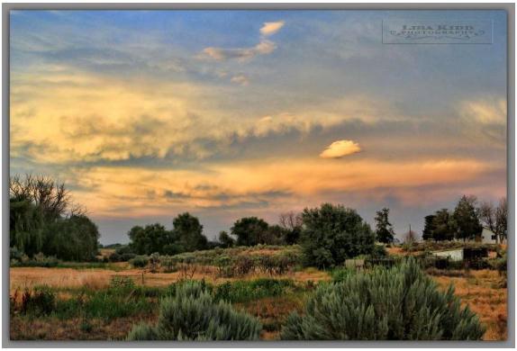
I'm There. Yes, a few days in Idaho would cure me. Thanks to Lisa Kidd for passing this photo along.


Where Cars Go To Die. That would be The Wyoming State Fair. Looks like fun.
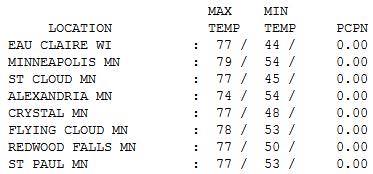
Decent Saturday. Yes, the high and mid level clouds rolled in faster than predicted, but temperatures still reached the upper 70s in the metro area, in spite of a thick smear of cirrus clouds. Highs ranged from 74 at Alexandria to 77 St. Cloud, and 79 in the Twin Cities.
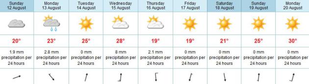
Paul's Conservation Minnesota Outlook for the Twin Cities and all of Minnesota:
TODAY: Cool, damp and showery. Winds: SE 5-10. High: 69
SUNDAY NIGHT: Mostly cloudy, a few more showers and sprinkles. Low: 58
MONDAY: Lingering clouds and showers, then partial clearing, milder. High: 77
TUESDAY: Warm sun returns. Dew point: 53. Low: 62. High: 82
WEDNESDAY: Hot sun, late T-storms. Dew point: 61. Low: 64. High: 87
THURSDAY: Breezy, cooler. Less humid with intervals of sun. Dew point: 54. Low: 61. High: 70
FRIDAY: Comfortable sun, light winds. A fine example of mid-September. Low: 55. High: 72
SATURDAY: Mild sun. Lake-worthy again. Low: 57. High: 75
Living In The Moment
"Life isn't about waiting for the storm to pass.
It's about learning how to dance in the rain" said Vivian Greene.
Weather is a good metaphor for life. Endure the stormy squalls, get thru
the bad times, knowing the sun will inevitably return - things will get
better. The most successful people I know are not immune from
heartbreak or pain. Nobody gets a free pass.
One of my (many) bad habits: the need to
photograph & digitize every memorable moment. I no longer seem to
enjoy a sunset. Now I feel like I have to document it, post it, share it
on Twitter and FB. Like it somehow isn't real unless there's a social
trail of digital bread-crumbs. It's a bad habit I'm trying to break.
No photo-worthy moments today. A cyclonic swirl
of low pressure sparks a few hours of rain; more hints of autumn, with
highs stuck in the 60s. A good day to read the paper cover to cover, or
take in a bad movie. Expect a drier, brighter sky north of Brainerd.
We warm to near 90 F by Wednesday, then cool 20 degrees by Thursday.
Summer is taking a brief siesta, but more warm
days are brewing. I see a streak of 90s next week. Besides, The State
Fair is coming. Plenty of deep-fried, sweaty days ahead!

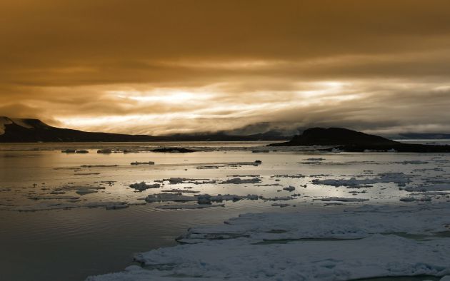
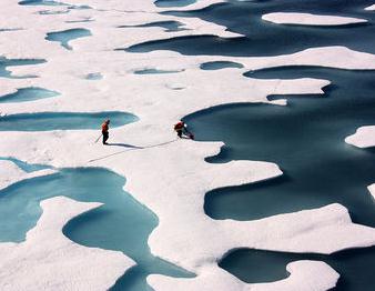
Rate Of Arctic Summer Sea Ice Loss Is 50% Higher Than Predicted. Some troubling news from the U.K. Guardian; here's an excerpt: "Sea ice in the Arctic is disappearing at a far greater rate than previously expected, according to data from the first purpose-built satellite launched to study the thickness of the Earth's polar caps. Preliminary results from the European Space Agency's CryoSat-2 probe indicate that 900 cubic kilometres of summer sea ice has disappeared from the Arctic ocean over the past year. This rate of loss is 50% higher than most scenarios outlined by polar scientists and suggests that global warming, triggered by rising greenhouse gas emissions, is beginning to have a major impact on the region. In a few years the Arctic ocean could be free of ice in summer, triggering a rush to exploit its fish stocks, oil, minerals and sea routes." Photo: NASA.
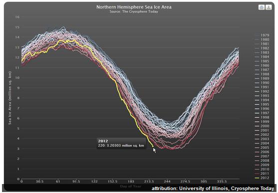
Arctic Sea Ice Forecast: "It's Going To Be Tough To Stay Cool". Here's a snippet from Gareth Renowden at Climate Change, The Next Generation: "Bad news from the Arctic is piling up as we head into the last few weeks of the melting season. The various measures of sea ice area, volume and extent and plummeting towards a new record minimum. I have therefore reviewed the Arctic sea ice melting seasons since 2007, and compiled my own forecast of how the rest of the year is going to pan out. Remember, you read it here first....
When Arctic sea ice sets a new record low in the next couple of weeks, the usual suspects will say "you can't trust area, sea ice extent is the only valid metric".
When Arctic sea ice extent sets a new record low in September, the following arguments will be run in parallel:
* There will be a frantic search for a definition of extent in which a new record was not set.
* There will be a complaint that the satellite record has been blighted by the failure of a sensor and the calibrations needed to get a new sensor in operation have corrupted the record.
* It will be claimed that it was all caused by the major Arctic storm that hit in August, and thus can't be attributed to global warming.
Photo credit: Kathryn Hansen, NASA.
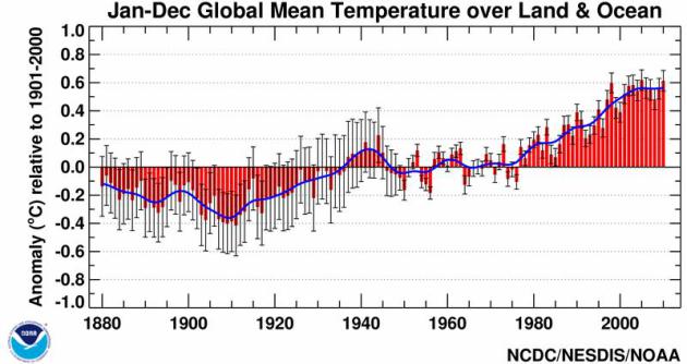
Signs Of Climate Change. Yes, I've made a startling discovery: people are much more likely to admit that climate change is taking place during the hot summer months than during February. It's easy to confuse weather and climate. I was struck by an Op-Ed in The New York Times; here's an excerpt: "...During hot spells, for example, more people accept that climate is changing, but a colder spell reverses those opinions. Everybody understands weather: it’s hot, cold, raining, snowing, windy and so on. Fewer people understand that a region’s climate is the frequency of such weather events: how often does it rain or get hotter than, say, 90 degrees? The Hansen paper shows that these frequencies have changed substantially, both globally and throughout the Northern Hemisphere. Hot and very hot days have become more frequent; very cold days less frequent."
No comments:
Post a Comment