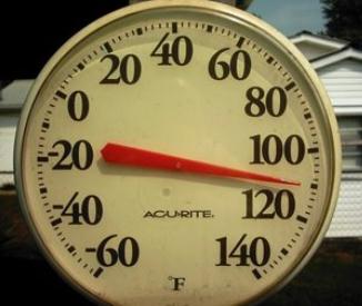
76 F. high on Friday in the Twin Cities.
73 F. average high for September 14.
60 F. high on September 14, 2011.
80+ F. highs likely today and Sunday.
.07" rain predicted for Monday as colder air arrives behind a clipper.
Frost possible in the Twin Cities metro by next weekend, coming nearly 2 weeks earlier than usual. Details below.
Flakes Next Week? O.K. I hesitated even sharing
this, because I'm not convinced f-f-f-flurries will reach as far south
as MSP. But a couple of the longer-range models are hinting at a touch
of snow late Monday night or Tuesday morning. Wouldn't that be fun? From
mid-80s Sunday to mid and upper 30s just 36 hours later...a 50-degree
temperature freefall? The way this year is going nothing would surprise
me, not even flurries on September 18.
Frosty Possibilities. It seems hard to comprehend,
with temperatures forecast to top 80 today and Sunday, but there is a
very good chance of a frost for much of the metro by next weekend,
coming roughly 2 weeks ahead of schedule. Here's more information from
Planalytics:
"
Starting on Tuesday, consumers east of the Rockies will be
reaching for a fleece jacket during the day and an extra blanket
overnight. While some areas enjoyed cooler overnight conditions this
week, next Tuesday and Wednesday (September 18th & 19th) is expected
to bring a 25 to 30°F decrease for both day time and overnight
temperatures compared to recent weeks across the Northern Plains and
Western Great Lakes. Frost is likely across these regions, including
the major population areas of Minneapolis, Green Bay, Madison, and
Milwaukee."
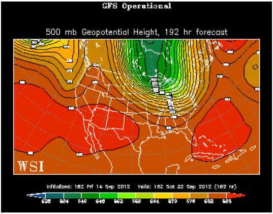
One Week From Today: September 22 or October 22? The
GFS forecast for 500 mb winds (18,000 feet) for next Saturday,
September 22, shows upper level winds howling from the north/northwest,
plunging unusually cold air south of the border. If this forecast
verifies (likely) we'll see our first frost within 6-8 days. The good
news: the same GFS model shows a rapid warming the last week of
September, temperatures climbing back into the 60s, possibly 70s. Map
above courtesy of WSI.
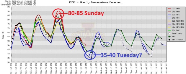
Over The Cliff. All the models show a fair amount of
continuity/agreement. After peaking above 80 today and Sunday an
industrial-strength Alberta Clipper will yank a taste of late October
into town Monday. By Tuesday morning temperatures in the metro may dip
into the 30s. It'll be cold enough aloft for snow by then - the big
question: will there be any moisture available to spark a few flakes?
From shorts to heavy jackets in a little over one day. Amazing. Graph:
Iowa State.
We Are #1 (For Heat). A high of 134 F. on July 10,
1913 at Greenland Ranch (Death Valley), California, USA now qualifies
as the hottest (official) temperature ever recorded on the face of the
Earth. The previous (Libyan) record of 136 F was just ruled invalid by
the WMO. From
NOAA: "
Since
1922, the record for highest temperature recorded at the earth's
surface was held at El Azizia, Libya. A temperature of 136.4 degrees was
recorded there on September 13, 1922. After review, the World
Meteorological Association has deemed this record invalid. Their
decision was due to various reasons including problematic
instrumentation, a new and inexperienced observer, and several other
issues. The record now falls to the American record at Furnace Creek in
Death Valley, California. The temperature there was recorded at 134
degrees on July 10, 1913."
"Nadine" becomes the 8th hurricane of 2012 in the Atlantic.
Iowa Environmental Mesonet.
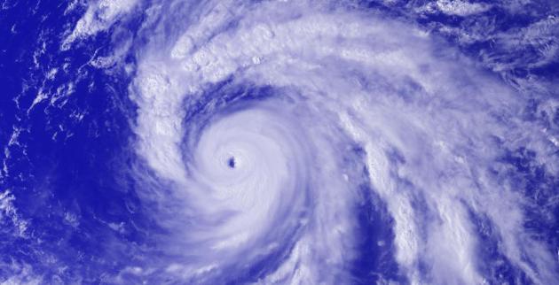
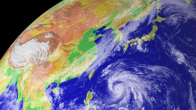
Super-Typhoon Sanba. A Category 4-5 hurricane,
"Sanba" is pushing toward Okinawa and South Korea. Details below.
Ultra-high-resolution visible image from late Friday courtesy of
Digital Typhoon.
"
They tell us the globe is cooling, not warming. They tell us
that any climate warming is completely natural. They insist that any
human impacts on our climate system are benign, mild, negligible or in
some cases beneficial. They tell us their claims are supported by
scientific studies but refuse to reveal them. All of these. All of
these. All of these are complete and total lies..." - from Doug Craig's "Climage of Change" post at redding.com; details below.
Bird Migration Forecasts Early Winter. Maybe the birds know something we don't...? Here's an excerpt from
sfgate.com: "
There’s
a saying, “Birds never lie.” If so, the best weather forecaster in the
West, the migratory sandhill crane, is predicting an early winter with
plenty of rain and snow. Over the years, the timing of the migration of
sandhill cranes south to the San Joaquin Valley has predicted winter
weather, both wet and dry. Early migrations have meant big winters.
Late migrations, the opposite. “I think 2012 sets a record for earliest
arrival,” said Gary Ivey, the International Crane Foundation’s Western
Conversation Manager. This fall’s verified migration started August 25
when 10 sandhill cranes were sighted in northern San Joaquin County by a
birdwatching group guided by Esther Milnes-Schmierer, a docent for the
Department of Fish and Game. In past years, the giant sandhill cranes
have first arrived in mid-September."
Two Surges Of October. Tuesday will be chilly enough
(upper 50s under a partly sunny sky after waking up to 36-41 F. lows),
but an even colder push arrives behind a second clipper late next week.
By next Sunday highs may be in the 40s to near 50 in the metro. The
average first frost in the metro: October 3-4. Somehow I think frost
will come early this year, maybe 2 weeks ahead of schedule.
Crop Update. Dr. Mark Seeley includes an interesting update on crop conditions in this week's
Minnesota WeatherTalk: "
A
national drought perspective was provided this week by Brad Rippey of
the USDA World Agricultural Outlook Board, highlighting the major
features of the USA drought. Excerpts include:
Crops and cattle in drought have begun to rise again. Overall, drought has shifted toward the north and west in recent weeks.
- U.S. corn in drought stands at 84%, up a percentage point from a week
ago. The corn harvest is underway, 15% complete nationally by
September 9.
- Soybeans in drought also rose a point – to 81%. The soybean harvest
is underway in a few areas, 4% complete nationally by September 9.
- Hay in drought rose 3 points to 66%, tying the high set on July 17 and 24.
- Cattle in drought reached a new high, rising 2 points to 74%.
- Winter wheat in drought is added this week, as planting is underway
(4% complete). Nearly three-quarters (74%) of the winter wheat area is
in drought.
- Due to expansion of drought in the nation’s mid-section, contiguous
U.S. drought coverage reached a record-high 64.16% on September 11.
The former record of 63.86% had been set on July 24."
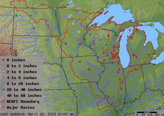
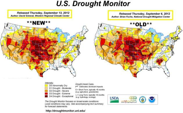
Spreading Drought. According to NOAA's
Drought Monitor,
St. Cloud, Willmar and the entire north metro is in a moderate drought
(again). In fact 44.39% of Minnesota is in a moderate drought, up from
39% last week. Severe drought is impacting the Red River Valley, pockets
of extreme drought from Pipestone to Jackson and Worthington.
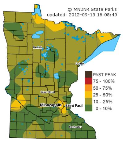
Fall Color Slightly Ahead of Schedule? According to the
Minnesota DNR
25-50% of trees in Hennepin, Ramsey and Dakota county are already
ripening up, about 7-10 days ahead of schedule. Dry weather may be
accelerating color, as trees across much of the metro are under stress.
Arctic Ice Melt Could Mean More Extreme Winters For U.S. And Europe.
What's happening at the top of the world will probably have a ripple
effect on winter weather from the USA to Europe and Asia. It's
counterintuitive, but a warmer Arctic means a smaller north-south
temperature contrast (what meteorologists call "baroclinicity"), which
in turn leads to lower jet stream winds. So what? A slower jet increases
the potential for blocking patterns, where weather patterns can stall
for days, even weeks at a time. Weather is more apt to fall into a rut.
It may be a snowy rut, or a mild rut - too early to say at this point in
time, but there's little doubt that record Arctic ice loss will have a
domino effect. Here's an excerpt of a good explanation from Climate
Nexus, Climate Central and
Huffington Post: "
The
record loss of Arctic sea ice this summer will echo throughout the
weather patterns affecting the U.S. and Europe this winter, climate
scientists said on Wednesday, since added heat in the Arctic influences
the jet stream and may make extreme weather and climate events more
likely. The “astounding” loss of sea ice this year is adding a huge
amount of heat to the Arctic Ocean and the atmosphere, said Jennifer
Francis, an atmospheric scientist at Rutgers University in New Jersey.
“It’s like having a new energy source for the atmosphere.” Francis was
one of three scientists on a conference call Wednesday to discuss the
ramifications of sea ice loss for areas outside the Arctic. The call
was hosted by Climate Nexus."
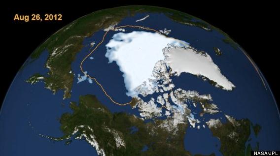
Image credit above: "
The extent of Arctic sea ice on Aug.
26, 2012, the day the sea ice dipped to its smallest extent ever
recorded in more than three decades of satellite measurements. The line
on the image shows the average minimum extent from the period covering
1979-2010." Credit: NASA/JPL.
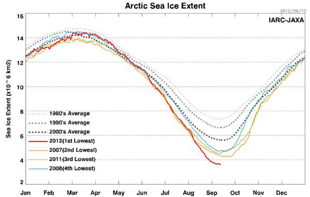
Latest Trends. Arctic ice loss should be reaching a
minimum in the next 1-2 weeks, leveling out after record ice loss. The
previous record ice loss was 2007. Ice coverage and volume is roughly
20% less than it was 5 years ago.
Graphic credit:
Arctic Sea Ice Monitor data: Japan Aerospace Exploration Agency, Earth Observation Research Center.
Hottest Spot on Earth? USA, Not Libya. Here's an excerpt of a post from the
WMO, the World Meteorological Organization: "
A
World Meteorological Organization panel has concluded that the
all-time heat record held for exactly 90 years by El Azizia in Libya is
invalid because of an error in recording the temperature. The
announcement follows a danger-fraught investigation during the 2011
Libyan revolution. Death Valley National Park in California, USA, now
officially holds the title of the world's hottest place - as symbolic
for meteorologists as Mt. Everest is for geographers....Consequently,
the WMO assessment is that the official highest recorded surface
temperature of 56.7°C (134°F) was measured on 10 July 1913 at
Greenland Ranch (Death Valley), California, USA. Full details of the
assessment are given in the on-line issue of the Bulletin of the
American Meteorological Society (http://dx.doi.org/10.1175/BAMS-D-12-00093.1)"
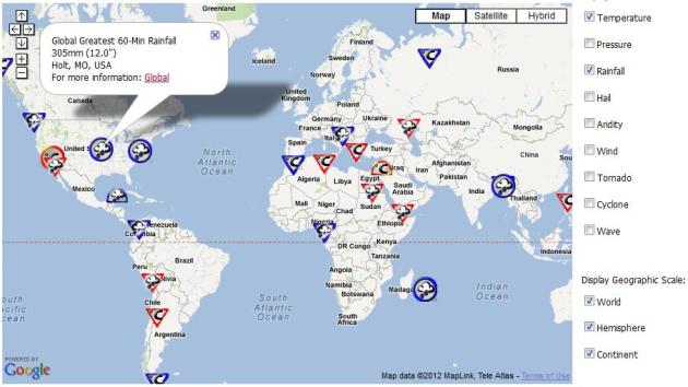
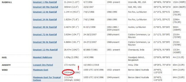
World Weather - Climate Extremes Archive. Here's a
great bit of trivia for your next party. "Did you know the world record
for rainfall in a 60 minute period is 12" at Holt, Missouri?" Crickets.
O.K. Maybe you don't want to publicize this (geeky) information, but
other weather enthusiasts may find this interesting.
Arizona State University has an interactive global map that shows world records.
Speaking Of Super-Typhoons. I didn't realize this,
but the world record for surface wind gusts is 253 mph, set in 1996 at
Barrow Island, Australia. Seems like that should have been a "Category
6". Source:
Arizona State University and WMO.
Drought of 2012: Status Quo. Not much change in the
U.S. Drought Monitor
- the driest conditions from the Midwest into the Central and Southern
Plains, a pocket of extreme/exceptional drought over eastern Alabama and
Georgia.
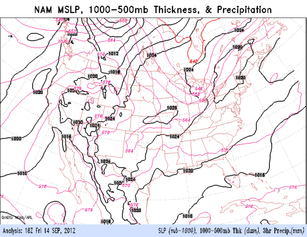
Weekend Weather Trends. Here is the latest 84-hour
NAM model, showing a fairly nice spell of moderate weather over the
northern tier states, a weakening cool front pushing showers into the
Northeast Friday night, skies clearing over the weekend across New
England. The best chance of heavy showers and T-storms extending from
Texas along the Gulf Coast; a growing chance of coastal showers for the
Carolinas by Sunday. A stronger cold front pushes showers into Minnesota
and the Upper Midwest late Sunday and Monday of next week.
Typhoon Sanba Headed For Okinawa, South Korea. Details from
CNN: "
A
typhoon slinging fierce winds moved north Saturday toward the Japanese
island of Okinawa, on a track to hit the Korean Peninsula, where
dozens of people were killed by a big storm last month. Tropical cyclone
Sanba had winds of 232 kilometers per hour (144 mph), said CNNI
Weather Anchor Jenny Harrison. "One expects and assumes that people are
beginning to already take serious precautions as to the arrival of
this very strong typhoon," she said. She predicted that storm surge
could prove to be a problem for islanders. "It's a large storm and it's
going to have a fairly wide-reaching effect," she said. "Okinawa is
pretty much in the path of this storm."
Details from
Digital Typhoon: "
Typhoon
SANBA was formed in Caroline Islands. Palau is now within the
gale-force wind area. The typhoon is forecast to move northward off the
east coast of Phillipines, which is known to be a favorable area for
typhoon intensification, so we need to keep alert on the development of
the typhoon." High-resolution imagery here.
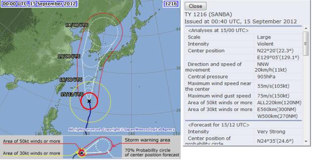
Sanba's Projected Track. Okinawa
may see a direct strike, the soggy remnants of "Sanba" forecast to swirl
north toward Korea. Track information courtesy of the Japan Meteorological Agency.
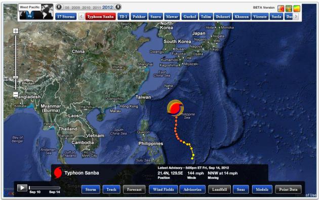
Hurricane Alley. Typhoons (same phenomenon as
hurricanes) tend to be bigger and stronger in the western Pacific than
in the Atlantic, about 40% larger, on average, according to the AMS.
Why? The Pacific is considerably bigger than the Atlantic, a longer,
warmer "fetch" of water for these storms to get going and intensify into
monsters. The map above from Ham Weather shows where "Sanba" has been -
it looks like it will spare the Philippines and Taiwan. South Korea and
far western Japan may not be quite so lucky. Sanba may weaken slightly
as it pushes north, moving over cooler ocean water.
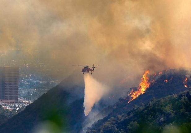
Brushfires Snarl 405 In L.A. Los Angeles has been sizzling, and unusually, hot, dry Santa Ana winds are fanning brushfires. Details (and photo above) from
The Los Angeles Times: "
The
northbound Getty Center offramp of the 405 Freeway has been ordered
shut down at the height of rush hour as emergency crews scramble to
fight a growing brushfire in the Sepulveda Pass, just east of the
freeway. The California Highway Patrol has also closed Sepulveda
Boulevard between Moraga Drive and the Getty Center. The center itself
was closed and evacuated earlier as a precaution."
Weekend Details. The ECMWF model suggests that today
will be the sunnier of the two days this weekend; Sunday may be a few
degrees warmer, low to mid 80s with increasing clouds. Showers may hold
off until late Sunday night and Monday.
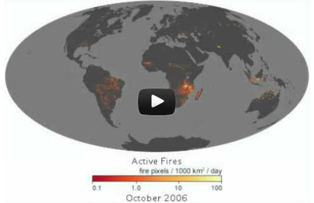
The Evolution Of Wildfires Around The World. Here's a link to an amazing animation, courtesy of The New York Time's Andy Revkin and
The Washington Post: "
Andrew Revkin of Dot Earth passes along
this fascinating video from the NASA Earth Observatory showing the
“global pulse of fire” around the world since 2000. NASA offers this bit
of commentary: The fire maps show the locations of actively burning
fires around the world on a monthly basis, based on observations from
the Moderate Resolution Imaging Spectroradiometer (MODIS) on NASA’s
Terra satellite. The colors are based on a count of the number (not
size) of fires observed within a 1,000-square-kilometer area. White
pixels show the high end of the count —as many as 100 fires in a
1,000-square-kilometer area per day. Yellow pixels show as many as 10
fires, orange shows as many as 5 fires, and red areas as few as 1 fire
per day."
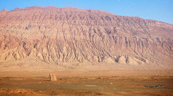
Where Is The Hottest Place On Earth? Easy question, but the answer is a bit problematic. Here's an excerpt of an interesting article from
NASA's Earth Observatory. "
In
October 2004, ecologist Steve Running visited the Flaming Mountain, a
ridge of dark red sandstone on the edge of the Taklimakan Desert and
the Tian Shan range. The surface of the mountain is said to reach
temperatures of 50 to 80°C (122 to 175°F) in the summer, and a nearby
tourist center marks the spot with a huge golden thermometer. It is the
hottest place in China, if not the world, or so says the local lore."
Photo credit above: "
According to local lore, the Flaming
Mountain is the hottest spot in China. After visiting the site,
scientists used NASA data to find out for sure." (
Photograph ©2011 oh contraire.)
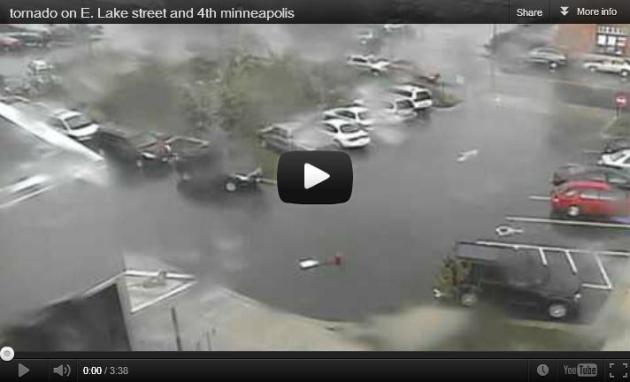
Top 10 Tornadoes Caught On Surveillance Camera. This
is interesting - now that we have so many webcams recording video
around the USA, every now and then they catch the arrival of a
full-blown tornado. Some incredible footage in this post from
ustornadoes.com: "
I
chose these videos — what I consider to be the top 10 tornadoes caught
on security cam — to show the versatility of surveillance solutions.
Granted, the cameras that caught the tornadoes presented here had a
different goal when initially installed. But as you can see below, these
cameras can often go beyond their intended purpose. And sometimes,
with a little luck, you can get a glimpse at something that otherwise
might have gone unseen."
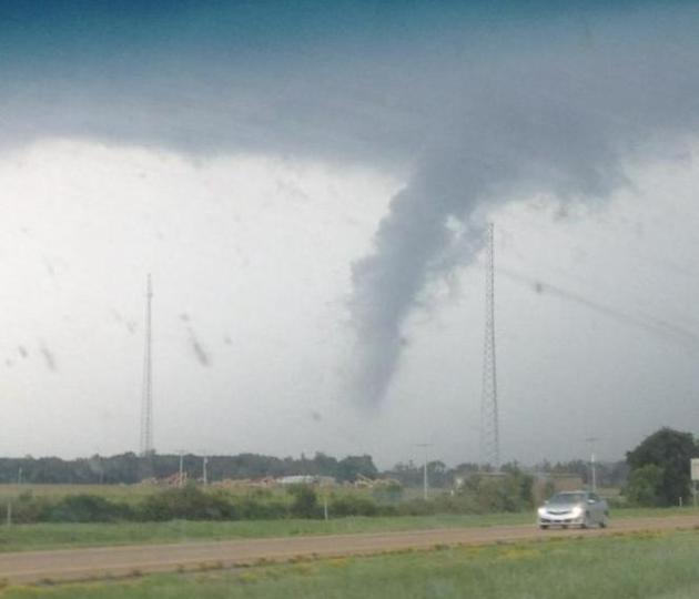
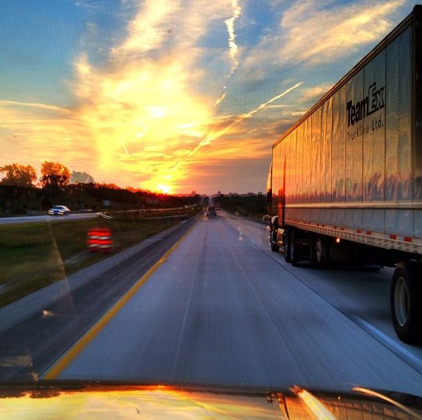
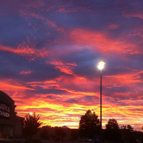
Favorite Photos...
Alabama Funnel. Details from Swammy_75 and Twitter: "
Driving to gameday in Fayetteville and saw this by the interstate. ."
Iowa Sunrise. Notice the jet contrails spreading out
into high, thin cirrus, which keep nighttime temperatures a couple
degrees warmer, daytime highs a few degrees cooler.
Instagram courtesy of @tyrantd.
Purple Haze. A rising sun in Athens, Georgia illuminated the underside of a ragged altocumulus deck of clouds. Photo courtesy of
Justin I Daniel.
In-Flight Entertainment. Here is a link to a
remarkable web site, one that shows near real-time flights in the air at
any given moment. Many flights are delayed by at least 5 minutes, for
security reasons. After visiting
flightradar24.com I have newfound respect for air traffic controllers. Yeah - these men and women are probably underpaid.
Smartphone Shipments Tipped To Pass One Billion In 2016.
It's nothing short of a revolution, from desktop computing to having a
supercomputer in your pocket. One that makes voice calls too. Details
from
gizmag.com: "
The
latest research from NPD DisplaySearch suggests that the smartphone is
quickly heading for ubiquity, with annual shipments expected to exceed
one billion in 2016. Given there are only seven billion people on the
planet, a significant proportion of the earth's inhabitants can be
expected to be carrying one by that point, signalling a huge shift in
computer ownership. Who would have thought just ten years ago that most
of us would be carrying a computer in our pocket."
Photo credit above: "
Annual smartphone shipments are predicted to double by 2016." (Photo:
Shutterstock)
Not Your Grandfather's Fishing Boat. 210 mph out on the open ocean? Can you troll behind this baby? Check out the amazing
YouTube video focused on Miss GEICO: "
The
third Outpeformer mini doc follows Miss GEICO's boat pilot, Marc
Granet, to chronicle what it takes to command a championship winning
team and drive a boat capable of speeds in excess of 210 miles per hour,
over open ocean and choppy waterways." More details
here.
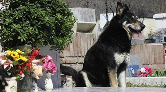
Dog Stands Guard Over Deceased Owner's Grave For Six Years. A remarkable (and amazingly sad) story from
Yahoo News; here's an excerpt: "
An extremely dedicated dog has continued to show its loyalty, keeping watch on its owner's grave
six years after he passed away. Capitan, a German shepherd, reportedly
ran away from home after its owner, Miguel Guzman, died in 2006. A
week later, the Guzman family found the dog sitting by his grave in
central Argentina. Miguel Guzman adopted Capitan in 2005 as a gift for
his teenage son, Damian. And for the past six years, Capitan has
continued to stand guard at Miguel's grave. The family says the dog
rarely leaves the site."
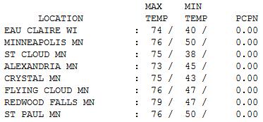
Chamber Of Commerce-Worthy. Once again today it
looked like the skyline was posing for a postcard. Under a perfect-blue
sky highs surged into the 70s statewide, ranging from 73 at Alexandria
to 75 St. Cloud, 76 Twin Cities and 79 Redwood Falls. I hope you're
enjoying this. Next week we see a little atmospheric payback for all
this weather bliss.
Paul's Conservation Minnesota Outlook for the Twin Cities and all of Minnesota:
TODAY: Summer flashback! Sunny, breezy, lake-worthy. Winds: South 10-15. High: 82
SATURDAY NIGHT: Clear and mild. Low: 58 (60+ in the downtowns).
SUNDAY: Sun fades, last warm day in sight. Winds: S/SW 10-15. High: 83
SUNDAY NIGHT: Chance of showers, possible thunder. Low: 52
MONDAY: Gusty and colder with showers likely. High: 56
TUESDAY: Partly sunny, brisk - light jacket/sweatshirt weather returns. Low: 41. High: 58
WEDNESDAY: Next clipper, few showers. Low: 49. High: 68
THURSDAY: Cool wind, clouds increase. Low: 43. High: 59
FRIDAY: Mostly cloudy, hello late October! Low: 39. High: 54
* highs may hold in the 40s and low 50s next weekend with a good chance of a frost/freeze across much of Minnesota.
An Early October?
September flurries in the Twin Cities are
unusual, but not unprecedented. On September 24, 1985 nearly a half inch
of slush delighted MSP residents. No, really! Why am I bringing this
up? I sense that it's almost payback time for a record warm summer. 95F
on Tuesday was only the 8th time it's been that hot on or after
September 11 since 1891
What goes up must come down. Record heat is
often followed by unusual chill, as the atmosphere attempts to reach
equilibrium. I've seen it happen too many times.
We're in uncharted waters (literally) over the
Arctic; now one Big Slushie. How record heating at the top of the world
trickles down into our latitude has yet to be determined, but I'm
betting the farm that autumn will not come quietly this year.
An October-like SLAP is shaping up for next
week. Expect a few raw-gray days: 40s north and 50s south; an early
frost here - even a coating of slush for Duluth by next Sunday? No, I'm
not kidding. We'll see more 70s come October, but for now: early
jackets.
Enjoy 80s this weekend. Not sure when we'll see this again.
Then again, you can't call it Indian Summer until you've endured the first frost, which should come early this year.
Climate Stories...
Fossil Fuel Industry Ads Dominate TV Campaign. Have
you noticed any commercials for "clean coal" in recent weeks? Me too.
Details on the geyser of fossil-fuel money involved in this year's
presidential campaign from
The New York Times; here's an excerpt: "
When Barack Obama first ran for president, being green was so popular that oil
companies like Chevron were boasting about their commitment to
renewable energy, and his Republican opponent, John McCain, supported
action on global warming. As Mr. Obama seeks re-election, that world is a distant memory. Some of the mightiest players in the oil, gas and coal
industries are financing an aggressive effort to defeat him, or at
least press him to adopt policies that are friendlier to fossil fuels.
And the president’s former allies in promoting wind and solar power and caps on greenhouse gases? They are disenchanted and sitting on their wallets."
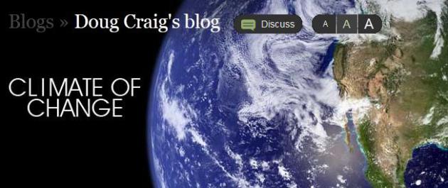
Why The New AMS Statement On Climate Change Matters. Doug Craig has some interesting perspectives in his latest
Climate of Change post at redding.com; here's an excerpt: "
As I close in on nearly 1,000 blogs, mostly focused on global climate change, I find this new "Information Statement of the American Meteorological Society on Climate Change"
as extremely important. There are forces within our society, all of
which stand outside the scientific establishment, which consistently
seek to impress upon the public mind a deep and corrosive lie. They tell
us the globe is cooling, not warming. They tell us that any climate
warming is completely natural. They insist that any human impacts on
our climate system are benign, mild, negligible or in some cases
beneficial. They tell us their claims are supported by scientific
studies but refuse to reveal them. All of these. All of these. All of
these are complete and total lies."
House Republicans Scrub Climate Change Concerns From EPA Bill. Remarkable. Let's just ignore the elephant in the living room. Details from
The Hill: "
The
latest House bill aimed at thwarting climate change regulations drops
previous language that acknowledged scientific concerns about global
warming and evidence of rising temperatures and sea levels. The House is
slated to vote next week on several bills aimed at battling what
Republicans call a White House “war” on coal — a package
that includes previously passed legislation to block greenhouse gas
rules from the Environmental Protection Agency (EPA). But the new
version of the greenhouse gas bill from House Energy and Commerce
Committee Chairman Fred Upton (R-Mich.) omits a “sense of Congress”
section that describes scientific concerns about climate change while
casting it as an international issue."
Climate Chronicles: Climate Change Becomes A Business Reality. The story from
Bloomberg Businessweek; here's an excerpt : "
This
is the year climate change should have hit home. The first eight
months are the hottest on record in the U.S., and Arctic sea ice is
about to hit a record low. Extreme weather, as we’ve come to call it,
has affected everything from the juiciness of the steak at Peter Luger
(high corn prices mean steer are being killed before there’s sufficient fat in the marbled meat) to crime rates, as some blame the recent heist
of $30 million of maple syrup in Quebec to a one-third drop in U.S.
production. No wonder the Carbon Disclosure Project has seen a sharp
spike in the number of large companies that view global warming as an
immediate threat to their operations. The percentage that see danger
right now has jumped to 37 percent of respondents in this year’s CDP
Global 500 Climate Change Report, released on Sept. 12, up from 10
percent just two years ago."
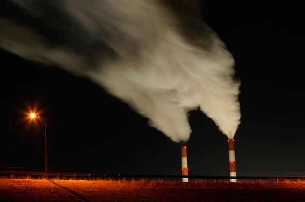
Photo credit: Charlie Riedel/AP Photo. "
Time exposure of smokestacks at the La Cygne Generating Station coal-fired power plant in Kansas."
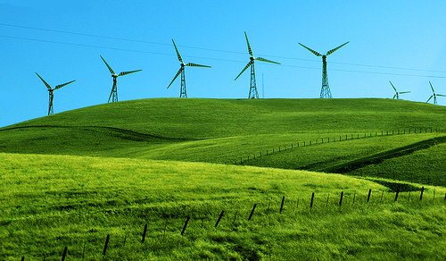
NRDC Report: Typical Wind Farm Supports Nearly 1,100 Jobs, Adds Millions Of Dollars To Local Economies. Here's an excerpt from a recent press release from the
Natural Resources Defense Council: "
Each
major wind farm in America creates nearly 1,100 jobs and can add tens
of millions of dollars in new taxes and other benefits to the
communities where they’re located, according to two new reports from the
Natural Resources Defense Council. A new 250-megawatt wind farm will
create 1,079 jobs throughout the many steps of building that wind farm,
according to the NRDC report “American Wind Farms: Breaking Down the
Benefits from Planning to Production.” These are positions in
manufacturing, construction engineering and management, among other
areas. But the benefits don’t end there, a separate NRDC study on the
secondary impacts of the wind energy industry shows."
Climate Change Will Extend Hay Fever Season By Six Weeks.
Oh that's just great. I'm liking the milder trends to some extent, but 6
more weeks of sneezing, wheezing and sniffling? Details from The
Guardian and
Mother Jones: "
Hay
fever sufferers face longer pollen seasons and highly allergenic new
strains from invasive plants, a new report on the health effects of
climate change on the UK warned on Tuesday. Global warming will cause
earlier flowering, possibly extending the hay fever season by six
weeks, and enable new species to grow in the UK. Pollen is also
getting more potent, packing more allergen into each grain. The report,
from the Health Protection Agency
(HPA), analyses a wide range of risks including killer heatwaves,
increased flooding, greater food poisoning and new infectious diseases
carried by mosquitoes."
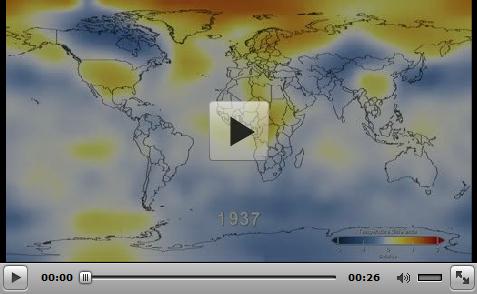
Hot Graphics - Global Warming In Images. Here's a
snippet of a post that summarizes the global trends we're witnessing in
recent decades with excellent visuals and animations; from
getenergysmartnow.org: "..
This NASA graphic impressively provides 131 years of temperature data in 26 seconds. "The
global average surface temperature in 2011 was the ninth warmest since
1880, according to NASA scientists. The finding continues a trend in
which nine of the 10 warmest years in the modern meteorological record
have occurred since the year 2000. … The comparison shows
how Earth continues to experience warmer temperatures than several
decades ago. The average temperature around the globe in 2011 was 0.92
degrees F (0.51 C) warmer than the mid-20th century baseline."
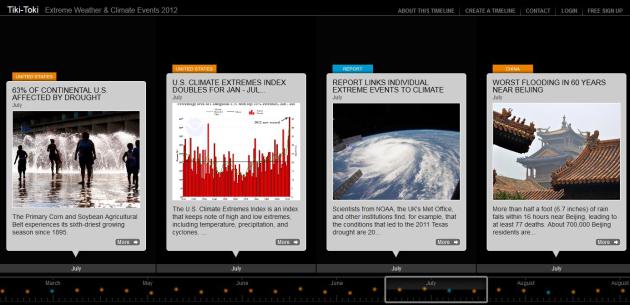
Extreme Weather & Climate Events: 2012.
Here is a remarkable timeline summary of 2012: the warmest, and
probably the most severe year in U.S. history, but an unusual number of
extremes were witnessed worldwide. Check it out for yourself at
tiki-toki.com.
Heat: A Bridge To Climate Consensus? Huffington Post has the story; here's an excerpt: "
Excessive heat is becoming a public health threat, especially in cities. It leads to heat stroke, heat exhaustion, and is a catalyst for ground-level ozone creation as well as asthma and lung disease.
However, and perhaps even more importantly, heat may be the bridge to
climate consensus. While extreme heat is not climate change in itself,
it amplifies the heat impacts of climate change
-- thus also amplifying the threats to human health. It therefore
provides an opportunity that allows climate believers, agnostics, and
deniers to work together to address a common threat to our society.
Regardless of the motivations, dealing with extreme heat can help
mitigate climate change, providing added benefits to society."
Arctic Warning: As The System Changes, We Must Adjust Our Science. Here's an excerpt from
Climate Code Red: "
The Arctic sea-ice big melt of 2012 “has taken us by surprise and we must adjust our understanding of the system and we must adjust our science
and we must adjust our feelings for the nature around us”, according
to Kim Holmen, Norwegian Polar Institute (NPI) international director.
From Svalbard (halfway between mainland Norway and Greenland), the BBC’s
David Shukman reported
on 7 September that Holmen had described the current melt rate “a
greater change than we could even imagine 20 years ago, even 10 years
ago”.
Photo credit above: "
Northern Polar Institute Research
Director Kim Holmen, left, with UN Foundation Board Chairman Ted Turner
and President Timothy Wirth in the Arctic."
Faking That NASA Faked The Moon Landing. More on conspiracy theories and a possible link to ongoing climate change denial from
shapingtomorrowsworld.org: "
Data
integrity is a central issue in all research, and internet-based data
collection poses a unique set of challenges. Much attention has been
devoted to that issue and procedures have been developed to safeguard
against abuse. There have been numerous demonstrations that internet
platforms offers a reliable and replicable means of data collection,
and the practice is now widely accepted. Nonetheless, each data set must
be examined for outliers and “unusual” responses, and our recent paper
on conspiracist ideation and the motivated rejection of science is no
exception. Perhaps unsurprisingly, after various unfounded accusations
against us have collapsed into smithereens,
critics of our work have now set their sights on the data. It has been
alleged that the responses to our survey were somehow “scammed,”
thereby compromising our conclusions."
Permafrost Thaw Will Speed Up Global Warming, Study Says.
CBC News has the story; here's an excerpt: "
Permafrost
soils in Canada's Arctic are melting at a rate that will significantly
speed up global warming, according to new research from the University
of Victoria. The study, published this week in Nature Geoscience,
predicts that the thawing permafrost will release between 68 billion
and 508 billion tonnes of carbon into the atmosphere by the year 2100.
As a result of those carbon emissions, researchers say the Earth's
temperature will rise by more than 0.5 C by the end of the century." Image above: NASA.


No comments:
Post a Comment