Stop the presses
By Paul Douglas
Does anyone still say that? October was the first time in 17 months Twin Cities temperatures were cooler than average. Talk about an odd year. For the first time on record March was warmer than October, according to Pete Boulay at the State Climate Office.
Meanwhile the Army is trucking gasoline into New York; the Navy is helping out in New Jersey. Recovering from Sandy may take years in some communities. Don't be shocked if your insurance premiums go up. Munich Re reports North America has seen the most weather extremes on Earth since 1980, with over a trillion dollars in damage. The study shows weather-related "loss events" in North America nearly quintupled in just the last three decades. 30,000 people in North America died from severe weather since 1980. More data points.
We expect quiet weather to linger; I don't see a respectable storm of any flavor into mid-November. Minnesota's drought will continue to deepen. One silver lining: after a cool spell into midweek 50s may return by late week. I wouldn't be shocked to see 60 by next Saturday. Then again, after March flowers in full bloom and a 7-month boating season in Minnesota, very little shocks me anymore.
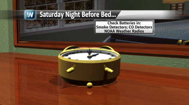
Paul's Conservation Minnesota Outlook for the Twin Cities and all of Minnesota (and western Wisconsin too):
SUNDAY: Mix of clouds and sun. SE winds 3-8 mph. High 47. Low 30.
MONDAY: Clipper stays west. Patchy clouds. High 46. Low 33.
TUESDAY: Election Day (rain) showers. High 47. Low 35.
WEDNESDAY: Sunnier, drier, a bit milder. High 50. Low 32.
THURSDAY: Plenty of sun, not bad at all. High 54. Low 38.
FRIDAY: Sun lingers, hint of Indian Summer. High 55. Low 37.
SATURDAY: November golf? Clouds increase. High 60. Low 39.
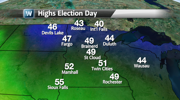
Looking ahead to Election Day Tuesday, temperatures should be in the 40s for most of the area. There is the chance of some rain, mainly from the Twin Cities eastward. Otherwise, no storms (and no snow) that should hinder your chances of reaching the polls.
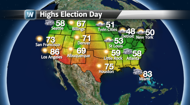
Looking nationwide for Election Day, relatively nice weather will dominate. The only areas we will have to watch for rainy weather is in the northwest, parts of Minnesota and Wisconsin, as well as the southeast. The southeast activity will be associated with a possible Nor'Easter as we work into Wednesday and Thursday hitting the same areas that Sandy just went through.
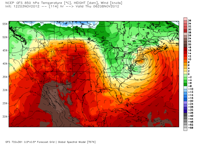
We should see some warmer temperatures as we work into midweek. This 850 mb temperature output for early Thursday shows the possible nor'easter on the east coast, as well as some warmer temperatures aloft moving into the Midwest. This should bring us temperautures into the upper 40s and 50s. Model image via WeatherBell Models.
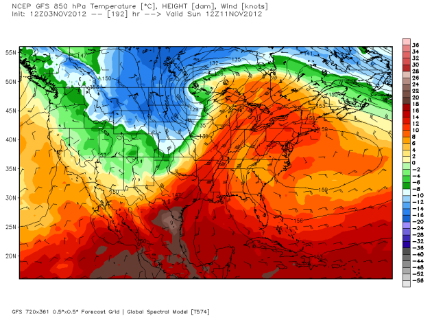
Unfotunately the warmth doesn't last, however, as another system comes into the area late next weekend, bringing the possibility of rain (and perhaps some snow) with it. It's a week out, and things can change, however winter has to come at some point... Way too early to be getting our hopes up on this system though! Model image via WeatherBell Models.
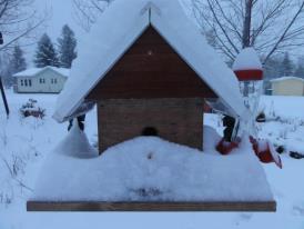
Just a reminder of what is supposed to happen in winter... snow! Parts of North Dakota saw 6" + on Friday, including the Walhalla, ND area. Photo above via the Frost Fire Ski and Snowboard Area.
Next Northeast Storm?
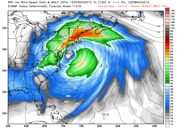
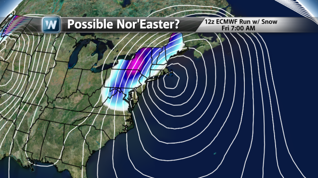
As each model run comes in, there is much more confidence in the possibility of a storm mid-to-late week in the northeast. This shows the 12z ECMWF run from Saturday, showing a strong system off the coast of New Jersey coast Thursday Morning. Definitely not a welcome site to those recovery from Sandy. Model image via WeatherBell Models.
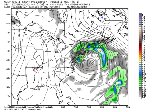
This is the GFS run from 12z on Saturday, showing an even stronger storm than the ECMWF coming onshore near East Hampton or Montauk late Thursday or early Friday. From there the storm moves into Connecticut and Rhode Island. Model image via WeatherBell Models.
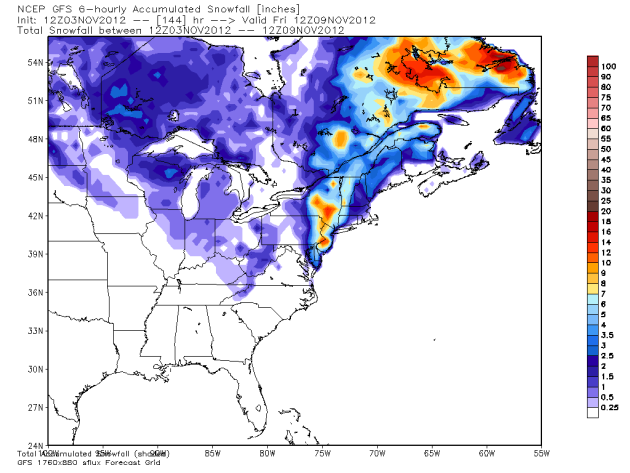
The GFS is outputting between a half a foot and a foot of snow in parts of Jersey and southeast New York from this next system. Model image via WeatherBell Models.
We'll keep an eye on the system for the northeast. Have a great Sunday, and enjoy the weather!
Follow me on Twitter at: @weathrlver
No comments:
Post a Comment