27 F. high in the Twin Cities Friday; coldest day of the winter season so far.
37 F. average high for November 23.
52 F. high on November 23, 2011.
.5" snow fell yesterday at Twin Cities International Airport.
Living With Risk
We all know that risk is part of life. Any time
you grill, cross the street or board a plane you're living with
manageable, acceptable levels of risk.
Living by a river, building a home in Tulsa with
no basement, buying a condo on the beach within 10 feet of sea level? A
whole new level of risk.
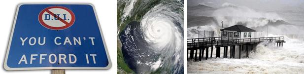
Consider: drinking and driving doesn't mean a DUI or fatal accident is guaranteed. But the risk of both go up exponentially.
A warmer ocean and rising sea level didn't spawn
Sandy, but it did make the storm worse; the atmospheric equivalent of
tossing an extra log on the fire.
And for all the grief we get for enduring
Minnesota winters remind your Florida friends that those annoying cold
fronts innoculate us from the worst storms on Earth.
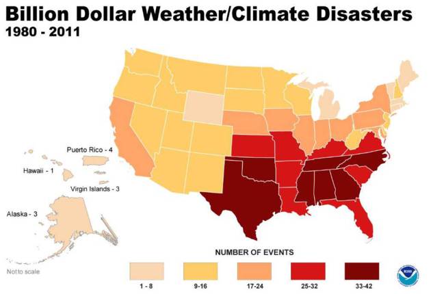
Your odds of being in a billion dollar storm are 3-4 times higher from Texas to Florida to the Carolinas. Details below.
Winds ease up today - sunny, dry weather into
early December. Just about the time I'm ready to throw in the towel on
Indian Summer, model guidance makes me do a double-take. The ECMWF shows
another warm bubble of high pressure expanding north next weekend.
We'll see more 50s, a 1 in 3 shot at 60.
In early December?
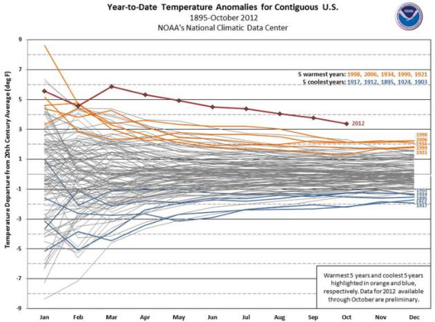
2012: Off-The-Scale Warm. NOAA released the latest data for the lower 48 states, showing that it's pretty much a sure bet that this year will be the warmest ever observed in the USA, warmer than 1998, 1999 and 2006.
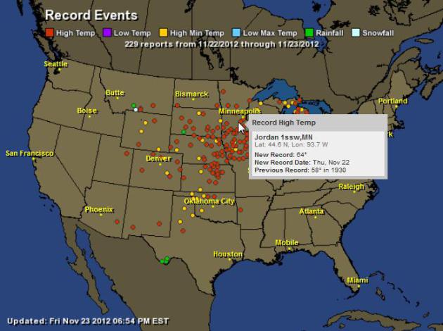
Record Warmth. According to NOAA there were 229 record events on Thursday, most of them record highs over the Plains, Upper Midwest and Great Lakes. Map: Ham Weather.
Record Highs on Thanksgiving Day
Pellston, MI 68
Sault Ste Marie, MI 65
Traverse City, MI 65
Gaylord, MI 63
Chicago, IL 63 (third warmest Thanksgiving day on record)
Wausau, WI 62(tie)
Alpena, MI 61
Green Bay, WI 61
Houghton Lake, MI 60
Minneapolis 60
Rhinelander, WI 59
Marquette, MI 58
Duluth, MN 52(tie)
* my thanks to Julie Gaddy at Earth Networks for sharing this information. Interactive map above: Ham Weather.
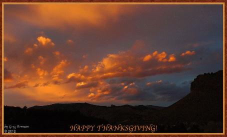
** photo above courtesy of Greg Berman, from Lyons, Colorado.
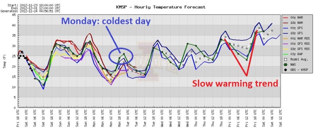
Weekend Thaw, Chilly Monday, Then Slow Warming Trend.
Friday was about as cold as it will get looking out the next 12 days or
so, although Monday may come close. After recovering to near 32 today
and low to mid 30s Sunday the next clipper pulls a reinforcing surge of
chilly air into Minnesota Monday. Graphic: Iowa State.
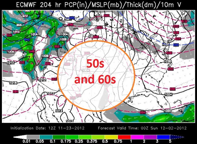
More Hints Of Indian Summer (Lite). Not sure we'll see 60 again, but can I interest you in 50s? The ECMWF map above is valid next Saturday evening, showing another ridge of high pressure expanding northward across the Plains. In fact we'll probably see a few days above 50 the first week of December. Map above: WSI.
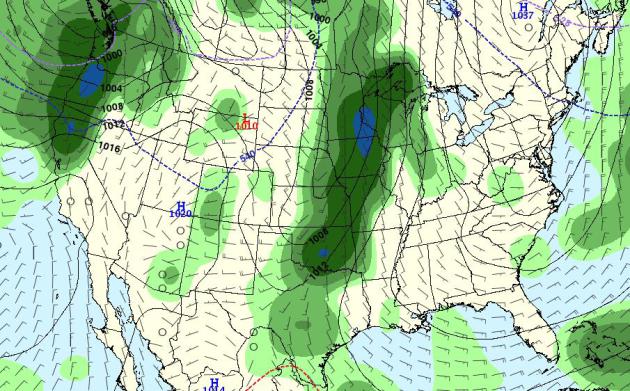
December...Rain? The GFS forecast for a week from Tuesday (December 4) shows the "540 line", the approximate rain/snow line, slicing across the Dakotas - the atmosphere potentially mild enough for rain. On December 4. The way this year is going nothing much surprises me anymore.

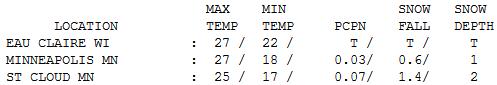
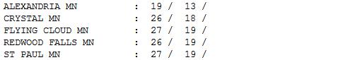
Instant Winter. Was it really 60 on Thanksgiving Day (before the arctic front arrived?) Good grief. In spite of a little PM sunshine highs were stuck in the teens and 20s, ranging from 19 at Alexandria to 25 St. Cloud (where 1.4" snow fell) to 27 in the Twin Cities.
Paul's Conservation Minnesota Outlook for the Twin Cities and all of Minnesota:
TODAY: Sun fades, less wind. Better. Winds: S 10. High: 33
SATURDAY NIGHT: Patchy clouds, not as cold as recent nights. Low: 25
SUNDAY: Cool sun, no travel headaches getting home. High: 35
MONDAY: Next clipper, turning cooler under a mostly-blue sky. Low: 15. High: 27
TUESDAY: Patchy clouds. Still quiet. Low: 14. High: 31
WEDNESDAY: Blue sky, too dry out there. Low: 18. High: 34
THURSDAY: Plenty of sun, a bit milder. Low: 24. High: 42
FRIDAY: Clouds increase. No weather-drama expected. Low: 27. High: 39
Climate Stories....
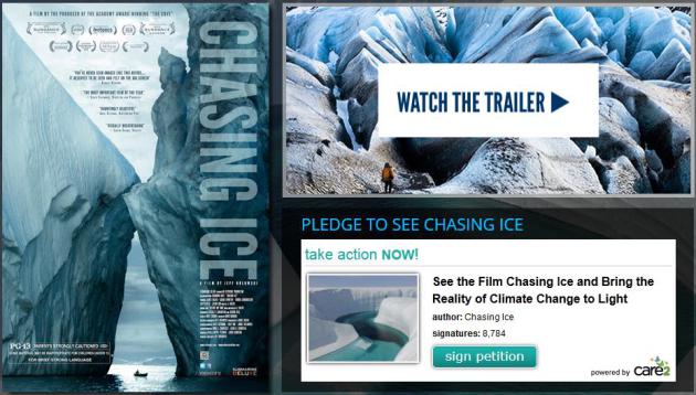
* more on the documentary "Chasing Ice" here.
No comments:
Post a Comment