
What Happened? How did expected snowfall amounts double in the span of 24 hours? Every storm is different, and this one was especially fickle, for a number of reasons. Usually a thick layer of cold air needs to be in place for a major snowfall. We didn't have that with this storm, temperatures aloft fairly close to freezing this morning. But the upward motion, the vertical velocities associated with this storm are unusually intense. Not only does this create moderate to heavy snow, but strong upward motion cools the column of air overhead, preventing a changeover to ice or rain, which would keep final amounts down. Saturday morning is still looked like the axis of heaviest snow would set up from near Alexandria and Willmar to Little Falls, Brainerd and the North Shore of Lake Superior. By afternoon models were shifting that axis from southwest-northeast, to a more west-east configuration, stretching from Willmar to the Twin Cities to Baldwin, WI. Yes, every weather scenario is fluid - this one surprised me a little. I realize the snow is a hardship, a bummer for many people. All it takes is one good fall on ice to ruin your winter (or worse). I get it. But you live in Minnesota - where snow is part of the landscape (some winters). If you don't like it, buck it up - this too shall melt (although no time soon, not before Christmas). If you happen to like snow - congratulations. We all just won Minnesota's Snow Lotto.
For once.
* the latest observed snowfall amounts are here, courtesy of the National Weather Service.
Snowy Resources. Here we go. The snow will pile up fairly rapidly today, coming in waves from west to east. I've included a few links so you can see the latest snowfall reports, Doppler radar images and road conditions. Be careful out there - conditions on area highways will go downhill as the day goes on; a potential for near-blizzard (white-out) conditions over central and southwestern Minnesota by afternoon as winds kick in behind this intensifying storm. Snow lovers will be in heaven. Commuters? Not so much.
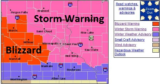
Here's the latest on the Blizzard Warning, which is getting uncomfortably close to the Twin Cities, from the NWS:
...MAJOR WINTER STORM WILL CONTINUE TO IMPACT THE AREA THROUGH
THIS EVENING...

...BLIZZARD CONDITIONS EXPECTED ACROSS WESTERN MINNESOTA THIS
AFTERNOON AND EVENING...

.A BLIZZARD WARNING REMAINS IN EFFECT FOR MUCH OF WEST CENTRAL
MINNESOTA THIS AFTERNOON DUE TO THE COMBINATION OF MODERATE TO
HEAVY SNOWFALL AND STRONG NORTHWEST WINDS BETWEEN 20 AND 40 MPH. A
WINTER STORM WARNING IS IN EFFECT TODAY FOR EAST CENTRAL MINNESOTA
AND WEST CENTRAL WISCONSIN FOR HEAVY SNOWFALL. FAR SOUTHERN
MINNESOTA REMAINS UNDER A WINTER WEATHER ADVISORY TODAY FOR LIGHT
TO MODERATE SNOWFALL.

A POWERFUL WINTER STORM WILL CONTINUE TO AFFECT MINNESOTA AND WEST
CENTRAL WISCONSIN FOR THE REMAINDER OF THE DAY. SNOW WILL EXPAND
THIS MORNING AND BECOME HEAVY AT TIMES TODAY. BEHIND THE LOW
PRESSURE SYSTEM...SUSTAINED NORTHWEST WINDS OF 20 TO 30 MPH ARE
EXPECTED OVER WESTERN MINNESOTA THIS AFTERNOON BEFORE GRADUALLY
TAPERING OFF THIS EVENING. SOME WIND GUSTS MAY EXCEED 40 MPH.
CONSIDERABLE BLOWING AND DRIFTING SNOW WILL RESULT IN WHITEOUT
CONDITIONS MAKING TRAVEL NEARLY IMPOSSIBLE BY THIS AFTERNOON.
AREAS OF BLOWING AND DRIFTING SNOW ARE ALSO EXPECTED FARTHER
EAST...BUT LIGHTER WINDS PRECLUDE THE ISSUANCE OF A BLIZZARD
WARNING AT THIS TIME.

TEMPERATURES WILL PLUMMET BEHIND THE SYSTEM TO WELL BELOW ZERO
LATE TONIGHT OVER WESTERN MINNESOTA WITH WIND CHILL READINGS AS
LOW AS 20 TO 30 BELOW. TRAVEL IN THE BLIZZARD AND WINTER STORM
WARNING AREAS IS NOT ADVISED. TRAVEL WILL BE VERY DIFFICULT AND
STRANDED MOTORISTS RISK GETTING FROSTBITE OR HYPOTHERMIA DUE TO
THE FRIGID WIND CHILL LATE THIS EVENING AND TONIGHT.
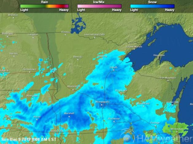
Latest Radar. A Conga Line of snow bursts will set up from Marshall and Willmar into the Twin Cities today; the snow probably won't taper much until late afternoon. By then gusty winds will kick in - sparking blowing and drifting. Travel may get progressively worse as the day goes on. For the latest radar image from Ham Weather click here.
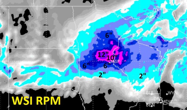
Very Plowable. This storm may be crippling for parts of central and west central Minnesota, the result of near-blizzard conditions later today as winds increase. Metro? Plowable indeed, with anywhere from 5-10" of snow by 4 or 5 pm. I wouldn't be surprised to see a foot near St. Cloud and Mille Lacs; the best chance of 10" or more in the metro over the northern suburbs. Model guidance above courtesy of WSI.
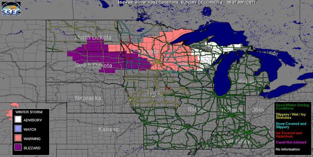
Road Conditions. The red-shaded roads show icy and snow-covered roads. Click refresh on your browser to get the latest road conditions from the University of Wisconsin. Only the brave and foolish will be on the highways later today.
No comments:
Post a Comment